Tag: EU

  • Inside Galileo HAS: A new era of free high-precision GNSS

    Inside Galileo HAS: A new era of free high-precision GNSS

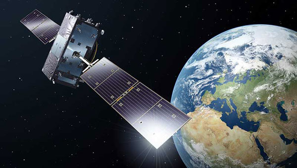
    Developed by the European Union, Galileo is an independent, global, satellite-based navigation system that provides a range of services. Among its most significant advancements is the Galileo High Accuracy Service (HAS), which aims to offer free, high-precision positioning to users worldwide. This article explores Galileo HAS, covering its history, architecture, implementation phases, performance, limitations, and future prospects. 

    What is the Galileo High Accuracy Service? 

    Galileo HAS is a precision augmentation service leveraging precise point positioning (PPP) to provide corrections to GNSS signals, aiming at a positioning accuracy of less than 20 cm horizontally and 40 cm vertically. Unlike the traditional real-time kinematic (RTK) method, which depends on local reference stations, HAS delivers corrections globally via Galileo satellites using the E6-B signal, as well as over the Internet. The service provides corrections for measurements on multiple frequencies across both Galileo and GPS constellations, enhancing real-time positioning performance. 

    The concept of a high-accuracy service for Galileo was driven by growing demand for decimeter-level accuracy in applications such as precision agriculture and autonomous vehicles. Initially envisioned as a paid service under the Galileo Commercial Service, feasibility studies in 2014 confirmed its potential. In 2018, the European Commission decided to offer HAS free of charge. 

    In the Galileo HAS specifications, two Service Levels are defined. Service Level 1 with global availability and the enhanced Service Level 2 for the European Coverage Area. The Galileo HAS roadmap consists of three phases: Phase 0 (testing and experimentation), Phase 1 (Initial Service), and Phase 2 (Full Service). After extensive internal testing, Phase 1 was officially launched in January 2023, marking a significant milestone in Galileo’s evolution as a leading GNSS provider. Phase 2 is currently in development and expected to launch in the near future. 

    Technical Components 

    Galileo HAS is designed with several key components that enable its high-precision capabilities. One of the most critical aspects involves orbit and clock corrections. These corrections compensate for inaccuracies in satellite orbital positions and clock errors, which are major sources of positioning errors in standard GNSS. Another essential element of HAS is the provision of signal bias corrections to enable precise carrier phase ambiguity resolution, which in turn greatly improves positioning accuracy. In the current Initial Service (Phase 1), Service Level 1 provides only code bias corrections, along with orbit and clock corrections. In Phase 2, Service Level 1 will be upgraded to include both code and phase bias corrections, while Service Level 2 will further add atmospheric (ionospheric and tropospheric) corrections for the European Coverage Area. 

    Capable GNSS receivers decode the high-accuracy corrections broadcast on the E6-B channel for Galileo (E1, E5a, E5b, E5, AltBOC, E6) and GPS (L1, L2, L5) signals and apply them via algorithms to enhance positioning solutions. This refines raw measurements to reduce errors, providing decimeter-level accuracy for use in fields rangiranging from ecological surveys to city infrastructure management and routine mapping tasks. 

    In addition to satellite broadcasts, the corrections are also made available over the Internet via the NTRIP protocol, providing an alternative access method for users with network connectivity. Notably, receiving HAS corrections via NTRIP eliminates the need for a receiver with E6-B capability, but the receiver still needs to implement the PPP algorithm to process the corrections. 

    Architecture 

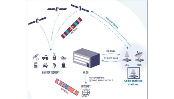
    The Galileo HAS relies on the robust infrastructure already established within the Galileo system. At the foundation of this network are the Galileo Sensor Stations (GSS), a global network of 15 monitoring stations (according to the latest updates). These stations play a vital role by continuously collecting GNSS measurements, which serve as the raw data needed to generate precise corrections. The collected data are then processed by the High Accuracy Data Generator (HADG). This system analyzes the GSS input and produces high-precision corrections for both Galileo and GPS signals. Once the corrections are prepared, they are transferred to Uplink Stations (ULS), which transmit the correction data to the Galileo satellites for distribution via Signal-in-Space, or to an NTRIP caster for distribution over the Internet. In the case of Signal-in-Space distribution, the Galileo satellites themselves serve as the delivery mechanism to users worldwide, broadcasting the corrections globally via the E6-B signal. 

    Galileo HAS high-level architecture. (Credit: Galileo High Accuracy Service (HAS) Info Note”. © European GNSS Agency, 2020)
    Galileo HAS high-level architecture. (Credit: Galileo High Accuracy Service (HAS) Info Note”. © European GNSS Agency, 2020)

    Galileo HAS Roadmap 

    The HAS is being rolled out in three phases, ensuring progressive development and refinement: 

    Phase 0 (2020–2022): Internal Testing 

    • Focused on validating the feasibility of broadcasting HAS corrections via the E6-B signal. 
    • Tests involved internal and external stakeholders, with feedback used to refine the service. 

    Phase 1 (January 2023–Present): Initial Service 

    • Declared operational on January 24, 2023, Phase 1 provides Service Level 1 with global coverage, though with reduced performance compared with the enhanced Service Level 1 expected in Full Service (Phase 2). 
    • Current corrections include orbits, clocks, and code biases. 
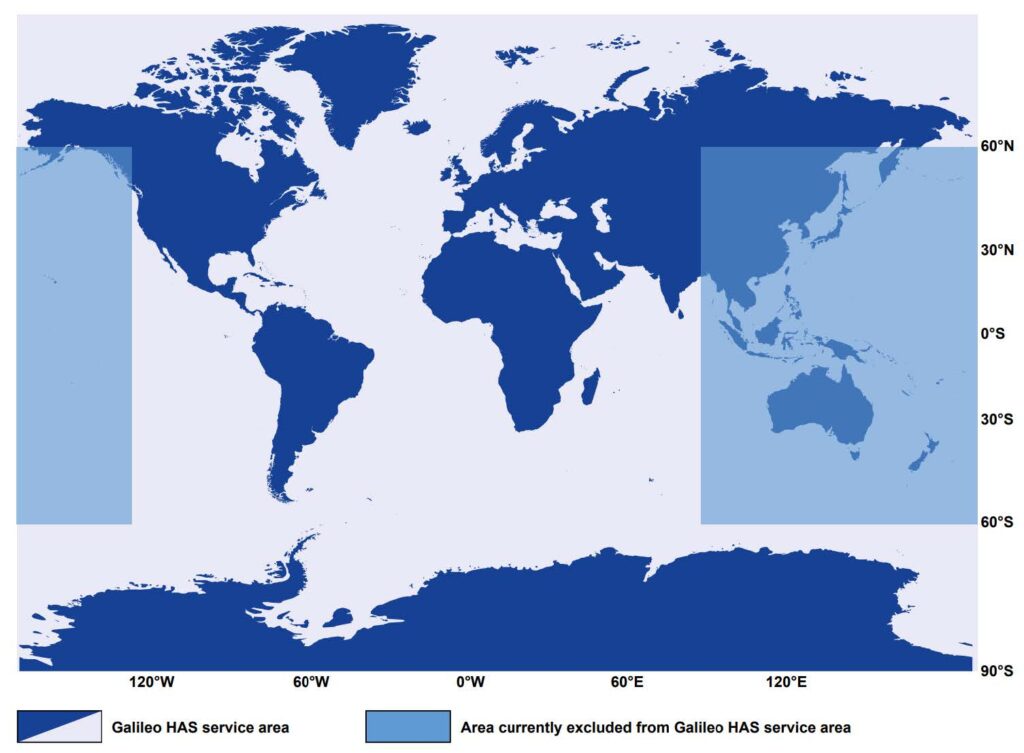
    • The service area excludes certain regions (e.g., parts of the Pacific and Australia) because of infrastructure limitations. 
    • Convergence time is specified as <300 seconds (Service Level 1) or <100 second (Service Level 2), with horizontal accuracy <20 cm and vertical accuracy <40 cm under optimal conditions. Currently, accuracy <20 cm may be achieved with a convergence time up to 60 minutes, owing to the lack of phase bias and atmospheric corrections. 

    Phase 2 (Future): Full Operational Capability 

    • Will provide full Service Level 1 performance globally with horizontal accuracy <20 cm and vertical accuracy <40 cm, adding phase bias corrections for faster convergence <300 seconds. 
    • Will introduce Service Level 2 for regional coverage in Europe with horizontal accuracy <20 cm and vertical accuracy <40 cm, adding phase bias and atmospheric corrections for faster convergence (<100 seconds). 
    • Will include data authentication and enhanced infrastructure for improved reliability and coverage. 

    Challenges and Limitations 

    The current capabilities of Galileo HAS are constrained by several limitations, which are expected to diminish as the system evolves. Global coverage is not yet fully established, with parts of the Pacific region and Australia remaining outside the service area. While users can receive HAS corrections anywhere in the world, the official performance specifications apply only within the service boundaries. However, even within the service area, achieving the specified accuracy presently requires long convergence times, limiting applicability in scenarios that demand rapid solutions. Convergence time is expected to decrease significantly in Phase 2, when phase bias and atmospheric corrections are introduced. 

    As of 2025, relatively few commercial receivers support HAS corrections via E6-B, with availability concentrated in professional and industrial receivers. The lack of integration into mass-market devices limits broader adoption, reflecting both the technology’s ongoing development and the additional hardware complexity required to receive HAS corrections. 

    Finally, while decimeter-level corrections are sufficient for a wide range of applications, many professional domains, such as surveying, demand cm-level accuracy. Even at Full Service, HAS will not provide this level of precision, meaning that certain fields will continue to rely on RTK. However, considering that most RTK vendors require a paid subscription or charge per hour, HAS can still provide great value to surveyors and other professionals through its use in preliminary work or applications where cm-level accuracy is not critical, offering decent accuracy free of charge. 

    Galileo HAS service area. (Credit: Source: “Galileo High Accuracy Service Definition Document (HAS SDD), Issue 1.0” © European Union 2023.)
    Galileo HAS service area. (Credit: Source: “Galileo High Accuracy Service Definition Document (HAS SDD), Issue 1.0” © European Union 2023.)

    The Road Ahead 

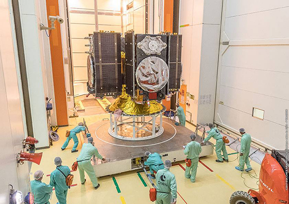
    The Galileo constellation was recently reinforced with satellites 31 and 32, which became operational in January 2025, while the ground segment underwent major upgrades in 2024. Despite these improvements, Phase 1 (Initial Service) remains the only operational HAS capability. As of September 2025, Phase 2 remains in active development. In January 2025, it was announced that the European Union Agency for the Space Programme (EUSPA) awarded GMV a 45-month, €12 million contract to develop an enhanced HADG that will support enhanced Service Level 1 globally and Service Level 2 for Europe. The contract’s duration provides an indication of the anticipated timeline for completion. 

    An inquiry regarding the timeline for Galileo HAS Service Level 2 (Phase 2) was submitted to the European GNSS Service Centre (GSC) Helpdesk. Their reply stated that the schedule is not available at this time and will be announced through GSC channels once released. 

    Wider adoption is anticipated as more GNSS receivers capable of receiving and decoding the E6-B signal to process HAS corrections become available, enabling sectors such as autonomous transportation, fleet management, and smart agriculture to capitalize on improved performance. Adoption is also expected to accelerate when Galileo HAS reaches Full Operational Capability with the launch of Phase 2, which will reduce convergence times and broaden the system’s applicability. 

    Ultimately, Galileo HAS is positioned to become a cornerstone of high-accuracy GNSS, democratizing access to professional-grade precision. 


  • MyGalileoDrone competition seeks UAV innovations

    MyGalileoDrone competition seeks UAV innovations

    The European GNSS Agency (GSA) has launched the MyGalileoDrone competition.

    The contest targets the design and development of drone-based applications or services, using a Galileo-enabled receiver, to address the European Union’s (EU’s) key priorities such as the Green Deal, and support the EU Recovery Plan for Europe.

    Initial ideas should be submitted by Aug. 31. Wide participation from all EU Member States is expected.

    According to ESA, the MyGalileoDrone competition seeks to tap into the EU’s innovative spirit to deliver applications and services to boost Europe’s competitiveness, resilience and sustainability. Applications should leverage and demonstrate Galileo’s added value, such as increased accuracy, availability and robustness of position, as well as integrity for a solution based on drone operations.

    Drones applications

    Photo: © GSA
    Photo: ©GSA

    The market related to drone applications and services is growing rapidly, and European drone service revenues are expected to reach EUR 250 million by 2025. The European demand is estimated to reach EUR 10 billion annually, in nominal terms, to 2035 and over EUR 15 billion annually to 2050, creating more than 100,000 jobs.

    With GNSS receivers implemented on almost all new commercial drones, Galileo’s and EGNOS’ added value is pivotal for the development and growth of drone services and applications.
    In addition to designing and developing the application, contestants should prepare their drone- based application or service for commercial launch.

    The solution should leverage Galileo to provide a position fix. The use of EGNSS is understood in the broad sense, and Galileo can be integrated in the flying platform, the ground control station, or in other devices supporting the operation, such as a smartphone or even in the frame of U-Space services.

    “GNSS is a key enabling technology in this segment, ensuring robust navigation and reliability for a wide range of applications. The MyGalileoDrone competition aims to bring oxygen to European SMEs and entrepreneurs driving innovation. It will create jobs and growth in this promising market,” said Pascal Claudel, acting executive director at the GSA.

    Focus on EU priorities

    In times of post-COVID recovery focus, submissions should target applications and services that support key EU priorities, but the sky’s the limit. The GSA is looking for trailblazing ideas in applications such as smart mobility, sustainable agriculture or environmental protection, or solutions that exploit synergies between 5G and space data, or support the internet of things, or whatever might be the next big thing.

    Deadlines and Prizes

    The first prize in the MyGalileoDrone competition amounts to EUR 100,000, with EUR 60,000 for second, EUR 40,000 for third, and a fourth prize of EUR 30,000.

    After Aug. 31, projects selected to advance to the development phase of the contest will be announced on Sept. 15. Participants will  have until Nov. 30 to develop a demo version of their proposed application or service.

    In the finals, the selected teams will perform a live demonstration and pitch their ideas to investors. During the development process, the applicants will receive mentoring and coaching from recognized experts in the drone market. These experts will accompany them as they build their application, develop tests and get ready from the business perspective to attract investors and move to market.

    To register or for more information, visit the competition page on the GSA website.

  • EU contracting for GNSS interference detection network

    Request for proposals to be issued

    The Official Journal of the European Union (EU) will publish a funding opportunity in the near future for a GNSS “Advanced Interference Detection and Robustness Capabilities System,” according to officials familiar with the project.

    Advance notice of this procurement was first given in August of last year, with an award projected for the first quarter of 2019. Some observers have speculated that the procurement delay was related to a change in how the final system is envisioned. The current version of the notice asks for a crowdsourcing, software and networked-based solution.

    The advance notice calls for the vendor to both establish the system and operate it.


    The purpose of the present tender is to establish a new mechanism to detect interference at receiver and antenna level based on crowdsourcing and sharing information coming from any user (individuals or associated ones) and run the service for a period of two years.


    While for many “crowdsourcing” suggests the participation of large numbers of individuals, this will likely not be part of the scheme. Speaking to a government advisory board, Jean Yves Courtois, CEO at Orolia, said that battery drain on cell phones would prevent this from being practical. “Privacy concerns would also be an issue,” he said. Each individual would have to affirmatively agree to have their location information used continuously. This additional administrative burden would be significant.

    Much easier and preferable would be using Information from already deployed networks of fixed receivers, such as base stations. Unchanging locations and existing network connections make the engineering easier and thorny privacy concerns would be minimized. These ideas are also reflected in the current version of the advance notice:

    The activity shall also focus on identifying and engaging users (such as entities currently monitoring vast networks of devices integrating GNSS receivers) by means of an appropriate enrolment scheme ensuring the provision of the data. The design of the system shall ensure that the sensitivity of the data (GNSS vulnerabilities) is always protected.

    Crowdsourcing and collating such information is seen by many in industry as a relatively straight-forward engineering problem. Representatives from Orolia and Microsemi, for example, included ideas about crowdsourcing disruption data in recent presentations to the U.S. PNT Advisory Board. Both agreed, though, that there are few commercial incentives to do such work without a government customer.

    It is perhaps not a surprise that the EU is taking the lead in this field while other GNSS providers seem to have little interest.

    Unlike GPS, GLONASS and BeiDou, which are first and foremost national security systems, Europe’s Galileo was built and is operated by a civil organization focusing on economic and civil benefits. Interference with signals directly undercuts these benefits and can be easily seen in direct economic costs.

    Many European countries are using GNSS for road tolling, for example. Small GNSS jammers are easy to acquire off the internet and their illegal use is likely costing nations millions of euros in lost tolls each year. Without the ability to regularly detect, sanction, and deter this activity financial losses will continue to mount.

    The interference with tolling problem is not specifically addressed in the EU’s advance notice. It may well be that tolling authorities and others will be expected to install their own application specific interference detectors and then encouraged to link them to the EU backbone and database.

    The European Commission has been aware of this vulnerability for some time. In 2015 it contracted with Nottingham Scientific Ltd. in the UK to lead a multi-nation team and assess the extent of the problem.

    The STRIKE3 project was in operation from February 2016 to January 2019. Its goals were to sample and classify interference events, recommend a standard event reporting scheme, and assess the vulnerability of different types of GNSS receivers.

    The project’s sampling activity in 23 different countries detected nearly 500,000 interference events. Of these, 59,000 were classified as deliberate attempts to disrupt GNSS signals.

    Within the deliberate events the STRIKE3 team were able to identify about 300 jammer “families,” according to Mark Dumville, Co-Founder and Director at Nottingham Scientific. Along with the jammers they were able to classify into groups, there were “some very interesting outliers,” Dumville said. “These are likely evidence of jammer technology continuing to develop and evolve.”

    STRIKE3 is viewed as a very successful project by most everyone in the international PNT community, and certainly within the EU, according to officials.

    The upcoming announcement and future establishment of an on-going interference detection capability are some of the next logical steps to better securing Europe’s PNT services.

  • With Brexit looming, EU and UK tangle over Galileo

    An increasingly bitter political and economic argument between the United Kingdom (U.K.) and the European Union (EU) has alternately stalled and unfrozen progress on Galileo.

    Why does this matter from a defense and security viewpoint? Because it’s all about access to Galileo’s Public Regulated Service (PRS), the military-grade service and signal — in addition to billions of pounds and euros.

    The byzantine maneuvering on both sides may have further implications, in the form of a much-expanded role for the current European GNSS Agency (GSA), with a corresponding reduction in funding scope for the European Space Agency (ESA).

    ESA is not directly affected by the Brexit brouhaha, but indirectly, the impacts mount and extend. ESA is technically independent of the EU, but acts as the union’s procurement body for space programs. It is run by the 22 member states on the ESA council — which crucially includes the U.K., as well as non-EU members Norway and Switzerland. Thus, the Brits, while exiting the union in March 2019, will continue to play a voting role in the space agency.

    In an second-round gambit, the U.K. had threatened to use its veto on the ESA council to delay procurement of future Galileo satellites. This was seen as an attempt to bring the EU into negotiations over U.K. access to the highly encrypted Galileo PRS.

    A navigation and timing signal restricted to use by authorized government agencies, armed forces, police, emergency and other security services, the PRS is designed to be robust to jamming and spoofing and available even in times of crisis.

    Under EU rules, only EU member states can access or work on the PRS. Similar to GPS M-code, PRS could be said to be the prime motivating factor for the origins of the European GNSS: the desire, some would say the compelling requirement, to have a military-grade signal under one’s own control.

    The U.K. says it will encounter “significant gaps” in a wide range of areas including prisoner transfers, asset recovery, sharing of financial intelligence, victim compensation and access to criminal records for child protection vetting, should it be shut out from the PRS. This doesn’t begin to reveal the real reason: the ability to conduct military, security and defense operations confidently undertaken with a secure and enrypted GNSS signal.

    The European Commission maintains that the U.K. will have to “apply” to use the PRS, like any other non-EU country, tacitly as a “foreign entity.” PRS is for EU member states only.

    U.K. companies such as CGI U.K. have developed much of the programming and coding of the PRS signal. Current EU rules bar all U.K. companies from bidding on new contracts unless they transfer their work to EU countries before Brexit. The EU wants CGI U.K. to hand its encryption security intellectual property to the Franco-Italian firm Thales Alenia Espace.

    This would poke Britain’s defense ministry where it hurts most: access to the key source codes, and a measure of security in military, defense and police operations. The U.K. government also wishes to retain the encryption expertise and personnel, rather than see them outsourced.

    Four Galileo satellites placed in the payload container prior to December 2017 launch, which brought the total Galileo constellation to 22. (Image courtesy of ESA)

    Whither GSA?

    In a separate but closely related debate within the EU, a strategic repositioning is proposed for the GSA: renaming and remaking it into the EU Agency for the Space Programme. This would not only greatly enlarge its sphere of activity and authority, it could create two sparring space agencies in Europe, one wholly under the control of the EU and one with the maverick U.K. on its ruling council.

    A draft EU document states ESA’s decision-making procedures “cannot lead to a call into question of the decisions of the [European] Commission or the European Space Agency within the framework of the actions and space programmes of the union.”

    ESA is naturally bitterly opposed to its parent organization creating a rival. It has long struggled — behind closed doors — with its semi-independent, semi-subservient role to the EU, which after all holds the ultimate purse strings.

    Some in Europe see indications that the GSA rebadging could lead to a gradual transfer of space funding from ESA to the newly rechristened agency if EU discontent rises. “A creep in power” was the term used by one official.

    The EU has long expressed concerns over ESA’s governance of the funds handed to it by the EU for space projects. The long stall in Galileo getting up a full head of steam, a period that could be said to have extended from 2002 to 2008 or thereabouts, was seen by some atop the EU as evidence of ESA over-extension: technically expert but fiscally untrained or unqualified.

    Opening Salvos

    In what now appears to be a dead issue, the U.K. had first demanded reimbursement for the €1 billion it contributed to Galileo. The EU rejected that out of hand, saying it would not negotiate “under threat.”

    In a follow-up, the U.K. claimed that while it wished to continue participating in Galileo, it could well start up its own GNSS if it did not receive adequate access to Galileo PRS. The EU stuck to its guns, so to speak: “Third countries [and their companies] cannot participate in the development of security-sensitive matters.”

    The U.K. has also bruited blocking Galileo from use of ground tracking stations in British overseas territories, such as the Falklands.

    A U.K. minister stated: “The U.K. genuinely wants to remain a major player in the project, with privileged ongoing access from outside the EU, and views its capabilities and contribution to date as giving it the right to that ticket.”

    A European spokesperson countered: “For the EU, the decision to leave inevitably entails relegation to a different role and status in the project, and, let’s be candid, offers scope for EU-located firms to take contractual business away from U.K. ones.”

    Oh, what a tangled web these mortals weave.

  • Brexit fallout: Galileo center moves from UK to Spain

    Brexit fallout: Galileo center moves from UK to Spain

    A security center for the European Union’s Galileo satellite system will be moved from the United Kingdom to Spain as a result of Brexit, according to numerous press reports.

    A committee of representatives of member states voted by a large majority on Jan. 18 to approve the European Commission’s recommendation of Madrid as the Galileo Security Monitoring Centre’s (GSMC’s) new home.

    The center, which is not yet fully operational, has only one full-time member of staff in Swanwick, England, but when it is up and running in Madrid, staffing is expected to grow to as many as 30.

    The center controls access to the satellite system and provides around-the-clock monitoring when the main security center near Paris is offline.

    The European Commission’s decision to move the center to Spain will bring Spain “strategic advantages, industrial development of high technological value, and the consolidation of national knowledge and technology in the area of security,” the Spanish ministry of public works said.

    Spain was selected from six countries, according to Spanish media. It offers the facilities of the National Institute of Aerospace Technology (INTA), which belong to the defense ministry and are located in Madrid.

    The GSMC is operated by the European GNSS Agency (GSA) in charge of supervising and acting on cases such as security threats and alerts.

    Spain has another of the fundamental centers of the program, the Loyola de Palacio GNSS Service Center, also located in Madrid.

    The center is one of a number of EU institutions leaving the UK as a result of the 2016 referendum vote, also including the European Banking Agency, which is relocating to Paris, and the European Medicines Agency, which is going to Amsterdam.

  • Project to advance multi-GNSS development uses Spirent test systems

    Project to advance multi-GNSS development uses Spirent test systems

    Spirent Communications’ testing systems are being used by the European Union TREASURE project (Training, REsearch and Applications network to Support the Ultimate Real-time high-accuracy EGNSS).

    The aim of the four-year project is to provide instantaneous and high-accuracy positioning anywhere in the world, exploiting different satellite systems operating together to provide users with positional accuracy of a few centimeters.

    Spirent’s GSS7000 test system.

    By 2020 Galileo, the European GNSS system (EGNSS), will be fully operational and provide positioning data of unprecedented accuracy. Galileo’s integration with other satellite systems through the TREASURE project is key to increasing Europe’s competitiveness in the field, which has been mainly based on the GPS system in the past 20 years.

    Higher accuracy services will not only assist safety-critical industries such as air and maritime navigation services, but also help industries such as the global agri-tech market, autonomous vehicles and capital-intensive sectors.

    Kimon Voutsis, Robust PNT Solutions Architect, works on a professional services project for a client.

    For example, more accurate real-time positioning data can assist farmers in maximizing food production, reducing costs and minimizing the environmental impact. Equally, a deep-sea drilling platform that experiences any temporary degradation in positioning accuracy could lead to significant financial losses.

    “Spirent is proud to support multi-national initiatives that advance our industry and provide better end user performance,” said Martin Foulger, general manager of Spirent’s positioning business unit. “More systems are using GNSS data, and users always want better accuracy, so TREASURE will help to provide this.”

    TREASURE is an EU-funded project under the H2020-Marie Skłodowska-Curie Innovative Training Network. It is coordinated by the University of Nottingham, and Spirent is the partner providing GNSS simulation systems.

    For more information on Spirent’s GNSS testing solutions, visit the website. To learn more about how to test receivers of GPS, Galileo and other GNSS, download Spirent’s eBook.

    To learn more about TREASURE, contact Marcio Aquino, Nottingham Geospatial Institute.

  • Emergency 112 calls in Europe saving lives with GNSS

    Emergency 112 calls in Europe saving lives with GNSS

    On Feb. 11, the European Union (EU) celebrated 112 Day in honor of the single European emergency phone number. The 112 system uses Advanced Mobile Location (AML) to receive location information from mobile phones.

    112_map_EU-location-W
    Photo: 112 SOS

    Every year, about 300,000 people who call the emergency services cannot describe their location because they may not know where they are, because they are too young to say or they are too injured to communicate. In these situations, knowing the exact location of the caller can help emergency services react quickly and save lives, according to the European Commission.

    Europeans can dial 112 for free in any EU country if they need to contact emergency services, thanks to EU legislation introduced in 1991. Today’s mobile and smart devices are able to provide emergency services with accurate caller location via an SMS or data channel using GNSS or Wi-Fi capabilities.

    An EU-financed project — HELP 112 — looked into how GNSS can improve caller location using the AML solution. It was tested in the United Kingdom, Lithuania, Italy and parts of Austria.

    A new report shows significant improvement for caller location in several EU countries. Lithuania upgraded its network-based location solution to ensure significantly more accurate caller location. The United Kingdom and Estonia deployed the AML handset-based caller location solution that can locate a person to within 100 meters.

    Currently, AML handset-based caller location for emergency services is available only on Android phones.

    Life-saving assistance

    (Photo: North West Air Ambulance/Flickr)
    (Photo: North West Air Ambulance/Flickr)

    The system has already saved lives. On Jan. 10, an emergency call was received by the Klaipeda Public Safety Answering Point in Lithuania. The caller was an 8-year-old boy who reported he had found his father unconscious or dead, probably struck by electricity. He told the operator that he didn’t know his address or the telephone number of any of his relatives.

    Although the boy unaware of his address, cell-ID location information received by the emergency services had a radius of 14 kilometers. Fortunately, around one minute after the call was received, the operator received the location via Android Emergency Location (Advanced Mobile Location), with a radius of 6 meters.

    The police and ambulance services were dispatched, and emergency responders provided acute medical care to the man who had suffered an epileptic seizure.

    In Austria, a woman riding a horse fell on her head and was unable to describe where she was. GNSS provided emergency services with her exact location within seconds, so she could be rescued.

    Galileo increases accuracy

    “Satellite navigation is crucial in determining the precise location of the 112 caller and saving lives,” says Commissioner Elżbieta Bieńkowska, responsible for internal market, industry, entrepreneurship and SMEs. “Galileo, Europe’s own satellite navigation system, will be able to locate the caller with much greater accuracy. The launch of Galileo’s initial services and first Galileo smartphones available on the market show how space data is making a difference in daily lives of EU citizens.”

    In addition to funding research, the commission is also improving EU rules on 112. In September 2016, the commission proposed an update of EU telecom rules in the form of an Electronic Communication Code. The commission wants to enhance the relevant provisions of the Universal Service Directive to facilitate the use of handset-based caller location as complement to network-based location data.

    According to the proposal, member states will be obliged to ensure that caller location, be it network based (provided by the mobile operator) or handset based (retrieved from a GNSS or Wi-Fi enabled phone), arrives in a timely manner to the public safety answering point that handles emergency calls.

    Whichever technology is used, caller location will be free for citizens and the public safety answering points.

  • Europe enters ‘The Year of Galileo’

    2016 has already been dubbed as “The Year of Galileo.” That was the clear message from the Munich Satellite Navigation Summit in early March. The Munich summit covers all GNSS systems, but the focus this year was squarely on Galileo.

    I think it is fair to say that come hell or high water we will see Galileo Initial Services debuting in October 2016. Representatives from all parties to the Galileo initiative – the European Commission, ESA and GSA – stressed the importance of getting those first services in place.

    12 satellites currently in orbit (despite one being definitely broken and two in sub-optimal orbits) will be sufficient to deliver the service, and this will not depend on any of the six satellites to be launched during 2016. Extensive system testing will take place during the spring and summer to ensure all is ready.

    The Munich Satellite Navigation Summit 2016

    Watching the traditional high-level opening plenary session in Munich’s marvellous Allerheiligen-Hofkirche (Court Church of All Saints), it is clear that a more collaborative era has entered the European GNSS scene. The body language of the various European parties on stage was so much more relaxed than at previous summits. For me this is the good news that Johann-Dietrich “Jan” Woerner has brought as the new Director General of ESA.

    The working title of this 13th Munich Summit was “GNSS — creating a global village” but the focus was squarely on Galileo. From the European Commission, Pierre Delsaux thanked Jan Woerner for shuffling the ESA launch schedule to enable the extra Soyuz launch for two Galileo satellites in May and anticipated global coverage by 2020. He also emphasized the need to show value for EU taxpayers and unleash space-based services, new applications and jobs for global citizens. It was also confirmed that Galileo launches were now insured.

    Deliver, deliver, deliver

    Jan Woerner himself praised the collaboration with the Commission, saying during the panel discussion that there was “no power struggle at all.” He said that the Director General of the Commission’s DG GROWTH, Lowri Evans, had the motto: “Don’t discuss: deliver, deliver, deliver.” He agreed that the roles of the various players needed refinement but this should never be to the detriment of the Galileo programme.

    Carlo des Dorides, Executive Director of the GSA, was also optimistic. He said GSA is now taking its full place in the GNSS world. He focused on what Galileo will bring to the Internet of Things (IoT), and digital infrastructure in general, and emphasised the better accuracy and availability of the European GNSS, especially in urban-canyon  environments, and also its proposed authenticated open signal. “The (Galileo) revolution is an appointment that cannot be missed for success in digital infrastructure,” he concluded.

    Higher levels of authentication and trust that are to be provided by Galileo signals give the appearance of a distinct market differentiator for the system. Most importantly, one that the market and applications in mobility, finance and the IoT want to see.

    The Jewel in the Crown

    Later in the summit Imogen Ormerod, Head of Galileo Policy at the UK Space Agency, described the Galileo Public Regulated Service (PRS) as the “Jewel in Galileo’s crown.” insisting that PRS was unique and that the ability to have confidence in the signal would be ground-breaking. Done right, PRS has “unique and unchallenged commercial potential,” she concluded.

    As provision of authentication is clearly not on the civil GPS horizon at the moment, “unchallenged” appears to be the appropriate word.

    During a session on authentication, Harold “Stormy” Martin, Director of the National Coordination Office for Space-Based Positioning, Navigation, and Timing in Washington, stated that the United States has no plans for civil authentication in the current-generation GPS satellites or in GPS III. However, he said the U.S. was interested in EU developments and would continue to explore possibilities for future.

    Next Generation

    Paul Flament, Head of Unit for Galileo and EGNOS – Programme Management at the European Commission issued further warm feelings for Galileo on the Wednesday morning. His update on Galileo status  confirmed the news hinted previously that the two Galileo satellites delivered into the wrong orbits will be used for the Galileo Search and Rescue function and would probably also be available for the Open Service. Testing with receiver manufacturers has already shown that their signals are compatible.

    He also talked about the new tender for eight further satellites that has been issued by the Commission. This would procure the four extra satellites now needed to reach a 30-satellite constellation and four for spare. The winning bidder could be known by September and definitely by the end of the year.

    Commission rules require that a contract of this size must be put out to tender, but as the satellite specification is pretty much identical to that now being successfully rolled off the OHB production line, it would be bizarre — although not beyond the mystery that is EU space politics — for the tender to be awarded anywhere else.

    The GSA competition to select the operator of Galileo services will also be known by the end of 2016. Consultation on what will be required for the second generation of Galileo FOC satellites beyond 2020, perhaps with an emphasis on cost reduction, will open sometime this year.

    EGNOS over Africa

    The potential extension of the European SBAS EGNOS over Africa was discussed in a session that emphasised the global village dimension of GNSS. Julien Lapie from the Agency for Aerial Navigation Safety in Africa and Madagascar (ASECNA), based in Dakar, gave an update on the programme that is looking to establish a cooperative management system of a single sky of over 16.1 million square kilometres — around 50 percent larger than Europe.

    ASENCA is developing a programme and resources for deployment of EGNOS in Africa with the objective of African ownership of the infrastructure, control and provision of a signal-in-space and autonomous provision of services to users. A first step was to provide early EGNOS-based services by 2019/20, and then provision of full services from 2023 onwards. One technical issue had been the need for more and better information on ionospheric effects over Africa to characterise and optimise the EGNOS model for SBAS. Results here were very encouraging, and Lapie said that this was no longer a problem for L1 service on SBAS. He hoped for an ASECNA-EU international agreement as soon as possible. Such a system will need a space-based component and this will have to be subject to an open tender, Lapie told me after his presentation.

    On obvious contender for the tender is already in orbit: NigComSat-IR. John A. Momoh of the Nigerian National Space Research and Development Agency described the characteristics of this satellite that was primarily launched to provide communications services but also carried L1 and L5 transponders designed for SBAS. These had been commissioned and showed “close to GPS performance and a signal in space that is compatible with GNSS.” Momoh said that the satellite could be a core component of an Africa SBAS.

    Time gentlemen – please!

    One new potential wrinkle for Galileo was hinted at during the Munich session on legal issues around GNSS timing. A recent GPS timing issue caused numerous problems for digital broadcasters and financial networks around the world on 26 January, when a data upload went slightly awry. This introduced a 13.7 millisecond error in one of the timing signals: the static offset for GPS time compared to Coordinated Universal Time (UTC). It led to some receivers exhibiting “different and unwanted behaviour” – a very polite description!

    Fortunately the issue was resolved swiftly, and correct data uploaded. The extent of any financial losses and how any legal proceedings (if any) to recover damages might pan out are still unclear. However what is clear is that while GPS time has a clear link to legal time, Galileo does not. Dr. Andreas Bauch from the German Physikalisch-Technische Bundesanstalt (PTB) — one of Germany’s “Time Lords” — described the underlying legal basis of GNSS time.

    U.S. GPS time is traceable and legally defined to national time and UTC through the National Institute of Standards and Technology (NIST). In Europe most Member States, but not all, have legal time defined in legislation. Galileo System Time (GST) is not linked to a single institution but to an average derived from a network of European standards institutions including PTB. From the presentations it was not clear to me if GST currently has a water-tight legal definition.

    Talking to legal and technical experts after this session, it became clear that the legal basis for GST does need to be clearly defined in European legislation — and soon — if Galileo PNT services are to be a commercial reality in the near future. The Commission needs to get on the case for this one pronto.

    Tracking Everything

    On a lighter note I had great pleasure in chairing a GPS World session at the Summit on the final day with the title of “‘GNSS and Sciences for Life.” This small but perfectly formed session presented three different applications of GNSS used to track people, animals and assets. Walter Naumann of the Max Planck Institute for Ornithology showed, via a series of videos, his remarkable work in the ICARUS project tracking the migration of animals from locusts to elephants via a payload on the International Space Station. GNSS tags that weigh 5 grams or less enable accurate tracking of even the smallest beast.

    Stefan Thurner of the Institute of Agricultural Engineering and Animal Husbandry in Freising, Germany described his use of GNSS tags to track cattle and other farm animals in alpine summer pastures, enabling farmers to monitor their herds from a distance. Finally Oliver Trinchera of Kinexon told us about developments at this Munich-based winner of the 2013 Galileo Masters competition. Kinexon technology is used to track people and assets worldwide and has its own proprietary solution for accurate indoor positioning providing a low-cost, scalable solution.

    In the same general field as Kinexon one of my favourite young companies — and also a winner at the 2013 European Satellite navigation Competition — Johan Sport has had a great March so far. The month marked the commercial launch of company’s EGNOS-enabled sports tracking products and the launch of a crowdfunding campaign via the Dutch Symbid site. The company was seeking € 150 000 to scale up production and hire a couple more employees. The new funding for 5 percent of the company’s shares values Johan Sport at two million Euros and was oversubscribed within four days! “We are indeed very pleased,” says CEO Jelle Reichert. “Now full throttle to the market!”

    The Johan Sport system is seen as the first affordable and reliable performance monitoring system for professional field sports. And with the global market for sports analytical equipment predicted to grow to some $4.7 billion by 2021, there is plenty to play for!

    Year of UAVs too?

    The unmanned aerial vehicle (UAV) sector is a dynamic GNSS-enabled sector globally, and Europe is no exception. In January I attended a UAV event at the Royal Military Academy in Brussels. The focus of the two-day meeting was on small commercial and recreational remotely piloted aircraft systems (RPAS) that are rapidly populating Europe’s airspace.

    Currently, there is no European legislation that governs their use in conjunction with general aviation and, typically, national legislation varies across the member states. Regulators are trying to play catch-up.

    One interesting EU project trying to tackle this situation is DroneRules.EU. Philippe Carous of SpaceTec Partners said the project’s main objective was to raise general awareness of the rules governing RPAS across the commercial sector and the general public. Speaking as an occasional drone operator – I own a Parrot 2.0 – I must admit I was oblivious of the legal minefield I am potentially entering every time I fly my ‘Boy’s Toy’ around the garden!

    The project covers three main areas: privacy and data protection; safety and operation; and insurance and liability. The plan is to establish a set of useful tools on a web portal including awareness, training tools and online resource covering rules at national level plus regulatory developments. The website should be available mid-2016 at http://www.drone-rules.eu.

    Rachel Finn of Trilateral Research, a partner in the DroneRules.eu project, talked about privacy and data protection issues which bring some complex rules and liabilities into play as drones are increasingly becoming data collection devices. The company undertook a survey of users for the European Commission and identified private users as the least regulated and most at risk of breaching the rules. Commercial users were seen as medium risk. “Using the same drone with the same payload in different contexts can raise different or new privacy and data protection issues,” Rachel said. Each mission may need to be individually risk assessed.

    Listening to the discussion here, it seemed to me that privacy issues could effectively turn any urban area into a ‘no-go’ zone for civil drones let alone other considerations on safety and so on.

    The Brussels conference was organised by UVS International whose president Peter van Blyenburgh is a blunt-speaking and passionate advocate for the civil RPAS operating community in Europe.

    On 4 March a further workshop took place at EUROCONTROL headquarters in Brussels with the purpose of discussing the future working arrangements and work programme for the development of RPAS standards. Peter van Blyenburgh tells me that not a single RPAS operator had been invited to air their views at this forum.

    From the discussions at the workshop it was clear, according to van Blyenburgh, that international, European and national standards organisations are not coordinating their work and consequently there is significant duplication and wasted effort. However it was decided that a single working group will be established to tackle standards work for all sizes of RPAS and terms of reference for this group should be finalised by the middle of June 2016.

    During the workshop  van Blyenburgh expressed his views on the absolute necessity that RPAS operators and new disruptive technology companies must participate in the work on standards and as there was a large number of light RPAS (<25 kilograms) already flying, it was also imperative to tackle the standards applicable to them as a priority.

    Van Blyenburgh takes the view that if the RPAS community is not careful and proactive, their commercial future may be set by standards produced by the traditional airspace players that are not directly involved with their specific community, nor really understand it. It is hard to disagree with his views here.

    “Of course, at the same time, the RPAS communities should both remember that airspace safety is a common responsibility that should be proportionately shared by all RPAS community members,” he adds. “Defining this proportionality will be one of the keys to success.”

    Polish solution?

    If regulations are lacking, technical solutions are ready to roll. One European initiative based in Poland seems to have a viable monitoring and control system developed for drones/ RPAS: The Drone Monitoring System (PSMD) was presented by Justyna Zdanowska of the Grupa Dron House S.A.

    The Polish solution can monitor drones in near real-time (the company claims a maximum delay of one second) using GSM and/or GPS technologies and has the ability to manage the drone online through an application. They say this is the first successful development of such technology that is operational and ready for implementation. It has already attracted the interest of some major aerospace players, drone users and the authorities as the system could solve the issue of uncontrolled flights and other problems.

    “We offer a complete, ready-to-use system that will radically improve the safety of air traffic, because the drone market is developing at a dynamic rate in an uncontrolled manner,” says Justyna Zdanowska.

    The technology also has a huge capacity with up to 18 000 devices controlled and/ or monitored by a single base station at a given location. This should allow full monitoring and identification of unmanned devices.

    2016 Masters

    Finally I am looking forward to the 2016 Galileo and Copernicus Masters competitions that will launch soon in Europe. These annual high-profile competitions showcase some of the best emerging applications and ideas for GNSS and Earth Observation in Europe, and globally.

    As mentioned above the ideas behind both Kinexon and Johan Sport won big at previous Masters events and the 2016 competition launches on 1 April. You can find out more, here.


  • European Space Solutions to feature Galileo and EGNOS

    European Space Solutions 2016 is a five-day conference that will bring together business and policy makers with users and developers of space-based solutions. The conference will take place at the World Forum Convention Centre in The Hague, The Netherlands, May 30 to June 3. Registration is free of charge, but mandatory.

    The event will explore how space makes a difference to the lives, and livelihoods, of people across Europe and around the globe. Space-based services and technologies are the future of efficient, effective and sustainable services that society needs, organizers said. The conference is presented under the auspices of the 2016 Dutch Presidency of the Council of the European Union.

    Participants will learn about new innovations that harness information from the European flagship space programs, Galileo and EGNOS (satellite navigation) and Copernicus (Earth observation), and the European Union’s Horizon 2020 research program, for a wide range of applications, gather insights about current developments and discuss what is possible and needed in the future.

    The conference will be accompanied by a range of dedicated focus sessions and side events, opportunities and more.

    European Space Expo

    The conference also will run in conjunction with the European Space Expo, which comes to The Hague, The Netherlands, May 28 to June 5.

    The expo presents information on European space programs ranging from satellite navigation (Galileo and EGNOS) to Earth observation (Copernicus) in an engaging and entertaining way. Highlights include the OmniGlobe — an interactive hologram of the earth’s atmosphere, an impressive model of a Galileo satellite, and many more.

    More than 900,000 people have already visited the European Space Expo as it continues its tour of major European cities. The free exhibition highlights the many ways in which European Union space programs help Europeans “on the ground” every day.

    The aim of the expo is to show citizens how European space policy and space-based technologies benefit their everyday lives on Earth and the importance of space technologies to the European economy and job creation.

    EuropeanExpo
    Photo: GSA

    The European Commission, with the strong collaboration and support of the European GNSS Agency (GSA), launched the European Space Expo in 2012. The popular, interactive and free exhibition illustrates the many services and applications that come from the European flagship space programs.

    Free to the general public, record attendances have greeted the expo throughout its tour. 2016 is the fifth year of the highly successful road show, which has already visited cities from London to Larnaca and Rome to Riga. The expo was most recently in Luxembourg City, Luxembourg, Oct. 16-25, 2015.

    Follow the expo on Twitter at #euspaceexpo.