The European Union Agency for the Space Programme (EUSPA) has announced that as of June 1, the latest European Geostationary Navigation Overlay Service (EGNOS) payload is operational ahead of the first V3 test signals.
Launched onboard the EUTELSAT Hotbird 13G satellite in November 2022, the payload underwent a rigorous testing phase before entering service. It is expected to have a 15-year life span.
EGNOS V3 will augment both GPS and Galileo in the L1 and L5 bands. It is also set to provide additional satellite-based augmentation system (SBAS) service capabilities through a new SBAS channel on L5 and will deliver increased EGNOS service availability within and beyond the EU, supporting a growing number of users.
Aviation has benefitted greatly from the EGNOS safety of life service. This has enabled better access to small and regional airports, increased safety, and facilitated more sustainable flight routes across Europe. Other industries, such as maritime and rail, also benefit from the EGNOS safety of life service.
In addition, with its Open Service, EGNOS increases the positioning accuracy for other land-based applications including precision farming, geomatics and land management.
About EGNOS
EGNOS is Europe’s regional SBAS. It is used to improve the performance of GPS and will augment Galileo from 2025 onwards. EGNOS was deployed to provide safety of life navigation services to aviation, maritime and land-based users.
The information provided by EGNOS improves the accuracy and reliability of GNSS positioning information while also providing a crucial integrity message. In addition, EGNOS also transmits an accurate time signal.
By Juan Vázquez, Elisabet Lacarra, Jorge Morán and Miguel A. Sánchez, ESSP SAS, and Julian Rioja and Jimmy Bruzual, Topcon Agriculture
The European Geostationary Navigation Overlay Service (EGNOS), a satellite-based augmentation system (SBAS), provides corrections and integrity information to GPS signals over Europe and is fully interoperable with other SBAS such as North America’s WAAS. Among its services is the internet-based EGNOS Data Access Service (EDAS).
EDAS gathers raw data from GPS, GLONASS and EGNOS GEO satellites collected by receivers at approximately 40 EGNOS ground stations distributed over Europe and North Africa. EDAS reformats and disseminates GNSS data in real time and through an FTP archive to EDAS users and service providers.
Additionally, EDAS provides differential GNSS corrections to the GPS and GLONASS satellites in view by the EGNOS system network through its Ntrip service.
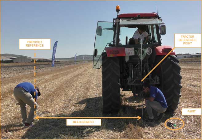
The tests summarized in this article focused on the EDAS Ntrip Service, which can be used for differential positioning. An earlier test near Seville, Spain, concluded that these corrections could support pass-to-pass accuracies in the order of 20 centimeters in a consistent manner and with a high degree of repeatability.
To assess EDAS performance validity for agriculture applications, two additional tests were done in Lisbon, Portugal, and York, UK. These locations provide diversity with respect to the Seville test, especially in terms of distance from the farm to the selected EGNOS reference station (≈320 km in York and 40 km in Lisbon, versus the 110 km baseline of the test in Seville) and also geographically. In all tests, a real-time kinematic solution operated in parallel to the EDAS DGPS solution to provide the required reference for the post-processing of the recorded data. Nine different runs with a total of 78 passes were performed in these two campaigns.
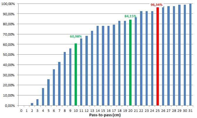
Considering the results from the three tests, the pass-to-pass accuracy supported by EDAS DGPS corrections was below 10 cm for more than 60% of passes and below 20 cm for more than 85 percent of the passes. These figures exceed the earlier results and confirm that EDAS DGPS corrections can deliver pass-to-pass accuracies in the order of 10 to 20 cm in a consistent manner.
Cumulative distribution of P2P accuracy, in centimeters. (Chart: Topcon)
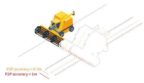
The stability of the results and the very good pass-to-pass accuracy levels observed in the York scenario, where baselines larger than 300 km were tested, deserve highlighting. For grain and dry soil cultivation, at least 1 meter (95th percentile) of absolute horizontal accuracy is required. It can be assumed that, within the area where EDAS DGPS supports sub-meter horizontal accuracies (up to 260 km from the selected EGNOS station, according to previous studies), EDAS DGPS corrections can also support pass-to-pass accuracies in the order of 10-20 cm.
Such performance levels are considered to be appropriate for most grain farm operations. In particular, the observed performance is sufficient to support the following precision agriculture applications:
If you’ve taken a flight in Europe recently, then the chances are growing that you’ve been a pioneer EGNOS user. Satellites in orbit would have guided your airliner’s descent, rather than signals beamed from the ground. You wouldn’t have felt any difference — except for possibly a smoother ride.
Cockpit of a new EGNOS-equipped Airbus 350 XWB, on show during the inaugural EGNOS Day at Toulouse-Blagnac Airport on May 7, 2015. (Photo: ESA)
More than 180 European airports have now been certified to make use of the ESA-designed European Geostationary Navigation Overlay Service — EGNOS — for approaches to given runways. This includes approaches at major hubs such as Paris Charles de Gaulle, Frankfurt and Amsterdam Schiphol. Thanks to EGNOS, safe landings would still be possible even if an airport were shut down entirely.
Sharpening the precision of GPS satnav signals over most European territory, EGNOS was designed to make satnav reliable enough for safety-critical aviation employment, but has found a wide range of other uses, from agriculture to road, rail and maritime transport.
An EGNOS app is available from the Apple and Google Play stores, offering easy access to all EGNOS-related information, including the different EGNOS services, official documentation, historical and current performance data, support material and contact with the 24/7 EGNOS helpdesk.
An EGNOS V3 Ranging and Integrity Monitoring Station (RAIMS) being tested at the Santiago de Compostella site in Spain, designed and manufactured by Thales Alenia Space in Italy. (Photo: ESA)
EGNOS is based on a network of monitoring stations across Europe that perform independent measurements of GPS signals, so that corrections can be calculated to boost satnav positioning performance. These results are passed to users immediately via a trio of geostationary satellites.
The service is allowed just a one in 10 million chance of error. If this tolerance is exceeded, EGNOS users are informed within six seconds. The result is that EGNOS-augmented signals meet the extremely high performance standards set out by the International Civil Aviation Authority, adapted for Europe by Eurocontrol, the European Organisation for the Safety of Air Navigation.
EGNOS operations are the responsibility of the European Global Navigation Satellite System Agency (GSA) of the European Commission and run by the ESSP, European Satellite Services Provider.
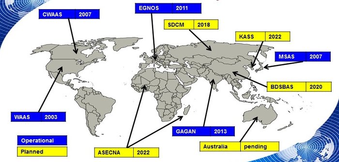
EGNOS is the European equivalent of the U.S. Wide Area Augmentation System (WAAS), which was the world’s first satellite-based augmentation system. The U.S. and European systems have been carefully designed to work together seamlessly.
Additional equivalent regional systems, fully interoperable with the existing ones are either in operation (Japan, India, Canada) or in definition or development (Russia, China, South Korea, West Africa and Australia).
Satellite-based augmentation systems worldwide. (Image: ESA)
Through the LPV-200 procedure, short for “localizer performance with vertical guidance 200 feet,” signals from space guide pilots through any weather down to within just 60 meters (200 feet) of the runway, at which point they make visual contact with the ground for a final go/no go landing decision.
EGNOS offers all-weather access to all certified runway approaches — each side of a runway requiring its own, separate, certification — without the need for expensive ground Instrument Landing System infrastructure. Satellite-based landing approaches can also be tailored to be smoother and more fuel-efficient.
Smaller airports unable to afford ground instrumentation draw the greatest benefit. Employing EGNOS means they get to operate in all weather conditions.
ESA retains the lead role in the future development of EGNOS, working with Thales Alenia Space and Airbus Defence and Space and their subcontractors to design, develop, deploy, and validate and test the new design elements.
While the current system is solely reliant on GPS, the next-generation EGNOS V3 will combine the use of GPS with Europe’s own Galileo satnav system to boost EGNOS accuracy and reliability still further. It is planned to enter service around 2025.
 The European Union Agency for the Space Programme (EUSPA) has announced that as of June 1, the latest European Geostationary Navigation Overlay Service (EGNOS) payload is operational ahead of the first V3 test signals.