Tag: European Satellite Navigation Competition

  • European satnav competition open for submissions

    The European Satellite Navigation Competition (ESNC) — the largest international competition for the commercial use of satellite navigation — is once again in search of outstanding ideas and business models for accelerating Galileo applications.

    Renowned institutions and regional partners are set to award prizes worth a total of more than 1 million in more than 20 categories.

    Submissions are due June 30.

    Innovation Network for Satellite Navigation

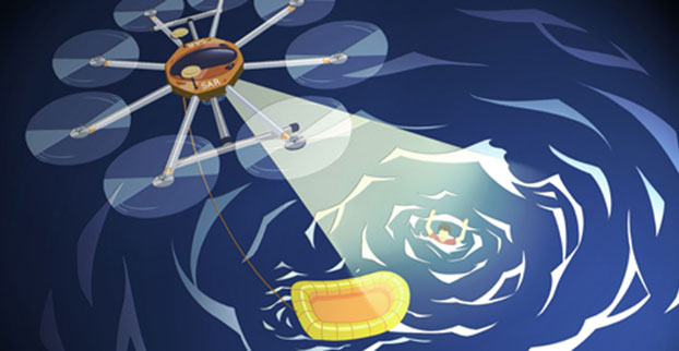
    Satellite navigation is indispensable when it comes to accurate, reliable and continuous localization, according to the ESNC. This technology is fundamental to a variety of current trends, including multimodal logistics, the Internet of Things (IoT) and machine-to-machine (M2M) communication, unmanned aerial vehicles (UAVs) and smart cities.

    First held in 2004, the ESNC has evolved into the leading innovation scouting mechanism in terms of Galileo-related applications across Europe and beyond. Moreover, the ESNC promotes the transformation of groundbreaking business ideas into market-ready products and new ventures.

    Each year, the competition offers advantages to more than 400 business ideas. It has awarded prizes to more than 300 winners, which represent just a fraction of the 3,700 innovative concepts submitted by 11,000 participants. Through its network — including the ESA Business Incubation Centres, other incubators across Europe and the new E-GNSS Accelerator co-funded by the European Commission — the ESNC plays a decisive role in the realization of promising ideas by supporting the foundation of startups and creating high-tech jobs.

    One of the main objectives of the ESNC is fostering the European space sector’s competitiveness globally by boosting the development of commercial space applications, especially for startups, SMEs and young entrepreneurs. Advancing Europe’s space programs and meeting user needs, especially when it comes to space data access to encourage alternative business models and technological progress, represent major goals of this strategy.

    ESNC-2017-kickoff

    The involvement of the pan-European spirit within the EU Space Strategy is realized in the ESNC by engaging multiple regions across Europe with their own dedicated prizes.

    “The investment in space technologies and applications as well as the support of forward-thinking entrepreneurs and startups ensure Europe’s increased competitiveness,” said Elżbieta Bieńkowska, commissioner for internal market, industry, entrepreneurship and SMEs. “To achieve this ultimate goal, the European Satellite Navigation Competition (ESNC) and the Copernicus Masters are a proven platform for trendsetting technologies and business models based on Galileo and Copernicus to implement the new EU Space Strategy.”

    Within this context, this year’s ESNC patronage taken over by Markku Markkula, president of the European Committee of the Regions (CoR), sets the tone for the innovation competition’s pan-European mission of uniting the European regions and cities through the support of space-related businesses and future-oriented entrepreneurs, increasing the market and user uptake of Galileo.

    “The European Committee of the Regions attaches great importance to the new opportunities linked to the involvement of European regions in innovation networks, such as the European Satellite Navigation Competition,” Markkula said. “I have therefore gladly taken on the role of patron for the ESNC as of 2017.”

    E-GNSS Accelerator

    As the high-tech platform for pioneering satellite navigation applications, the ESNC is now additionally equipped with the new E-GNSS Accelerator. This program is a unique opportunity for entrepreneurs and startups to accelerate their business case on a broad scale and bring their products and services to market.

    The E-GNSS Accelerator will run for three years and will directly support the winners of the ESNC 2017, 2018 and 2019. Thereby, the participants await even more prizes, services and three further business incubations worth an additional value of EUR 500,000.

    ESNC-2017-event

    ESNC Partners

    In the ESNC 2017, special prizes are to be offered in partnership with the following institutions: the European GNSS Agency (GSA), the European Space Agency (ESA), the German Aerospace Center (DLR), and the German Federal Ministry of Transport and Digital Infrastructure (BMVI).

    Prototypes can also be entered into the GNSS Living Lab Challenge.

    The University Challenge, meanwhile, is explicitly designed for students and research associates.

    In addition, participants choose from this year’s confirmed partner regions: Asia, Austria, Baden-Württemberg / Germany, Basque Country / Spain, Bavaria / Germany, Catalonia / Spain, Estonia, France, Hesse / Germany, Ireland, Madrid / Spain, The Netherlands, Norway, Poland, Romania, United Kingdom, and the Valencian Community / Spain.

    Stay tuned for more updates on additional ESNC regions.

    Obtain more information at the official website, www.esnc.eu, comprising all relevant information on prizes, partners, and terms of participation involved in the ESNC.

    Prizes for the Best Applications

    This year’s winners will take home prizes worth a more than EUR 1 million and be welcomed into the ESNC’s leading innovation network for global satellite navigation systems.

    Along with cash, the various prize categories offer primarily technical, business-related and legal support in realizing the winning business models. A jury of international experts from the realms of research and industry will also evaluate the winners of all the categories to select an overall winner, who will be revealed at the festive Awards Ceremony in early November 2017.

    Furthermore, three additional incubations, supported by the European Commission, will be awarded in front of a high-ranking audience.

    Those who enter the ESNC also stand to benefit greatly from the opportunity to work closely with leading institutions and regional partners. The ESNC is geared towards individuals and teams from companies, research facilities and universities around the world.

    Awards Ceremony and Space Conference

    A partner program, the Copernicus Masters (Earth observation), also kicked off on April 5 in Brussels.

    The Awards Ceremony for both the ESNC and the Copernicus Masters takes place in early November. The event brings together industry, politics, entrepreneurship and research to showcase the most disruptive space applications and discuss trendsetting developments in the satellite downstream sector and its various application fields.

  • ESNC 2016 opens submissions for Galileo-enabled applications

    esnc16The European Satellite Navigation Competition (ESNC) — the largest international competition for the commercial use of satellite navigation — is once again looking for outstanding ideas and business models. Renowned institutions and regional partners are set to award prizes worth a total of €1 million in more than 25 categories.

    The deadline for submissions is June 30.

    “In our modern, data-driven economy, satellite navigation is a crucial technology that facilitates constant and reliable object localisation — the bedrock of the Internet of Things,” states an ESNC press release. “Since 2004, the ESNC has evolved into a leading fixture in the New Space Economy by provided a public innovation platform for turning promising ideas into market-ready products.

    “Each year, the competition unveils new trends and more than 500 business ideas. It has already awarded prizes to more than 270 winners over the years, which represent just a fraction of the nearly 3,500 innovative concepts submitted by over 10,000 total participants.

    “Through a one-of-a-kind network that includes the ESA Business Incubation Centres and other incubators across Europe, the ESNC plays a decisive role in the realization of these ideas by supporting the foundation of startups and creating high-tech jobs.”

    The unmanned aerial vehicle (UAV) trend has also emerged in the ideas submitted to the ESNC, which selected a drone application — Poseidron — as its overall winner for the first time in 2015. Developed by the Spanish startup Sincratech Aeronautics, this multicopter is equipped with infrared cameras and uses the European positioning service EGNOS to save lives at sea.

    POSEIDrON-UAV-ESNC-valencia-O
    The Poseidron concept UAV.

    This year’s winners will take home prizes worth a total of €1 million and be welcomed into the ESNC’s leading innovation network for global satellite navigation systems. Along with cash, the various prize categories on offer primarily include technical, business-related, and legal support in realising the winning business models.

    A jury of international experts from the realms of research and industry will also evaluate the winners of all the categories to select an overall winner, who will be revealed at the annual awards ceremony.

    Those who enter the ESNC also stand to benefit greatly from the opportunity to work closely with leading institutions and regional partners. The ESNC is geared towards individuals and teams from companies, research facilities, and universities around the world. Those interested can enter the competition from 1 April to 30 June 2016 at www.esnc.eu.

    In ESNC 2016, prizes are sponsored by the following partner regions and institutions: the European Space Agency (ESA), the German Aerospace Center (DLR), the German Federal Ministry of Transport and Digital Infrastructure (BMVI), and the Horizon 2020 project BELS. Prototypes can also be entered into the GNSS Living Lab Challenge.

    The University Challenge, meanwhile, is explicitly designed for students and university research assistants. This year’s confirmed partner regions are: Asia, Austria, Baden-Württemberg, Bavaria, the Czech Republic, Flanders, France, Galicia, Hesse, Ireland, Israel, Lithuania, Madrid, the Netherlands, Norway, Poland, Romania, Sweden, Switzerland, the United Kingdom and Valencia.

    The official website offers all the relevant information on the prizes, partners, and terms of participation involved in the ESNC.

    ESNC and Copernicus Masters Info Day is scheduled for June 2 at the European Space Solutions conference in The Hague. Those interested will also have further opportunities to meet the ESNC’s organisers and their partners at numerous regional kickoff events across Europe in April and May.

  • Life-Saving UAV Wins Top Prize in ESNC 2015

    Life-Saving UAV Wins Top Prize in ESNC 2015

    Photo: POSEIDRON

    A UAV project, POSEIDRON, took top honors in the 2015 European Satellite Navigation Competition, which recognizes the year’s best innovations in commercial applications of satellite technology. POSEIDRON won over the international jury of experts with its remote-controlled multicopter built to support maritime search-and-rescue services — and took home the grand prize ahead of the European Satellite Navigation Competition’s 29 other winners.

    The award ceremony took place during the Satellite Masters Conference. The ceremony was held at the ddb forum in Berlin Oct. 20. The awards ceremony was held in conjunction with the Copernicus Masters awards for Earth observation.

    Thorsten Rudolph, Ulrike Daniels (both Anwendungszentrum GmbH), David Argiles (ValSpace Consortium), Rudesindo Hernando Meliá, Maria Dolores Albiol Simo, Manuel Pedreira Gimenez, Jorge Esteve Ripollés and Enrique Martínez Asensi (all Sincratech Aeronautics) and Dorothee Bär (German Federal Ministry of Transport and Digital Infrastructure (BMVI)) © Anna Kreuz
    Thorsten Rudolph, Ulrike Daniels (both Anwendungszentrum GmbH), David Argiles (ValSpace Consortium), Rudesindo Hernando Meliá, Maria Dolores Albiol Simo, Manuel Pedreira Gimenez, Jorge Esteve Ripollés and Enrique Martínez Asensi (all Sincratech Aeronautics) and Dorothee Bär (German Federal Ministry of Transport and Digital Infrastructure (BMVI)). (Photo: Anna Kreuz)

    Enrique Martínez Asensi and his winning team hope to see Poseidron save lives far out at sea when people fall overboard or are involved in shipwrecks that occur during illegal immigration. Custom-developed by Sincratech Aeronautics — a start-up based in Valencia, Spain — POSEIDRON can be launched from ships or platforms under virtually any weather conditions. The multicopter uses thermal cameras and the European positioning service EGNOS to quickly locate people in the water and transmit an alarm to rescue teams along with precise information. Capable of carrying up to 70 kilogrammes, it can also transport a dinghy and deploy it as soon as casualties are found. This is what makes POSEIDRON both faster and more cost-effective than other rescue systems, which in turn significantly increases the chances of survival — particularly in cold waters.

    In addition to winning the ESNC’s EUR 20,000 grand prize, the innovative project will now have the chance to enter a 12-month incubation programme at one of five Science Parks in Valencia as part of the region’s prize.

    The ESNC set a new participation record this year, with 515 innovations entered by companies from more than 40 different countries around the world. The competition more than matched the successes of past editions in increasing its overall figures to 272 winners awarded and 3,343 ideas received from more than 10,000 participants throughout its 12 years in existence.

    “Time synchronization and reliable positioning information are essential to today’s digital economy: Without corresponding satellite-based services, the development of these and other innovations — including the Internet of Things, machine-to-machine communication, and Industry 4.0 — would not be possible,” explained Thorsten Rudolph, CEO of ESNC initiator and organiser Anwendungszentrum GmbH Oberpfaffenhofen. “As the ideas submitted to this year’s ESNC have shown to impressive effect, it is these forward-thinking technologies in particular that present a great deal of potential waiting to be unleashed by high-tech start-ups.”

    Under the patronage of the German Federal Ministry of Transport and Digital Infrastructure (BMVI), the ESNC presented prizes valued at approximately EUR 1 million in total at its festive Awards Ceremony.

    The competition’s jury of 240 renowned experts selected both the overall victor and 30 other regional and special prize winners. With their innovations in areas such as connected mobility, smart cities, tourism and environmental protection, these entrants demonstrated how fundamental precise satellite navigation signals are to Europe’s digital society.

    2015 Winners

    Overall Winner

    Loles Albiol Simó, Rudesindo Hernando Meliá, Jorge Esteve Ripollés, Manuel Pedreira Giménez, Enrique Martinez Asensi :: OVERALL WINNER – Valencian Community / Spain
    POSEIDRON: Remotely Piloted Aircraft System for Search and Rescue and Environmental Defence

    Special Prize Winners

    Rafael Olmedo, Juan Domingo, Laura Concepción :: GSA
    KYNEO: The Open Navigation Platform for the GNSS of Things (Read more abut this prize here.)

    Su Zhenzhong, Tonio Gsell, Alexander Wolf :: ESA
    RTKNAV – A Low-Cost, Compact, User-Friendly, Centimetre-Accurate, Real-Time Navigation Solution

    Dariusz Tanajewski, Grzegorz Grunwald :: DLR
    Mobile Underwater Positioning System (MUPS)

    Jukka Talvi, Joni Jämsä, Kalle Arola, Jukka-Pekka Alanissi, Antti Koponen :: BMVI/BMWi
    HALI – Always Green Traffic Signals for Emergency Vehicles

    Prof Dr Nick van de Giesen, Dr Eugenio Realini :: University Challenge
    GNSS Monitoring of Precipitable Water Vapour over East Africa Using Low-Cost Receivers

    Jasper Ettema, Sabine Ettema :: GNSS Living Lab
    Position-Based Assistance in Case of Sudden Cardiac Arrest

    Regional winners

    Suresh Babu Mandalanka :: Asia
    GeoKey – A Locking System That Uses Geographic Locations as Keys

    Jasper Ettema, Sabine Ettema :: Austria
    Position-Based Assistance in Case of Sudden Cardiac Arrest

    Dr Walter Naumann :: Baden-Württemberg / Germany
    ICARUS – A New Global Tracking Service for Small Objects

    Jorge Querol, Adriano Camps :: Barcelona / Spain
    FENIX – Front-End GNSS Interference eXcisor

    Ronen Korman, Shay Rootman, Ehud Spiegel :: Bavaria / Germany
    Hi-Park – Real-time, Crowdsourced, On-Street Parking Information Using Drivers’ Smartphone Cameras

    Ladislav Bartuška :: Czech Republic
    Biological Protection of Airports Using Drones

    Ronny Webers, Bart Lenaerts, Vincent Jorissen :: Flanders / Belgium
    JobWalkr – The First Mobile App That Informs You About Job Opportunities in Your Neighbourhood

    Daniel Neveux D’Agata, Laurent Kerbrat, Maïwenn Penhouët :: France
    WIZAR – A new way to discover history and heritage

    Alberto Gonzalez, Antonio Vazquez, Bibiano Fdz-Arruti, Aaron Nercellas, Diego Hurtado, Diego Nodar, Fernando Aguado, Franco Pérez :: Galicia / Spain
    Point&Pin – Remote Localisation for Emergency Situations

    Oscar Serradilla :: Gipuzkoa / Spain
    Pothole Avoider

    Achilles Chatzinikos, Evangelos Kassimatis, Takis Dimitrakopoulos :: Greece
    TripInView | Dream. Plan. Experience.

    Sibylle Geiger, Jens Liebau, Nezar Mahmoud :: Hesse / Germany
    Discover a Great Variety of Local Foods with the frimeo App

    Aidan Flanagan, Colm Murphy :: Ireland
    112GPS.com – More accurate emergency calls

    Ronen Bitan, Tal Lavi :: Israel
    Trailze – Complete Outdoors Experience

    Dr Saulius Rudys, Mantautas Rudys :: Lithuania
    Fully Camouflaged GNSS-GSM Anti-Theft System for Bicycles

    Carlos Callejero Andrés, Julio Pantoja Dominguez, Ignacio Gómez Maqueda :: Madrid / Spain
    VardiaN – Big Data Platform of Connected PPEs to Prevent Accidents in Hazardous Environments

    Prof Dr Nick van de Giesen, Dr Eugenio Realini :: The Netherlands
    GNSS Monitoring of Precipitable Water Vapour over East Africa Using Low-Cost Receivers

    Thomas Jelle, Ingjard Sandhei, Åsmund Tokheim, Dag Jomar Mersland, Morten Tvenning, Iván Sánches Ortega, Robert Badnall :: Norway
    MazeMap – High-quality, interactive, searchable, and linkable indoor maps

    Jan Filipowiak, Radoslaw Jastrzebski, Maciej Glowacki :: Poland
    Pastguide: Virtual Reality in Real Places

    Florin Banica, Andreea Diana Banica :: Romania
    Shared Ahead – A Truck-Sharing System

    Su Zhenzhong, Tonio Gsell, Alexander Wolf :: Switzerland
    RTKNAV – A Low-Cost, Compact, User-Friendly, Centimetre-Accurate, Real-Time Navigation Solution

    Zoe Farrington, Andrew Richardson :: United Kingdom
    REALRIDER®

    Loles Albiol Simó, Rudesindo Hernando Meliá, Jorge Esteve Ripollés, Manuel Pedreira Giménez, Enrique Martinez Asensi :: Valencian Community / Spain
    POSEIDRON: Remotely Piloted Aircraft System for Search and Rescue and Environmental Defence

    Nicolas de Kerchove, Joel Mendez, Oscar Marí :: Wallonia / Belgium
    A New Concept for a Location-based Mobile Game with an Innovative Monetisation Platform


  • 2015 GSA Prize Highlights GNSS Role in Internet of Things

    The 2015 edition of the European Satellite Navigation Competition GSA Special Prize was awarded to Rafael Olmedo for the KYNEO project. The project develops inexpensive, flexible Galileo and EGNOS enabled modules that allow ubiquitous positioning data for applications in the Internet of Things. Other winners of the competition are listed here.

    Described as an open innovation platform for the GNSS of Things, the basis of the KYNEO concept is a perceived need to be able to fast prototype applications and devices in the rapidly developing field of the Internet of Things. According to Olmedo, a variety of Internet of Things platforms are looking for positioning systems that can be flexible and adapted to a variety of situations and circumstances. To serve this objective, the product works as an open-source software for the creation of interactive electronic objects.


    REMINDER: For continued undisturbed use of GPS as Internet use mushrooms, led by the booming Internet of Things, more efficient utilization of spectrum bandwidth on all sides is essential; for this, synchronization is key. Timing experts will share their views during GPS World‘s “Timing, Time Transfer and Synchronization: New Applications and Techniques” webinar sponsored by EndRun Technologies on Thursday, Oct. 29.  Registration is free.


    “There is a huge development community for digital electronic products out there, and our aim with KYNEO is to provide a great positioning tool for this community,” Olmedo said. “The first KYNEO products are already available to order via our website, but we will also sell via the many open hardware platforms that already serve the developer community.”

    “The Internet of Things is a potentially massive global market for European GNSS programs, offering many benefits to the end users,” said GSA Executive Director Carlo des Dorides. “Open source programmes like the KYNEO project will not only prove to be competitive in their own right, but will also open doors to related services and other opportunities.”

    The project was selected from a record-breaking 192 entries. Entries came from 29 different countries, with 72 entries coming from individuals and 59 from start-up companies. The award was announced during a special awards ceremony, held on the opening day of the Satellite Masters Conference in Berlin.

    About the European Satellite Navigation Competition

    Since 2004, the European Satellite Navigation Competition (ESNC) has been rewarding the best services, products, and business cases that utilize satellite navigation in everyday life. Over this time, ESNC has evolved into an international innovation competition — one that recognizes the best ideas in the field of satellite navigation. Entries come from a wide range of companies, research institutes, students and individuals.

    “The GSA Special Prize nicely complements the Agency’s focus — getting closer to the end user and helping them benefit from European space technology,” des Dorides said. “Whether through competitions like this, or through such funding programmes and Horizon 2020 and Fundamental Elements, it’s by supporting innovative applications like KYNEO that the GSA will be able to succeed at its mission.”

    Each year, the GSA Special Topic Prize awards the most promising European GNSS application idea. The winner of the GSA prize has the opportunity to realise his or her idea at a suitable EU incubation centre for six months, with the option of an additional six months based on evaluation after the first period. The award criteria is based on the uniqueness and originality of the idea, its business (and social) potential, the credibility of the corresponding team, and the application’s use of unique EGNOS/Galileo features.

  • Next-Generation Tracker Debuts

    Photo: StickNTrackStickNTrack — an award-winning low-power tracker from Sensolus — is now active in eight European countries.

    StickNTrack guards and tracks position, journeys, motion and status of any non-powered asset without the hassle of charging batteries, managing SIM cards or an intrusive installation, Sensolus said.

    StickNTrack’s web-based service platform is tailored for low-power asset tracking communicating over the French-based Sigfox. Because Sigfox is an ultra low-power communication network, it significantly reduces StickNTrack’s power needs so that it consumes up to 40 times less power and lowers life-cycle costs by 50 percent compared to existing compact GPRS/GPS products, Sensolus said.

    The tracker’s power can last up to five years. In the third quarter, an upgraded version will be released with extended battery lifetime up to nine years, according to Kristoff Van Rattinghe, who developed StickNTrack along with Laurence Claeys, Johan Criel and Koen Van Vlaenderen.

    Users can access the StickNTrack web portal with any smartphone running Android OS or iOS. The full feature set can be accessed on a tablet or laptop. Features include interactive timelines, intuitive geofencing, email alerting and optimized energy savings.

    The ruggedized, waterproof StickNTrack is 120 x 50 x 25 millimeters and weighs 255 grams. It can track assets on the water, such as yachts or buoys, providing automated logbooks, alerting users when assets enter or exit specific zones (such as harbors), and providing real-time journey information for those at home.

    StickNTrack’s developers took third place in the 2014 European Satellite Navigation Competition, after taking first in the Flanders regional competition. It also won the European Space Agency’s Innovation Award.

    Dubbed a “distruptive innovation” by the European Satellite Navigation Competition (ESNC), StickNTrack “opens up an abundance of new business opportunities in tracking trailers, containers, machinery, tools, bikes and more. Future accuracy and availability improvements based on GNSS will trigger additional advancements, such as by automating supply chains for packages and their delivery. Ultimately, stickNtrack is a next-generation location tracker that significantly lowers the barriers to embedding even more GNSS technology into our daily lives.”

    “Every day new types of non-powered assets are being connected to our service platform,” Van Rattinghe said. In the coming years, Sigfox aims to provide global coverage.

  • ESNC 2015 Now Accepting Submissions

    International Kickoff for the 2015 ESNC is scheduled for April 21 in London.
    Winners in the 30 categories will be announced in October.

    The 2015 European Satellite Navigation Competition (ESNC), an international innovation competition that recognizes the best ideas in satellite navigation, will run from April 1 to June 30. Winners will be announced in October.

    There are more than 20 regions participating, and the ESNC will award prizes worth a total of €1 million in 30 categories.

    “Satellite navigation is an essential element of modern mobility and a key technology in particular, in the age of a data-driven economy. This is exactly where the European Satellite Navigation Competition comes in. It provides a public platform to the creative community in order to help promising ideas turn into solutions that are commercially mature and generate added value for society,” said Alexander Dobrindt, Germany’s Federal Minister of Transport and Digital Infrastructure (BMVI).

    A jury of international research and industry experts will select the year’s overall champion among the winners of the categories, which comes with an additional €20,000 and access to a six-month incubation program in the champion’s preferred region.

    ESNC_London_kickoff_2015
    International kick-off for the 2015 ESNC is scheduled for April 21 in London.

    “As the Galileo satellite constellation continues to expand, efforts to promote corresponding applications will become increasingly important. This is where the ESNC is already playing a key role,” said Matthias Petschke, the European Commission’s director of satellite navigation programs. “As such, the Commission is definitely looking forward to seeing the creative and innovative GNSS-based applications submitted this year.”

    This year’s special topic prizes are being sponsored by the European GNSS Agency (GSA), the European Space Agency (ESA), the German Aerospace Center (DLR) and the Ministry of Transport and Digital Infrastructure (BMVI) in cooperation with the German Federal Ministry for Economic Affairs and Energy (BMWi). Entrants may submit prototypes to the GNSS Living Lab Challenge, while the University Challenge specifically addresses students and research assistants.

    “Those who enter the ESNC benefit in particular from our global network, which provides them with tailored support in developing their business concepts and bringing them to market,” said Thorsten Rudolph, managing director of Anwendungszentrum GmbH Oberpfaffenhofen.

    All of the information on this year’s prizes, partners, and terms of participation is available at the ESNC website.

  • ESNC University Challenge Recognizes Hail Suppression Project

    ENSC-university-award-hail
    © Peter Zentgraf

    A hail suppression project dubbed RO-BERTA by the University of Applied Sciences, Rosenheim (Germany), has been selected the winner of the European Satellite Navigation Competition’s (ESNC) University Challenge. Judged by an international expert jury, the University Challenge is a special prize to reward innovative ideas emerging from Europe’s universities.

    The Hail Navigator system is designed to reduce damage caused by hail. Based on the premise of suppressing the formation of hail by injecting silver iodide into clouds, Hail Navigator combines navigation with a precipitation reporting system that can guide pilots to optimal locations for hail suppression missions.

    The system is complemented by weather observations (including precise times and locations) reported by local citizens via a smartphone app, which aids the validation of weather prediction models. These models constitute an important factor in deciding whether a hail suppression flight is necessary.

    The project team was awarded the prize on October 23 in Berlin at the ESNC Awards Ceremony. More than 300 guests attended, representing the top European players in the navigation sector. In addition to cash, the prize includes support through the GNSS Research & Applications Centre of Excellence (GRACE) and a free ticket to the Munich Satellite Navigation Summit 2015.

    “Winning this prize once again demonstrates that interdisciplinary cooperation is feasible and successful,” said Project Manager Peter Zentgraf. “The positive feedback the competition provides helps drive our many students to continue their dedicated work, which made it possible to reach our project goals.”

    Airbus Space & Defense won the regular ENSC competition.

  • Airbus Defence & Space Wins ESNC Competition

    The Airbus team (from left): Thorsten Rudolph, Jan Wendel, Wolfgang Kogler, Rolf Densing. Photo: ESNC
    Thorsten Rudolph, Application Center GmbH Oberpfaffenhofen (left), and Rolf Densing, DLR (right), award the Airbus team of Jan Wendel and Wolfgang Kogler the EUR 20,000 grand prize. Photo: ESNC

    The winner of the European Satellite Navigation Competition (ESNC) 2014 is Airbus Defence & Space, which won over the jury of experts from around the world with its ground-breaking and cost-effective receiver for the Galileo Public Regulated Service (PRS).

    The award winners were announced October 23 at an awards ceremony held at the Berlin headquarters of Deutsche Telekom. The awards recognize innovations in the commercial use of satellite navigation technology.

    “Award winners Wolfgang Kogler and Jan Wendel from Airbus Defence & Space have taken a cutting-edge approach to designing a low-cost receiver that enables police departments, fire brigades, emergency medical services, and other public entities to make use of the Galileo PRS system,” The ESNC said. “Its core innovation involves the development of a special network architecture that combines the receiver with an assistance server. The concept accounts for all the required security aspects and significantly reduces costs and the complexity of user receivers, thus facilitating broader use of PRS in the realm of public security.”

    Airbus-bavaria-prs

    In addition to the EUR 20,000 grand prize, the design took home Bavaria’s regional prize and the ESNC’s special PRS prize, which was awarded by Germany’s Federal Ministry of Transport and Digital Infrastructure (BMVI) and Federal Ministry for Economic Affairs and Energy (BMWi).

    “This special prize reflects our effort to further examine possibilities for the use of PRS applications,” said Tobias Miethaner, Head of the BMVI’s Digital Society, in his opening address at the awards ceremony. “I am delighted to see that the ESNC is already providing an important impetus to the promotion and development of innovative applications of the future Galileo PRS in its first year.”

    Over the past decade, the ESNC has brought forth numerous new applications in the field of satellite navigation. The 2014 edition was shaped in particular by the imminent launch of the first Galileo services, with more than 40% of the 434 submissions received from more than 40 countries seeking to employ Galileo/EGNOS in their own products and services.

    “Thanks to our international network, we’re in an excellent position to take advantage of Galileo’s operational launch,” said Thorsten Rudolph, managing director of Anwendungszentrum GmbH Oberpfaffenhofen, which initiated and continues to organize the ESNC. “We believe that the ESNC’s function as a leading innovation framework in its field will grant it an equally important role in Europe’s new satellite navigation system.”

    Along with the overall winner, 240 experts in the ESNC’s renowned network selected more than 30 other winners in the competition’s regional and special-prize challenges. Under the patronage of Germany’s Federal Minister of Transport, prizes worth a total of EUR 1 million were presented at the awards ceremony. The winners illustrated the fundamental importance of robust, reliable, and secure time and positioning signals for Europe’s digital society through innovations in areas such as transport, health, and the environment.

    2014 Special Prize Winners

    In addition to selecting its overall winner, the 11th European Satellite Navigation Competition (ESNC) has awarded prizes in six different special categories and to 25 regional winners.

    GSA: The most promising application idea for European GNSS

    Giovanni Arturo Vecchione and team, Deimos Space, Spain: Galileo for ARA / A New Galileo Module for the ARA Platform

    The Galileo for ARA module will use a key feature of Galileo – its E5 broadband signal – to create new possibilities in the development of smartphone applications that require high accuracy. The team thus plans to integrate E5 Galileo receiver modules for enhanced accuracy and develop an antenna interface module to provide better performance. This will offer improved positioning precision with centimetre-level accuracy and a multipath-resistant solution designed for pedestrians and urban environments. 

    ESA Innovation Prize & Flanders/Belgium — Overall Ranking: 3rd Place

    Kristoff Van Rattinghe and team, sensolus, Belgium: The Next-Generation Location Tracker – Just stickNtrack

    stickNtrack is a disruptive innovation that opens up an abundance of new business opportunities in tracking trailers, containers, machinery, tools, bikes, and more. It functions for up to 10 years without the hassle of charging batteries, managing SIM cards, or any intrusive installations while consuming up to 40 times less power. StickNtrack also lowers life-cycle costs by 50% compared to current compact GPRS/GPS products.

    DLR: GNSS Reloaded – Applications in Context

    Michal Rutkowski, Poland: SBAS Retranslation / Pseudolite System for Precision Approach and Air Navigation

    This artificial ground-based solution will significantly boost the coverage of satellite-based augmentation systems (SBAS, such as EGNOS) to ensure safe landings on all airport runways. SBAS assistance can be limited due to a lack of signal coverage in the far north, in the mountains, or in highly urbanised areas. By receiving and retransmitting GPS corrections, the proposed system will enable the use of systems like EGNOS in such difficult environments. Thanks to its competitive cost and reliability, this system will be a strong alternative to conventional instrument landing systems (ILS).

    University Challenge

    Peter Zentgraf and team, University of Applied Sciences Rosenheim, Germany :: Hail Navigator and Precipitation Reporting System for Hail Suppression Aircraft

    Hail Navigator is a novel system designed to reduce damage caused by hail. The formation of hail can be suppressed by injecting silver iodide into clouds. Hail Navigator combines navigation with a precipitation reporting system that can guide pilots to the optimal locations for their hail suppression missions. The system is complemented by weather observations (including precise times and locations) reported by the local population via a smartphone app as a means of validating weather prediction models. These models constitute an important factor in deciding whether a hail suppression flight is necessary.

    GNSS Living LabPrize

    Adrian Blackwood and team, trakkies Research BV, the Netherlands: EGNOS and the REAL Internet of Things

    trakkies has built the world’s first REAL platform for the Internet of Things (IOT). It enables users to keep better track of belongings, events, tasks, appointments, and more. The start-up has developed IOT nodes with ambient intelligence, a smartphone app, and a back-end cloud system for providing helpful, intuitive services and interacting with people, places, and things. Furthermore, trakkies has designed a novel small-data mechanism that identifies individual people, places, and objects and uses EGNOS signals to create smart location references.

    To see the regional prize winners, visit the ESNC website.

  • Summer — and the Living Ain’t Easy

    Summer 2014 will be one that the €6.3 billion (US$8.2 billion) Galileo GNSS programme will need to chalk down to experience and hope to move on from. At the time of my last EAGER column, we were starting to get a hint that one of the four in-orbit Galileo IOV satellites was not functioning. We now know that it has suffered a catastrophic power failure.

    And in August, celebrations for a successful launch of the first two Galileo FOC satellites, named Doresa and Milena, quickly went sour when it became clear that they had suffered an anomaly during launch. And a very big anomaly at that.

    We are still awaiting the preliminary results from the inquiry set up by the European Space Agency (ESA), the European Commission, and the rocket’s operator Arianespace. It is hoped that the results of the inquiry board will be available at the end of September.

    ESA spokesperson Franco Bonacina informs me that on the satellite side, ESA’s teams at the ESOC control centre are investigating the possibility of partially raising or modifying the orbit of the two satellites, which are fully under control and in good health. They are also considering performing some software adaptations on board the spacecraft and at ground station level to try and make them “be seen” as operational satellites and able to provide operational services within the Galileo system. All this is still “work in progress” and it will take a few more weeks to be fully evaluated and put into practice.

    So, what went wrong?

    In the absence of firm conclusions from the inquiry, the rumour mill has been running at full throttle with the wide range of theories from cock-up to conspiracy.

    What we do know is that the Galileo craft were supposed to be launched by a Soyuz-Fregat rocket into a circular orbit 23,222 kilometres above the Earth and angled at 56 degrees to the planet’s equator. The initial launch from Kourou, French Guiana, on August 22 seemed to be smooth and nominal, but something went wrong in the final stages of the flight, and the two satellites were placed in an elliptical orbit varying from more than 2,000 kilometres too high to nearly 10,000 kilometres too low and also tilted by about 5 degrees from the intended plane.

    The most plausible explanation for the anomaly is that the Soyuz – Fregat upper stage suffered a control malfunction at some point before its final orbital injection burn. So although the rocket engine seems to have fired correctly, the craft wasn’t pointing in the right direction.

    In fact, I am told that a likely mechanical root cause for the anomaly in the Fregat stage has been identified by the inquiry committee; however, more information is being gathered and further technical analysis is required to verify this.

    Can anything be done?

    Doresa and Milena do not have enough fuel on board to achieve the correct orbit for full Galileo operations.

    Some interesting solutions have been proposed to launch a rescue mission to drag the errant satellites into their correct orbit, but that could be a slow, risky and expensive exercise. So could the satellites be useful in situ?

    For most GNSS uses, the answer is probably no. Despite the fact that the satellites themselves are apparently working perfectly, in a safe state, correctly pointing towards the Sun, properly powered and fully under control of the ESA team, their elliptical orbit does not conform with Galileo’s standardized data format. For example, the value that represents the shape of the satellites’ orbit is too big to be expressed within the allotted bit limit for that parameter.

    Marco Falcone, ESA’s Galileo system manager, says his team have been working intensely to determine if the satellites can be at least partially recovered. Among the considerations are the flight dynamics of moving the two spacecraft and the impact of the radiation they are experiencing in their current location, which can shorten the satellite’s lifetime. “It’s very dangerous for the satellite,” admits Falcone.

    Another unknown is the timing performance of the satellites’ rubidium frequency and hydrogen maser given the relativistic effects of their orbit. Signal issues, such as the navigation message almanac, also must be considered before the FOC satellites can be introduced into operation, Falcone said.

    Good for geoscience?

    But according to fellow GPS World contributor Richard Langley of the University of New Brunswick, the situation is more hopeful for scientists wanting to use Galileo-derived data in their research. Quoted in an article in leading science journal Nature, Richard says that researchers tracking GNSS satellites via the IGS global network of ground stations combine that information with the timing data transmitted by the satellites themselves and could use it to measure changes in the position of points on the ground much smaller than the one-metre margin of error for standard navigation-system receivers. This level of precision is good enough to detect millimetres of movement in tectonic plates, for example.

    This reminded me of a presentation by a team of Italian scientists I saw recently. The VADASE (Variometric Approach for Displacements Analysis Stand-alone Engine) project uses a novel strategy consisting of an algorithm able to perform real-time retrieval and estimation of displacement and waveforms based on high-frequency (1 Hz or more) carrier phase observations collected by a stand-alone GNSS receiver. The algorithm works with broadcast data (satellite clocks and orbits), requires very simple hardware, and has demonstrated potential application in real-world situations such as earthquake risk assessment (and related early-warning systems for tsunamis) and structural monitoring (see citations below). VADASE had already achieved a Galileo-only displacement solution using the four IOV satellites in orbit.

    I contacted Gabriele Colosimo at Rome’s “Sapienza” University, and he confirmed that, although the satellites could not be used for direct gravimetric studies that require a very low orbit (below 1,000 km), the data from Doresa and Milena could be used to estimate displacements of GNSS receivers. He and the VADASE team think that a slight adjustment in their algorithm might be needed depending on the exact orbit parameters of the satellites, but the data would be useable without any significant change in orbit being required.

    Gabriele also thinks that the data could be used to usefully contribute to studies in fields such as troposphere studies and GNSS reflectometry, as well as for geodynamic and seismic monitoring using GNSS.

    Munich Masters

    Hopefully the mystery of Doresa and Milena’s anomaly will have been resolved by October 23, when the 2014 European Satellite Navigation Competition (ESNC) awards ceremony takes place in Berlin in conjunction with the two-day Satellite Masters Conference.

    Gabriele and the VADASE team are in the running for a prize — so we wish them well.

    But the real prize for the European GNSS community would be a full explanation of the recent Galileo issues, and how they are being resolved, and a clear statement and timeline on the future deployment and implementation of this flagship programme.

    A bientôt – as they say in these parts


    Citations

    G.Colosimo, M. Crespi and A.Mazzoni, “Real-time GPS Seismology with a stand-alone receiver: A preliminary feasibility demonstration,” Journal of Geophysical Research, vol 116, doi: 10.1029/2010JB007941

    M. Branzanti, G.Colosimo, M.Crespi and A.Mazzoni, “GPS near-real-time coseismic displacements for the great Tohoku-oki earthquake,” IEEE Geoscience and Remote Sensing Letters, vol 99, doi: 10.1109/LGRS.2012.2207704