The Australian government is investing in GPS technology that will create jobs and support Australian industry.
Minister for Resources and Northern Australia, Senator Matt Canavan, said the government is investing more than $260 million to develop the satellite technology.
“We rely on satellite and GPS technology for just about every aspect of our lives — from Google Maps on our individual phones, through to air traffic control at the busiest airports,” Canavan said. “More precise technology will make Australian businesses more productive, safer and more efficient.
Specifically, Canavan said, “More accurate GPS will improve productivity by allowing new technology to be created and used across the economy. Growing Australia’s digital economy will also benefit developed sectors such as mining, transport, construction, aviation and agriculture. “This investment will improve competitiveness and secure jobs across the Australian economy.”
SBAS Testbed. Under the package, $160.9 million will deliver a Satellite-Based Augmentation System (SBAS) to improve the reliability and the accuracy of positioning data from five meters to 10 centimeters across Australia and its maritime zone.
The $160.9 million includes funding over four years from 2018-19 and $39.2 million in ongoing funding from 2022-23. It will realize the SBAS testbed, which is currently running across Australia-New Zealand.
CRCSI is an international research and development centre set up in 2003 under the Australian Government Business Cooperative Research Centres Programme. The CRCSI is managing the industry-based demonstrator projects of the SBAS testbed and the economic benefits study. The infrastructure management is being led by Geoscience Australia in partnership with Land Information New Zealand and the global technology companies GMV, Inmarsat and Lockheed Martin.
“We have been coordinating multiple trials of first and second generation SBAS and Precise Point Positioning correction signals since mid-2017,” said Graeme Kernich, CRCSI CEO. “Our industry partners are crying out for this technology because a more precise positioning capability brings far-reaching and lasting impacts.
“Data analysis results and the economic benefits reported from the testbed are very promising and will translate across agriculture, aviation, consumer, construction, maritime, mining, rail, road, spatial and utilities.
“This is a formidable technology story and a practical demonstration of downstream space applications. We are looking forward to continuing the testbed over the coming nine months and assessing the economic and social benefits the operational system will bring to Australia, and possibly New Zealand,” Kernich said.
“The CRCSI has a strong track record of bringing the best people together from the private sector, government and academia to solve the most complex spatial problems; the SBAS testbed is one of the finest examples of this,” Kernich said.
“More accurate and reliable satellite positioning technology will improve the safety and efficiency of many sectors across Australia and New Zealand,” he said. “There are 28 projects across 10 sectors, with over 150 collaborating organizations currently involved in the testbed, making the footprint of this world-first trial truly trans-Tasman.”
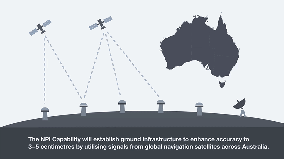
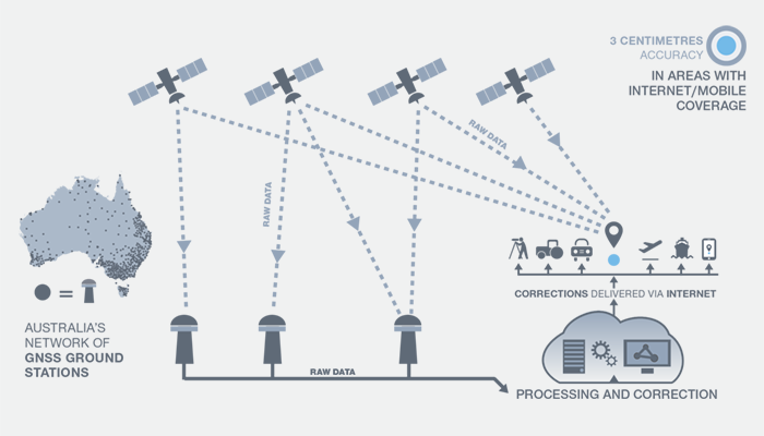
National Positioning Infrastructure. A $64 million investment in the National Positioning Infrastructure Capability (NPIC) will complement SBAS to improve GPS to an accuracy as precise as 3 centimeters in areas of Australia with access to mobile coverage.
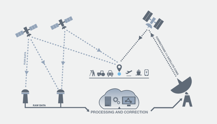
The national positioning infrastructure project will establish additional ground stations and augment GNSS signals to deliver high accuracy positioning. This will ensure nationally consistent and accurate positioning of 3 centimeters can be provided across Australia in areas with mobile coverage. The project will achieve this by:
- building new GNSS ground stations and integrating existing stations to enable multiple GNSS signals to be received for precise positioning across Australia.
- establishing a GNSS data analytics capability to verify and correct the positioning signals for the user. This will ensure Australian industry has access to world-leading software tools for positioning.
- engaging existing and new industries and service providers to raise awareness of the opportunities positioning opens up for businesses through increased productivity, safety and innovation.
“Our investment in this world-standard technology will have direct benefits including virtual fencing for farms and better management of cattle and livestock over vast distances,” Canavan said.
“It also has applications for regional aviation such as improved access to regional areas by enabling planes to land on smaller airstrips and navigate difficult terrain such as canyons.
“The increased reliability provided by better GPS will improve safety for aircraft flying into regional and remote aerodromes, such as the Royal Flying Doctor Service fleet. It will reduce the impact of weather on flight cancellations and diversions, and improve the safety of landings.
“The resource sector will also benefit through better control of mine infrastructure, safety and more precise data for environmental rehabilitation.
“This is a practical investment to improve the lives of Australians and make businesses more productive. This technology provides instant, reliable and accurate positioning information, anytime and anywhere around Australia.”
Digital Earth Australia. A further $36.9 million is for Digital Earth Australia, a technology that will give Australian businesses greater access to reliable, standardized satellite data that identifies physical changes to the Australian environment.
“The practical benefits of this investment will extend across our economy. This data will help researchers, governments and business better understand environmental changes, such as coastal erosion, crop growth and water quality,” Canavan said. “For example, information drawn from satellites is vital to help graziers increase the capacity of paddocks and make their farms more viable and sustainable.
“Our investment in satellite imagery will ensure a range of Australian industries have access to data that can help them tailor their investments, create jobs in target regions and increase their competitiveness.”

