Tag: fitness

  • U-blox signs deal with UK start-up for cutting-edge GNSS technology

    U-blox signs deal with UK start-up for cutting-edge GNSS technology

    Map plot from live tests in London show the route of a vehicle driven through Canary Wharf. It shows the difference between the position provided by a standard smartphone GNSS chip (red line) and the same data run through Focal Point Positioning's Supercorrelation software (blue line). (image: u-blox)
    Map plot from live tests in London show the route of a vehicle driven through Canary Wharf. It shows the difference between the position provided by a standard smartphone GNSS chip (red line) and the same data run through Focal Point Positioning’s Supercorrelation software (blue line). (Image: u-blox)

    U-blox has signed a deal with the award-winning U.K.-based technology company Focal Point Positioning to integrate technology that will improve the accuracy and reliability of GNSS devices. Focal Point’s Supercorrelation technology enhances positioning performance and security for applications such as smart cities, location-secure internet of things (IoT) and health and fitness wearables.

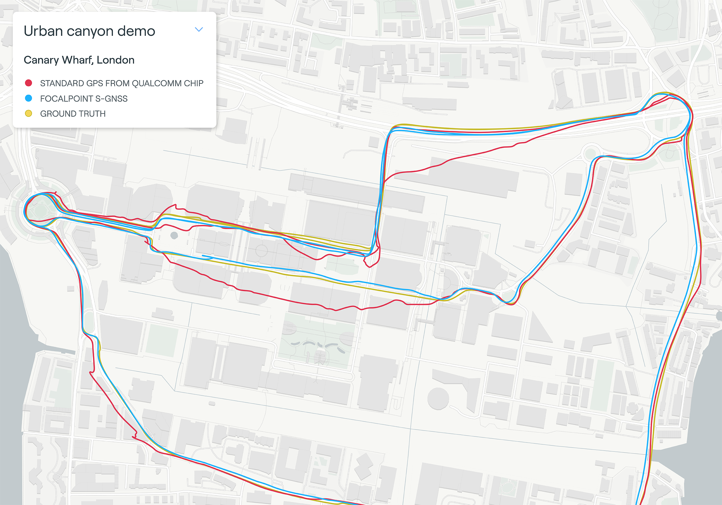
    The patented Supercorrelation technology solves a critical weakness in GNSS caused by multipath interference. Multipath interference occurs when satellite signals bounce off buildings and landmarks, causing GNSS receivers to provide degraded positioning outputs.

    The result for users is that the blue dot on their phone or device may be in the wrong place, moving in the wrong direction, or may have a large error ellipse. For autonomous vehicles it could lead to positioning errors that place the vehicle in the wrong lane or worse.

    FocalPoint’s Supercorrelation technology uses software to detect and reject reflected signals, resulting in an improvement in the performance of GNSS devices without the need for additional hardware or applications. Supercorrelation also helps with the detection and rejection of GNSS spoofing signals — an increasing concern for autonomous vehicles, ships, and aviation.

    “We are tremendously excited to be working alongside a market leader such as u-blox, our mission is to improve every positioning system on the planet and we have taken a giant step forward in that vision with this deal,” said Focal Point Positioning CEO Ramsey Faragher. “Positioning systems are so critical to our world, and we look forward to seeing the next generation of products and services that will be enabled by this higher level of accuracy, reliability and security.”

    u-blox CEO Thomas Seiler commented, “The addition of Supercorrelation technology into our latest GNSS platforms is part of our continuing focus on low power consumption, higher accuracy and security for automotive, industrial, and wearable GNSS applications.”

  • GPS World Europe editor chairs session at Munich Summit

    GPS World Europe Editor Tim Reynolds chairs the session GNSS and Sciences for Life at the Munich Navigation Satellite Summit, which will be held March 1-3. Early registration ends on Sunday, Jan. 17.

    Tim Reynolds
    Tim Reynolds

    Reynolds is director of Inta Communication Ltd. and a long-term Brussels observer writing on many aspects of European government policy and implementation for a range of clients and publications. He is the contributing editor for GPS World’s new quarterly e-newsletter, EAGER: the European GNSS and Earth Observation Report.

    The annual summit, held in the historic Munich Residenz, is an conference with global impact dealing with satellite navigation. The one-of-a-kind convention of high-ranking worldwide speakers from industry, science and governments provides the participants with a broad overview and different perspectives on the latest developments in the field of GNSS.

    Reynold’s session, GNSS and Sciences for Life, will cover maritime search and rescue (SAR), precision agriculture and livestock management, personal fitness and emergency medical attention.

    Other sessions include:

    • GNSS Program Updates — Global systems, chaired by Hank Skalski, Department of Transportation, DOT Liasion to Air Force Space Command, Peterson Air Force Base, USA
    • GNSS Program Updates — Regional and augmentation Systems, chaired by Dr. Todd Walter, Stanford University, CA, USA
    • GNSS in the Southern Hemisphere and Equatorial Regions, chaired by Prof. Vidal Ashkenazi, Chief Executive of U.K.-based Nottingham Scientific Ltd, Nottingham, UK
    • Precise Positioning Technology in Agriculture and Forestry, chaired by Dr. Herbert Landau, Managing Director, Trimble Terrasat GmbH, Hoehenkirchen, Germany
    • Legal Issues of GNSS Timing, chaired by Dr. Ingo Baumann and Dr. Oliver Heinrich, Partner, BHO Legal, Cologne, Germany

    Plus, expect a brand-new conference format for this session:

    • The GNSS Knowledge Triangle: Tying the Knot Between Education, Research and Industry, chaired by Dr. Fabio Dovis, Associate Professor, Politecnico di Torino, Turin, Italy

    The summit is part of the efforts of the Bavarian government and the cluster on aerospace and satellite navigation to stimulate applications and services in this high-tech field.


  • Fitness Trackers Could Speed Soldiers’ Recovery

    Wearable fitness trackers such as FitBit could help military patients recover quicker, according to Col. Deydre Teyhen, an official with from the Defense Health Headquarter’s Office of the Surgeon General. The trackers could help patients with musculoskeletal conditions gauge how much physical activity they can handle without exacerbating their injuries, Teyhen told an audience at a conference hosted by tech association, AFCEA and reported by NextGov.

    Device-agnostic software is needed to allow soldiers to use the devices they already own, she said. “The question becomes, is it a one-size-fits-all solution?”

    For instance, some patients begin to feel better before their soft tissue heals fully, and start walking around more, which could inhibit their recovery process, she explained. An effective system might send that patient a notification on their fitness tracker to say, “‘You’ve done great, at 1,000 to 2,000 steps a day,’ and it gives you a warning … ‘You might actually be doing too much and you might cause a setback.’ If you give them that warning in real time, then they can change their behaviors.”


  • New Broadcom Chip Provides Always-On Location and Sensing for Mobile Applications

    Broadcom Corporation today announced the industry’s first low-power GNSS and sensor hub combo chip to deliver new always-on location applications for a full range of mobile devices.

    The Broadcom BCM4773 minimizes battery drain and adds a new layer of intelligence to location technology on mobile devices by integrating the GNSS chip and sensor hub into a single combo chip. Broadcom’s architecture enables information from Wi-Fi, Bluetooth Low Energy (BLE), GPS and micro electro-mechanical systems (MEMS) to be calculated on a single system-on-chip (SoC) instead of the application processor (AP). This design drives more than 80 percent power savings by offloading from the AP and lowers cost by reducing board area by 34 percent.

    “Broadcom today extends its leadership by announcing the industry’s first combo chip that brings GNSS and sensor hub technology together to revolutionize mobile apps in areas such as health, fitness and lifelogging,” said Mohamed Awad, Broadcom director, Wireless Connectivity. “We are proud to make all mobile platforms even smarter by enabling them to dynamically predict and react to consumers’ needs.”

    Additionally, Broadcom brings more intelligence to context awareness by integrating GNSS and providing a direct connection to the Wi-Fi combo chip. This allows a mobile device to know where a user is and what the user is doing to further personalize the experience. For example, a BCM4773-based smartphone can use information from Wi-Fi, BLE, GPS and MEMS to recognize when a runner is outdoors versus inside on a treadmill and dynamically manage these technologies to save battery life and optimize the user experience, all without involving the main AP.

    Key Features:

    • Optimized for hardware offload of sensor fusion, on-chip positioning, geofencing and location batching
    • More than 80 percent power savings compared to standard GNSS receivers
    • 34 percent board area reduction by integrating GNSS receiver and sensor hub
    • Standalone microcontroller offloads fusing of sensor data from the AP to maximize power savings
    • Concurrent support for five different satellite systems, including GPS, GLONASS, SBAS, QZSS and BeiDou
    • Ultra-low power on-chip positioning for background and foreground location using GNSS
    • On-chip Wi-Fi positioning using a direct connect communication protocol to the Wi-Fi SoC
    • Batching support for all devices connected to the Location Hub, including Wi-Fi, MEMS and GNSS

     The Broadcom BCM4773 is currently in production.

  • Dedicated GPS Devices to Reach $7 Billion in 2018

    Despite the continued decline of PNDs, and the threat of smartphones, smart watches and eyewear, the portable GPS-enabled device market is forecast to continue to hold its own thanks to dedicated HUD/eyewear, cycling and health/tracking devices, according to a report by ABI Research.

    ABI Research’s quarterly GNSS Database forecasts the new and emerging markets for GPS-enabled devices, and where the opportunities lie in terms of device formats and vertical markets. The report also considers the impact of competitive formats such as smartphone applications, wearable sensors, smart watches, and smart eyewear, providing a complete picture of drivers and inhibitors in this market.

    Senior analyst Patrick Connolly comments, “The overall market is forecast to grow from 33.3 million units in 2012 to 36.79 million in 2018, following a brief dip in 2013 as PND declines outweigh growth in other areas. Total revenues will undergo a brief period of fluctuation from 2013 to 2015, before rising to $7.14 billion in 2018.”

    Dominique Bonte adds, “The markets for cycling computers, health/elderly, and fitness are starting to get interesting. As ASPs decline and smart watches become a more established part of our lives, the addressable market will be eaten up, limiting the growth potential for dedicated fitness devices. Looking longer term, ABI Research has forecast very strong growth for HUD/eyewear devices, particularly in the fitness, golf, and cycling categories. It would not be surprising to see an acquisition in this space over the next 12 months.”

    These findings are part of ABI Research’s Location Devices Research Service, which includes research analyses, market data, insights, and competitive assessments focused on the GPS/GNSS IC and devices markets.

  • Polar Launches Integrated Training Device, RC3 GPS

    Polar, a heart-rate training technology company, has released the RC3 GPS wrist device, a new training device with fully integrated GPS.

    The RC3 GPS has been developed to provide sports and fitness enthusiasts with an all-in-one training device with the GPS technology built in. Ergonomically designed, with naturally placed buttons, the RC3 GPS has a breathable wristband for maximum comfort, Polar said. Weighing 58 grams and measuring 1.37-centimeters in depth, the device has a huge digital display that makes it easy to read and customizable, allowing a user to display up to three rows of training data.

    The RC3 GPS combines the latest GPS technology with “Smart Coaching” — training guidance and features developed by Polar over the last 35 years. The device contains a wide range of easy-to-use heart rate based features including “Sports Profile,” where users preselect a sport and can monitor intensity specific to the demands of that discipline, and “Training Benefit,” where instant intuitive feedback is given straight after exercise.

    The RC3 GPS also includes the “Back to Start” GPS feature that directs users back to their starting point in the shortest distance possible. RC3 GPS users can now check out the more adventurous routes and explore them knowing that at the touch of a button they can be directed back to their starting place.

    The RC3 GPS uses SiRFstar IV technology. It has a 250 mAH Li-Pol fixed rechargeable battery that allows users to train for up to 12 hours without the need to recharge.