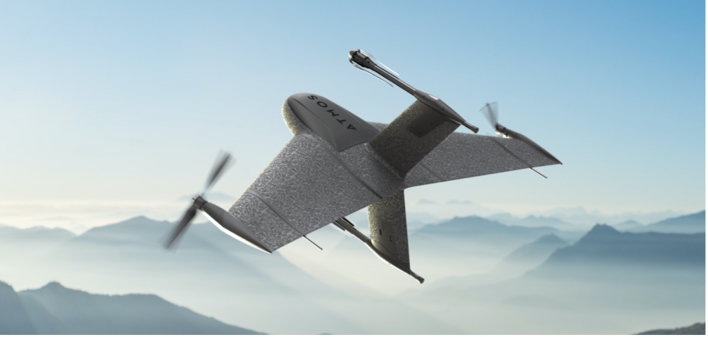
Atmos, a Dutch UAV manufacturer that develops high-end VTOL fixed-wing UAVs for mapping and surveying applications, expanded its global reseller network by signing a reseller agreement with Volatus Aerospace, a leader in commercial drones and UAV technology, in Canada.
Volatus will be responsible for the distribution of Marlyn Cobalt UAVs in Canada and will provide assistance and maintenance services to local UAV operators. The company brings extensive experience in aviation operations, safety, compliance and innovation to the evolving uncrewed aircraft market.
Marlyn Cobalt is the first fully autonomous hybrid (VTOL and fixed-wing) drone for mapping and surveying applications. With its patented design that combines the best of both worlds, Marlyn can take off vertically from anywhere and map fast and efficiently producing high-quality outputs for professional users. It is the only drone in its class that is built to perform even in harsh and windy conditions, while its easily swappable payloads provide operators with flexibility.
“We have an incredible team pushing the envelope on the entire spectrum of UAV technology,” said Glen Lynch, CEO at Volatus Aerospace. “The Marlyn Cobalt survey drone is an exciting new addition to our product offerings.”
The National Civil Aviation Agency (ANAC) of Brazil has approved beyond-visual-line-of-sight (BVLOS) flights using SenseFly‘s flagship eBee X fixed-wing drone.
ANAC’s decision means that the senseFly eBee X is officially approved for use in future BVLOS missions carried out by Brazilian drone operators. The drone received approval by demonstrating the safety requirements of the ANAC RBAC-E 94 Regulation for Unmanned Aircraft, through detailed engineering analyses and in-depth flight testing. Sensefly worked in collaboration with drone engineering and consulting specialists AL Drones and geotechnology company Santiago & Cintra.
Following the certification, senseFly eBee X operators in Brazil now only require a CAER (Special Airworthiness Certificate for RPA) waiver for the aircraft with Santiago & Cintra before flying BVLOS operations.
“The commercial drone industry in Brazil has been growing at a phenomenal rate. and we’re excited that the senseFly eBee X is at the forefront of these regulatory developments,” said Pierre-Alain Marchand, regulatory compliance manager, senseFly. “BVLOS is becoming an important tool for operators as they start to explore the potential of more advanced drone operations, and we’re pleased that our technology continues to help define frameworks and legislation in the country. Historic approvals passed in recent years has shown us that Brazil is one of the countries to watch for drone commercialization, so continue to watch this space!”
The authorization comes following approval of senseFly’s proprietary drone technology in 2017, where the use of drones for civil applications in Brazil were legislated as part of the RBAC-E94 regulation. SenseFly drones became the first and only in the country permitted to fly 400 feet in height with a 5 kilometer radius from a licensed pilot or observer, in contrast to previous VLOS operations that restricted use of drones to a 500-meter radius.
“The authorization of senseFly’s eBee X for BVLOS operations is another step towards commercialization of the sector,” said André Arruda, co-founder of AL Drones. “After years of collective hard work and effort from all parties, this certification presents a real opportunity for operators in the future to expand their mapping operations and achieve a robust return-on-investment. We look forward to seeing what this means for BVLOS operations in Brazil in the coming years.”
SenseFly’s eBee X fixed-wing drone is designed to suit a wide range of mapping jobs. At 1.6 kg (3.5 lbs.), eBee X is a lightweight, portable solution that is easy for a single person to operate. With an Endurance Extension option enabling a flight time of up to 90 minutes and single-flight coverage of up to 500 ha at 122 m (1,236 A at 400 ft.), the eBee X drone that offers users the high precision of on-demand RTK/PPK for achieving absolute accuracy down to 1.5 cm (0.6 in) without ground control points. This capability makes the eBee X suitable for BVLOS operations such as long corridor mapping missions for utility companies, expansive crop scouting in agriculture and by enterprise customers who desire a robust and professional drone fleet.
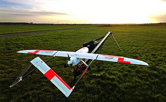
Launch of the RedKite drone. RedKite is a long-endurance sub-20-kg UAS designed to carry payloads of up to 5 kg. (Photo: Blue Bear Systems)
Blue Bear Systems Research Ltd. has successfully demonstrated a fully autonomous suite of multiple drone swarm assets under beyond-visual-line-of-sight (BVLOS) conditions.
The technology enables complex drone operations where multiple assets are able to carry out simultaneous tasks controlled by a single user to create a swarm effect.
The five fixed-wing drones clocked up to 15 hours of flying time, over four days, in challenging weather conditions. The swarm comprised a combination of Blue Bear’s Redkite and Cobra fixed-wing systems, which flew multiple simultaneous sorties from a test range in the northwest of England.
The drones were equipped with the latest automatic dependent surveillance-broadcast (ADS-B) technology, and the airspace was managed by Blue Bear’s airspace deconfliction software. All of the assets were controlled by a single operator from Blue Bear’s mission command control system in Bedfordshire, England.
“This is an exciting development for us, proving our ability to operate multiple drones, simultaneously, using the latest Blue Bear technology to deliver a swarm effect under BVLOS conditions,” said Ian Williams-Wynn, managing director of Blue Bear Systems.
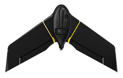
SenseFly, provider of fixed-wing drones, has launched the eBee X for mapping.
The eBee X, part of the Parrot Business Solutions portfolio, is designed to boost the quality, efficiency and safety of an operator’s geospatial data collection.
The eBee X. (Photo: senseFly)
It offers a camera to suit every job, the accuracy and coverage capabilities to meet the requirements of demanding projects, and is durable enough to work virtually every site, the company said.
“The eBee X is a giant leap forward for mapping technology and underscores senseFly’s position as the leader in the fixed-wing drone market,” said Gilles Labossière, executive vice president and COO of Parrot Group and senseFly CEO. “No matter what type of project a professional is undertaking, the eBee X has the coverage, data and accuracy capabilities needed to get the job done.”
The eBee X includes a range of cameras for jobs ranging from land surveying and topographic mapping to urban planning, crop mapping, thermal mapping, environmental monitoring and more. Cameras include:
The senseFly S.O.D.A. 3D: a unique drone photogrammetry camera with a one-inch sensor, which changes orientation during flight to capture three images (two oblique, one nadir) every time, instead of just one, for a much wider field of view. The result is stunning digital 3D reconstructions in vertically-focused environments—such as urban areas, open pit mines and coastlines—over larger areas than quadcopter drones can achieve. senseFly S.O.D.A. 3D is optimised for quick, robust image processing with Pix4Dmapper software.
The senseFly Aeria X: a compact drone photogrammetry camera with APS-C sensor. This rugged innovation offers an ideal blend of size, weight and DSLR-like image quality. Thanks in part to its built-in Smart Exposure technology, it provides outstanding image detail and clarity, in virtually all light conditions, allowing operators to map for more hours per day than ever before.
The senseFly Duet T: a dual-camera thermal mapping rig, which lets mapping professionals create geo-accurate thermal maps and digital surface models quickly and easily. The Duet T includes both a high-resolution (640 x 512 px) thermal infrared camera and a senseFly S.O.D.A. RGB camera with one-inch sensor. Both image sources can be accessed as required, while the rig’s built-in Camera Position Synchronisation feature works in sync with Pix4Dmapper photogrammetry software (optional) to simplify the map reconstruction process.
The eBee X is also compatible with the Parrot Sequoia+ multispectral camera for agriculture, the senseFly S.O.D.A. drone photogrammetry camera and senseFly Corridor for simple linear mapping.
The eBee X can meet the exacting requirements of every project. Its unique Endurance Extension option unlocks a flight time of up to 90 minutes (versus a maximum endurance of 59 minutes by default).
With this capability activated, the drone is able to achieve vast single-flight coverage of up to 500 hectares (1,235 acres) at 122 meters (400 feet), while the eBee X’s built-in High-Precision on Demand (RTK/PPK) function helps operators to achieve absolute accuracy of down to 3 centimeters (1.2 inch) — without ground control points.
According to senseFly, the eBee X allows users to work virtually every site, no matter how demanding, thanks to the drone’s built-in Steep Landing technology, ultra-robust design, live air traffic data and more, all backed by senseFly’s professional, localized support.
The eBee X is ideally suited to the varied and evolving needs of mapping professionals. These include: surveying and construction companies, quarry and mine operators, agronomists and forestry engineers, professional drone service providers, aerial imagery companies, environmental researchers and more, the company added.
The eBee X is supplied with senseFly’s eMotion flight planning and data management software.