Atmos has integrated the Sony a7R mark III and IV camera into its vertical take-off and landing (VTOL) fixed-wing UAV, the Marlyn Cobalt. This will increase coverage and accuracy achieved in a single flight for surveyors.
Both cameras have an ISO of 32,000, which is expandable to 102,400, and camera sensors with high megapixel count — 42,4 MP for the a7R III and 61 MP for the a7R IV. When combined with Zeiss’ 35 mm and 21 mm lenses, it enables UAV surveyors to achieve ground sample distance levels below one 1 cm.
The integration of the two cameras enables Marlyn Cobalt users to map an area of 210 hectares with centimeter-level accuracy in a single flight.
The ability to capture and evaluate truth on the ground through aerial imagery is an ever-growing industry, thanks to the proliferation of UAVs and access to imagery on demand and online. Yet obstacles remain that could prevent organizations from capturing location intelligence.
For organizations that require timely, accurate and current aerial imagery, an additional capture program outside of drones could be necessary. One company, Nearmap, flies fixed-wing aircraft two to three times per year over 430 urban areas across the United States. Using proprietary camera technology, Nearmap captures aerial data in a variety of formats: vertical, oblique and 3D. The location content is then delivered to customers via a web browser application and can be easily integrated into GIS/CAD applications.
A mid-size tech company in New Mexico using a drone to capture digital surface model data ran into two obstacles: proximity to no-fly zones at Albuquerque International Airport and need for image consistency over an entire metro area. With a project due date looming, the company turned to Nearmap, which provided the necessary image data around the airport, as well as historical imagery. With the Nearmap data, the company was able to speed project planning from design to project completion.
Nearmap aerial imagery also provides data at scale (an entire city, not one city block). The clarity of the imagery is 2.8-inch ground sample distance, providing optimal data for seeing truth on the ground.
Delair, a supplier of drone solutions for commercial industries, has introduced the next-generation of its high-performance DT26X Lidar UAV.
The DT26X is a long-range fixed-wing drone that combines highly accurate lidar sensing capabilities with an integrated high-resolution RGB (red, green, blue) camera, dramatically increasing the precision, efficiency and cost effectiveness of surveying and 3D mapping.
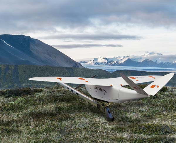
The Delair DT26X lidar drone combines lidar sensing with RGB camera data to enable highly accurate and high-resolution 3D representation and measurement over large areas with minimal flights and in challenging environments. (Image: Delair)
Details of the new model, which builds on Delair’s proven expertise in long distance, beyond visual line of sight UAV operations, were revealed at the International Lidar Mapping Forum in Denver.
Aerial-based lidar allows for extremely detailed and accurate collection of elevation data of the ground, even in large and vegetated areas, but is typically performed with specialized, single function platforms or expensive manned aircraft surveys with long lead times.
Camera-enabled drones offer a complementary solution for collecting imagery that can augment the lidar-based models. Most projects therefore require multiple mapping flights and separate UAVs, with initial missions using lidar sensors and subsequent flights equipped with RGB-cameras to enhance the digital rendering.
The Delair DT26X lidar’s combined payload of a lightweight sensor and integrated camera allows the acquisition of lidar and photogrammetry data in a single flight, which drastically reduces cost and immediately provides an extremely detailed digital model of the inspected assets.
The lidar sensor is specifically designed for UAV use, adding little weight or bulk to the Delair frame. The fully-integrated smart RGB camera enables real-time camera sensor control and in-flight photo review with automated quality checks.
The new platform delivers increased accuracy in 3D mapping and modeling of terrain and corridors in challenging physical environments (e.g. mountainous, inaccessible by road or foot, dense vegetation) and with difficult visibility, lighting or weighting conditions.
Its long range flying capabilities — allowing coverage of up to 2,400 square acres, communication range of 30 kilometers and 100 minutes of flight time — improve the efficiency of aerial mapping operations over large areas. As a result, the Delair DT26X lidar is well suited for uses such as environmental and land surveys, forestry monitoring, infrastructure surveillance, powerline and pipeline inspections, and road and rail construction.
“The combination of a sophisticated lidar sensor and an industrial grade RGB camera removes the ‘either/or’ decision of choosing between lidar and imagery data acquisition for geospatial professionals,” said Chase Fly, geospatial product manager at Delair. “This is the most versatile and cost-effective UAV solution for large area, long range mapping and surveying where accuracy and detail are required. It provides the precision and visibility required by the most demanding use cases and allows data acquisition and advanced digitization not possible through terrain-based or satellite 3D mapping techniques, or with limited short-range UAVs. With this configuration, users can acquire all the data required for a colorized point cloud from a single flight, which eases the point cloud classification process back in the office, saving significant time and money.”
New lidar sensor for more accurate mapping. TheDelair DT26X lidar fixed-wing UAV incorporates the new RIEGL miniVUX-1DL lidar sensor, a specially designed device for the needs of UAV use.
The small form factor sensor includes a downward looking and optimized field of view specifically geared for corridor mapping tasks. The wedge prism scanner construction produces a field of view of 46 degrees, and the circular scan pattern provides a very high point density and point distribution.
It offers a high scan speed of up to 150 scans per second and a measurement rate of up to 100,000 measurements per second. It is effective in penetrating poor lighting conditions or dense foliage. The lidar sensor makes use of RIEGL’s Waveform-lidar technology, allowing echo digitization and online waveform processing. It supports multiple-target resolution of up to five target echoes per laser shot.
“The new Delair UAV is typically the type of drone RIEGL had in mind when designing the RIEGL miniVUX-1DL, and represents another step toward completing our UAV lidar equipment product portfolio. The scanner’s specific wedge prism scanning mechanism generates a circular scan pattern, resulting in high point densities and therefore is especially well suited when deploying the scanner from fast moving acquisition platforms such as fixed-wing UAVs. The FOV (field of view) of the miniVUX-1DL is 46deg, resulting in optimized efficiency for downward-looking, linear acquisition set-ups like corridor mapping applications, for example. We are pleased to have such an innovative company like Delair as an esteemed OEM integration partner, bringing our sensing technology to key market sectors that require a flexible lidar solution,” commented Michael Mayer, managing director, RiCOPTER UAV GmbH.
RiCOPTER UAV GmbH is a subsidiary of RIEGL Laser Measurement Systems GmbH, an international provider of technology in airborne, mobile, terrestrial, industrial and unmanned laser-scanning solutions. RiCOPTER UAV GmbH commercializes RIEGL’s turnkey lidar UAV solution and laser-scanning payloads dedicated for UAV integration.
Post-Irma hurricane damage is captured in aerial imagery by EagleView.
EagleView Technologies has captured post event aerial imagery of two million properties in the state of Florida following Hurricane Irma.
EagleView is a provider of aerial imagery and property data analytics for government agencies, insurance carriers and other private-sector organizations,
With an image library dating back to 2002 in the state of Florida, EagleView is able to provide emergency services, public safety agencies, property assessors and county GIS departments with ample imagery from before and after Hurricane Irma occurred. Combining high-resolution imagery and advanced machine learning capabilities, EagleView can identify the severity of property damage following a hurricane or other extreme weather event.
“Hurricane Irma inflicted severe damage on properties all over Florida and affected millions of people throughout the state,” said EagleView President Rishi Daga. “With a view of more than two million properties in Florida, we are assisting the agencies that use our imagery with their efforts, so they can continue to help all of those who have been affected.”
The two million properties have been photographed via specialized camera rigs in fixed-wing aircraft. The images are taken from an orthogonal (top-down) perspective as well as at oblique angles from all four cardinal directions. Oblique aerial imagery enables insurance claims adjusters to view all sides of a home’s exterior and gives emergency response crews greater insight into the storm’s effects in their communities.
“Our goal was to begin capturing and processing imagery as soon as possible to assist in recovery efforts, and we have done so at record speed,” said Jay Martin, Senior Vice President of Operations at EagleView. “Our next phase is to put boots on the ground and complete property inspections up close using drones as part of our EagleView OnSite solution.”
Post-hurricane image capture and processing will continue to take place throughout the upcoming weeks.
EagleView is completing the phase of image capture via fixed-wing aircraft and will soon move in to completing property inspections with the use of unmanned aerial systems (UAS), bringing post-event data directly to insurance claims adjusters.
As of Sept. 18, thousands of drone inspections have been scheduled through Friday, Sept. 22.
According to a new TechSci Research report, the commercial drone market is projected to grow at a CAGR of 27 percent until 2021, with North America anticipated to continue its dominance as the largest commercial drone market through 2021.
According to the report, the rotary-blade drone segment dominated the global commercial drone market in 2015 because of its various technical features and benefits that enable these drones to perform intensely in photography, mapping, oil and gas sector and mining industry.
Moreover, continuing growth of the global mining market, which was valued at around $1.5 trillion in 2015 and is projected to grow at a CAGR of more than 7 percent during 2016-2021, is expected to further boost the prospects of commercial use of drones in the mining sector over the next five years. Rotary blade drones are designed to fly in all directions as well as hover at a fixed position.
In 2015, these drone types accounted for a market share of more than 75 percent in the global commercial drone market because of their versatility and increasing application areas.
Fixed-wing drones are the other major drone type, and these drones are being widely used in precision agriculture and aerial mapping. Precision farming utilizes several technological advancements such as geo location tracking, data management, and crop health analysis in order to ensure better productivity as compared to conventional farming methodology.
Higher profitability and productivity, coupled with expanding global demand for crop yield are few of the factors poised to drive the global precision agriculture market at a CAGR of over 11 percent during 2016-2021, thereby propelling demand for drones used in the precision agriculture industry.