“Topcon provides high-precision GNSS positioning technologies for geomatics, construction and agriculture applications worldwide,” explained Ron Oberlander, head of the Topcon Geomatics Platform. “Working with companies such as Fixposition — specialists in visual RTK (real-time kinematic) and visual-aided positioning — helps create added value for our customers.
According to Topcon, its customers are increasingly working in environments where satellite connection can be challenging, such as dense urban environments, and need consistent, reliable positioning to maintain productivity. Fixposition offers technology that augments satellite positioning, beneficial for users even while working inside structures and in indoor-outdoor transitions, without disrupting workflows by combining RTK GNSS with artificial intelligence to ensure position accuracy. “We see this AI-enabled technology as an innovative integration with our next-generation GNSS solutions,” Oberlander said.
“We’re proud to supply Fixposition’s xFusion, vision and multi-modality fusion positioning technology to support Topcon’s next-generation GNSS solutions,” said Zhenzhong Su, CEO and co-founder of Fixposition. “We look forward to bringing this new solution to market — helping surveying professionals across geomatics, construction and agriculture deliver faster results and get more done without compromising quality, even in GNSS-challenging environments.”
Fixposition has been integrating Topcon RTK corrections into its Vision-RTK sensors since 2023, when the companies announced an agreement providing Fixposition customers in North America and Europe with access to the Topnet Live RTK corrections service network.
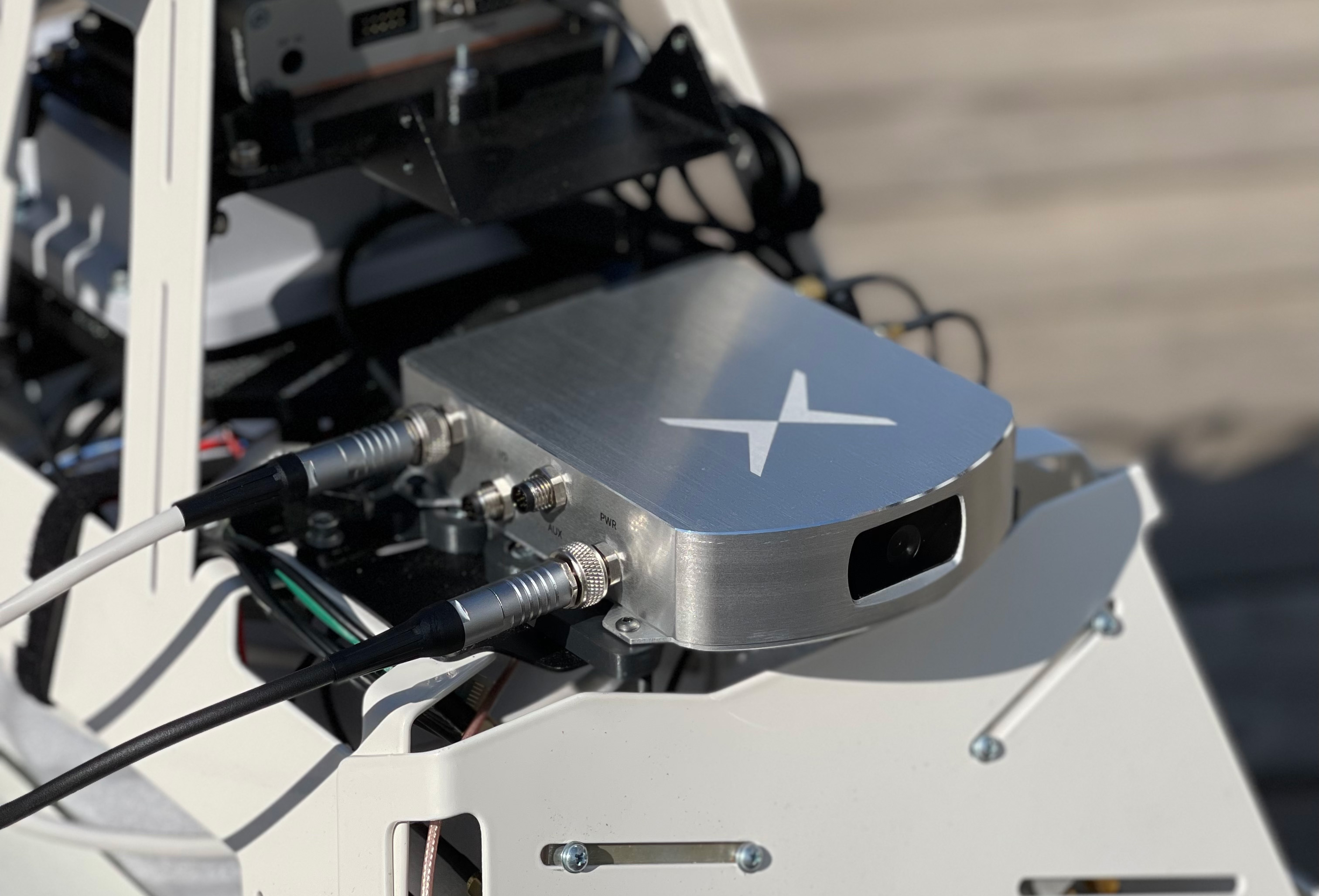
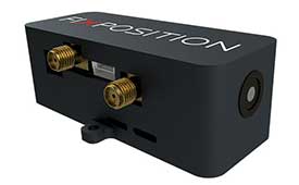
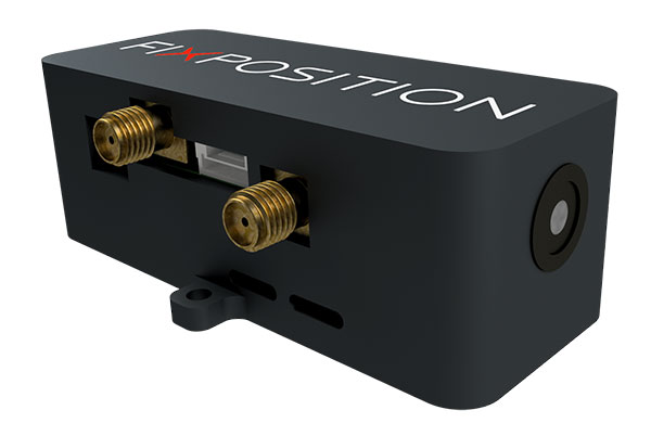
Fixposition, a Swiss technology company providing high-precision positioning solutions, has released a centimeter-level positioning sensor, the Vision-RTK 2.
The low power and compact, industrial-grade device is suitable for autonomous delivery and logistics vehicles, agriculture, mowing and landscaping machines, as well as any other application where precise, uninterrupted positioning must always be available everywhere.
“As vehicles and machines become increasingly autonomous, they must safely and precisely negotiate complex routes, even where GNSS visibility is degraded or blocked,” said Zhenzhong Su, CEO and co-founder of Fixposition. “With Vision-RTK 2, these applications are becoming possible. Our deep sensor-fusion technology combines GNSS technology with advanced computer vision and machine learning.”
“We are using a global optimization-based sensor fusion technique that is much more robust and powerful than traditional Kalman filters,” said Lukas Meier, CTO and co-founder of Fixposition. “Our computer vision-based dead-reckoning technology has clear advantages over purely IMU-based products.”
A roundup of recent products in the GNSS and inertial positioning industry from the December 2020 issue of GPS World magazine.
OEM
Inertial system
Ready for UAVs, robotics
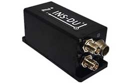
Photo: Inertial Labs
The INS-DU is a high-performance strapdown inertial navigation system (INS) that determines position, velocity and absolute orientation of a platform it is mounted to. Its dual-antenna u-blox receiver provides 1-cm real-time kinematic (RTK) position from RTCM 3 RTK corrections and supports multiple GNSS constellations. Designed for UAVs, land vehicles and marine vessels, the INS-DU uses a range of aiding data to deliver a highly accurate solution for GNSS-denied environments. It uses a miniAHRS with 3-axes each of precision magnetometers, accelerometers and gyroscopes to provide orientation. It contains algorithms for the motion of robots, autonomous vehicles and antennas.
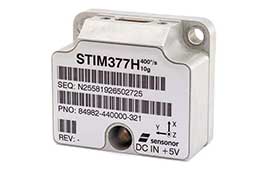
The high-accuracy tactical-grade STIM277H gyro module and STIM377H inertial measurement unit (IMU) were designed to meet space segment needs. Both have hermetic aluminum enclosures, and all parts are tested for fine and gross leak to conform to MIL-STD-883J, Class H. While a commercial off-the-shelf (COTS) product, Sensonor has carried out extensive radiation characterizations. The design is tested for a 20+ years operating life through high-temperature operating life (HTOL) testing. Backwardly compatible with Sensonor’s other IMU and gyro modules, STIM277H and STIM377H are designed for satellite attitude and orbit control systems (AOCS), launchers, portable target acquisition systems, UAV payloads, land navigation systems, turret stabilization, missile stability and GNSS-supported navigation systems.
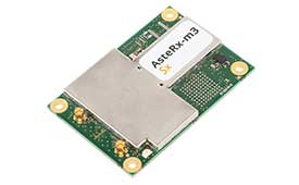
The AsteRx-m3 family features GPS/GNSS OEM boards optimized for power consumption and ease of integration. An easy-to-integrate design enables short set-up times and faster time-to-market. The AsteRx-m3 offers multi-frequency, multi-constellation positioning combined with Septentrio’s GNSS+ technology while optimizing power. The AsteRx-m3 Pro rover receiver tracks signals from all available GNSS constellations on three frequencies, and operates both in single- and dual-antenna modes. The AsteRx-m3 ProBase is designed to operate as a reference station for RTK and PPP-RTK networks. The AsteRx-m3 Pro+ is a full-feature OEM receiver board flexible enough to fit into any application and to be used either as a rover or a base station in a single- or dual-antenna mode.
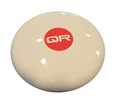
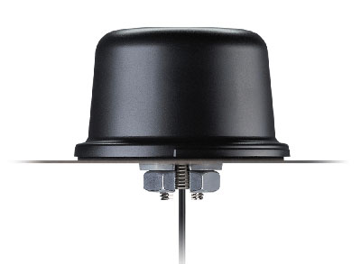
New anti-jamming antennas available are the QR200 GPS dual-frequency L1/L2 anti-jamming antenna, the QR201 GNSS multi-frequency band anti-jamming antenna, and the QR202 GNSS multi-frequency band anti-jamming antenna with additional L-band reception (1520–1560 MHz). All models provide robust GPS or GNSS navigation and block intentional jamming and unintentional RF interference timing or 3D positioning. All three are lightweight (230 grams for the QR1xx series and 500 grams for the QR2xx series) with low power consumption (1–1.5W typically, depending on configuration), and can be mounted on any platform (cars, poles, drones, etc.).
The Vision-RTK positioning sensor is a compact centimeter-accurate solution with high reliability and availability in challenging environments. The module integrates two real-time kinematic (RTK) GNSS receivers and visual inertial navigation. Its sensor-fusion algorithm is based on deep integration of GNSS, camera and inertial sensors. Real-time sensor fusion provides centimeter-accurate absolute positioning in any outdoor environment.
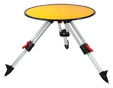
Deploying ground control targets on accurately surveyed ground control points (GCP) assures that a UAV lidar survey has been properly executed. UAV lidar surveys are typically undertaken in remote, rural and sometimes hazardous locations where no fixed points are available, such as solid surfaces or concrete features. Routescene’s GCPs are raised from the ground using a mini tripod. A built-in bubble level enables accurate leveling and removes the need for a tribrach. Robustly engineered, the targets stay in position during adverse and windy conditions, reducing the risk of repositioning during a survey. They are covered with highly retro-reflective material to provide high-intensity returns. As a result, the targets are easily identifiable and can be automatically extracted from the geo-referenced point cloud.
The Toughbook A3 Android tablet is aimed at the mobile workforce. It has an outdoor viewable screen and patented rain-touch functionality. With a 10.1-inch screen and 6-foot drop rating, the A3 enables users across industries to tackle tough jobs and critical applications. The Qualcomm SDM660 chipset, which supports BeiDou, Galileo, GLONASS, GPS, BeiDou QZSS and SBAS. 4G LTE Band 14 EM7511 multi carrier mobile broadband with GPS. The tablet has a powerful octa-core processor, an optional integrated barcode reader, an insertable smart card reader and an insertable stylus. The A3 has a 5-foot drop rating and IP65 certification for dust and water resistance.
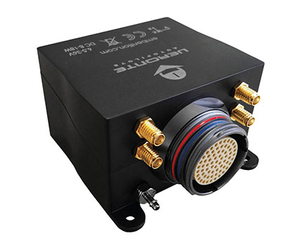
Veronte Autopilot 1X is a miniaturized avionics system for advanced control of unmanned systems. The control system embeds a suite of sensors and processors with datalink radio, with reduced size and weight. The control system Veronte Autopilot 1X adds fully autonomous control capabilities to any unmanned system for complete operation. The Veronte control system is fully configurable for payload, platform layout, control phases and control channels. It uses real-time kinematic (RTK) positioning and provides cloud connectivity, sense-and-avoid support, electromagnetic interference and vibration isolation.
The Astro commercial drone platform is equipped with Freefly’s multi-band, real-time kinematic (RTK) system, which provides centimeter-level precision with a u-blox F9P GNSS module. The drone is equipped with a 60-megapixel Sony camera. A customized version of Skynode powers each Astro, providing LTE connectivity, an onboard Linux mission computer, and seamless connectivity to Auterion Mission Control and Cloud Suite. The Auterion ecosystem provides robust, secure and scalable drone planning, flight and compliance management solution.
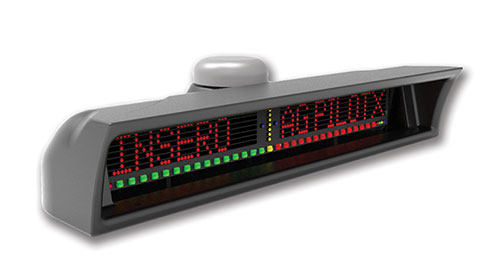
The guidance system AgPilotX for aerial applicators uses three wireless components: a GPS/GNSS lightbar, a hub and an Apple iPad. The smart components run off their own computer, communicating to each other wirelessly. The AgPilotX Smart Lightbar has onboard GPS+GLONASS as well as a GNSS antenna, so there is no need to run an antenna up to the aircraft canopy. The Lightbar logs the data, while a hub connects the switches (swath advance, swath decrement, spray on/off) and peripherals, and an iPad runs the interface software through an Apple App. All logs are saved as unique jobs and can be returned to at any time. The lightbar is not dependent upon the iPad to operate and will continue to work the active job even if you start using a different App or even shut the Apple device completely off.
Insero, inserosolutions.com
Antennas
High accuracy for autonomous vehicles, robotics
The Colosseum X XAHP.50 antenna. (Photo: Taoglas)
Two new active, multiband GNSS antennas are engineered for applications that require critical high-accuracy positioning and timing, including autonomous driving and precision agriculture. The MagmaX2 AA.200 is designed for space- and weight-constrained applications, such as robotic lawnmowers. Embedded versions are also available. It is a low-profile active multiband GNSS magnetic mount antenna for use across most major constellations including GPS (L1/L2/L5), GLONASS (G1/G2/G5), Galileo (E1/E5a/E5b) and BeiDou(B1/B2). The Colosseum X XAHP.50 is a geodetic-quality small-dome antenna suitable for a vehicle roof mount or pole mount. It is engineered to operate with high-precision capabilities on the full GNSS spectrum. Sub meter positional accuracy better than 55 cm is achievable, even without the use of RTK correctional services.
Vision-RTK enables applications in previously unreachable areas and unlocks new possibilities for autonomous ground robots and drones
At this year’s Intergeo Digital event, taking place Oct. 13-15, Fixposition is debuting the Vision-RTK positioning sensor, a compact centimeter-accurate solution with high reliability and availability in environments that are challenging for traditional GNSS.
Photo: FixPosition
The Vision-RTK’s sensor-fusion algorithm is based on the deep integration of satellite, camera and inertial sensors, and enables unprecedented reliability and availability in diverse and challenging applications, the company stated.
“The highly integrated nature of our Vision-RTK sensor and our deep expertise in computer vision and real-time kinematic (RTK) GNSS enabled us to implement completely new approaches in sensor fusion, resulting in previously unseen performance,” said Lukas Meier, CTO and co-founder of Fixposition.
Traditional GNSS sensors suffer from limited reliability in GNSS-challenging and denied areas. On the other hand, standalone computer vision is sensitive to light conditions (such as snow, strong sunlight and rain) and struggles in situations where there is a lack of features such as cornfields and grass. Errors accumulate over time with standalone inertial technology, causing large drifts.
As a result, devices using either sensor are limited in their range of operation and are likely to fail in certain conditions. Fixposition’s solution increases the potential of these sensors with its unique sensor-fusion technology by increasing the trustworthiness of the positioning accuracy and the range of operation in different environments.
The real-time sensor fusion provides centimeter-accurate absolute positioning at any time, in any outdoor environment. This small module integrates two RTK-GNSS receivers and visual inertial navigation, and is suitable for applications where size and accuracy are of paramount importance.
The dual-receiver configuration, together with Fixposition’s advanced algorithms, provides a true-heading output and increased resistance to electromagnetic radiation.
The sensor provides USB and Wi-Fi connectivity and a web interface. It enables straightforward integration in state-of-the-art autopilot control systems for drones and robots. It’s also plug-and-play compatible with platforms such as PX4, ROS and Apollo.
For ground robotics and drones applications, Vision-RTK increases the device uptime and efficiency while enabling new market segments in areas previously inaccessible. For end-device manufacturers, this technology eliminates the need for an in-house development of advanced localization solutions, shortening their sales cycle and reducing costs and investments.
Visit the Fixposition booth and meet the team at Intergeo Digital 2020 to learn more about the Vision-RTK sensor.
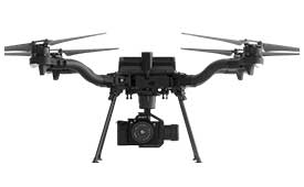
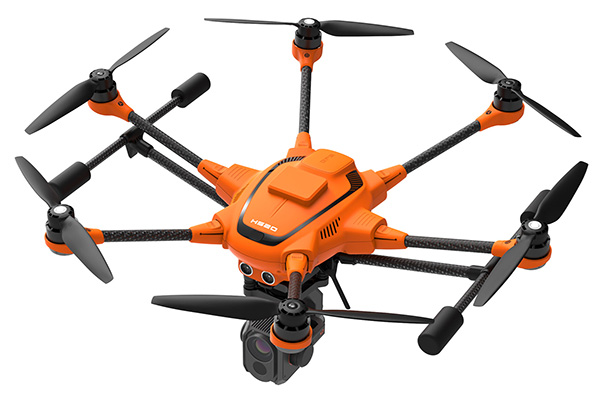
Yuneec International’s commercial hexacopter, the H520, will now optionally be available with an RTK (real-time kinematic) system from the Swiss company Fixposition.
Under difficult GPS conditions, such as in cities or canyons, the RTK system ensures maximum precision and centimeter-precise positioning. The fully integrated RTK satellite navigation enables extremely accurate recurring images and faster 3D mapping. It also makes automated inspection flights easier and more precise, the company said.
The new H520 RTK is suitable for commercial applications that require maximum precision. By using RTK technology, the H520 can now fly much closer to objects for inspection as the UAV positions itself precisely in the centimeter range (1 cm + ppm horizontal / 1.5 cm + ppm vertical) rather than in the meter range, which is standard for the H520.
This accuracy is paramount for applications where several images need to be taken at the same location on different days including:
documenting progress on construction sites,
inspecting mountain landscapes to prevent natural hazards such as rock falls or avalanches, and
forensic accident scene reconstruction.
In addition, the satellite navigation system makes it possible to significantly reduce image overlaps, which means fewer photos and shorter model calculation times, maximizing efficiency in workflows.
The RTK system is not only fully integrated into the hardware, but also into the UAV’s software. This means the user retains the full range of functions of the DataPilot software, including mission flights.
The H520 RTK works with two components: the RTK module on board the H520 and a base station on the ground. For precise navigation, the module supports constellations of up to three different satellite systems from GPS, GLONASS, Galileo and BeiDou.
If the use of a ground station is not possible, the system can also be operated with a national reference station network (network RTK). The network RTK is provided by third-party providers and requires an internet connection, such as a mobile hotspot. All data including satellite data is recorded, which makes the H520 RTK suitable for post-processed kinematics (PPK).
The H520 RTK will be available in the second quarter of 2019. Technical specifications are available here.