Tag: fleets

  • FreeFlight SBAS/GNSS receiver chosen for USAF helicopter fleet

    FreeFlight SBAS/GNSS receiver chosen for USAF helicopter fleet

    A FreeFlight Systems SBAS/GNSS receiver has been selected to provide ADS-B position source information as a part of an upcoming ADS-B modification and compliance program for the United States Air Force HH-60G helicopter fleet.

    Strategic Enterprise Solutions Corp. (SESC) of Warner Robins, Georgia, was awarded the modification program, which includes installation of the 1203C SBAS/GNSS receiver and the AN/APX-119 Mode S Extended Squitter transponder with Mode 5 capability to provide a complete ADS-B Out solution for more than 100 helicopters.

    An HH-60 Pave Hawk helicopter lands in Afghanistan; a UH-60 Blackhawk is in the background. (Photo: (U.S. Air Force photo/Senior Airman Brian Ferguson)
    An HH-60 Pave Hawk helicopter lands in Afghanistan; a UH-60 Blackhawk is in the background. (Photo: U.S. Air Force photo/Senior Airman Brian Ferguson)

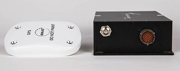
    The FreeFlight Systems 1203C SBAS/GNSS receiver is a certified, high-integrity position source in a compact, lightweight package that was designed to be modular and able to be integrated with various other avionics.

    The 1203C pairs seamlessly with certified Mode S Extended Squitter transponders for a fully rule-compliant ADS-B Out system, FreeFlight said.

    More than a war hawk. The primary mission of the HH-60G Pave Hawk helicopter is to conduct day or night personnel recovery operations into hostile environments to recover isolated personnel during war.

    The HH-60G is also tasked to perform military operations other than war, including civil search and rescue, medical evacuation, disaster response, humanitarian assistance, security cooperation/aviation advisory, NASA space flight support, and rescue command and control.

    The 1203C in service. With several hundred 1203Cs in service across airline transport, military, business aviation and rotorcraft platforms, these receivers are known for their high performance, ease of installation, operational reliability and longevity, FreeFlight said.

    The 1203C SBAS/GNSS receiver and antenna (Photo: FreeFlight Systems)
    The 1203C SBAS/GNSS receiver and antenna (Photo: FreeFlight Systems)

    The 1203C can also serve as the approved position source for select manufacturers of TAWS/FMS, RNP and other NextGen applications, and allows customers to take advantage of the operational and safety benefits provided by the NextGen airspace transformation without the need for extensive and costly avionics upgrades.

    With the ADS-B mandate now only 17 months away, aircraft operators need to prioritize ADS-B installations.

    Significant portions of today’s airline, business, and military aircraft fleet will remain in service long after 2020, and in many cases an STC’d retrofit solution comprising of a transponder upgrade and the addition of a dedicated SBAS/GNSS receiver like the 1203C is the simplest and most cost-effective way to achieve mandate compliance, FreeFlight said.

  • Sygic adopts what3words address system for fleets

    Sygic-screenshot-what3words-WSygic is partnering with innovative addressing system what3words.

    According to Sygic, its business solutions and consumer apps are used by more than 200 million drivers and 2,000 fleets worldwide including Amazon. Sygic is also the first GPS app to partner with Ford.

    The partnership will initially focus on Sygic’s business solutions for taxi, public transport, delivery and construction clients with the aim of a wider integration into Sygic’s commercial products. Clients will be able to turn on three-word addressing within their existing solutions in the coming months.

    what3words is a location reference system that has divided the world into 57 trillion 3 x 3-meter squares, each with a unique three-word address. For example, “///droplet.outings.panel” will take you to the front door of Sygic’s headquarters in Bratislava.

    “Sygic is committed to exploring the boundaries of navigation, a philosophy that has directly contributed to our enduring reputation as the leader in navigation,” said Martin Strigac, Sygic CEO. “what3words is the simplest way to talk about location and its rapid adoption across sectors means it is quickly becoming a standard. To get from A to B,, you need a map, navigation and to know precisely where A and B are. With what3words, we can now offer a world-class solution across all of these.”

    “In-car navigation relies on an antiquated street and postal address system that is no longer fit-for-purpose,” said Chris Sheldrick, CEO and co-founder of what3words. “Poor addressing leaves drivers frustrated and means businesses waste millions every year. We are delighted to partner with Sygic to offer their business customers a more efficient solution to the last-mile challenge.”

    Sygic featuring what3words will be showcased at the Post & Parcel Conference, being held March 20-22 in Berlin.

  • Are drones the future of marine surveying?

    Are drones the future of marine surveying?

    Drones are quickly becoming a staple of the maritime industry. In January, the European Maritime Safety Agency (EMSA) issued the largest ever civilian maritime drone contact, valued at €67 million.

    Under the contract, drones will be used to assist with border control, search-and-rescue operations and monitoring of pollution, as well as the detection of illegal fishing and drug and people trafficking.

    External Vessel Inspections. Big names in the maritime industry such as DNV-GL, Lloyds Register and Maersk have all shown strategic intent to revolutionize their operations by embracing drone technology, and many maritime operators are now following suit.

    All ship owners know that traditional methods of external vessel inspection can be a costly affair. Now that high-definition, camera-equipped drones are widely available and affordable, it is becoming more common to use them for external vessel inspections to assess structural conditions. Identifying substantial corrosion, significant deformation, fractures, damage or other structural deterioration can be done quickly, easily and cost-effectively using drones.

    Tank Inspections. The visual inspection of cargo tanks was traditionally performed by workers suspended on ropes to inspect the tank structure. The sheer size of modern-day vessels means that access methods including staging, rafting and climbing are often used by surveyors to access tanks.

    In contrast, drone surveys require no human access to the tank and, since no access equipment is required, there are no setup costs, and inspections can be completed within a quicker timeframe.

    Martek Marine’s V-200 UAS. (Photo: Martek Marine)

    Bathymetric Surveys. Accurate and reliable information on the features of water bodies and their shorelines is vital to navigational safety. Bathymetric surveys gather the information, which is then published for use on nautical charts. Rather than using a fixed-wing airplane or helicopter, bathymetric sensors developed for drones allow this type of survey to be carried out flexibly and at a fraction of the cost.

    To operate effectively in the harsh maritime environment, the technology has been developed to withstand storm force wind and heavy rain, snow and salt spray.

    As technology advances, so does the flight time available on drones, meaning more area can be covered in a quicker timeframe.

    Floating Flare-Tip Inspections. Drone surveys typically exist to provide close visual and thermal inspections of high, live or difficult to access structures offshore, and there’s nothing more challenging to access than a flare tip, 70 meters above water, on a floating production facility.

    Drone survey inspections for flare tips remove the need for a shutdown to inspect the flare and offer reduced costs compared to aerial surveys carried out by helicopter or plane.

    Offshore Wind Energy. The wind energy sector is growing fast. Storm force winds, erosion, lightning strikes and even build-up of insects can have an impact on turbines, and blades need to be inspected for deterioration. Inspectors have traditionally had to scale the turbines with the help of ropes and cables.

    The maritime surveying company Martek Marine uses a drone fleet designed for turbine-blade inspections onshore or offshore. Qualified and trained pilots quickly and accurately identify and assess faults.

    Traditional surveying requires turbines to be offline for two hours up to a day, but Martek’s inspection process reduces this time to 45 minutes.

    Following the inspection, the client can access the data through Martek’s secure, cloud-based asset management portal where they can download a detailed PDF report and access raw survey data.

    Fully Autonomous Drones? Fully autonomous drones could be the next big thing for maritime surveying. The drones can be pre-loaded with a 3D model of the ship. This allows the drone to autonomously work its way around the vessel, stopping at points of interest to obtain detailed video or image data.

    Advancing this further, a drone could be designed to create its own 3D map of the vessel before carrying out the survey independently.

    This article is excerpted from a blog by Martek Marine, a UK-based maritime surveying company. Read the full blog, with more details and examples.

  • Lockheed, Warsaw U demonstrate UAV fleet command and control

    Lockheed, Warsaw U demonstrate UAV fleet command and control

    Lockheed Martin and the Warsaw University of Technology (WUT) successfully demonstrated their UAV optimization technologies using aerial command and control (C2) of multiple unmanned aerial vehicles (UAVs).

    The demonstration marks a successful milestone in the joint WUT-Lockheed Martin advanced applied research program on optimization of diverse fleets of aircraft, and concepts associated with manned-unmanned command and control of airborne platform systems.

    “These technologies have tremendous commercial and military potential as the world moves toward greater and greater use of unmanned aerial systems,” said Prof. Janusz Narkiewicz, head of WUT’s Department of Automation and Aeronautical Systems. “Understanding how different assets can interoperate, communicate and serve common objectives with maximum efficiency is a challenging task in the growing field of UAV technologies.”

    Through the use of advanced mathematic calculations and a systems-of-systems approach, the technology bolsters mission efficiency by adapting the fleet’s commanded flight paths, speeds, division of duties and sensor performance. Modeling all the constraints of the task at hand, the students calculate the “best answer,” usually beating either the human best guess or simpler approaches by 10 to 20 percent.

    Lockheed-WarsawU-UAV-WThe goal of the team’s latest project was to advance previous optimization work by incorporating airborne C2, improving user interfaces, and testing new methods for related subroutines. With a vision of ultimately developing fast dynamically adaptive approaches to live management of a UAV fleet, this work is an important contribution to the concept of manned-unmanned teaming, where manned assets operate seamlessly with surrogate UAVs, often controlling many at a time against specific tasks.

    The technology demonstrates that, with the right tools, an operator may adapt to changing scenarios, calculate new solutions, and deploy those new, optimized solutions to the fleet of commanded aircraft, whether for civil or military purposes, a Lockheed Martin news release said.

    The recent demonstration can be equated to a search-and-rescue task, where every minute shaved off of a search pattern could be the difference between life and death.

    In another example, if UAVs were to be used to deliver small packages to consumers, the 10 to 20 percent performance improvement could be the competitive edge that keeps an operation in business ahead of the competition.

    The program builds on the strong industrial and academic partnership between Poland and Lockheed Martin aimed at motivating young Polish engineers to address tomorrow’s defense and industrial needs. WUT and Lockheed Martin are seeking new Polish partners to further advance Polish research and development capabilities on manned-unmanned airborne platform system integration.

    A video about the program is available here.

  • Azuga expands sales operations for connected fleets

    Photo: Azuga
    Photo: Azuga

    Azuga, a provider of connected vehicle technology, expanded its sales operations to serve more than 100 fleets in 10 countries across Latin America, Europe, India and parts of the Middle East, the company announced in a news release.

    “Our next-generation, easy-to-use connected vehicle solutions are now disrupting the fleet telematics market internationally with driver-friendly fleet telematics, dramatically lower costs and country-specific customizations,” says Ananth Rani, co-founder and president of Azuga. “Azuga’s expanded presence was made possible in partnership with Danlaw, a global provider of OBD II hardware with vehicle compatibility that’s unmatched in the industry. Millions of miles of road testing across the globe have given Azuga the platform for this international expansion. ”

    [RELATED: Learn more about the company’s inception and its co-founder,  from the 2015 CTIA Super Mobility show: Azuga Founder Rani Brings Gamification to Fleet Management]

    In six months, Azuga has successfully helped Whirlpool Mexico’s home service technician division improve customer service and increase overall productivity. The company’s easy-to-install technology allowed for a very quick implementation into the fleet’s 100 vehicles, the company says. The fleet has saved Whirlpool 500,000 pesos per year in maintenance, fuel and operational costs.

    With its roots in Detroit, the Silicon Valley-based telematics company couples automotive industry experience with leading technology and innovation in order to provide a suite of game-changing fleet solutions, according to the news release. The solution combines traditional GPS fleet tracking with driver visibility, gamification, employer-funded rewards, social sharing and Azuga-funded awards. Those additional social telematics driver-centric features have enabled fleet managers to experience significant and positive shifts in company morale, as well as an increase in overall ROI, the company says.

    “We selected Azuga for its painless and quick installation and implementation as well as its geofencing and driver safety features,” said Tim Whittaker director of Leamoco, one of the UK’s leading car part specialists. “We are really excited that we had an option in the UK that allowed us to easily access rich engine and driver behavior data as well as gamification of the driver experience. This ensures we can improve and exceed customer expectations on delivery times, and continue to improve efficiency and safety across the fleet. Having had time to use this system properly, and seeing the positive impact it has had on the business, I can state that it has delivered all that we hoped for. We now wouldn’t be without it.”

    Azuga’s connected vehicle solution for fleets is available internationally from select partners and resellers.

  • Fugro awarded three-year positioning contract for seismic fleet

    Fugro awarded three-year positioning contract for seismic fleet

    Fugro has been awarded a three-year contract by PGS for the provision of precise satellite positioning systems for its seismic vessel fleet. PGS is a leading global provider of marine seismic and electromagnetic services, data acquisition, imaging, reservoir services and multi-client library data.

    Fugro, provider of precise satellite positioning to the offshore oil and gas industry, will supply PGS vessels with a number of independent GNSS. These systems include Fugro’s recently launched Starfix.G4 — a commercial GNSS service to utilize all available GNSS systems (GPS, GLONASS, Galileo and BeiDou), giving sub-decimeter accuracy — and Starfix.G2+, a global service offering centimeter accuracy in both position and height.

    In addition to precise vessel positioning, PGS will benefit from a new generation of positioning technology for their seismic sources and tailbuoys. Meeting the high demand for robustness and quality in the offshore industry, this proactive technology provides independent decimeter and centimeter positions and heights for remote (seismic source and tailbuoy) operations.

    Cerys James, vice president technical at PGS, remarked, ”Reliable, precise positioning technology is essential for modern seismic operations. The solution supplied by Fugro will ensure our entire fleet has highly accurate vessel positioning, along with precise source and streamer positioning.”