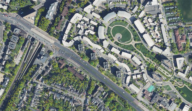
Birmingham City Council has launched a mapping portal to address the issue of tree equity across the city.
With UK national tree map data, created by aerial mapping company Bluesky International, the interactive tool allows users to identify which parts of the city have lower than average tree canopy cover and investigate possible relationships between canopy cover and other socio-economic and environmental factors. The online platform also enables users to model different scenarios and targets to identify planting opportunities and locations to increase the number of trees.
The national tree map was created using innovative algorithms and image processing techniques, from the most up-to-date aerial photography and terrain data for the whole of Great Britain and Ireland. It provides a detailed reference as to the location, canopy cover and height of trees 3 m and taller that can be applied alongside other data to establish ownership, proximity to other features or assets, and relationships between demographic, economic or social data.
National tree map data is widely used by a number of different market sectors such as local authorities, energy companies, property developers and academic and research organizations, investigating the role of trees and green spaces and their impact on health, environment and infrastructure.
Airbus Defence and Space has launched The OneAtlas Platform, a collaborative environment to access premium imagery, perform large-scale image processing, extract insights and benefit from Airbus assets for solution development.
OneAtlas is offering a 30-day free trial, giving customers streaming access to imagery, sample change detection reports, and global imagery and data layers, including the basemap and the WorldDEM.
Besides access to a comprehensive archive with premium imagery, users can try services such as:
Ocean Finder for the maritime industry
Verde for precision agriculture
Starling for forest management
Earth Monitor for tracking changes over an area of interest
The developer portal provides more information through API documentation and discusses how to benefit from the imagery either in streaming or download format.
The Ocean Finder provides a satellite-based maritime ship detection service. (Photo: OneAtlas)
The startup PlanetWatchers has developed Foresights, a risk management and geospatial analytics platform designed specifically to help clients manage forestry assets quickly, effectively and accurately.
Foresights identifies areas of new or potential risk, and delivers operations tracking and forest damage management services. The company plans to add satellite-driven analytics, inventory data and forest productivity services to the platform. before the end of the year.
The Foresights platform covers larger geographic areas and delivers results faster and more accurately than traditional project-based companies, traditional inventory methods and off-the-shelf processing tools, the company said.
PlanetWatchers combines multi-source satellite imagery data, topography maps, soil maps, meteorological data and near real-time ground input from operational teams to deliver optimized insights. The tool is capable of detecting disturbances as small as 0.1 ha (0.25 ac) related to pest, disease and drought damage.
Foresights will help forest managers “easily access crucial business intelligence and detailed insights and analytics on a regular basis so they can make proactive and informed decisions and take immediate remedial action,” said Ariel Smoliar, PlanetWatchers’ CEO and co-founder. “Without these higher levels of data and improved frequency of information, they could see negative impacts on their forestry management decisions, their supply chains and, ultimately, their profits.”
Reports identifying locations that require immediate mitigation can be viewed in existing GIS systems and are geolocated for forestry field teams, including offline capabilities for teams operating in remote areas without cellular reception.
“Foresights also fills a data gap known as the ‘Last Mile of Analytics’,” Smoliar said. “When we deliver satellite images to our clients, they shouldn’t have to then analyze and extract information. We remove this pain point for them by providing deep analysis of optical and radar satellite images, and compiling actionable insights and reports, including detailed maps of locations of interest. Our clients are shown not only the location of the disturbance, but also the issue and its cause, granting them vital intelligence they can act on with very little lag time. Foresters will no longer need to process or analyze imagery: this is the game-changing value of the Last Mile of Analytics.”
The Forest Operations service provides foresters with insights to track progress of various forest harvest operations such as thinning and clearcutting. This information assists operations managers in optimizing their wood supply chain and efficiently and effectively managing resources.
The Forest Disturbance service delivers location-specific reports to forest owners and managers detailing areas with identifiable disturbances that could degrade the quality, yield, and profitability of forests. Some disturbances that Foresights can identify to help commercial foresters respond proactively include growth and uniformity issues over time, illegal logging, insect infestations and disease, competitive vegetation, storm damage, drought, wildfires and more.