Tag: Fortem Technologies

  • DJI drones cleared for government use, plus more UAV news

    DJI drones cleared for government use, plus more UAV news

    There is a lot of UAV action taking place this month. An anti-drone defensive system is being trialed by the U.S. Department of Homeland Security (DHS). DJI drones get the green light again for use by government agencies. The U.S. Navy/Boeing refuel an F/A-18 aircraft using a drone, and the Mars helicopter drone has a non-fatal in-flight problem.

    DJI drones cleared for government use

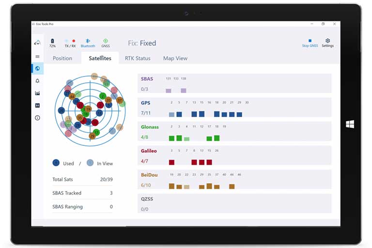
    There’s good news for operators who might have been scared away from using drones manufactured by Chinese company DJI. Two “government” models have now been cleared by the Pentagon for use by agencies who had previously been instructed to cease and desist operating them. The Matrice 600 Pro and the Mavic Pro government models were cleared, because “no malicious code or intent” was found. These types of drone are now “recommended for use by government entities and forces working with U.S. services.”

    DJI Matrice 600 Pro (Photo: DJI)
    DJI Matrice 600 Pro (Photo: DJI)

    The drones have been modified from standard models to provide a customized control application, prevent automatic software updates being applied without user approval, and implement an operational control-zone capability.

    The U.S. Interior Department was behind the modifications, with the objective of resuming use of its grounded fleet of more than 500 DJI drones. They may need them again soon for forest-fire monitoring — it’s the season again. Allegations of potential “sharing of data” with the Chinese government were previously investigated and apparently debunked by Booz Allen Hamilton, in a report released in June 2020. Now the Pentagon seems to affirm these earlier findings.

    Nevertheless, DJI remains on the Commerce Department’s don’t-buy list, and the Justice Department has banned agencies from buying foreign drones that could be vulnerable to tampering with data, or otherwise might be a threat to the U.S.

    DHS trials anti-drone system

    In recent “bad-drone” incidents, people have tried to smuggle contraband into prisons, flown into landing flight paths at airports, and even successfully inflicted significant damage on oil storage facilities in Saudi Arabia — never mind a failed assassination attempt in Venezuela. And with illegal immigration and drug smuggling becoming crisis issues, DHS has decided that its probably time to build a level of protection at U.S. borders. A trial is now scheduled at the quieter and more orderly Canadian border so that DHS can fully focus on evaluating the Fortem SkyDome system.

    TrueView Radar (Photo: Fortem Technologies)
    TrueView radar detects and calculates the location and trajectory of hundreds of airborne objects quickly and accurately. (Photo: Fortem Technologies)

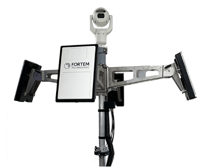
    Bad actors attacking a facility using a drone, sometimes with explosives strapped to it, have set their target as a waypoint and switched off the radio control link. The drone then carries on to its target, without fear of radio “sniffer” detection systems picking it up and jamming the control link.

    Fortem built a drone defense system that uses radar for “RF silent drone” detection. Not only does the Fortem SkyDome system detect unwanted intruder drones, but it also can send out a DroneHunter UAV which hones in on and fires a net to capture, immobilize and bring back the offending drone so the defenders can investigate the attack.

    Boeing UAV refuels F-18 fighter aircraft

    Boeing is engaged in development of an unmanned tanker vehicle for the U.S. Navy. The company has built and flown the first test drone, known as Stingray MQ-25 T1. Boeing has another seven unmanned refueling tankers on order. T1 is the first test article for the program. Following a number of successful initial handling, control and envelope extension test flights — including several with the Navy refueling pod installed under the T1 left wing — fuel was loaded, and on June 4, a Navy F/A-18 Super Hornet fighter aircraft accompanied the T1 into the air on another test flight.

    T1 Stingray refuels a Navy F/A-18. (Photo: U.S. Navy/Boeing)
    T1 Stingray refuels a Navy F/A-18. (Photo:
    U.S. Navy/Boeing)

    The F/A-18 flew close to and maneuvered around the drone for some time, and when the pilot and test managers concluded that both were in joint, controlled, stable flight, the MQ-25 was commanded to extend the refueling pod hose and drogue. The F/A-18 normally refuels in the air from another F/A-18 configured with the same refueling pod and refueling boom, so the actual transfer of fuel which then took place was somewhat commonplace for the F-18 pilot, save that the slipstream buffet was probably less significant. Nevertheless, this was the very first time that a Navy aircraft has been refueled by an unmanned aircraft.

    After further MQ-25 T1 test flights, the tanker-drone will be transported to Norfolk, Virginia, for deck handling trials aboard a U.S. Navy carrier later in the year. The MQ-25 Stingray is planned to take over this airborne refueling work which is currently handled by other F/A-18s, freeing up the fighter aircraft for operational fighter missions.

    Mars drone flight experiences navigation anomaly

    On May 25, the Mars drone Integrity had been commanded to take its sixth longer, higher flight. Like a good little tech package on the end of a 220-million-mile distant signal, Integrity did as it was told. However, after around 490 feet in the Mars atmosphere, Integrity started to change speed and dramatically oscillate back and forth. Even so, the UAV managed to complete the transit to within about 16 feet of the new intended parking spot.

    NASA analyzed the data sent back from the drone through the Perseverance rover. NASA discovered that the flow of images from the navigation camera had been disrupted by a missing image, and the time-stamps for the images had become incorrect.

    Integrity sits safely on Mars following an in-flight anomaly. (Photo: NASA)
    Integrity sits safely on Mars following an in-flight anomaly. (Photo: NASA)

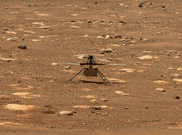
    Integrity’s navigation system is fed by an inertial measurement unit with images from the nav camera, so the time-stamp discrepancies between what the camera was saying and what the IMU was saying gave it an unforeseen issue to resolve. The resultant bucking in flight was an effort to resolve the data time differences. Images are not used in the landing phase, so the oscillations ceased as the rover descended, and the landing was as graceful as usual.

    Fortunately, it appears that Integrity has not been damaged, and NASA is working to send the little drone on further scouting missions for its companion rover. NASA’s website indicates that the drone should have flown again on June 6, but right now there doesn’t seem to be any further evidence that a flight did or did not take place.

    Summary

    The testing that the Pentagon has done on a couple of models of DJI drones appears to have cleared them of possible malfeasance, but otherwise the report is classified. I wonder what secret science DOD used to detect/eliminate possible illicit communications with China by the drones? And it’s high time everyone realized that these “drone -thingies” can also be used to hurt us — as new technology in the hands of people who do not wish us well almost always can.

    This month I discovered that Navy F/A-18s could fly further by hanging refueling pods on other F/A-18s, thereby taking the tanking aircraft out of the regular training and combat rotation. I’m glad we’ve got a drone alternative coming that must cost a lot less and also will free up fighting assets.

    Finally, it doesn’t seem that we have to worry the Mars helicopter is too broken to keep seeking the best route for the rover. There were enough margins in the navigation algorithms that the little guy didn’t wreck when the image processing hiccupped. Let’s get flying again, NASA!

    Tony Murfin
    GNSS Aerospace

  • Launchpad: Drone parachute, GNSS modules, antennas

    Launchpad: Drone parachute, GNSS modules, antennas

    A roundup of recent products in the GNSS and inertial positioning industry from the October 2020 issue of GPS World magazine.


    OEM

    GNSS antennas

    Active and passive

    Photo: 2J Antennas
    Photo: 2J Antennas

    A new range of high-precision GNSS antennas is designed for superior accuracy and reliability, with both active external antennas and passive internal ceramic antennas. The antennas provide precision, high bandwidth, and an advanced signal design for GPS, GLONASS, BeiDou, Galileo, IRNSS and SBAS navigation. They are designed for demanding GPS applications that require centimeter-level accuracy by combining precise point positioning (PPP) of L1 and L2 or by combining L1 and L5 bands with real-time kinematic (RTK) satellite navigation. Applications include aviation safety, UAVs, transportation, autonomous vehicles, agriculture and land and hydrographic surveys.

    2J Antennas, 2j-antennas.com

    Helical Antenna

    For high-accuracy positioning

    HC976 triple-band helical antenna with L-band, embedded version. (Photo: Tallysman)
    Photo: Tallysman

    The HC976 housed and HC976E embedded helical antennas are light and compact, suitable for applications ranging from autonomous navigation to GNSS timing. Both models support GPS/QZSS-L1/L2/L6, GLONASS-G1/G2, Galileo-E1/E6, and BeiDou-B1/B3 frequency bands as well as regional augmentation systems and high-precision L-band correction services. The HC976 and HC976E support QZSS-L6, Galileo-E6 and BeiDou-B3. The HC976 is 44 x 62 millimeters and weighs 42 grams. It features a precision-tuned helical element that provides an excellent axial ratio and operates without the requirement of a ground plane, making it suitable for a wide variety of high-precision applications.

    Tallysman, tallysman.com

    Timing module

    With nanosecond-level accuracy

    Photo: Septentrio
    Photo: Septentrio

    The mosaic-T GPS/GNSS receiver module is built for resilient and precise time and frequency synchronization under challenging conditions. Its multi-frequency, multi-constellation GNSS technology with AIM+ Advanced Interference Mitigation algorithms allows mosaic-T to achieve maximal availability even in the presence of GNSS jamming or spoofing. The compact surface-mount module is designed for automated assembly and high-volume production. Mosaic-T delivers timing and has additional inputs for an external high-accuracy clock.

    Septentrio, septentrio.com

    Inertial system

    For autonomous vehicles, surveying

    Photo: Honeywell
    Photo: Honeywell

    The HGuide n380 inertial navigation system (INS) communicates an object’s position, orientation and velocity when GNSS signals are unavailable. It is built to withstand harsh environments in the air, on land or at sea. It is designed to meet the need for a small, high-performance INS for 3D mapping, surveying and other applications where space is at a premium. It is composed of Honeywell’s HGuide i300 inertial measurement unit (IMU), a GNSS receiver and Honeywell’s proprietary sensor-fusion software, which is based on the algorithms used for navigation on millions of aircraft every day.

    Honeywell, honeywell.com

    Mobility module

    Integrates dead reckoning, RTK

    Photo: Quectel
    Photo: Quectel

    The LC29D eMobility module is a sub-meter-level GNSS module that integrates dead-reckoning and multi-band (L1/L5) real-time kinematic (RTK) algorithm technologies with fast convergence times and reliable performance. The module supports dual-band GNSS raw data output and integrates a 6-axis IMU sensor to deliver high-accuracy positioning performance in seconds. Based on the Broadcom BCM47758 GNSS chip, the LC29D can concurrently receive signals from up to six constellations (GPS, GLONASS, Galileo, IRNSS, BeiDou and QZSS), which maximizes the availability of sub-meter level accuracy. It offers a position update rate of up to 30 Hz (fusion output), enabling dynamic applications like shared emobility, delivery robots and precision agriculture to receive position information with lower latency.

    Quectel Wireless Solutions, quectel.com


    SURVEYING & MAPPING

    Lidar series

    Collects 3D and geospatial data

    Photo: CHCNAV
    Photo: CHCNAV

    The AlphaUni 300/900/1300 lidar series provides light, versatile long-range laser scanner systems for the high-end market. The series provides optimized data sets powered by advanced GNSS/inertial navigation system (INS) sensors and long-range Riegl scanners. AlphaUni’s design adapts to a variety of applications and can be installed on a variety of platforms, including multi-rotor UAV, fixed-wing vertical-takeoff-and-landing (VTOL) UAV, vehicles, rail trolleys, backpacks, boats and more.

    CHC Navigation, www.chcnav.com

    GNSS receiver

    With multi-touch screen

    Photo: Geneq
    Photo: Geneq

    The F100 GNSS receiver, an upgrade to the F90, is designed to meet surveyors’ demands for high field performance, flexibility and cost-effectiveness. It tracks multiple constellations (GPS, GLONASS, Galileo, BeiDou) and can maximize the acquisition and tracking process with all-in-view GNSS frequencies. The 1.45-inch color LCD display is a multi-touch capacitive screen. The F100 has 32GB of internal memory. Its integrated second-generation web user interface control is compatible with all devices and browsers.

    Geneq, www.geneq.com

    Windows software

    Uses all four constellations

    Eos Tools Pro for Windows shows all current satellites in use from GNSS constellations such as GPS, Galileo, BeiDou, GLONASS and QZSS. (Screenshot: Eos Positioning)
    Screenshot: Eos Positioning

    Eos Tools Pro for Windows 10 implements powerful new features that enable users to exploit all four global GNSS constellations and a state-of-the-art NTRIP client to access real-time kinematic (RTK) bases and RTK networks all over the world via NTRIP, Direct IP and wireless radios. It provides the latest support for Windows Geolocation and other features by Microsoft to allow customers to use high-accuracy locations directly in their apps, such as RTK network/RTK base connectivity, support for all new Beidou and Galileo satellites, and SafeRTK functionality for areas with marginal cellular coverage. Features for app developers are also available.

    Eos Positioning Systems, eos-gnss.com
    Microsoft, microsoft.com


    UAV

    Multi-rotor drone

    Optimized for lidar

    Photo: CHCNAV
    Photo: CHCNAV

    The BB4 UAV high-end multi-rotor drone is optimized for the AlphaUni 300/900/1300 lidar series. Its modular design simplifies deployment in just a few minutes. Its 7-kg payload breaks the capacity barrier, and its more than 45 minutes of flight time increases the airborne lidar survey ability. The redundant CHCNAV and DJI inertial measurement unit (IMU) and GNSS unit provide reliable centimeter real-time kinematic (RTK) positioning, meeting the demand for high accuracy in the geospatial and mapping industries.

    CHC Navigation, www.chcnav.com

    Medical delivery system

    Speeds receipt of essential supplies

    Photo: Antwork Robotics
    Photo: Antwork Robotics

    The ADNET autonomous delivery network is a technical solution to transport medical samples and quarantine materials in cities. It uses an RA3 drone, unmanned vehicle RG1 and RH1 hub station to deliver medical supplies without relying on manpower, alleviating time spent in traffic and the cost of traditional delivery. Supplies retrieved by the RG1 vehicle are delivered to the RH1 hub for sorting and redirecting, while the drone transfers the supplies between hubs. The RG1 then delivers goods on the receiving end. The system was demonstrated during China’s COVID-19 epidemic prevention and control period, reducing contact between samples and personnel.

    Terra Drone, terra-drone.net
    Antwork Robotics, antwork.link

    Autopilot

    For manufacturers of aerial targets

    Photo: UAV Navigation
    Photo:

    The VECTOR-400 is a compact autopilot designed specifically for unmanned aerial vehicles. It features a robust enclosure and a military-grade connector for harsh environments (MIL-STD 810 and MIL-STD 461). Features enable sea-skimming (extremely low-level flight) and the capability to navigate without GNSS. The VECTOR-400 is able to continue a mission in case of individual sensor failure and when subject to jamming, maintaining accurate estimations of attitude and position. Advanced algorithms provide stall prevention and the ability to carry out an efficient gliding maneuver in case of engine failure. Its air data attitude and heading reference system and inertial navigation system provide high-precision attitude information and reliable navigation under demanding circumstances.

    UAV Navigation, uavnavigation.com

    Interceptor drone

    Deters careless and criminal drones

    Photo: Fortem Technologies
    Photo: Fortem Technologies

    The F700 DroneHunter UAS is a radar-based autonomous interceptor drone for tracking and stopping dangerous drones. Its flexible undercarriage offers interchangeable counter measures for single, multiple or swarm-based threats, while its lightweight carbon-fiber frame enables quick speed and response. The F700 can carry multiple types of anti-drone countermeasures and deploy them in real time, based on which dynamic threat is detected miles beyond the protected area. The pogo pins and payload snaps of the undercarriage are integrated with artificial intelligence for firing and flight software.

    Fortem Technologies, fortemtech.com

    Parachute system

    Protects investment in drone, sensors

    Photo: Drone Rescue Systems
    Photo: Drone Rescue Systems

    Drones equipped with cost-intensive cameras and sensors need protection in the event of a flight-system failure. A parachute system for the DJI M210 drone is now available. Both commercial and emergency response operations are using the M210; its design and flexibility allow for a variety of industry-specific applications. The DRS-M210 parachute system is designed to ensure high pendulum and wind stability, allowing a damaged drone to land safely with minimal impact.

    Drone Rescue Systems, dronerescue.com


    TRANSPORTATION

    Aircraft panel display

    Altitude indicator (AI) or directional gyro (DG) replacement

    Photo: uAvionix
    Photo: uAvionix

    The AV-30-C aircraft panel display adds a suite of in-flight information for pilots, including GPS navigational data, a probeless angle of attack indicator, baro-corrected altitude, indicated/vertical/true airspeed, non-slaved heading, bus voltage and G load. It is designed to fit into any aircraft with a 3 1/8-inch round instrument slot without cutting or modifying the panel. It is authorized for FAR Part 23 Class 1 and Class 2 aircraft listed on the AV-30-C Approved Model List (AML), containing 635 aircraft models including Cessna, Piper, Beechcraft, American Champion, Maule, Boeing, Swift, Mooney, Aviat and others.

    UAvionix, uavionix.com

    Computer with GNSS

    Certified for rolling rail stock

    Photo: Lanner
    Photo: Lanner

    The R3S series of rugged, EN-50155-certified fanless vehicle/rail computers is equipped with a u-blox NEO-M8N module, which receives GPS, Galileo, GLONASS and BeiDou with the default set for GPS + GLONASS dual band. The series offers power-efficient performance for consolidating in-vehicle workloads such as video surveillance, control/monitoring, passenger information and Wi-Fi hotspot sharing. For edge-to-cloud connectivity, R3S uses its internal GPS/GLONASS chipsets for GPS tracking and has two M.2 slots with up to 4x SIM card readers for failover LTE connection. To ensure proper operations in moving vehicles, the series is certified with EN50155, EN50121-3-2, EN50121-4, EN50125-3, EN45545 and E13 standards and has passed MIL-STD-810G shock and vibration resistance certifications. The series can operate under a wide temperature range and offers excellent reliability in harsh railway settings. It has one external removable 2.5-inch HDD/SSD drive bay for recorded footage storage. For consolidating in-vehicle workloads such as in-vehicle control/monitoring and passenger information, the R3S features a variety of I/O support, including 2x HDMI, DI/DO, 3x COM/CAN BUS and 4xUSB ports.

    Lanner Electronics, lannerinc.com
    u-blox, ublox.com

  • Fortem Technologies enables safe drone delivery of medical supplies in North Carolina

    Fortem Technologies enables safe drone delivery of medical supplies in North Carolina

    Photo: Fortem Technologies
    Photo: Fortem Technologies

    Fortem Technologies has completed the first phase of the U.S. Department of Transportation’s Unmanned Aircraft Systems Integration Pilot Program (UAS IPP) in North Carolina.

    As part of the program, Fortem is conducting tests to monitor the airspace around WakeMed Hospital in Raleigh, tracking manned flights alongside the UPS Delivery Corridor, and delivering medical test samples via unmanned drones. Fortem has been using its TrueView radar and SkyDome software system to ensure UAS operations and drone deliveries do not interfere with medical helicopters flying in and out of the area, as well as alert drone operators of any potential non-cooperative aircraft in the vicinity.

    According to the company, it was able to accurately and consistently track incoming medical helicopter traffic, providing real-time alerts to Airmap, an unmanned service supplier.

    “By monitoring the airspace and creating a service that ensures the safe use of unmanned air vehicles, we will expand from these initial drone deliveries to greater geographical reach and more sophisticated roles for unmanned drones,” said Adam Robertson, CTO of Fortem Technologies. “With Fortem’s ability to offer real time data and analysis of airborne threats, we can start to see additional support for things like search and rescue operations, first responders, and increased shipments of critical supplies to remote locations. None of this can happen without the trust that our systems are effective and safe.”

    The North Carolina Department of Transportation (NCDOT) Division of Aviation partners, including WakeMed Hospital, are testing drone operations that will soon go beyond a pilot’s visual line of sight to provide efficient and safe drone operations with the ultimate goal of helping to improve healthcare access for all North Carolinians.

    “Ensuring the safety of manned aviation is paramount for unmanned flight operations, yet successful coordination of the two is not an easy task,” said Basil Yap, UAS program manager at NCDOT. “The phase one testing has shown promising results and we are hopeful the phase two operations will provide the information we need to receive a beyond-visual-line-of-sight waiver from the Federal Aviation Administration.”

    Fortem will continue to provide situational awareness and secure the airspace into the next phase of the program, the company said. NCDOT, as part of the USDOT UAS IPP, will continue to support its partners’ operations at WakeMed throughout the year until the program’s conclusion in October.

  • Fortem Technologies ships DroneHunter F700 C-AUS

    Fortem Technologies ships DroneHunter F700 C-AUS

    DroneHunter F700. (Photo: Fortem Technologies)
    DroneHunter F700. (Photo: Fortem Technologies)

    DroneHunter F700 is a radar-based autonomous interceptor drone for tracking and stopping dangerous drones

    Fortem Technologies Inc. is now shipping its artificial intelligence (AI)-enabled F700 DroneHunter. The F700 is a safe, effective deterrent against a rising number of careless and criminal drones, the company said.

    The F700 has a flexible undercarriage that offers interchangeable counter measures for single, multiple or swarm-based threats. Its new lightweight carbon-fiber frame enables greater athleticism and speed.

    The F700 can carry multiple types of anti-drone countermeasures and deploy them in real-time, based on the dynamic threat detected miles beyond the protected area. The undercarriage features pogo pins and payload snaps integrated with AI-enabled firing and flight software.

    Underside of the DroneHunter F700. (Photo: Fortem Technologies)Photo:
    Underside of the DroneHunter F700. (Photo: Fortem Technologies)Photo:

    The F700 offers significant payload capacity to handle situations over civilians where zero collateral damage is required. AI decisions are now made in real-time to select the appropriate effectors for the detected threat. Complex algorithms for flying in urban areas are now supported. Heavier drones are tethered or parachuted with controlled descent into predetermined safe zones.

    The F700 is equipped with ground- and airborne-networked radar and corresponding optics, giving users total situational awareness and autonomous precision. F700 is custom designed and manufactured in the United States.

    “We have advanced the DroneHunter F700 so that it can deliver any ordinance necessary to stop drones and to protect stadiums, refineries, campuses and entire metro regions,” said Fortem Technologies CEO, Timothy Bean.

    Fortem is developing several DroneHunter mitigation types, including directed energy.

  • Fortem’s detect-and-avoid system brings BVLOS to UAV pilot program

    Fortem Technologies‘ new TrueView technology is being used in the U.S. Unmanned Aircraft Systems Integration Pilot Program to detect potential air-to-air collisions and enable unmanned aircraft to safely navigate beyond visual line of sight (BVLOS) day or night and in clouds, fog, smog and other challenging weather conditions.

    The TrueView R20.

    Fortem Technologies is working with Lead Pilot Partners to further the pilot program. The program aims to accelerate safe integration of UAS into the national airspace.

    Fortem’s TrueView R20 meets critical selection criteria by putting safety and security data at the forefront to enable expanded drone operations such as BVLOS and operations at night. Using AI algorithms, TrueView provides accurate real-time situational intelligence and awareness for safe, autonomous, unmanned aircraft operations.

    Fortem TrueView R20 weighs 1.5 lbs. and is a breakthrough technology because of its small form factor, weight, power requirements and low cost.

    Fortem’s radar technology has been hardened over the past six years through rigorous testing with the U.S. Department of Defense.The company provides advanced radar systems and associated software systems for manned and unmanned aircraft as well as its own modern air defense system known as the Fortem DroneHunter.

    In January, Fortem Technologies announced the close of a $5.5 million funding round led by Signia Venture Partners and Data Collective.

    “One of the biggest challenges for the UAS industry is the ability to detect other aircraft and stay well clear from potential collisions,” said Jared Essleman, director, Utah division of aeronautics. “Achieving safe autonomous flight beyond-visual-line-of sight is going to be the next big chapter for the aviation industry. The announcement of TrueView R20 technology is an exciting development for safe autonomous operations, allowing UAS to course correct as needed to mitigate risk.”

    “We are proud of our progress and ability to innovate around one of the most daunting challenges in the drone industry; namely safe BVLOS and nighttime operations,” saidTimothy Bean, CEO of Fortem Technologies. “With TrueView, we have responded to feedback from our customers to bring this needed detect-and-avoid product to a worldwide market.”

  • IMSAR sells UAV detect-and-avoid radar tech to Fortem

    IMSAR LLC, manufacturer of miniaturized synthetic aperture radar (SAR), is selling its detect and avoid radar technology to Fortem Technologies. The technology powered IMSAR’s previously announced family of collision-avoidance radar designed for the commercial unmanned aerial systems (UAS) market.

    The Federal Aviation Administration (FAA) requires an aircraft operating in civil airspace to be able to “see and avoid” other aircraft. Collision-avoidance systems seek to meet this requirement by allowing UASs to detect other airborne objects, predict potential midair collisions, and automatically maneuver the UAS to avoid catastrophes.

    A radar-based sense-and-avoid solution for small UAS was previously not viable because of high cost, weight and complex technology and algorithms required. Fortem’s product will enable small UAS to avoid mid-air collisions with manned or unmanned aircraft as well as targets that lack a transponder, such as cranes, paving the way for the integration of UAS into civil airspace worldwide.

    “Radar is ideally suited because it operates effectively in darkness, cloud cover, fog, smoke and precipitation,” said Britton Quist, IMSAR’s CTO.

    According to Ryan Smith, CEO, IMSAR, key development milestones have been met allowing the spin out of sense and avoid to Fortem Technologies. Adam Robertson, vice president of IMSAR, will be leaving to join Fortem Technologies after nine years at IMSAR.

    Fortem Technologies has announced product availability in July 2016.

    Fortem and IMSAR products are on display May 2-5 at the AUVSI Xponential show in New Orleans, Booth 134.