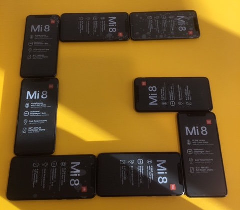
Xiaomi Mi 8 dual-frequency smartphones procured for teams participating in ESA’s second Galileo App Competition, taking place at ESTEC in the Netherlands on April 18. (Photo: ESA)
The final presentations of ESA’s second Galileo smartphone app competition will take place April 18. The public is invited to watch the awards ceremony via livestream.
The competition’s goal is to develop an app capable of performing fixes using raw Galileo satnav measurements. Members of the public can also vote for their favorite app.
Five teams are competing this year. The competition is run by the European Space Agency (ESA)
in collaboration with the European Global Navigation Satellite Systems Agency (GSA) plus the European Commission with the support of Google. It was open to all students from European universities and trainees in posts at European research and development organisations.
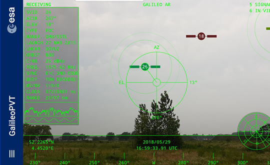
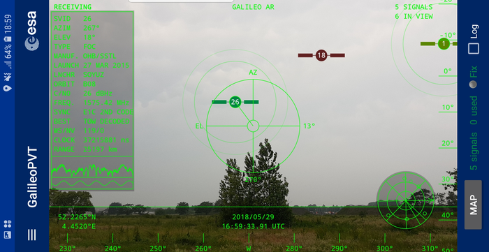
The European Space Agency (ESA) has released an augmented reality view of Galileo satellites in the sky close to its technical centre in the Netherlands.
The image comes from a Galileo-focused satnav app for Android smartphones, developed by ESA engineers. ESA ran an internal competition for its trainees to develop an app capable of making positioning fixes using only Galileo satellites.
“As part of our support for the competition, we developed our own app on a voluntary basis to serve as a benchmark,” said Paolo Crosta of ESA’s Radio Navigation Systems and Technology section. “We included this augmented reality view, so users can ‘see’ the satellites their smartphone is using as they hold it up to the sky.”
Galileo satellites viewed in smartphone app. (Photos: ESA)
The positioning calculations and assistance data functions for the app were developed by Paolo, with telecom engineer Tim Watterton contributing the main structure of the app, together with how it looks and its user interface.
“The satellites are overlaid in real time on the camera view in their predicted positions in the sky, based on ‘ephemeris’ information, assistance data that describes the current satellite orbits with high precision,” Watterton said. “When a signal is being received, the satellite is shown in green, overlaying the predicted position. The satellite shown in red is one of the two placed in elongated orbits, but these satellites are expected to be used soon in the operational constellation. Satellites colored orange are transmitting, but the signal is not detected, which may be due to obstruction by terrain or buildings.”
Panning the phone around to position the crosshair over a green-colored satellite adds additional information, such as its signal status, pseudorange (the uncorrected distance the signal has traveled to reach the receiver) plus the satellite’s manufacturer and launch date, among other items.
The reference app is now being tested with the hope of making it publicly available on the Google Play Store. Following the competition, the trainees are also testing their own apps with the goal of releasing them.