Tag: Galileo services

  • Galileo declares: Open for business!

    Galileo declares: Open for business!

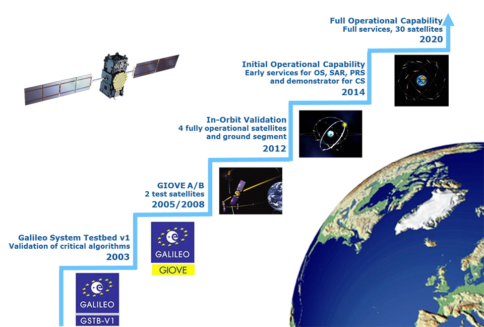
    At a Dec. 15 ceremony in Brussels titled “Galileo Goes Live,” two high officials of the European Commission issued the Galileo Initial Services Declaration.

    The declaration means that the Galileo satellites and ground infrastructure are now operationally ready. These signals will be highly accurate but not available all the time, since the constellation is not yet complete and users cannot always count on four satellites being visible at one time at all points on the Earth.

    Galileo Goes Live! ceremony in Brussels: European Commission Vice-President Maroš Šefčovič, responsible for the Energy Union, and Commissioner Elżbieta Bieńkowska, responsible for Internal Market, Industry, Entrepreneurship and SMEs, count down to hit the “Go” button.
    Galileo Goes Live! ceremony in Brussels: European Commission Vice-President Maroš Šefčovič, responsible for the Energy Union, and Commissioner Elżbieta Bieńkowska, responsible for Internal Market, Industry, Entrepreneurship and SMEs, count down to hit the “Go” button. Photo: Galileo

    Simultaneously, the European GNSS Agency (GSA) awarded the Galileo Service Operator (GSOp) contract, with a value of up to 1.5 billion euros, to Spaceopal, a joint venture between Telespazio and the German Space Agency (DLR).

    The Galileo constellation currently consists of 18 satellites in orbit. However, two of these are in an orbit not totally useful for positioning and navigation. Four more, launched in November, may or may not have completed their on-orbit testing (a series of notice advisory to Galileo users or NAGUs has appeared relating to the flag status of each satellite; see details at the end of this story) but have not yet been integrated to the operational constellation. This is expected to take place in spring 2017.

    During the initial phase, the first Galileo signals will be used in combination with other satellite navigation systems, like GPS. In coming years, new satellites will be launched to enlarge the constellation, gradually improving Galileo availability worldwide. The constellation is expected to be complete by 2020 when Galileo will reach full operational capacity (FOC) of 30 satellites: 24 satellites plus six orbital spares, intended to prevent any interruption in service.

    Paul Verhoef, the European Space Agency’s (ESA’s) director of the Galileo Programme and Navigation-related Activities, stated, “Today’s announcement marks the transition from a test system to one that is operational. Still, much work remains to be done. The entire constellation needs to be deployed, the ground infrastructure needs to be completed, and the overall system needs to be tested and verified.

    “In addition, together with the commission we have started work on the second generation, and this is likely to be a long but rewarding adventure.”

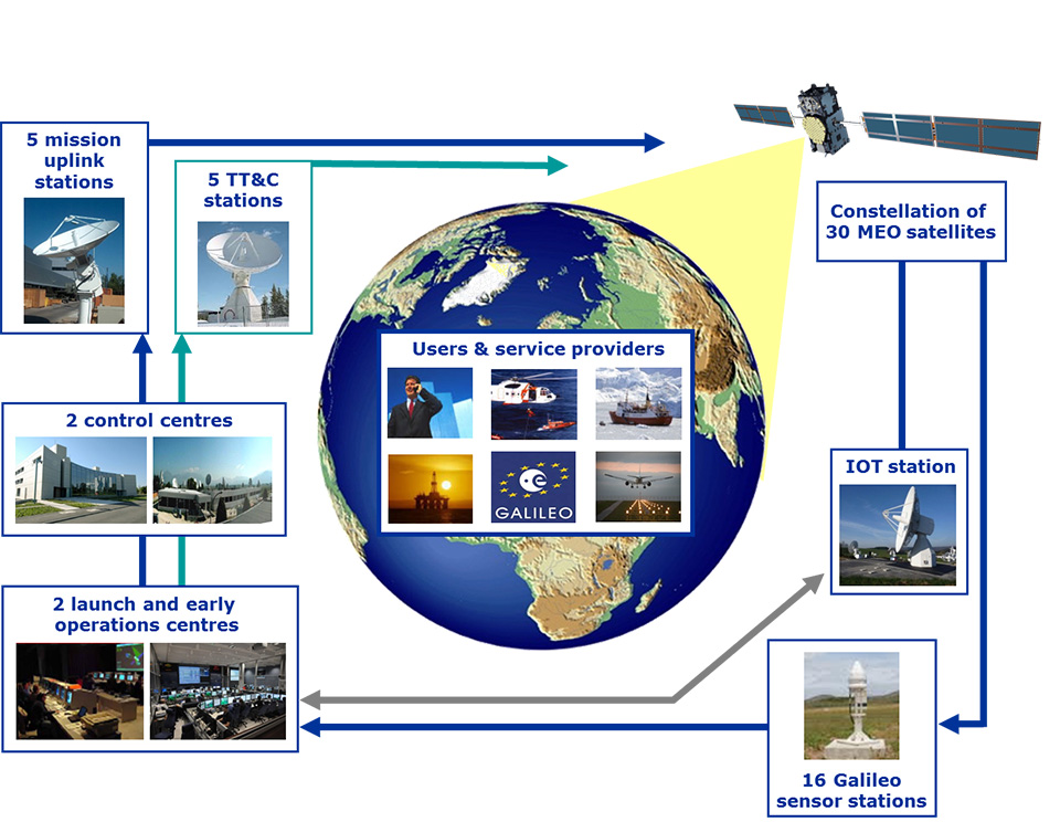
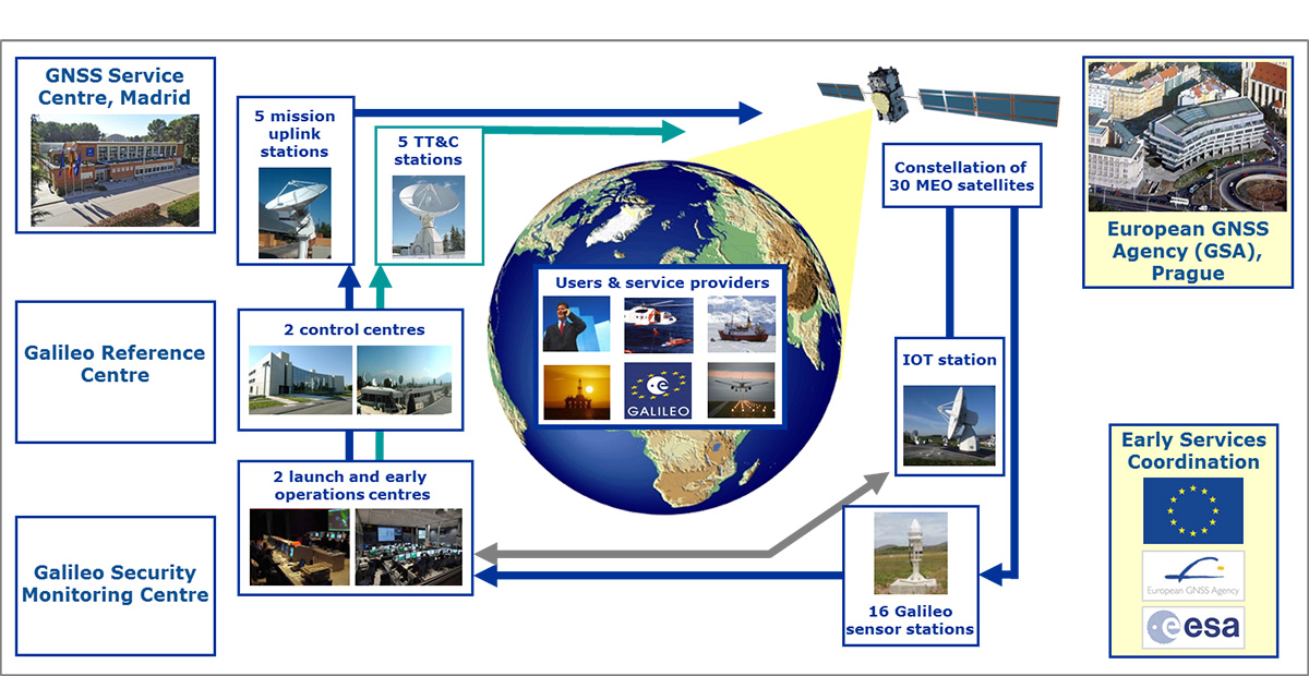
    Galileo Initial Services are managed by the GSA. The overall Galileo programme is run by the European Commission, which has handed over responsibility for the deployment of the system and technical support to operational tasks to the ESA.

    Operator Contract. The GSOp contract runs for 10 years and covers operation and maintenance of the Galileo satellite system and its committed performance level: in particular, the operations and control of the system, the logistics and maintenance of the systems, and infrastructure as well as the user support services.

    “With its emphasis on service performance, this contract will shape the future of Galileo. We look forward to building a strong partnership with Spaceopal as Galileo moves towards full operational capability under the responsibility of the GSA from January 2017,” said GSA Executive Director Carlo des Dorides.

    Under GSA management, the contract awarded to Spaceopal specifically includes:

    • Secure operations of Galileo from two mission control centres (GCC), located in Germany and Italy, and the European GNSS Service Centre (GSC) for user support services in Spain;
    • Management of the Galileo Data Distribution Network (GDDN);
    • Integrated logistics support and maintenance for the entire space and ground infrastructure;
    • Monitoring of the system performance;
    • Support for the completion of the Galileo infrastructure and associated launches.

    Spaceopal has served as the contractor for Galileo operations since 2010 under the Galileo Full Operational Capability (FOC) Operations Framework Contract.

    Products and Services. The first Galileo smartphone by Spanish company BQ is now available on the market, and other manufacturers are expected to follow suit. Application developers can now test their ideas on the basis of a real signal.

    With the declaration, Galileo will start to deliver, in conjunction with GPS, the following three types of services free of charge. Their availability will improve as more satellites are launched.

    The Open Service is a free mass-market service for users with enabled chipsets in, for instance, smartphones and car navigation systems. Fully interoperable with GPS, combined coverage will deliver more accurate and reliable positioning for users.

    Public Regulated Service is an encrypted, robust service for government-authorized users such as civil protection, fire brigades and the police.

    Search and Rescue Service is Europe’s contribution to the long-running Cospas–Sarsat international emergency beacon location. The time between someone locating a distress beacon when lost at sea or in the wilderness will be reduced from up to three hours to just 10 minutes, with its location determined to within 5 kilometers, rather than the previous 10 kilometers.

    Advisory Updates. USABINIT NAGUs were issued for 11 satellites: 0101, 0102, 0103, 0203, 0204, 0205, 0206, 0208, 0209, 0210 and 0211.

    USABINIT, or Initially Usable, notifies users that a satellite is set healthy for the first time. 0104 had a power problem and is operating on E1 only. 0201 and 0202 were launched into lower orbits.

    0207 and 0212–0214 are still undergoing commissioning and drifting to their designated orbital slots.


    Ground control upgrade for GPS III approved

    The U.S. Air Force approved Lockheed Martin’s design to upgrade the current GPS satellite ground control system with new capabilities that will enable it to operate more powerful and accurate GPS III satellites.

    The successful Critical Design Review (CDR) for the Contingency Operations (COps) contract, completed on Nov. 17, gives Lockheed Martin a green light to proceed with software development and systems engineering to modify the existing GPS ground control system, called the Architecture Evolution Plan (AEP) Operational Control Segment.

    The AEP is currently maintained by Lockheed Martin and controls the 31 GPS IIR, IIR-M and IIF satellites in orbit today.

    The COps modifications will allow the AEP to support the more powerful, next-generation GPS Block III satellites, enabling them to perform their positioning, navigation and timing mission, once they are launched. COps is envisioned as a temporary gap filler prior to the entire GPS constellation’s transition to operations onto the next generation Operational Control System (OCX) Block 1, currently in development.

    On Oct. 15, under a separate contract, Lockheed Martin completed the Commercial Off-the-Shelf (COTS) Upgrade #2 (CUP2) project — part of a multi-year plan to refresh the AEP’s technology and enhance the system’s ability to protect data and infrastructure from internal and external cyber threats, as well as improve its overall sustainability and operability. CUP2 is now fully operational and managing the current GPS constellation.

    Lockheed Martin also is under contract to develop and build the Air Force’s first 10 GPS III satellites, which will deliver three times better accuracy, provide up to eight times improved anti-jamming capabilities, and extend spacecraft life to 15 years, 25 percent longer than the newest GPS satellites on-orbit today.

    GPS III’s new L1C civil signal will make it the first GPS satellite to be interoperable with other international global navigation satellite systems.


    GPS funded at $847 million for FY 2017

    On Dec. 23, 2016, President Obama signed the National Defense Authorization Act (NDAA) for Fiscal Year 2017. The act includes policy and funding guidance for the GPS program of $847.362 million. This total excludes $13.171 million requested for the GPS IIF program, which requires FY 2017 funding for on-orbit support and contract closeout.

    Procurement of GPS III satellites is budgeted at $34 million, development of GPS III satellites is at almost $142 million and the next-generation ground control system (OCX) is budgeted at $393 million, which comes with certification and congressional briefing requirements. The amount includes funding for the GPS Enterprise Integrator.

    The GPS Enterprise Integrator project includes efforts necessary to accomplish the critical integrating function with the entire GPS user community. The Enterprise Integrator maintains the GPS architecture and system definition, controls and validates interfaces, ensures compatibility of Generation II and III systems, and develops and manages plans for execution and fielding of the GPS enterprise.

    The final defense budget item is $278 million for development of new military GPS user equipment.

    Besides the NDAA, other areas that include funding for GPS and related programs are Transportation (including WAAS), to support designated civil elements of the Air Force GPS program, along with civil GPS augmentations and related activities.

    The Department of Transportation this year requested civil funding for GPS through the Office of the Secretary instead of through the FAA. Also, the request does not include funds for the Nationwide Differential GPS (NDGPS) program in FY 2017.

  • Directions 2015: Galileo Looks Ahead to Early Services

    GPS-directions-GalileoThe European GNSS Agency (GSA) hosted the ninth meeting of the International Committee on Global Navigation Satellite Systems (ICG) in November at its headquarters in Prague, Czech Republic. The event is an opportunity for GNSS providers to present the status and future plans for their systems, and an opportunity for ICG members, associate members, and observers to provide updates on recent developments with regard to GNSS services and applications.

    Representatives from the world’s leading global and regional GNSS programs were invited to provide the assembly with a “state of play” for their respective systems. Joining GPS, GLONASS, BeiDou, IRNSS/GAGAN, and QZSS was Galileo, represented by Christian Siebert, Head of Unit, Galileo and EGNOS: Applications, Security and International Cooperation, DG Enterprise and Industry, European Commission.

    A Secure Foundation

    The key message coming from Prague was that, despite the launch anomaly in August, the Galileo program has a secure foundation for moving forward. For instance, it has been given a stable seven-year perspective, a substantial budget, and a new exploitation-driven governance scheme. In terms of budget, the European Commission has allocated €1.930 billion for deployment and €3 billion for exploitation — with an additional €1.580 billion allocation for European Geostationary Navigation Overlay Service (EGNOS) exploitation.

    The new governance scheme is based on a recently announced agreement between the European Commission and the GSA; the agreement delegates a range of exploitation tasks for Galileo to the GSA. Serving as an initial step towards the full Galileo Exploitation Phase, the GSA’s responsibilities now include:

    • provision and marketing of the services;
    • management, maintenance, continuous improvement, evolution and protection of the space and ground infrastructure;
    • research and development of receiver platforms with innovative features in different application domains;
    • development of future generations of the system;
    • cooperation with other GNSS;
    • all other required activities to ensure the development and smooth running of the system.

    This new budget and governance structure ensures the Galileo program’s stability for the next seven years, according to a GSA press release. The agency will progressively manage exploitation activities as delegated by the European Commission, which serves as the program’s supervisor.

    At the same time, the European Space Agency (ESA) will continue its role for system design and development.

    A Range of Successes

    “The past year has seen the program achieve a range of milestones,” said Siebert. “The Galileo In-Orbit Validation Phase was successfully concluded, the ground infrastructure deployment finalized for initial operations, and the new satellite design qualified.”

    Even with the satellite launch anomaly that left two satellites in the wrong orbit, the ESA just announced that one of these satellites will soon make a series of maneuvers as a prelude to its health being confirmed. The aim is to raise the lowest point of its orbit — its perigee — to reduce the radiation exposure from the Van Allen radiation belts surrounding Earth, as well as put it into a more useful orbit for navigation purposes. If the operation is successful, the second satellite will follow suit.

    As to the cause of the anomaly itself, Siebert said Arianespace has established an inquiry board to investigate, and the European Commission and ESA continue to analyze the best options for recovering the initial mission to the best possible extent. A new launch sequence will be confirmed in the near future.

    That being said, the deployment plan for the Galileo constellation is secured, with 26 satellites ordered (four IOV and 22 FOC) and launcher service contracts for the full constellation signed with Arianespace. As to the new satellite design, production proceeds at a good pace, with full operational capability (FOC) satellites being built by OHB Systems and navigation payloads provided by Surrey Satellite Technology Ltd.

    In terms of services, the Search and Rescue Forward Link Alert Service successfully tested the networked ground segment last April, and positioning accuracy exceeds expectations.

    As to the Commercial Services Demonstrator, the main objective of the demonstrator was to test and characterize the high accuracy and authentication performance obtainable with the Galileo Commercial Service. The first results are extremely promising, with high accuracy already demonstrated through PPP information transmitted via E6B and used to enhance both Galileo and GPS. 

    Siebert noted that the ongoing Receiver Test Campaign supports manufacturers to ensure that Galileo is well implemented in chipsets and receivers. To accomplish this, the program continues to develop dialogs with the user/receiver segment to understand the market situation and follow up adoption of Galileo.

    Looking Ahead

    With this secure foundation, looking towards 2015 and beyond, Galileo is set to deliver a reliable, high-quality service to the world, according to EC and ESA spokespersons presenting at the ICG. “With its substantial budget and exploitation-focused governance scheme, it will continue to evolve and introduce innovative features,” Siebert affirmed.

    Next steps for the program include a gradual introduction of the early phase of service delivery, which will rely heavily on interaction with users. Early services will be run with continued infrastructure deployments. The program will soon conduct a service validation campaign, along with finalizing the Commercial Service definition and developing a long-term service plan. 

    “This service plan will be aligned with the trend of most user communities moving towards service levels based on a multi-constellation approach,” concluded Siebert. “Knowing this, it is crucial to continue to improve signal compatibility and interoperability of the Galileo service with other providers and cooperate on building multi-constellation programs.”

    Group-ICG-2014
    Photo: Galileo
  • Airbus Defence & Space Wins ESNC Competition

    The Airbus team (from left): Thorsten Rudolph, Jan Wendel, Wolfgang Kogler, Rolf Densing. Photo: ESNC
    Thorsten Rudolph, Application Center GmbH Oberpfaffenhofen (left), and Rolf Densing, DLR (right), award the Airbus team of Jan Wendel and Wolfgang Kogler the EUR 20,000 grand prize. Photo: ESNC

    The winner of the European Satellite Navigation Competition (ESNC) 2014 is Airbus Defence & Space, which won over the jury of experts from around the world with its ground-breaking and cost-effective receiver for the Galileo Public Regulated Service (PRS).

    The award winners were announced October 23 at an awards ceremony held at the Berlin headquarters of Deutsche Telekom. The awards recognize innovations in the commercial use of satellite navigation technology.

    “Award winners Wolfgang Kogler and Jan Wendel from Airbus Defence & Space have taken a cutting-edge approach to designing a low-cost receiver that enables police departments, fire brigades, emergency medical services, and other public entities to make use of the Galileo PRS system,” The ESNC said. “Its core innovation involves the development of a special network architecture that combines the receiver with an assistance server. The concept accounts for all the required security aspects and significantly reduces costs and the complexity of user receivers, thus facilitating broader use of PRS in the realm of public security.”

    Airbus-bavaria-prs

    In addition to the EUR 20,000 grand prize, the design took home Bavaria’s regional prize and the ESNC’s special PRS prize, which was awarded by Germany’s Federal Ministry of Transport and Digital Infrastructure (BMVI) and Federal Ministry for Economic Affairs and Energy (BMWi).

    “This special prize reflects our effort to further examine possibilities for the use of PRS applications,” said Tobias Miethaner, Head of the BMVI’s Digital Society, in his opening address at the awards ceremony. “I am delighted to see that the ESNC is already providing an important impetus to the promotion and development of innovative applications of the future Galileo PRS in its first year.”

    Over the past decade, the ESNC has brought forth numerous new applications in the field of satellite navigation. The 2014 edition was shaped in particular by the imminent launch of the first Galileo services, with more than 40% of the 434 submissions received from more than 40 countries seeking to employ Galileo/EGNOS in their own products and services.

    “Thanks to our international network, we’re in an excellent position to take advantage of Galileo’s operational launch,” said Thorsten Rudolph, managing director of Anwendungszentrum GmbH Oberpfaffenhofen, which initiated and continues to organize the ESNC. “We believe that the ESNC’s function as a leading innovation framework in its field will grant it an equally important role in Europe’s new satellite navigation system.”

    Along with the overall winner, 240 experts in the ESNC’s renowned network selected more than 30 other winners in the competition’s regional and special-prize challenges. Under the patronage of Germany’s Federal Minister of Transport, prizes worth a total of EUR 1 million were presented at the awards ceremony. The winners illustrated the fundamental importance of robust, reliable, and secure time and positioning signals for Europe’s digital society through innovations in areas such as transport, health, and the environment.

    2014 Special Prize Winners

    In addition to selecting its overall winner, the 11th European Satellite Navigation Competition (ESNC) has awarded prizes in six different special categories and to 25 regional winners.

    GSA: The most promising application idea for European GNSS

    Giovanni Arturo Vecchione and team, Deimos Space, Spain: Galileo for ARA / A New Galileo Module for the ARA Platform

    The Galileo for ARA module will use a key feature of Galileo – its E5 broadband signal – to create new possibilities in the development of smartphone applications that require high accuracy. The team thus plans to integrate E5 Galileo receiver modules for enhanced accuracy and develop an antenna interface module to provide better performance. This will offer improved positioning precision with centimetre-level accuracy and a multipath-resistant solution designed for pedestrians and urban environments. 

    ESA Innovation Prize & Flanders/Belgium — Overall Ranking: 3rd Place

    Kristoff Van Rattinghe and team, sensolus, Belgium: The Next-Generation Location Tracker – Just stickNtrack

    stickNtrack is a disruptive innovation that opens up an abundance of new business opportunities in tracking trailers, containers, machinery, tools, bikes, and more. It functions for up to 10 years without the hassle of charging batteries, managing SIM cards, or any intrusive installations while consuming up to 40 times less power. StickNtrack also lowers life-cycle costs by 50% compared to current compact GPRS/GPS products.

    DLR: GNSS Reloaded – Applications in Context

    Michal Rutkowski, Poland: SBAS Retranslation / Pseudolite System for Precision Approach and Air Navigation

    This artificial ground-based solution will significantly boost the coverage of satellite-based augmentation systems (SBAS, such as EGNOS) to ensure safe landings on all airport runways. SBAS assistance can be limited due to a lack of signal coverage in the far north, in the mountains, or in highly urbanised areas. By receiving and retransmitting GPS corrections, the proposed system will enable the use of systems like EGNOS in such difficult environments. Thanks to its competitive cost and reliability, this system will be a strong alternative to conventional instrument landing systems (ILS).

    University Challenge

    Peter Zentgraf and team, University of Applied Sciences Rosenheim, Germany :: Hail Navigator and Precipitation Reporting System for Hail Suppression Aircraft

    Hail Navigator is a novel system designed to reduce damage caused by hail. The formation of hail can be suppressed by injecting silver iodide into clouds. Hail Navigator combines navigation with a precipitation reporting system that can guide pilots to the optimal locations for their hail suppression missions. The system is complemented by weather observations (including precise times and locations) reported by the local population via a smartphone app as a means of validating weather prediction models. These models constitute an important factor in deciding whether a hail suppression flight is necessary.

    GNSS Living LabPrize

    Adrian Blackwood and team, trakkies Research BV, the Netherlands: EGNOS and the REAL Internet of Things

    trakkies has built the world’s first REAL platform for the Internet of Things (IOT). It enables users to keep better track of belongings, events, tasks, appointments, and more. The start-up has developed IOT nodes with ambient intelligence, a smartphone app, and a back-end cloud system for providing helpful, intuitive services and interacting with people, places, and things. Furthermore, trakkies has designed a novel small-data mechanism that identifies individual people, places, and objects and uses EGNOS signals to create smart location references.

    To see the regional prize winners, visit the ESNC website.

  • Galileo Open Service ICD Released, Comments Sought

    A new draft version of the Galileo Open Service Signal in Space Interface Control Document (OS SIS ICD), issue 1, revision 2, was published by the European Commission (EC) on June 30, and is available for download.

    The European Commission has launched an open public consultation process in order to improve and consolidate the current draft document and to ensure that any further development of the Galileo OS SIS ICD takes into account the views of key GNSS stakeholders.

    The OS SIS ICD contains the publicly available information on the Galileo Signal In Space. It is intended for use by the Galileo Open Service (OS) user community and specifies the interface between the Galileo Space Segment and the Galileo User Segment.

    The public consultation process provides stakeholders with an opportunity to improve the quality and clarity of the document and to suggest new elements to be included in future versions, for instance, inclusion of multi-GNSS products and services. According to the European Commission, the public consultation process will contribute towards a smooth and rapid rollout of Galileo equipment and applications, and the earliest possible delivery of user benefits.

    Comments are being accepted until September 22, 2014; a form for submitting comments is available via a link on this page.

  • European GNSS Agency Seeks Ideas to Support Adoption of Galileo Public Regulated Service

    European GNSS Agency Seeks Ideas to Support Adoption of Galileo Public Regulated Service

    LOGO_GSAThe European GNSS Agency (GSA) is inviting European industries and Member State Competent Public Regulated Service (PRS) Authorities to share their views and ideas on which technologies at user segment level are important to support the adoption of the PRS. In particular, industries with potential interests and capabilities to support the development of Galileo PRS user segment technologies such as receivers, security modules, and dedicated infrastructure are encouraged to join the discussion.

    PRS signals will be restricted to authorized users by governments for sensitive applications that require a high level of continuity. The PRS uses robust signals that are encrypted and resistant to jamming.

    The GSA’s objective is to ensure that PRS service is affordable and secure for all interested users while also ensuring that European industry maintains its competitive edge in the global satellite navigation marketplace.

    The GSA has already conducted several studies and projects aimed at identifying, developing and sustaining the necessary technology to support PRS market uptake. Additional initiatives are expected to be launched within the Horizon 2020 Framework Programme and in other programme initiatives in late 2014 and 2015.

    Based on openly available information, the GSA has drafted a roadmap for developing and identifying the necessary secure technologies. This roadmap will be augmented by information gathered during the current consultations. It is expected that industry will provide additional inputs and ideas that may be
    explored in the frame of Horizon 2020 and other initiatives. The GSA will use this information in planning long-term activities in support of PRS adoption, with a focus on technology preparation for a more effective market uptake.

    Consultations will focus on the following topics:

    • Necessary steps for transforming the identified technologies into products competitive enough in terms of cost, power, dimension etc. to support the market uptake of PRS within the 2018-2020 timeframe.
    • Collection of information on the current European capability and capacity with the manufacturing sectors, with particular attention to nanotechnology manufacturing capabilities, and ideas of how to better use it for PRS market uptake.
    • Ideas of how to build, starting from the most promising technologies, the manufacturing lines capable of serving the PRS user segment need.
    • Main domains, elements and interfaces that will benefit from standardization, allowing for a stronger market adoption of PRS.
    The deadline to receive requests is February 28. All consultations will be organized between February and April 2014. For more information and to arrange a one-on-one meeting, send an email to: [email protected].

    Galileo PRS is restricted to governmental authorized users. It is intended for use with sensitive applications that require a high-level of service continuity. Authorized users include Member States, European Council, European Commission, EEAS, EU agencies and, subject to security agreements with the EU, third countries and international organizations.


  • Experts Seek to Harness Galileo for Science at Fourth Colloquium

    Experts Seek to Harness Galileo for Science at Fourth Colloquium

    View of the Czech Republic's capital Prague from the Vltava River.
    View of the Czech Republic’s capital Prague from the Vltava River.

    The Fourth International Galileo Colloqium, taking place in Prague, Czech Republic, December 4-6, will bring together leading members of the European scientific community and their international partners. They will propose ways of increasing Galileo’s scientific uses to those in charge of operating and developing the system, and to contribute to future satellite navigation development based on scientific approaches.

    As Galileo takes shape, as well as offering precision navigation and timing services around the world it is also shaping up to become a promising tool for science, according to the European Space Agency. The satellites orbiting Earth and the signals that will increasingly rain down upon it are useful new yardsticks for the measurement of our planet — from the supposedly solid Earth to its land surface and oceans, and the atmosphere surrounding it.

    A differential-grade satnav receiver kept at the same point for a long time reveals very slight geological movements, down to centimetre scale. This is the basis of existing GPS networks, set to be bolstered by Galileo.

    Combining orbital velocities with nanosecond-accuracy atomic clocks, Galileo should also allow for the study of fundamental physics questions — how space and matter behave at very high speed within very short timeframes.

    The colloquium will address four main areas of research:

    • Applications of the system for weather studies, measurement of Earth and its dynamic behaviour over time, geophysics and space physics, oceanography, land surface and ecosystem studies. Receivers on the ground, in aircraft or on satellites can employ either direct or reflected signals, perturbed signals or radio occultation, where signal refraction or delay can be employed to deduce characteristics of the atmosphere.
    • Developments in physics applicable to future global satellite navigation systems, particularly in testing fundamental laws in astronomy and quantum communication, and the potential of relativistic positioning systems.
    • Aspects of metrology — the science of measurement — such as reference frames, onboard and ground-based atomic clocks as well as precise orbit determination.
    • ignal propagation through the atmosphere, including tropospheric and ionospheric corrections and the means to model and reduce unwanted reflected-signal multipaths and interference.

    Hosted at the Czech Republic’s Ministry of Transport, Prague is an appropriate venue for such discussions, having played a major role in the history of physics.

    Located in a square near the centre of the Czech capital, the Prague Astronomical Clock was among the world’s most accurate timepieces in medieval times. It was put in place back in 1410, incorporating various astronomical and religious details, and is still working to this day.
    Located in a square near the centre of the Czech capital, the Prague Astronomical Clock was among the world’s most accurate timepieces in medieval times. It was put in place back in 1410, incorporating various astronomical and religious details, and is still working to this day.

    The city’s Prague Astronomical Clock was among the world’s most accurate timepieces in medieval times, while 16th-century astronomers Tycho Brahe and Johannes Kepler collaborated here, on the ways to discovering the laws of planetary motion. The 19th-century physicist Christian Doppler formulated what became known as the Doppler Effect while teaching in Prague.

    In 1911 Albert Einstein became professor of theoretical physics at the Prague German University, a few years before developing his general theory of relativity.

    Today, general relativity has had to be taken of account of by Galileo designers, because Earth’s curvature of spacetime and satellite motion means orbiting clocks tick faster than their equivalent clocks on the ground on the order of tens of microseconds — enough to induce kilometre-scale positioning errors if left uncorrected.

  • Directions 2014: On the Path to Early Services

    Directions 2014: On the Path to Early Services

    Headshots: Eric Chatre, Horst Faas, and Marco Lisi By Eric Chatre, Horst Faas, and Marco Lisi

    With four satellites in space, launched by pairs in October 2011 and October 2012 from French Guiana, the Galileo project is now successfully completing the In-Orbit Validation (IOV) phase. The Galileo space, ground, and user segments have been qualified through extensive on-ground and in-orbit tests, and operations, of a core satellite constellation and the associated ground segment.

    The IOV architecture is being implemented as an integral part of the Full Operational Capability (FOC) — that is, the complete system, consisting of 30 satellites and a set of remote stations distributed worldwide to command and monitor the constellation and deliver the navigation and timing services to the users. Now that the overall design has been validated, the system will be progressively completed, in a staggered approach, to reach the FOC.

    Figure 1. Galileo System Architecture.
    Figure 1. Galileo System Architecture.

    Galileo System Overview

    A joint initiative by the European Union and the European Space Agency, Galileo is one of the most ambitious and technologically advanced service-oriented systems being developed in Europe. A navigation satellite programme under civilian control, it is meant to provide positioning, navigation and timing signals on a global scale.

    Galileo is based on a constellation of 30 satellites organized in a 24-satellite nominal constellation plus six active spares, a worldwide network of ground stations, and a number of Control Centres established in Europe to control the constellation, perform the navigation mission management, and monitor system performances

    The Galileo programme is following an incremental path towards the deployment of the complete system and the exploitation of services.

    Figure 2. Galileo Incremental Implementation Plan.
    Figure 2. Galileo Incremental Implementation Plan.

    The programme has been structured according to the main following phases:

    • IOV phase, to develop and validate in-orbit performance;
    • Initial Operational Capability (IOC) phase, including Early Services, to start delivering limited but guaranteed services, promoting chipset and receiver developments, downstream applications, and pilot projects by EU Member States;
    • FOC phase, to deploy in full the ground and space infrastructure as required for full operational capability;
    • Operations and service provision phase to operate the FOC infrastructure and provide navigation services over the system lifetime.

    The definition, development, and IOV phases of Galileo were carried out by the European Space Agency (ESA) and co-funded by ESA and the European Union. The FOC phase is managed and fully funded by the European Union and supervised by the European Commission (EC). The EC and ESA have signed a delegation agreement under which ESA acts as design and procurement agent on behalf of the EC.

    Galileo Early Services

    ESA began navigation systems research and development in cooperation with the EC and the civil aviation community. The development strategy was conceived with two major pillars: the European Geostationary Navigation Overlay Service (EGNOS), a pan-European augmentation system, complementing GPS to deliver reliability information to users, and Galileo. Today, EGNOS is operational and certified, forming the basis of a wide range of general and safety-critical applications across the European continent.

    Once Galileo becomes operational, a portfolio of navigation services will be offered by Galileo and EGNOS, based on varying user needs.

    Galileo’s full operations and services will commence when all the satellites have been deployed, with the complete constellation of operational satellites and spares, supported by an extensive network of ground stations and local and regional service centres in their final configuration.

    However, after a political decision by EC Vice-President Antonio Tajani, Galileo will start officially delivering Early Services as from the end of 2014.

    Based on the space and ground configuration available in 2014, the following early services are targeted:

    • Open Service: delivery of stable E1, E5a, and E5b signals in space from a number of satellites in orbit, allowing users to perform ranging, E1 and E5a being interoperable with GPS;
    • Public Regulated Service: delivery of stable, secure E1 and E6 signals in space allowing pilot projects with EU Member States, to demonstrate PRS management capabilities;
    • Search and Rescue: guaranteed SAR forward link, which allows the detection and localization of COSPAS-SARSAT distress beacons;
    • Commercial Services: initial demonstration of precise positioning and authentication services with potential service providers.

    The Early Services phase is being prepared in close coordination by engineers from the EC, the European GNSS Agency (GSA), and ESA. The activities include the definition and procurement of infrastructural assets other than the Galileo core system, namely the GNSS Service Centre, which is the interface with user communities, and the Galileo Reference Centre to monitor service performance. Organizational and operational pillars of the Early Services provision are also defined with the public and industrial organizations involved and their governance and with all processes required for the delivery of services with all their dynamics. A service definition document defining expected service behavior and non-functional properties will be made available to all users through the GNSS Service Centre website.

    Figure 3. Galileo Early Services Organisation.
    Figure 3. Galileo Early Services Organisation.

    Service performance will be monitored by the Galileo Reference Centre over time by means of key performance indicators (KPIs), with target values and target ranges to be achieved over a certain time period. As far as processes are concerned, performance (quality, reliability, throughput), productivity (efficiency, effectiveness) and safeguards (security, safety) will be monitored over time.

    Prior to official declaration of the Early Services, KPIs and technical performance will be monitored during a Service Validation Phase, aiming at a confirmation of the readiness of the overall service organization.

    Figure 4. Service Validation Activities.
    Figure 4. Service Validation Activities.

    As part of the service validation, receiver and chipset manufacturers will be offered the possibility to test the performance of Galileo. The objective is to verify the market readiness and optimize Galileo use in a multi-constellation environment. A call for interest went out in July 2013, and leading mass-market chipset and professional receiver manufacturers have expressed interest in participating in the test campaign.

    The tests have been adapted to the nature of the applications and markets targeted by each manufacturer. A first set of tests is planned at ESA, focusing on mass markets. These tests will evaluate assisted GNSS performance in difficult environments such as urban canyons. They will also address the need for a seamless switch from outdoor to indoor.

    Another set of tests is planned at the European Union Joint Research Centre (JRC). They will respond to the needs of high-precision users, testing, for example, dual frequencies. Each test will be performed for different combinations of available GNSS to evaluate and demonstrate the added value of Galileo. The testing will start at the beginning of 2014 with laboratory tests based on simulated data and will continue during 2014 using real Galileo data.

    Conclusion

    Galileo will be an autonomous, global, European-controlled GNSS providing several guaranteed services to users equipped with Galileo-compatible receivers. From a value-chain viewpoint, Galileo is a system providing services meant to support or make feasible other service systems. Together with the introduction of state-of-the-art technology and of very complex system architecture, the delivery of sophisticated services is established on well-defined governance, operational, and regulatory bases.

    After the successful completion of the IOV phase, Early Services will mark a new, substantial milestone towards the system’s full operational maturity and the exploitation of its capabilities and services.


    Eric Chatre is the Head of Sector on Services and Exploitation for the EU Satellite Navigation Programmes in the European Commission, EC. Horst Faas is GNSS exploitation programme manager at the European GNSS Agency (GSA). Marco Lisi is GNSS services engineering manager at the European Space Agency.

  • International Colloquium Focuses on Galileo Fundamentals

    The Fourth International Colloquium – Scientific and Fundamental Aspects of the Galileo Programme will be held December 4-6, 2013, in Prague, Czech Republic.

    This colloquium intends to bring together leading members of the European scientific community and their international partners. One of its aims is to propose those in charge of Galileo operations and development means of enhancing the scientific use of Galileo and to contribute to GNSS development based on scientific approaches.

    The colloquium will address four major areas of research:

    • Scientific applications in meteorology, geodesy, geophysics, space physics, oceanography, land surface and ecosystem studies, using either direct or reflected signals, differential measurements, phase measurements, radio occultation measurements, using receivers placed on the ground, in airplanes or on satellites.
    • Scientific developments in physics, dealing with future GNSS, particularly in testing fundamental laws in astronomy and in quantum communication. Relativistic reference frames and relativistic positioning will be addressed.
    • Aspects of metrology, such as reference frames, on board and ground clocks as well as precise orbit determination
    • Scientific aspects of satellite navigation and positioning such as signal propagation, tropospheric and ionospheric corrections and means to model and mitigate multipath and interference

    During this colloquium, the various possibilities to use navigation satellites such as Galileo satellites for scientific purposes shall be reviewed and the question be answered how these scientific applications can contribute to make the most of the present systems, and define their future evolution. The conference will be organized as a series of plenary talks and two parallel half-day sessions.

    To learn more about the colloquium, visit the event’s website.