Previous research suggests that not until halfway through a rupture (90 seconds for a magnitude-9 quake) can magnitude be predicted. Geodetic GNSS data could bring this down to as little as 10 seconds — greatly extending and enhancing earthquake early warning systems.
How soon can we predict the magnitude of an earthquake?
Seismologists Diego Melgar of the University of Oregon and Gavin Hayes of the U.S. Geological Survey (USGS) in Golden, Colorado, tackled this question by chance while Melgar was writing code to simulate earthquakes to check the accuracy of Earthquake Early Warning systems in the Pacific Northwest.
He reached out to Hayes, who curates a database for the USGS that contains “source time functions,” which show how the seismic energy release changes through time as the earthquake ruptures.
As a rupture grows, the speed of growth changes, and source time function captures that change. Melgar and Hayes focused on the acceleration of the energy release in large (M>7) and great (M≥9) earthquakes, and found that acceleration wobbled between 2 and 5 seconds after the quakes began.
However, with the approximately 250 M≥7 earthquakes in their database, they found that between 10 and 15 seconds after rupture began, these larger earthquakes started to behave similarly, and that behavior scales with their final magnitude, Hayes said. “In other words, the acceleration at 10 to 15 seconds is diagnostic of their final magnitude.”
Earthquake ruptures sputter along for about 10 seconds, after which the big ones accelerate, according to Melgar and Hayes. Three different source time function databases showed the same consistency.
Vertical movement near the source of large earthquakes can be between 3 and 5 meters, according to data from GNSS geodetic receivers. Analysis of near-source GNSS data from 12 M≥7 earthquakes showed that for the first 10 seconds after the first indication of an earthquake was recorded, the earthquakes made almost immeasurable movements. But between 10 and 15 seconds, the amount of vertical displacement began to rapidly diverge for the different magnitude groupings. By 20 to 25 seconds, the vertical movement was distinct.
Previous research indicated roughly half the source duration must pass before an accurate prediction could be made. Cutting the prediction time down to 15 seconds would be invaluable to earthquake early warning systems and tsunami prediction algorithms, where every second counts.
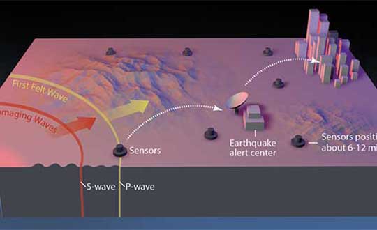
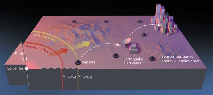
GNSS sensors are installed onshore across the globe, but the majority of megathrust earthquakes occur underwater. To integrate Melgar and Hayes’ findings effectively into earthquake early warning systems would require sensors installed along the seafloor, they noted. “You [would also] need to have fiber-optic cables from shore to the bottom of the ocean, winding around with sensors, and then eventually coming back on shore, and that’s not cheap,” Melgar said.
An additional 10 to 30 seconds of warning to a city or nuclear reactor of an imminent quake would have enormous benefits. But if the hypothesis is wrong, using it now would lead to a greater rate of false alarms and missed quakes, eroding the value of these warnings to society. Melgar and Hayes acknowledged their finding needs to be rigorously tested.
Summarized from Temblor’s website. The Temblor Android app and website provide earthquake, landslide, tsunami and flood information.
Citation
Tripathy-Lang A. (2019), “Can the size of a large earthquake be foretold just 10 seconds after it starts?”. Temblor, http://doi.org/10.32858/temblor.029