The IAG International Symposium on Reference Frames for Applications in Geosciences (REFAG 2022), which is organized by the Aristotle University of Thessaloniki under the scientific coordination of Commission 1 of the International Association of Geodesy, will be held in Thessaloniki, Greece on October 17-20.
REFAG 2022 aims to address today’s theoretical concepts of reference systems and their practical implementation by space geodetic techniques and their combinations, underlying limiting factors, systematic errors and novel approaches for future improvements. The symposium welcomes contributions in all aspects of geodetic reference frames and their applications in Earth science studies, satellite navigation, and also other key areas of geomatics and geospatial information systems.
The scientific program of the symposium covers all topics related to the activities of IAG Commission 1 and its subgroups, including also other initiatives and projects which endorse the role of geodetic reference frames towards scientific exploration, sustainable development, land administration, disaster risk reduction and climate monitoring.
The deadline for abstract submissions for the symposium will be until July 20. Accepted abstracts will be notified by e-mail to the corresponding author by July 30. The submission form and submission information can be found at https://www.refag2022.org/abstract-submission/abstract-general-information/.
Early bird registration is available for REFAG 2022 until July 25. Registration information can be found here.
By Sashidharan Manickam and Kyle O’Keefe PLAN Group, Department of Geomatics Engineering, University of Calgary
This paper analyzes the GNSS signal authentication limits in using different grades of IMU (Tactical and MEMS) to detect errors in combination with different grades of GNSS receiver (Geodetic grade and Automotive). To test these combinations, a tightly-coupled 23 state navigation Kalman Filter is implemented with a constant velocity dynamics model for the position, velocity, attitude and clock states and first-order Gauss-Markov processes to model the 12 sensor errors.
The American Association for Geodetic Surveying (AAGS) has undertaken an effort to explore creating a geodetic certification program. The geodetic certification would provide official recognition that a person has the working knowledge and skills to understand and solve practical problems in applied geodesy.
The vision is that the geodetic certification program would be similar to other existing certifications, such as the American Society for Photogrammetry and Remote Sensing (ASPRS) Certified Photogrammetrist, the GIS Certification Institute (GISCI) GIS Professional, and the National Society of Professional Surveyors (NSPS) and The Hydrographic Society of America (THSOA) Certified Hydrographer.
“As geospatial technology continues to advance and gain wider adoption, geodesy is becoming an increasingly important part of the geospatial framework,” said AAGS past president Michael Dennis, RLS, PE. “To that end, we are exploring the concept of creating a program that officially recognizes professionals with a minimum level of geodetic competence.”
To gain input from industry professionals, AAGS created an online questionnaire about the program and invites all those involved with geospatial technologies to contribute. The questionnaire is available here.
The questionnaire is intended to serve multiple purposes:
Establish an appropriate body of knowledge for applied geodesy
Determine the level of support in the geospatial community
Identify areas of interest and existing status of geodetic knowledge
Provide guidance on creating and prioritizing educational content
Show the breadth and depth of the field of geodesy
Raise awareness of the proposed program
The questionnaire also helps lay the foundation for creating a certification program and consists of 50 questions. The first ten are general questions, and the remaining 40 are divided among the eight topic areas listed below.
Geometrical Geodesy and Reference Systems
Map Projections
Physical Geodesy
Astronomic and Celestial Coordinate Systems
Global Navigation Satellite Systems
Statistics and Least Squares
Geodetic Observation Procedures and Practices
Standards, Specifications, and Guidelines
AAGS is seeking input from a broad cross section of geospatial practitioners, including surveyors, engineers, GIS professionals, photogrammetrists, programmers and any others who use geodetic methods and calculations to combine, manipulate, and analyze spatial data.
The proposed geodetic certification program is being developed in cooperation with the National Society of Professional Surveyors (NSPS). Participation of other professional geospatial organizations is currently being solicited as part of program development.
Topcon Positioning Group announces the release of a new full wave geodetic antenna — the G5-A1. The portable antenna is designed to provide improved multipath mitigation for use with a mobile base station site or network reference station.
“When paired with the Topcon NET-G5 receiver, the zero-centered geodetic antenna provides a powerful and cost-effective entry-level solution” said Charles Rihner, vice president of the Topcon GeoPositioning Solutions Group.
The G5-A1 is optimized for geospatial industries and designed to track all globally available and developing satellite constellations. The antenna weighs approximately 1 pound (.5 kg) and is 7 inches (17.9 cm) wide.
“With its portability and geodetic level performance, the new G5-A1 antenna provides an excellent choice for mobile base system and economy reference station system,” Rihner said.
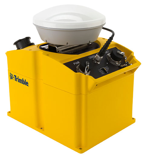
Trimble has introduced an integrated GNSS reference receiver, broadband seismic recorder and a force-balance triaxial accelerometer for infrastructure and precise scientific applications.
The Trimble SG160-09 SeismoGeodetic system provides real-time GNSS positioning and seismic data for earthquake early warning and volcano monitoring as well as infrastructure monitoring for buildings, bridges, dams, as well as other natural and manmade structures.
The Trimble SG160-09 SeismoGeodetic system combines the innovation, reliability and data integrity of both the Trimble and REF TEK brands into a single instrument, Trimble said. The system integrates seismic recording with GNSS geodetic measurement in a single compact, ruggedized package. It includes a low-power, 220-channel GNSS receiver powered by the latest Trimble-precise Maxwell 6 technology and supports tracking of both GPS and GLONASS signals plus the Galileo E1 frequency.
The system includes both the SG160-09 and utilization of Trimble’s CenterPoint RTX correction service, which provides on-board GNSS point positioning. Based on Trimble RTX technology, the service utilizes satellite clock and orbit information delivered over cellular networks or Internet Protocol (IP), allowing cm-level position displacement tracking in real-time anywhere in the world. The SG160-09 system will be available for purchase without the RTX correction service for those applications using real-time kinematic (RTK) positioning.
The seismic recording sensor includes an ANSS Class A, low-noise, force-balance triaxial accelerometer with the latest, low-power, 24-bit A/D converter, which produces high-resolution seismic data. The internally built accelerometer has +/- 4g full scale output, large linear range, high resolution and sensitivity, which makes it ideal for both portable and permanent deployment. The SG160-09 processor acquires and packetizes both seismic and geodetic data and transmits it to system operators using an advanced, error-correction protocol with back-fill capability providing data integrity between the field and the processing center.
The SG160-09 system is ideal for earthquake early warning studies and other hazard mitigation applications, such as volcano monitoring, building, bridge and dam monitoring systems. The SG160-09 system features a variable size industrial grade USB drive to support real-time telemetry data transmission. In the event of a telemetry link outage, the data is stored on the USB drive and can be re-transmitted to the centralized processing station as soon as the communication link comes back up, allowing no data loss during the system operation.
The Trimble SG160-09 system is optimized for field use with instrument mounted or externally mounted GNSS antenna configurations. The lightweight yet rugged SG160-09 consumes very little power and can be used for projects with remote connectivity and in extreme weather conditions. Because the SG160-09 combines both GNSS and strong motion in a single instrument, site installation time is reduced, data communications flow through a single pathway, and station power infrastructure is streamlined, making the SG160-09 a cost competitive solution compared to other systems on the market today. It has an IP67 rating, which means it is sealed against dust and can be submerged in water up to a meter for approximately 30 minutes. The SG160-09 also meets MIL-STD 810F standard for drops, vibration and temperature extremes.
“The SG160-09 is another example of Trimble’s on-going focus in GNSS and seismic technology for the scientific and engineering communities,” said Ulrich Vollath, general manager for Trimble’s Infrastructure Division. “Trimble has developed a combined state-of-the-art GNSS receiver with a high-dynamic range, low-noise accelerometer that provides dynamic monitoring with the flexibility required for today and tomorrow’s challenges.”
The Trimble SG160-09 SeismoGeodetic system is expected to be available in the fourth quarter of 2014.