Nestwave has released a white paper that considers the challenges associated with integrating accurate geolocation into compact, battery-powered, low-cost internet of things (IoT) nodes.
The technical paper “Minimizing Power Budgets to Enable Geolocation on Every IoT Device” is targeted at engineers and developers looking to add accurate positioning functionality to IoT technologies where power requirements must be kept to an absolute minimum.
Topics covered include:
why conventional tracking architectures are not suitable for many IoT implementations
the importance of factors such as time-to-first-fix (TTFF)
the number of fixes and levels of integration in determining power consumption.
The paper introduces new ways of handling positioning signal acquisition, ranging and tracking, and proposes solutions that eliminate the need for a separate GNSS-integrated circuit and that offload energy-intensive computation to the cloud.
“Tracking will be an important element in the evolution of the IoT, which means making accurate geolocation viable for every single IoT node is absolutely critical,” said Ambroise Popper, Nestwave CEO. “This paper explains why traditional solutions are too power-hungry, too large and too expensive to meet the energy, form factor and cost constraints of most IoT devices and introduces solutions for addressing the challenge.”
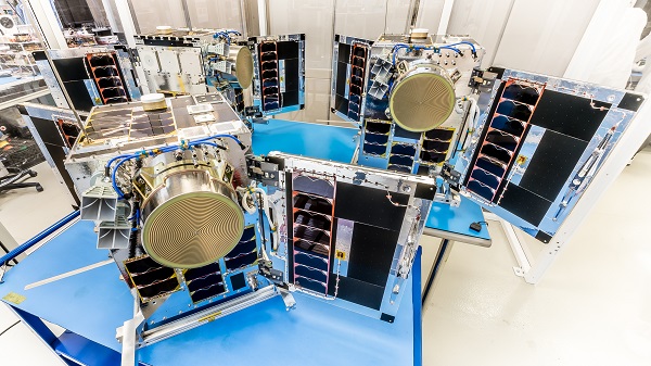
Three HawkEye 360 radio-frequency geolocation microsatellites were launched May 25. The satellites, launched aboard SpaceX Transporter-5 mission, were built by Space Flight Laboratory (SFL) of Toronto. Three SFL-built satellites for greenhouse gas monitoring were also launched.
The HawkEye 360 constellation detects and geolocates RF signals for maritime situational awareness, emergency response, national security and spectrum analysis applications.
Once Cluster 5’s on-orbit checkout is complete, the HawkEye 360 constellation will be expanded to 15 satellites, doubling capacity and revisit rates. This significantly boosts the constellation’s ability to serve global customer demand and to monitor activity across places such as Ukraine.
“Every enhanced satellite cluster we launch helps us deliver a higher density of valuable data to our government, commercial and humanitarian customers and partners – advancing our efforts to monitor global activities for a safer and more secure world,” said HawkEye 360 John Serafini. “Launch by launch, these space-based innovations are analyzing the knowns and uncovering the unknowns of the RF spectrum across the globe.”
Cluster 5 includes enhanced antenna functions introduced with Cluster 4, which allow greater flexibility in geolocating signals across a wide range of frequencies important to customers.
Cluster 4, launched April 1, has been completing checkout and moving into final formation to begin collecting data in late June. Cluster 5 is slated to achieve initial operating capability in August.
Cluster 4 on orbit. (Image: HawkEye 360)
HawkEye 360 plans to continue to grow the constellation to achieve revisit rates of about 15 minutes to support timely defense, national security and commercial applications.
SFL has now developed 15 microsatellites for HawkEye 360 of Herndon, Virginia. SFL was selected for these missions due to the importance of formation flying by multiple satellites for successful RF geolocation.
Other missions developed by SFL in the past two years include 16 communications CubeSats and three microsatellites designed for Earth observation, maritime tracking and atmospheric monitoring.
In its 24-year history, SFL has developed cubesats, nanosatellites and microsatellites that have achieved more than 191 cumulative years of operation in orbit.
The new LoRa Edge LR1120 enables satellite-based networks and simplifies terrestrial network interoperability
Image: Semtech
Semtech Corp. has added multi-band capabilities to its LoRa Edge device-to-cloud geolocation platform.
The LoRa Edge LR1120 allows for direct satellite-connected internet of things (IoT) applications in supply-chain management and logistics with seamless low-power geolocation on a global scale, the company said.
“Semtech’s LoRa is targeting track and trace challenges faced by the logistics industry today with a geolocation IoT platform adapted to global transportation and mass-scale asset management,” said Marc Pégulu, vice president of IoT product marketing for Semtech’s Wireless and Sensing Products Group. “With the launch of multi-band LoRa support, coupled with LoRa Cloud services, it has never been easier to expand ubiquitous IoT connectivity and geolocation globally.”
With LoRa Edge LR1120, intercontinental logistics companies can leverage highly integrated, ultra-low-power trackers with enhanced interoperability, more versatile connectivity for a simpler operation, and global mobility across multiple regulatory regions, Semtech said. Additionally, the possibility to offer a low-power and low-cost sensor with satellite connectivity unlocks a multitude of use cases in infrastructure monitoring, agriculture and environmental monitoring that require deployment in remote areas, which tend to be capital intensive.
“Combining LoRa with small, relatively low-cost LEO satellites will change the game for LoRa and IoT,” said Christopher Taylor, director, RF & Wireless with Strategy Analytics. “Adding satellite communication capabilities in the S-band to LoRa can help replace aging SCADA monitoring and opens up new applications and markets, especially in remote regions. So far, LoRa has attracted the interest of several satellite companies including EchoStar and Lacuna.”
Key Features of LoRa Edge LR1120:
multi-band LoRa capability (sub-GHz, 2.4 GHz and licensed S-band for satellite) and multi-technology geolocation using GNSS for outdoor and Wi-Fi for indoor, as well as areas where satellite coverage is poor
LoRa Cloud geolocation solver, which transfers the location processing workload from the device to the cloud, making “deploy once” battery life possible
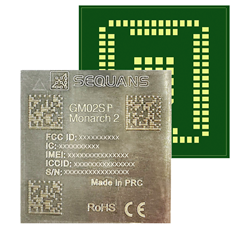
Nestwave is collaborating with Sequans to deliver accurate and efficient GNSS positioning for low-power internet of things tracking
The Nestwave IP provides the latest Sequans LTE-M/NB-IoT platform with geolocation. (Photo: Sequans)
Nestwave has announced that its technology has been selected by Sequans Communications S.A., provider of 5G/4G cellular internet of things (IoT) connectivity solutions. Specifically, Nestwave’s technology will add GNSS positioning to the Sequans Monarch 2 LTE-M/NB-IoT platform.
Integrated into the Sequans Monarch 2 GM02SP module, the Nestwave GNSS solution offers Sequans’ IoT customers accurate positioning with ultra-low-power consumption while minimizing component count, cost and size by removing the need for an external positioning chipset.
This makes the Sequans platform suitable for a wide variety of intermittent, power-limited tracking use cases including personal trackers, parcel and pallet location, and fleet trackers, as well as car, bike and scooter location and theft recovery. Cosmo Connected, a leader in urban mobility solutions, has already adopted the Monarch 2 GM02SP solution to reduce the cost and power consumption of its tracker products.
Nestwave’s technology allows geolocation to be added to existing IoT chipsets by implementing a GNSS receiver using the chip’s existing radio and computing capabilities. This eliminates the need for an external GNSS chipset and product redesign.
“Nestwave’s technology provides the smallest, most power efficient, and lowest component count solutions for IoT geolocation,” said Nestwave CEO Ambroise Popper. “Our strategic partnership with Sequans addresses the challenge of integrating accurate geolocation into compact, often battery-powered, low-cost IoT nodes and allows Sequans customers to benefit from higher performing, lower cost tracking solutions.”
“Leveraging Nestwave’s innovative technology to provide low-power GNSS on Monarch 2 widens its capabilities and makes many types of IoT tracker use cases more affordable because there is no need for additional positioning chips or modules,” said Georges Karam, Sequans CEO.
Nestwave IP has been integrated into a variety of chip architectures and on various DSP/CPU cores. In combination with Nestwave cloud services, this IP enables a very short time-to-first-fix, which allows for much lower power consumption in tracking use cases, without compromising on sensitivity or accuracy. The company’s technology roadmap includes the addition of 5G/4G cellular-based hybrid location functionality and solutions that will improve the accuracy of indoor tracking.
The U.S. Army’s Assured Positioning, Navigation and Timing/Space Cross-Functional Team has approved the Navigation Warfare Situational Awareness Abbreviated Capability Development Document (A-CDD), signed March 25.
The A-CDD validates the operational need and enables experimentation and rapid prototyping for NAVWAR-SA capabilities for the warfighter.
NAVWAR is deliberate offensive and defensive actions to assure friendly use and prevent adversary use of positioning, navigation and timing information. NAVWAR supports Multi-Domain Operations as an enabler to precision fires, movement and maneuver, force tracking, and a host of data networks that tie personnel and weapon systems together into a joint or coalition force.
NAVWAR-SA provides the capability to detect, identify and locate sources of interference that deny or degrade reception of PNT. It is intended to validate PNT signal integrity and provide users with indication and warnings of the presence and intensity of interference.
NAVWAR-SA will also characterize the operating environment through the integration of multiple sensors that are able to detect, identify and geolocate sources of intentional and unintentional interference.
William Nelson, Director, APNT CFT
“This A-CDD will enable us to accelerate critical NAVWAR technology development and streamline the process of expediting an operationally relevant system to our warfighters,” said Willie Nelson, director for the APNT/Space CFT. “This capability will enhance our ability to provide real-time situational awareness of PNT reliability to soldiers and commanders on the battlefield, which will enable Long-Range Precision Fires and support freedom of maneuver of large scale ground combat operations.”
NAVWAR-SA will give the Army Forces the ability to “sense” the PNT environment in real-time, allowing commanders and units to maneuver with confidence and with precision when the global positioning system is degraded or denied. This is critical element of NAVWAR operations.
The APNT CFT coordinated with organizations across the modernization enterprise to get the NAVWAR-SA A-CDD approved. The Army Capability managers for Space and High Altitude played a major role in developing the written requirement and getting it through the approval process.
“The requirements provided in the NAVWAR-SA A-CDD are a first step in developing dedicated NAVWAR capabilities for our soldiers and are a key enabler in enhancing lethality in combat operations,” said Col. Tim Dalton, Army Capability manager for Space and High Altitude director.
The A-CDD details methods to leverage new and existing solutions for rapid prototyping, testing and soldier assessment. The APNT/Space CFT will utilize the “buy, try and decide” process to accelerate the development of critical enabling technologies and streamline the process of transitioning a scalable, interoperable and agile capability to the field. This process will inform NAVWAR-SA requirements for current and future Army systems.
“NAVWAR-SA will strengthen the Army’s ability to conduct military operations in PNT-challenged environments,” said David Pinckley, NAVWAR director for the APNT/Space CFT and chairman of the NATO NAVWAR Capabilities Team. “The unfortunate reality is that our systems will continue to be challenged by our adversaries so we are working with our joint and coalition partners to preserve military capabilities while mitigating impacts of interference.”
NAVWAR is one of the three APNT/Space CFT Signature Efforts, which will deliver offensive and defensive NAVWAR capabilities in conjunction with existing Department of Defense NAVWAR policies.
Joint and coalition forces conducting military operations will employ NAVWAR-SA to coordinate and implement mitigating actions to overcome PNT challenged environments.
The APNT/Space CFT plans to assess and test NAVWAR-SA prototypes later this year, during Project Convergence 21 and the CFT’s annual PNT Assessment Exercise at the White Sands Missile Range, New Mexico.
The collaboration will provide designers with a power-efficient, high-accuracy GPS solution for battery-operated devices without the additional cost of a dedicated GNSS chip.
“Today’s advanced navigation systems are facing unique challenges when being implemented in power-constrained IoT devices,” said Ambroise Popper, CEO at Nestwave. “By combining Nestwave’s low-power geolocation software with Synopsys’ efficient ARC IoT Communications IP Subsystem, we can deliver a geolocation solution that offers greater accuracy, lower power consumption, and lower cost compared to existing GNSS solutions.”
Ultra-low bandwith IoT applications
The ARC IoT Communications IP Subsystem is an integrated hardware and software solution that combines Synopsys’ DSP-enhanced ARC EM9D processor, hardware accelerators, dedicated peripherals and RF interface to deliver efficient DSP performance for ultra-low bandwidth IoT applications.
Nestwave’s GNSS solution takes advantage of the ARC EM9D processor’s efficient DSP capabilities and ability to add dedicated hardware accelerators or custom instructions using APEX technology to reduce frequency requirements, giving customers additional performance bandwidth.
The ARC EM9D processor is supported by the MetaWare Toolkit, which includes a rich library of DSP functions, allowing software engineers to rapidly implement algorithms from standard DSP building blocks.
Geolocation for emerging applications
Nestwave has developed an ultra-low power, advanced GNSS solution for use in IoT applications. When integrated with an IoT modem such as NB-IoT, Cat M1, LoRa or Sigfox, the solution offers low-cost geolocation for emerging applications such as asset tracking, smart factories, and smart cities, without the need for an external GNSS chip.
“Emerging IoT applications are demanding geolocation functionality with high-accuracy and ultra-low power consumption,” said John Koeter, senior vice president of marketing and strategy for IP at Synopsys. “The combination of Synopsys’ ARC IoT Communications IP Subsystem with Nestwave’s GNSS technology will help designers significantly improve geolocation performance, reduce frequency requirements and lower overall power consumption for battery-powered IoT applications.”
Semtech Corporation, supplier of high-performance analog and mixed-signal semiconductors and advanced algorithms, has launched LoRa Edge, a versatile and low-power software defined LoRa-based platform.
Semtech said LoRa Edge will enable a wide portfolio of applications for indoor and outdoor asset management, targeting industrial, building, home, agriculture, transportation and logistics markets.
The first product from this portfolio is a geolocation solution for development of internet of things (IoT) devices for asset management applications. It features low-power Wi-Fi and GNSS sniffing capabilities combined with LoRa Cloud geolocation and device management services to significantly reduce the cost and complexity of locating and monitoring IoT assets.
“Semtech continually delivers internet of things (IoT) solutions that simplify and accelerate the development of LPWAN applications,” said Pedro Pachuca, director of IoT Wireless in Semtech’s Wireless and Sensing Products Group. “LoRa Edge and LoRa Cloud geolocation services enable customers to develop ultra-low power applications for a variety of industries and will expand the mass adoption of LoRa in the IoT ecosystem.”
Over the next decade, 500 billion devices are expected to connect to the internet (according to Cisco), as organizations continue to shift towards a more IoT-focused business strategy, and the majority of those IoT devices require some form of localization capability either at point of install or through the assets life.
The LoRa Edge geolocation platform will enable solution providers to leverage the unique localization capabilities of LoRa as well as GNSS and Wi-Fi scanning capabilities from a single chip solution, allowing customers to choose the best localization tool for the application task they are addressing.
By removing the need for incremental GNSS and Wi-Fi components, LoRa Edge reduces the bill of material (BOM) costs of devices and significantly reduces design and procurement complexity, Semtech said.
The first LoRa Edge chipset targeted with geolocation (LR1110) is available today; more products from this portfolio will be released in the first half of this year.
Product Features
Multi-Purpose Radio Front-End
150 – 2700 MHz continuous frequency synthesizer range
GPS/BeiDou scanning
Wi-Fi passive scanning
Low-Power LoRa/(G)FSK RF Transceiver
Worldwide frequency bands support in the range 150 – 960 MHz
High power PA path +22 dBm
High efficiency PA path +15 dBm
Fully compatible with the LoRaWAN standard
Cryptographic Engine
Hardware support for AES-128 encryption/decryption based algorithms
Handling device parameters such as DevEUI and JoinEUI
Protects confidential information such as encryption keys
Stores NwkKey, AppKey, as defined in the LoRaWAN standard
Space Flight Laboratory (SFL) has launched three formation-flying HawkEye 360 Pathfinder 15-kilogram, 20 x 27 x 44-centimeter microsatellites designed to detect and geolocate radio frequency (RF) signals.
Hawkeye 360 Pathfinder satellite trio flies in formation, seeking RF signals from Earth. (Image: UTIAS Space Flight Laboratory)
The target signals emanate from VHF radios, maritime radar systems, automatic identification system (AIS) beacons, very small aperture terminal (VSAT) communication systems and emergency beacons. HawkEye 360 applies advanced RF analytics to the data to assess suspicious vessel activity, survey communication frequency interference and direct search-and-rescue.
Precise formation flying is critical, as the relative position of each satellite must be known to accurately geolocate transmission sources. The satellites carry space-qualified GPS receivers and high-performance attitude control systems to keep them stable in orbit.
Flying in formation, two or all three satellites may receive the same transmission when it originates from their common footprint. The signal’s different times of arrival at each satellite and their different apparent center frequencies (Doppler) will enable onboard comparison of time-of-arrival and frequency-of-arrival measurements to then calculate the transmitter’s position.
The onboard GPS receivers provide precise estimates for the position and velocity of the receivers, information required for multilateration. The satellites further synchronize their clocks using GPS receivers, which also stabilize the phase-locked loops governing the tuning frequency in the RF tuners.
The satellites were built by Deep Space Industries of San Jose, California, and University of Toronto, Institute for Aerospace Studies/Space Flight Laboratory (UTIAS/SFL). They were launched in December 2018 into low-Earth orbit.
A new company, hoopo, has launched to supply an innovative, accurate geolocation solution for low-power wide area (LPWA) networks. The solution would improve precision for low-power Internet of Things (IoT) asset tracking.
Hoopo’s geolocation enables companies to locate their valuable assets without the significant cost or battery consumption that can be associated with GPS. hoopo’s IoT solutions help companies precisely track specific assets in areas such as shipping ports, airports, car dealer lots, cattle ranches and other asset-dense areas.
Hoopo has received $1.5 million in funding to further grow its business from a group of investors, including the initial investors in Mobileye; Israeli investor Zohar Gilon; and Ben Marcus, CEO of AirMap.
The need to understand and quantify asset location is quickly becoming a requirement for the enterprise and industrial IoT. However, the accuracy of today’s low-power geolocation isn’t precise enough to deliver on the full promise of the IoT.
LPWA networks are becoming the driving force behind smart city and other IoT applications because of their low-cost, low-power consumption, and high-coverage capabilities in rural and urban environments. The long battery life of LPWA devices allows businesses to deploy a maintenance-free device in the field for several years.
“Hoopo is addressing a real business need of companies around the world: cost-effective, yet precise, tracking of their valuable assets with longevity of battery life up to 10 years in the field,” said Ittay Hayut, CEO of hoopo. “LPWA checks off all of the boxes companies need in terms of cost and coverage, and hoopo’s solutions work alongside these LPWA networks to help businesses keep their assets safe, anytime and anywhere.”
Hoopo’s solutions are based on a patent-pending triangulation method that uses LPWA data transmissions to generate a precise location. The solutions suite includes low-cost LPWA gateways and devices, as well as a platform for management and real-time notifications. Companies can receive on-demand geolocation, establish geofences, receive movement alerts, and more, ensuring the protection of their valuable assets.
“Hoopo’s geolocation technology reveals new business verticals that were limited or impossible when using existing technologies because of their high-cost and significant power consumption,” said Menashe Terem, CEO at Tri-logical, a provider of tracking and management solutions.
“Early applications such as asset tracking are just the beginning of what advances in geolocation will enable,” said Eli Fogel, former CTO at Intel and hoopo investor. “Just as the advent of GPS launched a wealth of applications that no one ever thought of before, such as location-based advertising, there are future applications that this next generation of geolocation technology will enable. We’re excited to see what new applications emerge as customers embrace these new precision location capabilities.”
Hoopo is displaying at Mobile World Congress in Barcelona Feb. 26-March 1 in Hall 5, Stand 5D81.
As government agencies expand their use of cell-site simulators or “stingrays” and other digital tracking technology, Sen. Ron Wyden, D-Ore., Rep. Jason Chaffetz, R-Utah, and Rep. John Conyers, Jr., D-Mich., introduced the Geolocation Privacy and Surveillance Act (known as the GPS act) to create clear rules for when agencies can access and track an individual’s geolocation information.
Chaffetz introduced the House version of the bill on March 6, with four Republican and three Democratic cosponsors. Wyden introduced the Senate bill Feb. 15.
Courts have issued conflicting opinions about whether the government needs a warrant to track Americans through their cell phones and other GPS devices. The Supreme Court unanimously ruled in 2012’s U.S. vs. Jones case that attaching a GPS tracking device to a vehicle requires a warrant, but it did not address other digital location tracking, including through cell phones, OnStar systems and consumer electronics devices.
The GPS Act applies to all domestic law enforcement acquisitions of the geolocation information of individual Americans without their knowledge, including acquisitions from private companies and direct acquisitions through the use of cell-site technology. It would also combat high-tech stalking by creating criminal penalties for surreptitiously using an electronic device to track a person’s movements, and it would prohibit commercial service providers from sharing customers’ geolocation information with outside entities without customer consent.
Wyden and Chaffitiz have now introduced versions of the GPS Act four times since 2011. Though hearings have been held, the Act has yet to make it out of committee for a vote.
“Outdated laws shouldn’t be an excuse for open season on tracking Americans, and owning a smartphone or fitness tracker shouldn’t give the government a blank check to track your movements,” Wyden said. “Law enforcement should be able to use GPS data, but they need to get a warrant. This bill sets out clear rules to make sure our laws keep up with the times.”
“Congress has an obligation to act quickly to protect Americans from violations of their privacy made possible by emerging technologies,” Chaffetz said. “As we welcome innovative technologies that help fight crime, we must be mindful of the potential for abuse. This bill will build a framework governing the use of geolocation and cell site simulator technologies.”
“We must enact the Geolocation Privacy and Surveillance Act to require the government to obtain a warrant based on probable cause to compel companies such as cell phone service providers to disclose the geolocation information of their customers,” said Rep. John Conyers, Jr. (MI-13). “Geolocation tracking, whether information about where we have been or where we are going, strikes at the heart of personal privacy interests. The pattern of our movements reveals much about ourselves. When individuals are tracked in this way, the government is able to generate a profile of a person’s public movements that includes details about a person’s familial, political, professional, religious, and other intimate associations. That is why we need this legislation to provide a strong and clear legal standard to protect this information.”
Support for the Act
Technology and civil rights organizations praised the bill’s introduction.
Neema Singh Guliani, legislative counsel at the American Civil Liberties Union: “In today’s world, most Americans use cell phones or other electronic devices that are capable of tracking their every move, including visits to a mosque, doctor’s office, domestic violence shelter, or political rally. This information that the government should not be able to get without a warrant – yet law enforcement routinely fails to meet this standard. Congress should swiftly pass the GPS Act to protect this sensitive information.”
Gabe Rottman, deputy director of the Freedom, Technology & Security Project at the Center for Democracy and Technology: “As we move into the world of connected devices, and as the sheer number of these devices grow, location tracking becomes more accurate, and more revealing. Basic notions of American privacy necessitate passage of this important reform to require a warrant for location tracking.”
Amie Stepanovich, U.S. policy manager at Access Now: “Computer scientists have proven that even a few location points can be used to reveal incredibly broad and personal information about an individual. At the same time, ever more devices are collecting our location data. Law enforcement agencies are using an increasingly sophisticated array of technology to obtain that information without proper legal protections. What you don’t know can hurt you. Access Now applauds the GPS Act for protecting this sensitive information and mandating a warrant requirement for law enforcement access.”
Lee Tien, senior staff attorney at the Electronic Frontier Foundation: “Geolocation data paints a detailed portrait of our daily lives that reveals sensitive information about us and our families — whether a visit to a children’s cancer specialist or to a church, synagogue or mosque. The government shouldn’t be able to track us without a warrant just because we use cellphones. The GPS Act ensures all Americans have strong legal protections for their geolocation data.”
The first and best step to combat the growing worldwide problem of GPS jamming is to pursue technologies that can detect and locate the jammers. Signal Sentry 1000 uses arrayed sensors to do just that: look out for jamming and track down its source once sensed.
An array of sensors can be deployed for sensitive and high value entities such as infrastructure installations, including airports, railroads, chemical plants, electric power plants and grids, cargo ports, wireless communication systems and financial transfer centers. The sensors will connect to servers that assimilate the sensor data and provide operator interfaces.
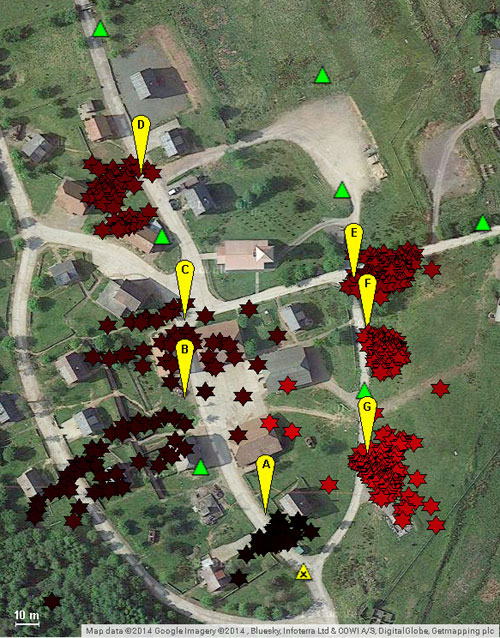
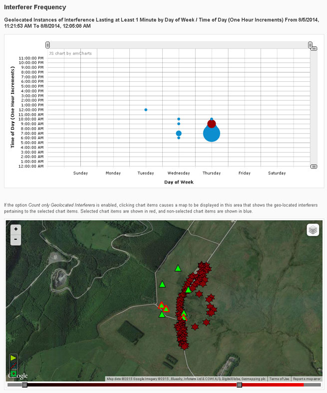
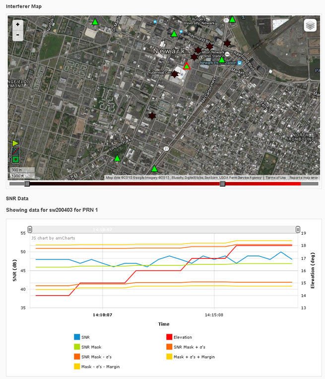
Signal Sentry 1000 is based on a server/client model. The user accesses Signal Sentry using a URL and secure log-in specific to the user’s system. The user’s particular home screen displays a map with each installed sensor displayed with an icon reflecting status. Interferers are displayed as red stars or as error ellipses.
The Signal Sentry web page lists all the interferers stored in the database with their start and end times. The user can manipulate the list by changing the minimum duration of the event to be displayed as well as if the interferer had been geolocated or not, or both. If an interference event was less than a minute long, it may not have a geolocation entry.
Geolocation Methodology. Geolocation of jammers is accomplished through proprietary algorithms running at the network server that utilize digitized, timestamped I and Q samples of received interference waveforms, GPS observables, and other parameters captured by each sensor. This data is processed in a Kalman-filter based location algorithm to determine an initial jammer position and track the position of the jammer throughout the jamming event. This improves performance with moving jammers (that is, vehicle-based) and enables continued jammer location with a limited sensor set (potentially due to signal blockage, erroneous data due to multipath, or out-of-range conditions). Upon detection of an interference event by any sensor, the server polls the entire sensor network for data and determines if the information is sufficient to perform geolocation.
The user receives near-real-time status of event detections and geo-location of the interferer (if possible). Sensor data polling, geolocation processing and GUI updates continue until the interference stops or the emitter goes out of sensor range. Sensor data from each event is stored for later replay and processing using Signal Sentry event analysis tools.
An interference event frequency chart (Figure 1) provides a tool for forensically evaluating the occurrence of interferers. It displays interference events as circles; the size of the circle represents the number of events that occurred at that day of the week and time. When dots are selected on the chart, a map below the chart shows the location of the interference events. More than one dot can be selected at a time. This allows a user to find correlations in time and space, to determine if events occur at specific locations at certain times of the day and/or days of the week.
FIGURE 1. Interference event frequency chart.
Selecting the interferer on the map and then the details button on the popup brings up the interferer details page (Figure 2). Users can sign up for interferer alerts to be sent to their email or phone by text.
FIGURE 2. Interferer details.
Testing
Signal Sentry 1000 was deployed and tested in GPS jamming trials at Sennybridge, United Kingdom, in August 2014. Testing included stationary jammers and mobile jammers moving at up to 50 mph, in open fields and built-up areas.
Sentry Arrayed. The sensors used in these trials were custom units designed and built to Harris specifications by Chronos Technology Ltd. Each consisted of an embedded GPS receiver, an interference signal receiver and a local processor with a network communications interface.
An array of eight sensors was geographically distributed around the test facility. Each sensor and a centralized Signal Sentry processing server were equipped with a mesh data networking capable radio for wireless data communications of commands, status and event data. In other Signal Sentry deployments, the server software is typically hosted on a cloud server, and sensors communicate with the server either via hard-wired internet connections or wirelessly through cellphone network-compatible data adapters.
Jammer Profile. Two jammers performed during the trials, a 150mW and a .5W jammer, used to disrupt the GPS L1 C/A code at 1575.42 MHz.
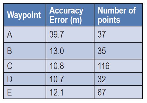
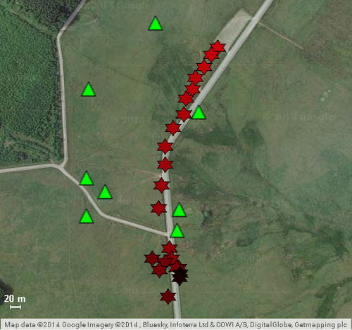
Open Field. Atest in an area with no obstructions included static jammers and dynamic jammers. Five waypoints along the road, in an area measuring 320 by 444 meters, were surveyed prior to the test using a handheld GPS receiver, to evaluate location accuracy.
Table 1 shows static test results. The accuracy error is the average delta between the Signal Sentry-reported jammer positions versus the actual surveyed jammer positions. The number of points column contains the number of measurements reported by Signal Sentry during the test scenario for each waypoint. The overall average accuracy error for the static jammer test was 17.25 meters.
TABLE 1. Open field static accuracy.
Open Field, Mobile Jammer. In these tests, the jammer was driven in a car on the road through the sensor field. The car was driven at 25 mph north to south, then 50 mph south to north (Figure 3). Cars in the north parking lot caused multipath errors when the jammer came in contact with that area.The overall average accuracy error for the dynamic tracking was 10 meters.
FIGURE 3. Jammer locations detected by Signal Sentry, when jammer was driven at 50 miles per hour, north to south. Green triangles denote sensor locations.
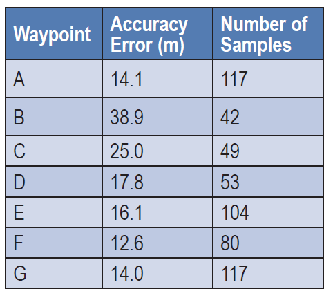
Obstructed Area Test. This test evaluated performance in an urban environment called a FIBUA (Fighting in Built-up Areas), using stationary and dynamic jammers. Seven waypoints in an area 176m x 253m were surveyed for the purpose of evaluating location accuracy. Table 2 shows the results with the 150mW jammer held stationary at the waypoints. Figure 4 provides a graphical view of the jammer position in relation to the waypoints. The overall average accuracy error is 21.40 meters.
TABLE 2. Urban static accuracy.
Obstructed Area, Mobile Jammer. In these tests, the jammer was driven in a car at approximately 20 mph on the road through the sensor field, using a .5W jammer. The overall average accuracy error for this dynamic tracking was 50 meters.
FIGURE 4. Urban area test; jammer locations in yellow, locations delivered by Signal Sentry in red, sensor locations in green.
All figures provided by Jeffrey Coffed and Joseph Rolli.
MemSQL, which specializes in real-time databases for transactions and analytics, has announced new geospatial capabilities for its in-memory, distributed SQL-based database. By bringing together geospatial and operational data in the same high speed database, customers can achieve unprecedented agility for geospatial analysis, MemSQL said.
Unlike segregated solutions, MemSQL integrates geospatial data as a primary data type, making it as easy to use and operate at scale with as much speed and high throughput as any other class of data.
Previously, enterprises were forced to segregate their geospatial data into separate data stores. With the rise of IoT and mobility, nearly all data is location-specific. As data volume increases, maintaining geolocation information outside of the primary datastore leads to longer latency and synchronization challenges.
By integrating geospatial functions, MemSQL enables enterprises to achieve greater database efficiency with a single database that is in-memory, linearly scalable and supports the full range of relational SQL and geospatial functions. With MemSQL, geospatial data no longer remains separate and becomes just another data type with lock-free capabilities and powerful manipulation functions.
Taxi Scenario with Esri.Working with MemSQL and Apache Spark, Esri analyzed data compiled from 170 million real-world New York City taxi rides around the GPS coordinates of pickups and dropoffs, as well as distance and travel time. Slicing by hour of the day, Esri can calculate the average speed of a taxi ride and find the best and worst places for traffic jams. Slicing by day of the week, the ebb and flow of traffic during workdays and weekends becomes visible.
For a city planner, this data insight can be used to redirect traffic at specific times in an effort to unclog traffic congestion. For the taxi business, this data can improve efficiency with supply and demand of cabs during times of high or low traffic for any given region.
“MemSQL is enabling companies to consolidate many niche solutions into fewer, more capable multi-purpose solutions. By making geospatial data a primary part of in-memory, operational databases, our customers can rely on one solution to make their data more valuable,” said Eric Frenkiel, MemSQL co-founder and CEO. “We’re delivering on our promise of easy access to database innovation and are quickly becoming the go-to-company to help enterprises operationalize analytics.”
MemSQL will showcase the MemSQL, Apache Spark and Esri demonstration at Spark Summit East 2015 on March 18-19 at The Sheraton New York Times Square Hotel. Visit MemSQL at Booth 13 during show expo hours.
The early access MemSQL geospatial capabilities are available now and will be generally available in calendar Q2. Read the technical blog post here.