Tag: GeoOptics

  • GeoOptics upgrades CICERO constellation to track climate change

    GeoOptics upgrades CICERO constellation to track climate change

    Graphic: Petrovich9/iStock/Getty Images Plus/Getty Images
    Graphic: Petrovich9/iStock/Getty Images Plus/Getty Images

    CICERO-2 satellites will track Earth’s atmosphere, water, surface and interior

    Remote sensing company GeoOptics Inc. has upgraded its CICERO constellation of satellites that measure the Earth’s climate. With launches beginning next year, CICERO-2 will form a unified Earth observatory allowing governments, industry and individual stakeholders to monitor and prepare for the impacts of climate change.

    “In today’s environment, in which precision Earth sensing is becoming ever more critical, GeoOptics is deploying a flexible observatory made up of dozens of small satellites,” said Alex Saltman, Chief Executive Officer of GeoOptics. “The real time services will satisfy a broad range of needs for government and civil users around the world.”

    The first CICERO-2 satellites launched are designed to achieve key milestones in small satellite Earth observation, including:

    • Advanced GNSS reflectometry (GNSS-R). Advanced GNSS-R measures many phenomena near Earth’s surface, including ocean winds, flooding, land cover (snow, ice, vegetation), soil moisture and topography by means of reflected GNSS signals. NASA’s recent CYGNSS mission demonstrated the broad utility of the GNSS-R technique. GeoOptics is working with NASA’s Jet Propulsion Laboratory (JPL) to deploy an advanced operational version, offering dramatically enhanced performance in a small, low-cost package. This collaboration is funded jointly by GeoOptics, the U.S. Air Force, and NASA.
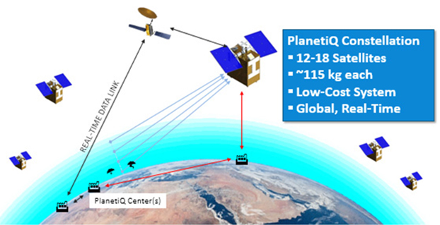
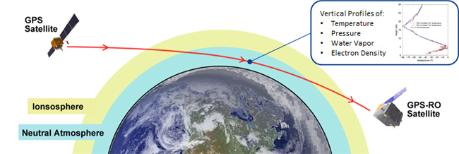
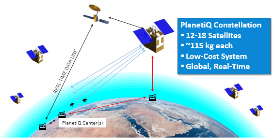
    • Triple radio occultation (GNSS-RO). GNSS-RO enables Profiling of atmospheric temperature, pressure, density and other key properties. First proposed by company founder Tom Yunck while he was at JPL, GNSS-RO offers extreme measurement precision and is an essential contributor to global weather forecasting. The CICERO-2 satellites will yield three times the data volume of their predecessors and many times the volume.
    • Global precipitation watch.  The CICERO-2 satellites will monitor heavy precipitation using polarimetric radio occultation (RO), an advanced remote sensing technique pioneered by GeoOptics’ collaborators at JPL and the Spanish PAZ mission.

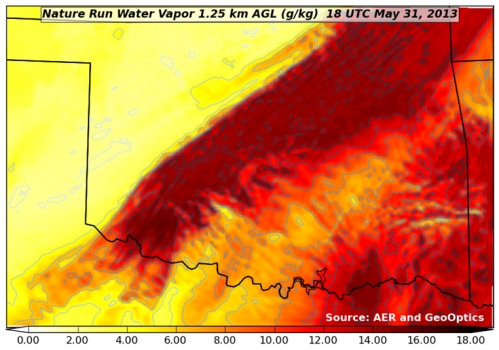
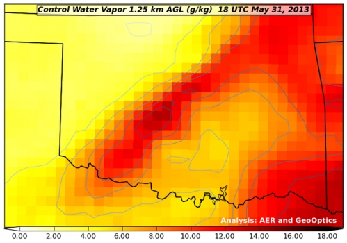
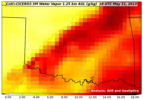
    Measuring weather changes

    For GeoOptics’ strategic partner Climavision, a weather data provider, these innovations will enable customers to manage significant risks in a time of global change. “With these new developments in remote-sensing technologies from GeoOptics, we’ll be able to further enhance our climate and weather prediction capabilities,” said Chris Goode, CEO and co-founder of Climavision. “Through the combination of advanced RO profiles, GNSS-R data about surface conditions and our proprietary gap-filling radar network data, we’ll help customers in weather-sensitive industries see weather like never before and give them the tools and data to make informed critical decisions.”

    GeoOptics will later extend the system to a range of new applications, including precise mapping of Earth’s gravitational field, which has been named a top NASA Earth science priority for the next decade. This measurement shows the imprint of climate-related movement of water and other key changes in the Earth.

    With internal investment and nearly $4 million from NASA, GeoOptics has devised a unique system architecture for daily gravity mapping with clusters of small satellites. This patented technique promises to improve gravity sensing 20-fold over current methods at a fraction of the cost.

    Under the umbrella of the National Oceanographic Partnership Program (NOPP), GeoOptics is also designing a radar instrument to observe ocean vector winds, topography, soil moisture and a variety of other surface properties with patented multi-satellite radar techniques. NOPP is seeking to sponsor a trial flight of GeoOptics’Cellular Ocean Altimetry/Scatterometry Technology (COAST) within the next two years.

    Tom Yunck, GeoOptics’ Chief Technology Officer, said, “These advanced remote sensing applications – from basic RO to advanced radar and gravity mapping – exploit shared micro technologies that fit in the palm of one’s hand. Each new function builds naturally upon the previous, yielding prodigious observing capacity in a low-cost system of great simplicity and reliability.”

    “CICERO-2 is designed to help provide high-priority NOAA climate and weather monitoring observations, as ranked by the NOAA Space Platform Requirements Working Group (SPRWG),” said Conrad C. Lautenbacher (Vice Admiral, USN ret.), executive chairman of GeoOptics and former National Oceanic and Atmospheric Administration (NOAA) administrator. “It can also play a key role in supporting crucial Defense Department satellite weather data requirements.”

    GeoOptics’ CICERO satellites continue to provide precise global profiles of the Earth’s atmosphere. In February, NOAA selected GeoOptics to provide the first commercial satellite data to be included in its operational forecasts.

    In 2020, GeoOptics was selected by NOAA to lead an end-to-end design study for its next-generation low-orbiting weather satellite system, planned to come online later this decade, building in part on RO and GNSS-R technologies.

  • NOAA report supports GNSS-RO for weather and space forecasts

    NOAA report supports GNSS-RO for weather and space forecasts

    Image: NOAA
    Image: NOAA

    On June 26, the U.S. National Oceanic and Atmospheric Administration (NOAA) released the summary of the results of Commercial Weather Data Pilot (CWDP) Round 2. View the summary here.

    In Round 2, NOAA evaluated GNSS radio occultation data from two U.S. commercial space companies: GeoOptics and Spire. NOAA concludes that, based on the results of CWDP Round 2, the commercial sector is able to provide radio occultation data that can support NOAA’s operational products and services.

    “As a result, NOAA is proceeding with plans to acquire commercial RO data for operational use,” the summary states.

    According to GeoOptics, the report highlights the unique qualities of its commercial GNSS-RO data and its ability to improve weather and space weather forecasts around the world.

    “As today’s report demonstrates, commercial satellite data will enable NOAA to make significant improvements in forecasting worldwide within the consistent budget limitations under which it operates,” said GeoOptics CEO Conrad Lautenbacher.

    NOAA anticipates release of a request for proposals soon for operational purchase of commercial radio occultation data, continuing an acquisition process that began in April with NOAA’s release of a draft Statement of Work.

    NOAA has requested $15 million in FY 2021 to support Commercial Data Purchase. The FY 2021 Budget also requests $8 million for CWDP to investigate new commercial technologies beyond radio occultation.

    By moving into this next phase of engagement with U.S. industry, NOAA is leveraging commercial space sector capabilities to support its operational products and services and to continue to improve its weather forecasting capabilities. NOAA plans to implement additional rounds of the CWDP to evaluate commercial capabilities beyond radio occultation data for potential operational use.

  • PlanetiQ Plans GNSS Weather Constellation

    PlanetiQ Plans GNSS Weather Constellation

    Figure credit: PlanetiQ.
    Figure credit: PlanetiQ.

    The company PlanetiQ plans to use GNSS to make real-time weather forecasts. PlanetiQ plans to launch a commercial weather satellite constellation by 2017, composed of 12 to 18 small satellites that will capture data as GNSS satellites pass through Earth’s orbital horizon.

    The satellites will use radio occultation to collect data that will supplement computer models on weather, producing more accurate and timely weather forecasts and assessments, PlanetiQ said. The satellites will measure how GPS, GLONASS, and BeiDou radio waves bend as they travel through the atmosphere, a technique that provides snapshots of temperature, pressure and water vapor, as well as insight into whether solar storms are active in the ionosphere, reports Discovery News.

    Figure credit: PlanetiQ.
    Figure credit: PlanetiQ.

    More than 30,000 occultation measurements can be collected each day.

    PlanetiQ is one of five companies in the United States looking to commercialize weather forecasting. GeoOptics is working on a similar system and plans to launch its first satellite this year.

    Explore further:

    • PlanetiQ President and CEO Anne Hale Miglarese discussed the project on The Weather Channel in August 2014.
    • The March 1994 Innovation column “Monitoring the Earth’s Atmosphere with GPS” discusses the use of radio occultation using GPS satellites.
    • Attila Komjathy, a NASA Jet Propulsion Laboratory principal investigator and adjunct professor in the University of New Brunswick’s Department of Geodesy and Geomatics Engineering, was named a Fellow of the Institute of Navigation in January for his work on remote sensing of the Earth’s ionosphere using signals from GNSS.
  • Severe Weather Study Shows Potential of GNSS-RO Satellites

    Severe Weather Study Shows Potential of GNSS-RO Satellites

    Constellation Roll-Out to Begin This Year

    GeoOptics, a satellite-based environmental data services company, in cooperation with Atmospheric and Environmental Research (AER), an environmental research and development company, has announced the initial results of an Observing System Simulation Experiment (OSSE) showing the reliability of radio occultation data in improving predictions of severe weather and flash flood events.

    Using weather prediction models and data assimilation techniques, AER evaluated the potential benefit of observing Earth’s atmosphere with a vast future constellation of many hundreds of orbiting GNSS – Radio Occultation (GNSS-RO) receivers. As a case study, the model used the convective system that brought severe weather to Oklahoma in 2013, which included an Enhanced Fujita Scale-3 tornado and heavy rains.

    “The improved characterization of moisture in the lowest 4-5 km of the atmosphere is very significant and, working with our colleagues at AER, we believe quite a rigorous scientific conclusion,” said Conrad Lautenbacher, GeoOptics CEO. “We see commercial provision of GNSS-RO as a valuable complement to public sector systems and a reliable, low-cost way to achieve the levels of scale tested. We are very excited by the results.”

    Through collaboration begun in 2014, the two companies set out to assess the impact of vastly increased numbers of GNSS-RO profiles on regional weather forecasting within the context of a global weather satellite system. Oklahoma was the region of focus of the study, an area with a history of severe weather phenomena. Today’s total global GNSS-RO profiles number approximately 1,800 per day, of which 0.64 profiles per day are readings taken over Oklahoma.

    In the study, AER and GeoOptics modeled from 50,000 to 2,000,000 global profiles per day through the deployment of the planned CICERO satellite constellation. Such large scale would correspondingly increase the profiles per day over Oklahoma to between 17 and 700.

    GPS World discussed the use of GPS for radio occultation in its March 1994 Innovation column, “Monitoring the Earth’s Atmosphere with GPS,” by Rob Kursinski.

    “We see commercial remote sensing and particularly the GNSS-RO technology as a paradigm change in developing and maintaining a cost-effective, next-generation operational observational infrastructure for environmental prediction,” said AER President Ron Isaacs. “The superb GNSS-RO technology knowledge base at GeoOptics provides an ideal and exciting complement to AER’s decades-long experience in today’s operational remote sensing and weather prediction practices, which include the current use of GNSS-RO sensing.”

    GNSS-RO profiles provide measurements of atmospheric temperature, moisture, and pressure with a precision unrivaled by other space-based techniques. The RO sensor gathers this information by precisely observing perturbations imposed on ubiquitous GPS radio signals as they pass through the atmosphere. Today, nearly 3,000 organizations in more than 80 countries use RO data in Numerical Weather Prediction (NWP) and research. NOAA’s own studies show that more accurate mid- to long-term forecasts can be made up to 15 hours sooner using the data collected from the current limited set of experimental GPS-RO sensors.

    GeoOptics plans to launch an array of powerful GNSS-RO sensors on its CICERO constellation of low-Earth-orbiting satellites. The rollout of the constellation will begin in the third quarter of 2015 and will deliver more than 50,000 global profiles per day when fully deployed. As demand grows, the 24-satellite CICERO constellation will be expanded to carry additional and complementary instruments, such as scatterometry and gravity sensors.

    “GeoOptics will advance a small satellite observing model that starts with GPS radio occultation,” Lautenbacher added. “We believe an integrated private company like ours can deploy such systems for a fraction of current costs to the government.”

    Figure 1. "Nature Run" atmospheric water vapor at about 4,000 feet above the ground.  The yellow-to-red color scale (bottom of figure) indicates how much water vapor is present, i.e., yellow is dry and red is moist.  This realization of atmosphere moisture during an Oklahoma severe weather outbreak in May 2013 is the yardstick against which our assimilation experiments are compared for realism.  It has a horizontal resolving power of about 1 1/4 mile (i.e., 2 km).
    Figure 1. “Nature Run” (the truth reference) atmospheric water vapor at about 4,000 feet above the ground. The yellow-to-red color scale (bottom of figure) indicates how much water vapor is present, i.e., yellow is dry and red is moist. This realization of atmosphere moisture during an Oklahoma severe weather outbreak in May 2013 is the yardstick against which our assimilation experiments are compared for realism. It has a horizontal resolving power of about 1 1/4 mile (i.e., 2 km).
    Figure 2. Atmospheric water vapor analysis using conventional observing system.  Valid time, vertical level and color scale are the same as in Figure 1.  Note that the data fusion experiments use a bigger grid than the Nature Run (Figure 1) with a horizontal resolving power of about 11 miles (i.e., 18 km).
    Figure 2. Atmospheric water vapor analysis using conventional observing system. Valid time, vertical level and color scale are the same as in Figure 1. Note that the data fusion experiments use a bigger grid than the Nature Run (Figure 1) with a horizontal resolving power of about 11 miles (i.e., 18 km).
    Figure 3. Atmospheric water vapor analysis using conventional observing system + CICERO radio occultation observations.  The distribution of water vapor in this analysis is much closer to the Nature Run (Fig. 1) in pattern and magnitude than the Control result (Fig. 2).
    Figure 3. Atmospheric water vapor analysis using conventional observing system + CICERO radio occultation observations. The distribution of water vapor in this analysis is much closer to the Nature Run (Fig. 1) in pattern and magnitude than the Control result (Fig. 2).