The Australian and New Zealand governments, with support from FrontierSI, are conducting a survey with original equipment manufacturers (OEMs) to identify the opportunities and barriers for integrating Southern Positioning Augmentation Network (SouthPAN) signal support in GNSS chips, devices and equipment.
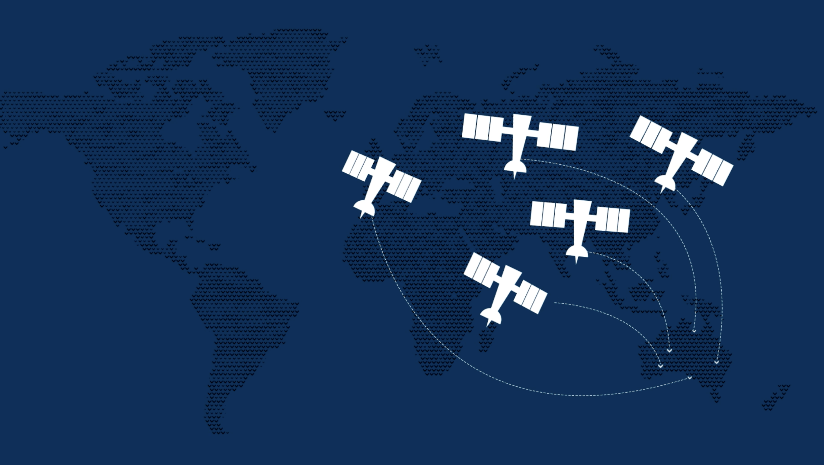
SouthPAN is a Satellite-Based Augmentation System (SBAS) in the Southern Hemisphere and provides improved positioning and navigation services in Australia, New Zealand and maritime regions.
Precise positioning from the network offers improved accuracy down to 10 cm. SouthPAN provides augmented and corrected satellite navigation signals directly from the satellite rather than through a mobile phone, providing accuracy that overcomes gaps in mobile internet and radio communications.
SouthPAN early Open Services has been live since September 2022, and aviation safety-of-life certified SouthPAN services are set to go live in 2028. Safety-of-life certified services are designed to support end users engaging in life risking operations, such as landing an aircraft at an airport.
OEMs of positioning and/or navigation service equipment are asked to share insights on the support of SouthPAN’s three services into chips, devices and equipment. In particular, the company is looking for OEM’s’ views on barriers and opportunities for support of the L1, dual frequency multi-constellation (DFMC) and precise point positioning (PPP) via SouthPAN services.
The information provided will assist Geoscience Australia (GA) and Toitū Te Whenua Land Information New Zealand (LINZ) to maximize SouthPAN ‘s full potential and benefits.
Click here to access the survey. Responses will be accepted until Sept. 30, 2023.
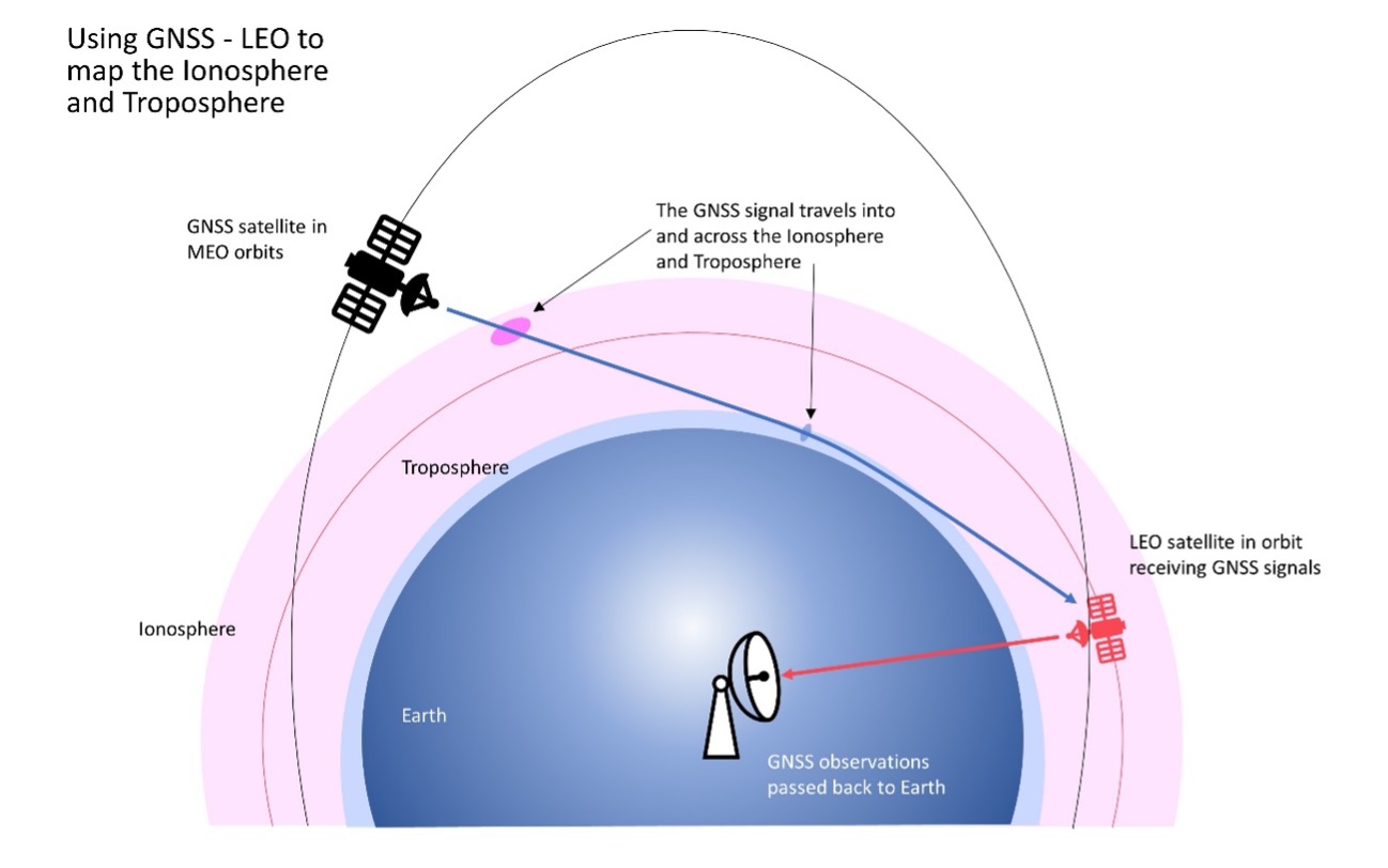
FrontierSI has signed a collaborative agreement with Geoscience Australia, Curtin University and the University of Newcastle to enhance Ginan with features specifically aimed at supporting low-Earth orbit (LEO) satellites as an important component of Geoscience Australia’s Positioning Australia program.
Ginan is Geoscience Australia’s GNSS analysis center software. It delivers a real-time positioning correction service through open-source software and additional positioning products to enable precise point positioning for Australian industry and users.
The design, development and deployment of LEO satellites has grown significantly over the last decade. The agreement with FrontierSI complements ongoing Ginan precise orbit determination (POD) development activities, focusing on the implementation of LEO satellite modeling and the orbit integrator/propagator capabilities needed to enable LEO GNSS data to be processed and high-precision LEO satellite trajectories estimated and predicted.
Such a capability will enable:
better monitoring of LEO satellites for station keeping, collision avoidance and end-of-life purposes
improved ionosphere and troposphere monitoring and modeling through the analysis of GNSS signal occultation, to provide data for weather prediction and precise positioning purposes.
SouthPAN provides accurate, reliable and instant positioning services across all of Australia and New Zealand’s land and maritime zones without the need for mobile phone or internet coverage. It will improve positioning from 5-10 meters, to as little as 10 centimeters — a 50-fold increase in accuracy.
The SouthPAN satellite-based augmentation system (SBAS) test-bed project took place between 2017 and 2019, demonstrating the value of SouthPAN to Australian and New Zealand economies and communities. Economic analysis indicates that it is more than $6.2 billion for Australia alone.
In February 2020, Geoscience Australia and Toitū Te Whenua Land Information New Zealand (LINZ) began a joint collaboration on SouthPAN under the Australia New Zealand Science, Research and Innovation Cooperation Agreement (ANZSRICA). A comprehensive procurement process followed, awarding an AUD$1.18 billion, 19-year contract on Sept. 16 to Lockheed Martin Australia.
“The SouthPAN project team will work with Lockheed Martin Australia to establish a network of Global Navigation Satellite System reference stations, a corrections processing facility and satellite uplink facilities that will enable accurate and reliable positioning signals to be transmitted from satellites to users,” said Madeleine King, Minister for Resources and Northern Australia. “The SouthPAN services will be fully operational across the two countries with safety-of-life certification from 2028.”
Benefits from SouthPAN
With early Open Services, Geoscience Australia and Toitū Te Whenua Land Information New Zealand enable industry access to SouthPAN. Early Open Services can immediately integrate with existing equipment or products, to create or enhance positioning service offerings to end-users.
Early Open Services will bring widespread benefits across agriculture, construction, resources and many other industries, paving the way for technological advancements in automation, including:
heavy vehicle automation, such as truck platooning, where vehicles can connect to each other as a group to transport goods
precision agriculture applications such as yield mapping, controlled traffic farming, inter-row seeding, precision spraying and livestock management
personnel safety on mine and construction sites, through smart geofencing technologies that accurately identify the locations of workers with key equipment, such as vehicles and heavy machinery.
SouthPAN is estimated to generate more than AUD$6 billion in benefits to the Australian economy over the next 30 years.
King said the new network will allow
mining companies to install more accurate collision avoidance systems on automated mining haul trucks
visually impaired citizens to navigate cities with pinpoint assistive technologies
light aircraft to land more safely in remote rural areas in all weather conditions, including essential services such as The Royal Flying Doctor Service.
The joint Australia-New Zealand initiative will be a game-changer for the economies of both nations, said Damien O’Connor, New Zealand minister for land information.
“This technology was originally developed to support aviation safety, but as technology has advanced, the applications have expanded,” O’Connor said. “It now has potential uses as varied as enabling accurate vehicle guidance for efficiencies in agriculture and horticulture management, tracking maritime shipments, and enabling navigation for drones and other unmanned vehicles.”
Early Open Services
SouthPAN will provide three early Open Services.
L1 SBAS Open Service. The L1 SBAS early Open Service will provide navigation messages on the L1 frequency (1,575.42 MHz), and allow users with a receiver that tracks GPS L1 C/A signals to improve their position accuracy to better than ≤3m in the horizontal and ≤4 m in the vertical (95% confidence interval).
DFMC SBAS Open Service. The Dual-Frequency Multi-Constellation SBAS early Open Service will provide navigation messages on the L5 frequency (1,176.45 MHz), and allow users — with a receiver that tracks GPS L1 C/A and L5 signals, and Galileo E1 and E5a signals — to improve their position accuracy to better than ≤1.5m in the horizontal and ≤2.5 m in the vertical (95% confidence interval).
PVS Open Service. The Precise Point Positioning (PPP) via SouthPAN (PVS) early Open Service will share the L5 frequency with the DFMC SBAS Open Service in the near future, before transitioning to a new navigation signal. PVS will allow users — with a receiver that tracks GPS L1 C/A and L5 signals and Galileo E1 and E5a signals, and is capable of processing the PVS messages — to improve their position accuracy better than ≤0.40 m in the horizontal and ≤0.55 m in the vertical (95% confidence interval) after convergence. Convergence will be better than 80 minutes during PVS early Open Services, and the user does not need to remain stationary during the convergence period.
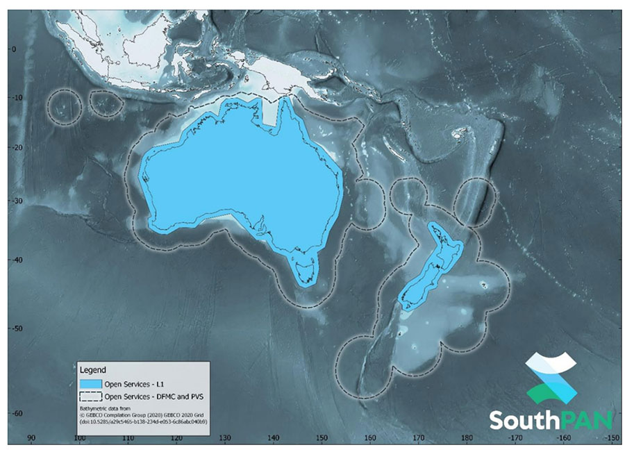
SouthPAN early Open Services coverage. OS-L1 covers mainland Australia and New Zealand. OS-DFMC and OS-PVS cover Exclusive Economic Zones in both countries. (Image: Geosciences Australia)
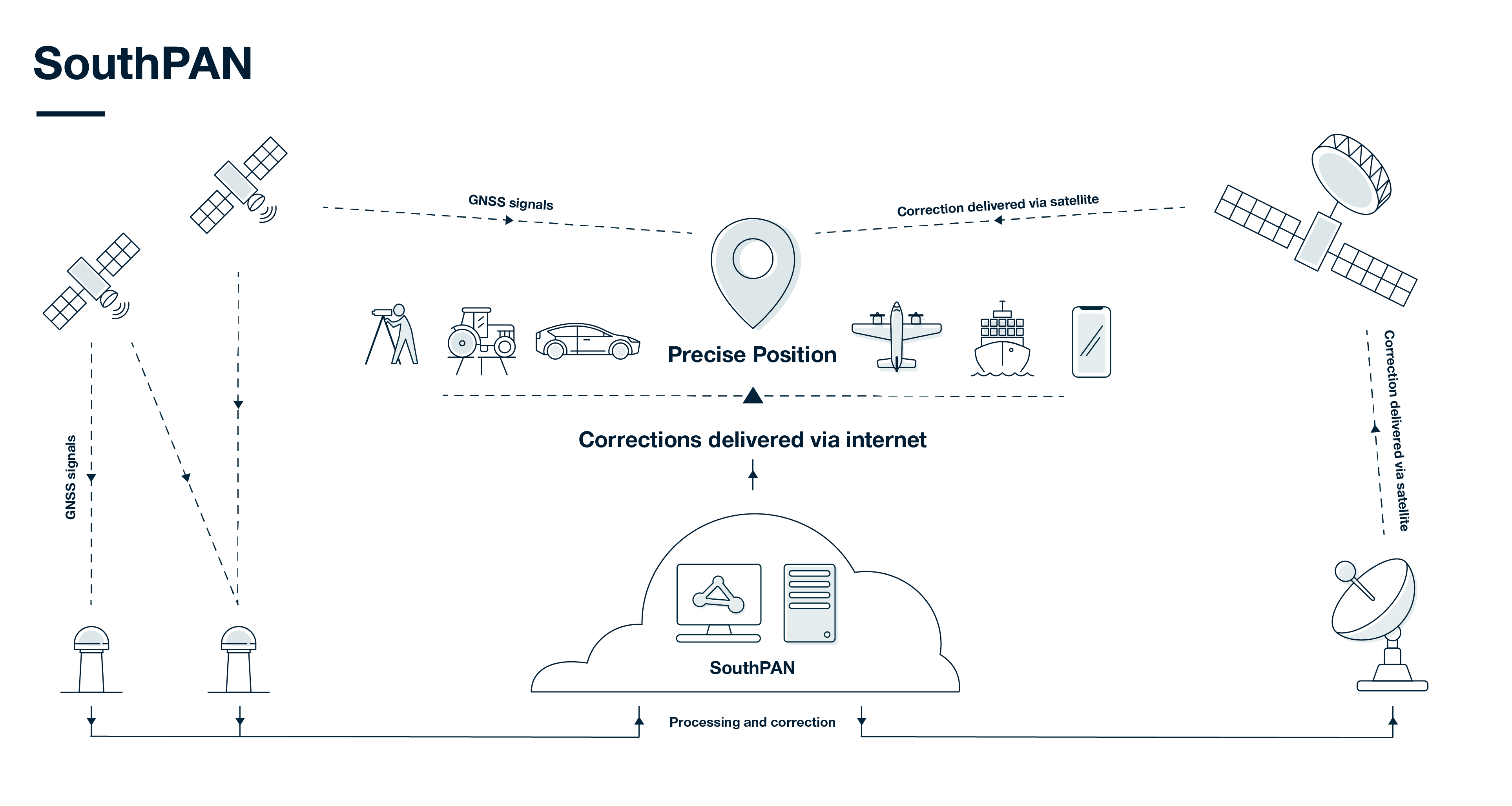
SouthPAN uses several distributed ground stations to monitor signals broadcast by GNSS satellites, and compares each station’s known location with position data from the satellites.
The GNSS signal data and measurement information is sent to correction processing facilities. The facilities aggregate the data from all ground stations, produce error corrections and status information about the GNSS satellites, and format the data in a standardized series of messages. These messages are sent to an uplink station, which transmits the data to a satellite in geostationary earth orbit. The data is broadcast to all precise positioning users, who combine SouthPAN’s data with their own observations of GNSS satellites.
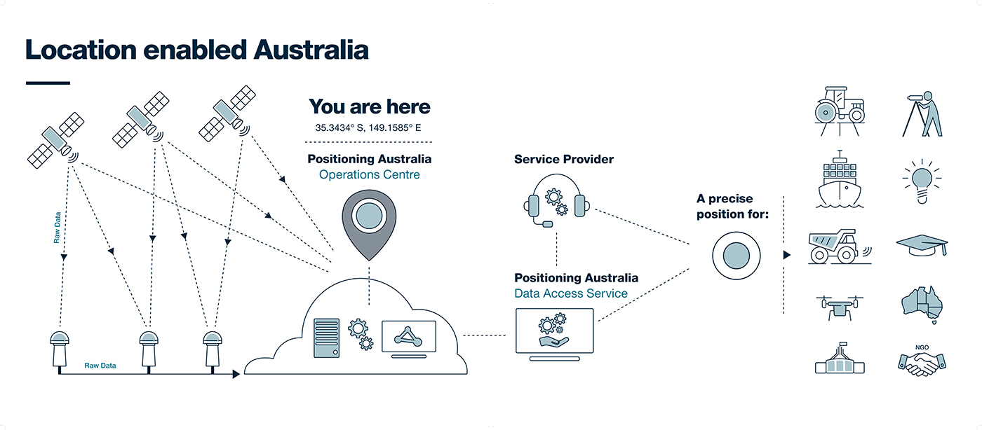
NPIC is key to a location-enabled Australia. (Image: Geoscience Australia)
Geoscience Australia is undertaking an assessment of the economic impact of the National Positioning Infrastructure Capability (NPIC) program.
The program provides free and open access to multi-GNSS observation streams from Australia’s network of continuously operating reference stations (CORS).
Users can connect to these data and product streams directly from Geoscience Australia or via a commercial positioning-service provider. The CORS network has been designed to support a national positioning capability that provides better than 5-cm accurate positioning solutions in areas with access to mobile-phone coverage (delivery via the internet).
Geoscience Australia has engaged ACIL Allen to conduct a web-based survey for stakeholders with interest in this program to assist with data gathering for the economic assessment.
The survey takes 15 to 20 minutes to complete. There is an additional optional component for service providers that may take an additional 15 minutes.
It can be completed in stages, if necessary, with a facility to save responses. It will remain open until June 28 (extended from May 25).
Questions can be directed to Alan Smart (project director) at 0404 822 312 or Nanumi Starke (ACIL Allen) at 0466 636 345.
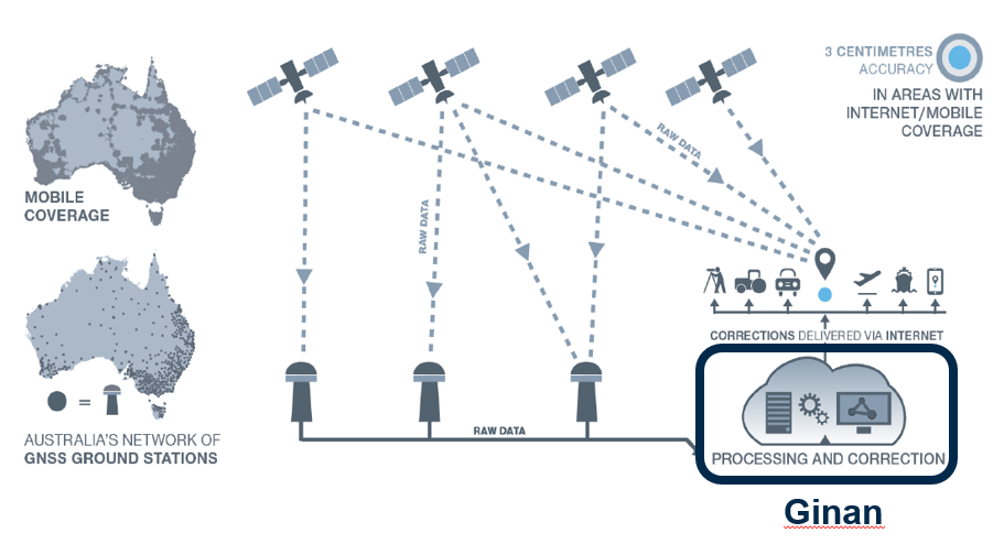
Geoscience Australia is developing open-source software — named Ginan — that will provide real-time corrections to positioning signals of all the GNSS constellations.
Once operational, Ginan will improve the accuracy of location data from 10 meters down to 3 to 5 centimeters for users with an internet and mobile connection. It will enable industry to provide reliable centimeter positioning to their customers, the agency said in a press release.
“Ginan is part of an exciting and innovative Australian Government program to enable precise positioning technology across the whole of the Australian continent,” said Martine Woolf, head of Geoscience Australia’s National Positioning Infrastructure Branch. “It will provide industry with the ability to use precise point positioning, bringing significant economic and social benefits to Australia.”
Examples of how this data could be used include reducing fertilizer and chemical spray waste in agriculture. It could also improve the operational efficiency of large mine sites through greater use of automation.
“Ginan will allow Australians to enjoy the benefits of precise positioning through the creation of new services and products, and in doing so, drive Australia’s economic growth,” Woolf said. “Our precise location data will inform of near real-time atmospheric conditions, which is already being used by the Bureau of Meteorology to assist with their weather predictions. It will also enable a greater understanding of movements in the Earth’s crust and provide insight into earthquakes, sea-level changes and the atmosphere.”
Ginan 1.0 will be publicly released in June 2022. An alpha version is now available on the Ginan GitHub repository, with a beta version planned for user testing from February 2022.
Ginan concept overview. This diagram illustrates how Australia’s network of GNSS ground station infrastructure streams GNSS satellite observations for Ginan to process and analyze, providing correction data to users through an internet connection. (Diagram: Geoscience Australia)
A thoughtful name
Ginan is named for a star that aided the First Australians as they navigated across the continent.
Woolf said the name of the software is a gift from the Wardaman people from the Northern Territory. Geoscience Australia sought permission to use the name Ginan as part of its commitment to respectfully engage and collaborate with Australia’s First Peoples.
“In the language of the Wardaman people, Ginan means ‘a red dilly-bag filled with songs of knowledge’. We like to think of this software as being similar to a dilly-bag full of knowledge because of the benefits it will unlock,” Woolf said. “Ginan is also the name of the fifth-brightest star in the Southern Cross. Just as the Southern Cross helped the First Australians to navigate this land, the positioning capability we are developing here at Geoscience Australia will enable us to know exactly where we are and where we are going.”
Wardaman Elder Diganbal Rosas said the dilly-bag was an important part of the Wardaman songline of the Katherine region. Songlines help to culturally and physically map land and seas through the transmission of traditional knowledge, cultural values, lore and wisdom across the landscapes. They are a living ancient memory code linking the environment, language and culture.
“Ginan [in our language] has all of the Wardaman knowledge regarding connection to country — all of the stars, the skies, the country, the people and the kinship. Everything we do is held in that dilly-bag, in that Ginan,” Rosas said. “The star teaches us many aspects of that spiritual connection to country, how it all began through those songlines, and how that story connects country to the stars. It is significant [that the Wardaman people have allowed Geoscience Australia to use this name] and I think it is a great opportunity for us to showcase our partnership.”
The Ginan initiative is part of Geoscience Australia’s Positioning Australia program, which is improving the accuracy of location-based data across the nation, bringing it from meters to centimeters.
“Seen & Heard” is a monthly feature of GPS World magazine, traveling the world to capture interesting and unusual news stories involving the GNSS/PNT industry.
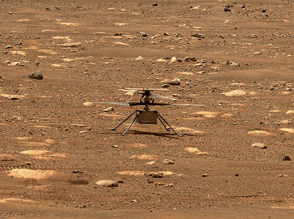
Integrity sits safely on Mars following an in-flight anomaly. (Photo: NASA)
PNT Issue Rocks Ingenuity
The Mars drone Ingenuity uses an inertial measurement unit (IMU) to track position, velocity and attitude. The IMU works with the rotorcraft’s navigation camera, which feeds images into the system. About 54 seconds into Ingenuity’s sixth flight on May 22, a glitch in the pipeline of images delivered by the camera caused Ingenuity to buck. The glitch caused a single image to be lost, resulting in all later navigation images being delivered with inaccurate timestamps. Ingenuity’s navigation system attempted to correct itself due to “phantom errors,” but the copter still managed to land within 16 feet (5 meters) of its target location. The Perseverance rover snapped an image of its flying companion the next day. The timing vulnerability is being addressed.
The versatility of the ZEB-Horizon device enabled the Deep Time team to map the complex and challenging environment. (Photo: GeoSLAM)
Measuring Deep Time and Space
Geospatial 3D mapping specialist GeoSLAM provided the technology to scan one of Europe’s largest caves as part of the Deep Time isolation study. For 40 days, 15 participants set up camp in the Lombrives cave in southwestern France with no clocks or sunlight, and zero contact with the outside world. Conducted by the Human Adaptation Institute, the experiment aimed to gain insight into human adaptability to isolation. For their first task, the “deeptimers” used the ZEB-Horizon to conduct a digital scan of the 3-km Lombrives cave — a system consisting of both narrow passages and expansive chambers up to 70 meters in height, formed more than 125 million years ago.
Photo: Nearmap
Avengers Assemble!
On June 4, Disney unveiled its Avengers Campus at its California Adventure park. Aerial image provider Nearmap, which has been flying over Disneyland and California Adventure twice a year since 2014, shared a bird’s-eye view of the park’s new area, which replaced “A Bug’s Life.” Nearmap also shared images comparing the crowd size in 2019 before COVID-19 to the reopening limit of 25% capacity in April.
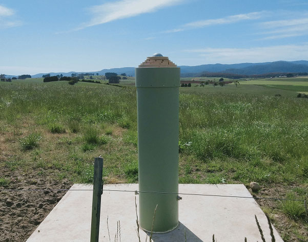
Photo: Geoscience Australia
Tasmania First
As part of the Positioning Australia program, Geoscience Australia is building new GNSS ground stations. The first new station was recently completed outside the town of Derby, Tasmania. This new station joins 10 existing stations in Tasmania, providing widely available GNSS-based precise positioning signals. To access the service, users can connect to a service provider offering a fully supported service with system integration; users with specialized equipment and the technical expertise to integrate GNSS positioning can connect directly to the station via Geoscience Australia’s GNSS Data Centre.
Geoscience Australia is seeking a prime contractor for a new satellite-based augmentation system (SBAS) that Australia and New Zealand have committed to implement.
The SBAS will improve position, navigation and timing (PNT) capabilities to end-users in Australia and New Zealand.
The system, which will be called the Southern Positioning Augmentation Network, will augment standard positioning capability provided by GPS and Galileo across all of Australia and New Zealand, with expected user applications in agriculture, construction, resources, utilities and other industries; with decimeter accuracy.
It will also support the aviation and road transport sectors, which have requirements for high-integrity positioning data with sub-meter level accuracy, Geoscience Australia said.
Full operational capability will require a number of satellite payloads in geostationary orbit needed to broadcast data to users. These may be hosted payloads rather than dedicated SBAS satellites, Geoscience Australia added.
This procurement process is administered by Geoscience Australia and is undertaken for the benefit of Geoscience Australia and its New Zealand counterpart, Land Information New Zealand.
“Seen & Heard” is a monthly feature of GPS World magazine, traveling the world to capture interesting and unusual news stories involving the GNSS/PNT industry.
Tethered drone
Spanish police used a tethered drone system for traffic monitoring, crowd control and surveillance of the UEFA Champions League Final, played June 1 at the Wanda Metropolitano stadium in Madrid. An Elistair tethered U06 Plus drone oversaw 67,000 fans in the stadium and 200,000 in nearby streets. Use of the drone was in response to a heightened terrorist threat level in Spain, making it part of the largest security operation for any sporting event in the Spanish capital. Continuously supplied with power, the drone maintained its position at 50 meters high for 8 hours.
CYGNSS satellite launch. (Artist’s concept/NASA)
Tricky Signals
NASA’s eight CYGNSS (Cyclone Global Navigation Satellite System) microsatellites collect radio signals from GPS beacons to characterize hurricanes. A month after launch in December 2016, the CYGNSS team noticed the signals were wavering when the U.S. began to boost the radio power on 10 GPS satellites as they passed over northern Syria. The swings don’t interfere with other scientific uses of GPS, but for CYGNSS the measurements of high winds varied by 5 meters a second or more — the difference between a category-2 and category-3 hurricane. After two years of work, the CYGNSS team has compensated by repurposing a secondary antenna on the satellites to measure GPS signal strength.
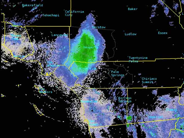
The ladybug blob tracked by Doppler radar. (Image: National Weather Service)
Ladybug, ladybug, fly away home
In this case, California. In June, a millions-strong swarm of ladybugs showed up on radar as a weather event when the insects took to the sky to hunt for aphids. One explanation for the unusual swarm is that a large population of ladybugs had been spread out in a mountainous area, and rising temperatures triggered their mass migration to valleys where they might find an abundance of aphids to eat.
New Zealand joins Aussies on SBAS
Land Information New Zealand (LINZ) will work with Australian counterpart Geoscience Australia to investigate ways to deliver a regional satellite-based augmentation system (SBAS) to significantly improve GPS accuracy. The proposed SBAS will support emergency helicopter crews, providing pilots with accurate vertical guidance for landing, enabling them to reach people faster in difficult terrain and bad weather. The SBAS will also improve the safety of self-driving cars. The new system will improve accuracy to less than a meter, and in some devices to 10 centimeters.