According to organizers, the GEO Business show connects the data holders and processors with the people who benefit from the applications and insight which geospatial information provides.
“We appreciate how important GEO Business is for you, your business and the whole profession,” GEO Business said in a statement. “And we’re very sorry to disappoint you and the thousands of others who were planning on visiting this year. However, the safety of our visitors, speakers and exhibitors remains our priority.”
The 2021 event will now take place alongside Digital Construction Week, an event dedicated to digital construction, engineering, design, manufacturing and operation.
“Whilst both will remain separate shows, they will in effect create one much larger technology event for the sector,” GEO Business added.
One industry important to the world’s fight and recovery from the COVID-19 pandemic is geospatial analytics. In response, the World Geospatial Industry Council (WGIC) has created an information hub for COVID-19 information.
“These are very uniquely challenging times for our industry. At the same time, our industry has stood up to assist the world, especially the key decision-makers and frontline workers to understand the scenarios on the ground,” said Harsha Vardhan, WGIC associate director. “Spatial analytics-based decision making has come to the forefront during these times.”
Governments are using location tracking in combination with personal data to track and combat COVID-19, and the use of location technology in conjunction with personal data is of high relevance and usage, Vardhan said. “This scenario brings before us the aspects of data privacy, data protection, and the role of geospatial information.”
In March, WGIC published a report titled “Geospatial Information and Privacy: Policy Perspectives and Imperatives for the Geospatial Industry.” Vardhan said the report is even more significant now. WGIC is hosting a webinar on the report on May 14 at 11 a.m. ET.
GEO Business 2020 organizer Diversified Communications U.K. has decided to change both the venue and date for the event. The event will now be taking place Sept. 24-25 at ExCeL London.
According to show organizers, GEO Business is the U.K.’s largest geospatial event designed for those involved in the gathering, storing, processing and delivering of geospatial information.
“GEO Business is one of the most important business events for the geospatial industry,” said Carsten Holm, managing director of Diversified Communications U.K. “A lot of companies rely on it to meet new and current customers, so this decision has not been taken lightly. However, the response to the outbreak is unprecedented and I think many would agree that it is not a climate in which we want to hold the show. The success, as well as the safety of our exhibitors and visitors, have always been our priority and this continues to be the case. We have been overwhelmed with support on the decision to move the show to new dates, including from our show partners AGI, CICES, TSA, ICE and RICS.”
Portfolio Director Caroline Hobden also addressed the location change.
“After six successful years at the Business Design Centre, we have taken the decision to move GEO Business to the new venue ExCeL London,” she said. “As the show has continued to grow, we have been looking to move to an alternative venue in 2021. However, the current situation presented an opportunity to make the move ahead of plan this year. Best of all, this new tenancy keeps the show in the heart of London.”
Geographic information systems and augmented reality are a part of our daily lives, so much so, we hardly notice them. GPS World columnist William Tewelow explores how these technologies will continue to change our lives.
Geographical information systems (GIS) and augmented reality (AR) have become a part of our daily lives, so much so that we hardly notice them. Those of us in the profession make our living by them; millions, soon billions more in the consumer world benefit from them without even realizing they are there.
The world is filled with data. Using AR, that data can be draped in front of us in a tapestry based upon our individual needs and interests. Applications multiply daily.Many physical tools now in use will become virtual tools; workspaces, living spaces and the commutes between them (if they even exist at all) will change almost unrecognizably.
The world is poised to become an amazing and magical place.
Before we jump whole hog into the future — something that AR assuredly enables us to do — a glance back at the past can fill out our understanding of these great tools, GIS and AR — each great in and of its own, but virtually invincible when combined. Come with me down the corridors of history . . .
When Great Swords Clash
World War II was a fight against global domination — mankind’s greatest struggle for survival. Tyranny or freedom hung in the balance. The greatest minds raced to harness the powers of nature and science, plying them towards victory. This culminated in the invention of the ultimate weapon, The Great Sword, able to lay waste entire cities and ending the Second Great War in 1945, the year the world returned to peace. Freedom reclaimed the throne, euphoria spread — but the celebration was short-lived.
Kazakhstan. (Map: CIA archives)
In the summer of 1949, the world split in half. In the United States, families gathered around the radio for comedy and drama before putting the children to bed, but on the other side of the world, deep in the center of a faraway, unknown land, on a cool Monday morning as the sun lazily rose over a barren terrain, a second blazing sun rose into the sky. The Soviet Union unsheathed and brandished its own Great Sword, making remote Kazakhstan the center of the world in that brief moment. The sound of the bomb was heard in Washington, D.C., and phones throughout the city rang into the night. Russian spies had stolen America’s atomic secrets. Nuclear annihilation was a reality. The Cold War had begun.
The threat of nuclear weapons in Soviet hands was too great a risk. The United States had to know the extent of the threat. Satellites did not yet exist. Airplanes had limited capabilities. The only way to know what was going on inside the Iron Curtain was intelligence assets on the ground, but the Soviets controlled the ground.
Play Your Aces High
Penetrating the skies over the Soviet Union became the top priority. In 1954 Operation AQUATONE began to build the first U-2 spy plane to fly at an altitude above the limits of enemy air defenses.
U-2 spy plane. (Photo: U.S. Air Force)
But Operation Aquatone was only half the challenge. In the vacuum-tube and wet-film era, building a camera small enough to fit on the U-2 and able to take pictures at the required resolution from so high an altitude was needed. These two efforts took place simultaneously on opposite sides of the country. Operation Aquatone took place in the Mojave Desert at what is now famously known as Area 51, and Operation HTAUTOMAT, the photogrammetry and photo-interpreters effort took place in Boston, Massachusetts and Washington, D.C. Both programs came together successfully in 1956 and the U-2 made its first reconnaissance flight over Eastern Europe.
Almost immediately, the demand for photo intelligence skyrocketed. In 1957 the Soviets launched Sputnik, the first manmade satellite to circle the Earth. Sputnik’s beeps could be understood in every language. Each of the beeps said, I am here above you no matter where on Earth you are, ultimately asking the question, What if I was a nuclear warhead? This elevated the need to surveil Khrushchev’s nuclear weapons capabilities. The Space Race had begun.
Five of a Kind Beats a Straight Flush
Satellite imagery from Discoverer XIV. (Photo: National Reconnaissance Office)
The U-2 flew unimpeded anywhere in the world for four years. But that ended in May 1960 when Captain Gary Powers, the U-2 pilot was shot down 300 miles east of Moscow. In August that same year the world sat transfixed watching the Soviet show trial of the captured U-2 pilot. President Eisenhower took full advantage of the diversion to launch the Discoverer XIV satellite, the first fully operational reconnaissance satellite under the CORONA program. A day later the satellite dropped its first payload, a 20-pound capsule of film. It was retrieved over the Pacific by a C-119 Flying Boxcar. It contained 1.6 million square miles of Soviet territory, providing more imagery than the entire U-2 program combined.
The Photo Interpreters Division (PID) was established to deal with the huge volume of imagery. It was renamed the National Photographic Interpretation Center (NPIC). NPIC used an ALWAC III computer, advanced for its time, but it ran on vacuum tubes and punch cards. It could calculate size and distance in imagery. Over 12 years, the CORONA program collected 2.1 million feet of film, but its processing could not keep pace with the flood of incoming imagery.
Development of the TX-2 computer in 1959 altered this picture, but two problems persisted. First, computers’ limitations prevented an analyst from working directly with imagery. Additionally, finding something noteworthy in an image was only half the problem; the other half was piecing together where on a map the feature belonged. Interior maps of the Soviet Union were vast, featureless, and not well developed.
Let Your Wild Horses Run
MIT graduate student Ivan Southerland solved the first problem, inventing a graphical user interface (GUI) on a TX-2 computer for his doctoral thesis, thereby revolutionizing computer graphics, computer-generated imagery (CGI), and computer-aided design (CAD). Southerland soon found himself heading the government’s Advanced Research Projects Agency (ARPA) to further develop the GUI. His innovations greatly advanced programs such as NPIC, allowing photo-interpreters to work directly with imagery displayed on a computer screen.
A visionary, Southerland saw computer-generated synthetic worlds merging man and computer; he created what became known as the Sword of Damocles, the first augmented-reality (AR) headset. It was so heavy it had to be suspended from the ceiling on cables in a big swindling contraption, hence its name. The Sword of Damocles evolved into the helmet-mounted display that military pilots use today, and became the foundation for development of Google Glass, Oculus Rift, Microsoft’s HoloLens and Meta.
Several years later, Southerland went to Harvard as an associate professor, continuing his work with computer graphics. During his tenure, a student working in Southerland’s computer graphics and spatial analysis lab saw the potential of combining CGI and CAD with his own knowledge of environmental science and landscape architecture. That student was Jack Dangermond, who created Esri in 1969.
Solitaire Takes Two
Thanks to Jack Dangermond and Ivan Southerland, GIS and AR are a part of our daily lives, so much so, we hardly notice them. They have changed how we watch sports. Long gone are the days of John Madden with an electronic pen scribbling out plays with great wit but terrible penmanship. Now, football shows a red scrimmage line on every play and the first down line in blue. We wonder why they have to take out the chains to measure the down because we can clearly see it on screen, but on the field they don’t have the luxury of AR.
Game highlights show a player encircled in a column of light for the commentator’s in-depth coverage. Live imagery projects the commentator into the image of the replay as if he or she is on the field in the midst of the action. Further back, advertisements appear on sideboards of the stadium stands, but only to television viewers. To those physically present at the game, the advertisements do not exist. You can observe this during an instant replay. Take notice of the sideboards during the game and then look at them during the replay. It is a blank, green board — same with baseball.
AR makes it easier to watch a hockey puck with a blurred red tail as it zips across the ice. In golf, a light green glow surrounds the ball on long drives enhancing our entertainment experience.
AR works by knowing where the observer is and where the observer is looking and integrating that information with line-of-sight data. Smartphones provide that capability, ushering in the age of personal AR apps. My personal favorite is FlightAware to track airplanes by aiming a phone’s viewfinder at the aircraft to know the altitude, speed and other information.
For identifying celestial objects, SkyMap helps find a planet, star or constellation. Real-world AR gaming is upon us, the most famous being PokemonGo. A more interesting game is Ingress, which uses real-world landmarks (featured in Nov 2017 article, Game-based learning improves training, engagement). MapBox has a location-based AR platform to support gaming.
Figments of Imagination
Museums consider AR the next frontier. Imagine putting on a pair of AR glasses and seeing things come alive. Stand on the Moon or Mars, or fly in the cockpit of an X-1B, the first supersonic aircraft. Go to an art museum and step into Van Gogh’s painting, Starry Night; the world around you becomes iridescent, globular, and thickly swirled in bold colors. (See Alex Mayhew’s exhibit, ReBlink at the Art Gallery of Ontario).
Walk through a park and statues become human, blink their eyes and speak to you. Dinosaurs, typically static monoliths, roar to life. It is no longer imagination. The Smithsonian’s National Museum of Natural History has an exhibit using your phone to do that very thing. It might seem as if AR is the future, but it is also revealing the past. Archaeology is using AR to see ancient cities as they once were. Those experiences enhance our learning, but what about more practical daily uses?
The world is filled with data. Using AR, that data can be draped in front of us in a tapestry based upon our individual needs and interests. That data can be passive, like location information such as place names appearing in the field of view as icons helping guide you where to go. No more looking down at a smartphone trying to figure out which way to walk. A light blue transparent dotted walking path will lie before you, leading to the icon above the door of the place you are going. Active AR, on the other hand, try to engage you, such as advertisements. A box will seemingly glitter and glow mesmerizing a person into buying it. Another will have tiny figures dancing on it enticing a customer. Look at a menu and the items will appear real for you to inspect before you order. The world is about to become an amazing and magical place.
How about workstations? They’ll be a thing of the past. No need for a monitor in the physical sense. It can be created as large as needed and placed anywhere as well a virtual keyboard. Interface directly and more naturally with the world around you.
Many of the physical tools now in use will become virtual tools, such as a measuring tape, a ruler, a laser level, a GPS receiver, and even pen and paper to some degree. They will just be apps in your smartglasses, call it AR-ware — mere programs, what we used to call figments of our imagination. Grab an AR-ware pen and paper and the handwriting appears perfectly normal but it is just digital text: save it, email it, or print it. Make up new tools or download tools as we do apps on our smartphones. Imagination will be the limiting factor.
Upload CAD blueprints and schematics into an AR generator and look around the house with x-ray vision and see inside or through walls and floors. A plumber can see pipes in the wall, their sizes and what they are made of. An electrician can see the wiring, frames, and pass-through holes. An insurance adjuster can look at damage, take notes in AR then pass everything along to the company who passes it on to the contractor.
Take that same scenario and scale it up to the size of a city. AR allows companies to see the vast network of utilities and assets hidden in the subsurface. The water company can know exactly where its water and sewer lines are located, as well as what other utilities are nearby? Contractors can see exactly where to dig, and just as importantly, where not to dig. INTUS Inc. is a leader in the rapidly growing field of subsurface assets using GIS and AR technology. INTUS’s CEO, Dimitris Agouridis, calls it “intelligent infrastructure.” He goes on to say the technology supports the Call Before You Dig law, and helps avoid costly mistakes that can destroy property, the environment and people’s lives. It saves time, money and resources, and reduces outages due to repairs that inconvenience residents. It also increases a city’s resiliency after a disaster.
The fascinating reality ahead of us is mere moments away measured in months and years. We will walk into museums and experience them in new ways. We will stand in an ancient place and see it reconstructed to its former glory from eons ago. We will work using smartglasses in ways we can only begin to imagine. Road crews will do precision repairs. One day, I will write this article, but not on a laptop, and instead sitting in a world part real, part virtual tied together by a perfect symmetry of place and time. A magical future awaits us created by merging GIS and AR.
My next column, coming in March, will go further into augmented reality and other emerging technologies that rely upon geographic information to build the next generation of intelligent infrastructure.
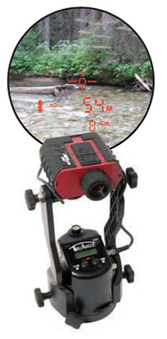
Using lasers in conjunction with GPS can collect richer data, faster, and streamline survey and mapping projects across many disciplines that draw on mapping and geospatial information systems.
To learn more about the exact processes involved in Integrating a professional measurement and mapping laser to your GIS toolbox, both saving time and enabling collection of additional attribute data attend GPS World’s free webinar on Thursday, Aug. 16: LaserGIS: Your Gateway to Collect More GIS Data in Less Time.
The webinar will be available for download 24 hours after broadcast time, for those unable to attend live.
The applicable fields for this enabling technology include surveying, construction, ecosystem management, watershed analysis, geological mapping, environmental impact assessments and more.
Photo: Laser Technology Inc.
A natural resources ecosystem manager said, “I map areas that are either impossible to occupy or simply can’t be disturbed, so using laser-based reflectorless measurement technology is ideal for wildlife habitat research. When performing soil surveys, I can easily calculate the grade of a slope by using the missing line routine. I even used the Laser Technology TruPulse once to track the progress of a wildfire. This technology is a must-have for our crews because it’s highly portable and produces reliable data.”
A land conservation specialist performing watershed analysis added, “Stream channel surveying tools have come a long way since I graduated college. I’m now able to mark a stream’s course, calculate the gradient and measure the width of the riparian zone, all with a simple point-and-shoot TruPulse laser. For wetland delineation projects, being able to shoot directly to the bank saves a huge amount of time and keeps me and my crew as dry as possible.”
A geologist performing mapping as part of his work routine said, “I need to accurately track geological structures in mines and outcrops, and would really struggle with collecting measurements if it wasn’t for my TruPulse 360. With the laser, I can get a measurement to any type of surface and don’t have to stand in dangerous areas, so I can be extremely productive and safe. When I have to verify the volume of our biomass stockpile, I just integrate my laser with MapSmart and get reliable calculations in minutes, right in the field.”
Finally, an archaeologist performing an environmental impact assessment stated, “Conserving archaeology sites is just as important as researching and analyzing them. Integrating the TruPulse with GPS allows me to make better planning decisions with all types of resource considerations without compromising data integrity or delicate areas. The TruPulse’s onboard solutions for height and 3D missing line make my job so much easier and far more productive than conventional measurement tools.”
GITA (the Geospatial Information & Technology Association) held its Annual Conference 29 in Tampa, Florida, April 23-26. GITA President Susan Ancel called the conference, which included a poster session and a job fair for the first time, “the highlight of the year for the association.”
This year’s theme — “No Barriers: Connected. Responsive. Prepared.” — was explored in an interoperability demonstration that captivated the Opening Session audience. Executive Director Bob Samborski told the attendees, “what you’re about to see this afternoon is what we envision GECCo would look like in many respects,” referring to GITA’s Geospatially Enabling Community Collaboration initiative.
The premise for the demonstration — a scenario about Tampa’s bid to host the 2012 Olympic Games — may have been fictional, but the applications, data, and interoperability were real. To prepare a proposal that included analyses of emergency response, infrastructure, transportation, and other relevant capabilities, the would-be host city had to pull information from a host of dispersed datasets in a variety of formats. Tampa officials and geospatial vendors who collaborated in the live presentation succeeded at their task, proving that open standards-based software, data, and services can overcome data-sharing obstacles.
During the opening session, GITA also honored winners of the 2006 Excellence, Innovator, and Distinguished Service awards, as well as what Samborski called “the highest award the association can bestow” — the Geospatial Industry Lifetime Achievement award, which went to C. Warren Ferguson. In regard to his long career in the industry, Ferguson said, “understanding the value of location, and being able to communicate it,
is perhaps my greatest contribution to the geospatial community.”
The theme of “No Barriers” carried through to the show floor, where improved data sharing, technology integration, and collaboration reigned. TerraGo Technologies has added a capability to its GeoPDF file format that enables full round-tripping of markups and redlines, transforming a viewing tool into a collaboration tool. Once GeoPDFs are created with TerraGo’s MAP2PDF for GIS, then geo-enabled for commenting with TerraGo’s MAP2PDF for Geo-Enabling software and Adobe Acrobat Professional, any user with Adobe Reader and TerraGo’s Geo-Enabled GeoPDF Toolbar can export shapefiles for round-tripping back to a GIS.
CH2M HILL demonstrated several solutions that combine tracking technologies with Google Earth. The company’s GE Tracker plots the location of GPS-enabled devices (such as cell phones) in real time through the Google Earth interface. Example applications include recording the time a delivery driver spends at a particular location, routing the most conveniently located courier to a job, and keeping tabs on a child’s trip to a movie theater. As Vice-President of C&IS (Communications & Information Solutions) Nigel Nugent said, everyone wants to know “where’s my stuff, and what’s happening to it?”
LizardTech announced its Spatial Express application, which enables users to store raster imagery in an Oracle database in its native MrSID and JPEG 2000 formats. Spatial Express uses Oracle’s GeoRaster application program interface and provides raster imagery compression of up to 95 percent, with no visible loss of quality. Selective decoding reduces the time needed to view imagery by decompressing only the relevant region of an image.
FCSI unveiled IT3D for FME, a plug-in for Safe Software’s Feature Manipulation Engine (FME) that translates GIS data from more than 100 formats into high-resolution three-dimensional (3D) visualizations. IT3D includes 3D conversion software, a 3D viewer, a library of 3D models and textures, and communications interface software for GIS-to-viewer interaction. Visibility of individual features can be toggled on and off, meaning that a user can hide the surface of the ground to expose the locations of buried pipelines or cables.
Outside the exhibit hall, the use of GIS in managing underground utilities data was the focus of educational sessions about locating buried lines and populating “call before you dig” services with up-to-date information. Rather than using outdated paper maps or relying on memory, utilities and other organizations are now turning to a combination of GPS, GIS, and facility location technologies to create accurate maps of underground lines. Other sessions explored the use of GIS in such areas as work and asset management, emergency response, system integration, and planning, design, and engineering.
Throughout the event, the dynamic nature of the geospatial industry and its technology was apparent. Intergraph’s Vice-President and Chief Technology Officer Peter Batty discussed the changes brought about by rapidly evolving technology. Thanks to the increasing accuracy and availability of location-tracking technologies, he said, geospatial technologies once primarily limited to documentation and planning are now being used for dynamically scheduling and assigning work, and a host of other real-time applications.
The 30th Annual Conference and Exhibition, titled “Mission Possible,” will be held in San Antonio, Texas, March 4-7, 2007. For more information, visit www.gita.org.