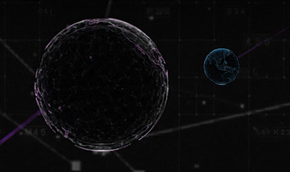
CGI, one of the largest independent IT and business consulting services firms in the world, has entered an alliance partnership agreement with Vantor, provider of unified spatial intelligence from space to ground. The companies have signed a Letter of Intent outlining their plans to collaborate on developing next-generation solutions that combine CGI’s advanced artificial intelligence (AI), edge computing and visual analytics expertise with Vantor’s Spatial Intelligence platform Tensorglobe and its Raptor product for navigation and geolocation in GNSS-denied environments.
The collaboration will enhance mission effectiveness and real-time situational awareness across defense, national security and environmental domains. CGI and Vantor will deliver integrated intelligence solutions that combine AI, spatial intelligence, space-based sensing and digital platforms, enabling faster, more informed decision-making in increasingly complex operational environments.
The partnership reflects growing demand for interoperable, sovereign and commercial solutions that strengthen operational resilience in a changing geopolitical and environmental landscape.
“We are bringing together complementary strengths in AI-driven analytics and secure, scalable access to satellite data through this collaboration with Vantor. As governments and industry organisations look to improve resilience and responsiveness, integrating near-real-time space-based intelligence into digital command and control networks will be key to achieving decision advantage,” said John Hanley, Secure Mission Critical Solutions, CGI.
“Collaborating with CGI allows us to extend the reach of Vantor’s technology and apply it to new use cases that demand both agility and precision. Our combined capabilities will help defense and civil government customers derive actionable intelligence faster and more securely, supporting safer operations and smarter use of global data assets,” said Anders Linder, general manager, Vantor International.
The companies seek to develop solutions that fuse CGI Machine Vision and CGI SignalSense platforms with Vantor’s Tensorglobe services to enhance high-precision geo-positioning and imagery analytics. Integration with Vantor’s Raptor products will support users operating in GNSS denied or degraded environments to navigate and position coordinates. The collaboration will pursue opportunities across the UK, Europe, and allied markets for AI-enabled edge computing and space-based situational awareness capabilities.
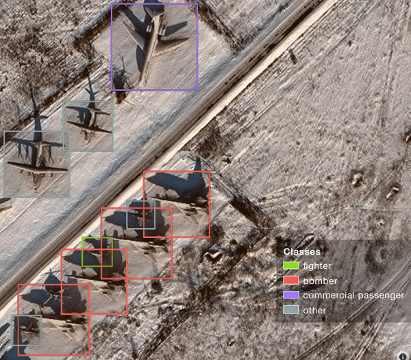
A sample image from Orbital Insights showing classes of military aircraft at a base. (Image: Orbital Insights)
Orbital Insight will integrate Satellogic’s high-resolution multispectral imagery, hyperspectral imagery, and full-motion video into its GEOINT platform
Geospatial intelligence company Orbital Insight has partnered with Satellogic, a leader in sub-meter resolution satellite imagery collection. The partnership will integrate Satellogic’s high-frequency, high-resolution collections of satellite imagery and full-motion video into Orbital Insight’s platform and offer customers better access to high-quality data, improve the revisit rate, and reduce the cost of running analytics.
Satellogic designs, manufactures and operates its own constellation of Earth observation satellites. It has 22 operational satellites in low Earth orbit with plans to launch up to 12 additional satellites by the end of the year. The company aims to expand its constellation to more than 200 satellites by 2025 for daily global coverage of the entire surface of the Earth.
Orbital Insight’s flagship GO platform combines information from the world’s sensors to analyze economic, societal and environmental trends at scale and support activity-based intelligence. Commercial businesses and government agencies use the self-service platform to synthesize answers to critical questions about what’s happening on and to Earth.
Satellogic will provide high-resolution Earth observation data at vastly superior unit economics. This will allow Orbital Insight customers to increase the number of daily revisits on points of interest, see a more granular picture and get deep insights that were not possible before.
“Advanced geospatial analytics require access to high-resolution, high-frequency satellite imagery and simple tasking,” said Kevin O’Brien, CEO, Orbital Insight. “Satellogic is disrupting the industry with a cost-effective, vertically integrated business model. This approach aligns well with our philosophy of making geospatial intelligence efficient, intuitive, and simple so that our customers can get timely insights, make critical decisions, and respond faster.”
“Our mission is to enable greater access to critical Earth observation data. Working with Orbital Insight extends our reach, making our data available to more customers across diverse fields who need to know how the world around them is changing,” said Emiliano Kargieman, CEO and co-founder of Satellogic.
Up to five-year contract follows a successful pilot program that demonstrated the value of commercial RF geospatial intelligence
HawkEye 360 has been awarded a contract by the National Geospatial-Intelligence Agency (NGA) to help the agency discover, characterize and map activities that emit energy in the radio frequency (RF) bands of the electromagnetic spectrum.
HawkEye 360 specializes in RF data and analytics from space-based satellites.
HawkEye 360 will provide NGA the means to develop global datasets, enabling users to discover and monitor a broad range of RF activity across large geographic areas.
The $10 million one-year contract includes an option for four more years. It will support users throughout the NGA enterprise, including the combatant commands and other mission partners.
HawkEye 360’s data will support a variety of analytics missions for NGA, including military activity and the trafficking of military, nefarious, non-state and transnational criminal (or illicit) activity. The company’s growing constellation of satellites will provide insight into developing events in a timely manner, and the company will work collaboratively with NGA on an ongoing basis to effectively meet the agency’s mission needs.
“We’re pleased to be moving from the pilot into an NGA long-term operational contract, which showcases the value of unclassified, shareable commercial RF insights,” said HawkEye 360 CEO John Serafini.
“This program is an excellent example of agile acquisition rapidly delivering high-impact GEOINT to the warfighter,” said Alex Fox, the company’s executive vice president for business development, sales and marketing.
NGA leveraged a National Reconnaissance Office commercial integration study contract with HawkEye 360 in September 2020 to execute a test and evaluation contract with the company.
NGA then issued a competitive RFP in March 2021 and awarded the contract in July 2021. “We are excited to continue working with NGA to address current mission requirements and expand the RF GEOINT tradecraft to address an even larger set of mission requirements, much like NGA has done with their pioneering use of commercial imagery,” Fox said.
HawkEye 360 operates a constellation of nine RF-monitoring satellites. Twenty-one additional satellites are fully funded and scheduled for launch in 2021 and 2022. Once complete, this baseline constellation of 30 satellites will provide collection revisits as frequently as every 20 minutes.
Following the establishment of the baseline constellation, HawkEye 360 plans to launch a second-generation constellation of 30 additional satellites by 2025 to satisfy projected capacity and operational requirements.
The company’s RF data and analytics produce actionable insights for national, tactical and homeland security operations, maritime domain awareness, environmental protection and a growing number of new defense and commercial applications.
“Crime is common. Logic is rare. Therefore, it is upon the logic rather than upon the crime that you should dwell.”
“Data! Data! Data!” He cried impatiently. “I can’t make bricks without clay.”
— Sherlock Holmes, “The Adventure of the Copper Beeches,” Sir Arthur Conan Doyle
Watson is to Holmes what information is to intelligence. Watson could listen to the client story, observe the situation, and recite to Holmes all the relevant facts, but he lacked the ability to string together the seemingly random pieces of information into a coherent chain of events leading to the correct hypothesis. A computer can become a Watson, but it takes a human to be Sherlock; however, a human misguided by cognitive biases will end up as Inspector Lestrade, always coming to the wrong conclusion.
When it comes to data, the analogy of drinking from a fire hose is an understatement. Consider that a digital image can be terabytes in size and every day millions of images are taken. Facebook generates 4 petabytes of data daily, and each day there are 500 million tweets and 306 billion emails. Additionally, there are 20 billion connected devices. Combined, the world creates 2.5 quintillion bytes of data every day. If a grain of sand represents a byte of data, then every three days more data is created than there are grains of sand on the Earth, and it is only increasing.
Somewhere in all that data are signals. Real-time threat intelligence systems are looking for those signals before the next huge event occurs. It is a high-stakes hunt for Leviathan, except that Leviathan is only a packet of sand traveling at lightspeed through a cloud obscured by dust.
Nellis Air Force Base takes part in Red Flag 15-2 at its Combined Operations Center in 2015. (Photo: Senior Airman Thomas Spangler/U.S. Air Force.)
Interpreting a Signal
The massive volume, variety and velocity of continuously flowing data far surpasses the ability of humans to process. It exceeds the bandwidth most systems can handle. And it quickly overwhelms the capacity to store, manage and act on the information in a timely and cost-effective manner. Resources are not infinite. The best model to handle an overwhelming amount of data is the human brain. Humans are biological sensors. Every moment of every second of our lives, our bodies are receiving an endless stream of stimuli from internal and external sources. Most of this stimuli registers at an unconscious level, and as long as the stimuli is normal and expected, it goes unnoticed by the conscious mind. If, however, any discomfort is experienced, the conscious mind is notified. Then that becomes the focus until normalized. Externally, the same applies to computer data systems. Normal conditions are ignored, but if there is something unusual, such as a loud constant noise, or a colder than normal temperature, it draws all the processing attention.
In the realm of intelligence that is basically how things function. Algorithms are written to learn the normal patterns of life and to identify specific events, words, names, etc. As long as data is within normal parameters, it gets little attention, but as soon as an anomaly exceeds a threshold or something triggers the algorithm, it will immediately be brought to the attention of the intel center. An example can be viewed on the Global Incident Map dashboard. I encourage you to sign up for a free 72-hour membership. If you want to see what real news looks like, this would be a sampling. The number of real incidents that happen across the country and around the world that you never hear about, many of them hair-raising and all of them open source, add to the few stories the media has been able to tell about cyber attacks. Scroll down the page. There are many filters, but I recommend turning them all off to see the full extent of information. Clicking on an incident will drill down into the actual source so you can read about it more thoroughly.
Below is the U.S. Army’s real-time critical incident dashboard called the Joint Analytic Real-Time Virtual Information Sharing System (JARVISS). It tracks and monitors activity near U.S. Army installations and standalone assets of interest around the world.
Another dashboard for cyberattacks is Check Point, which shows just how aggressive cyberthreats are throughout world. Here, you can see the patterns of coordinated attacks. A war is underway. The soldiers are cyberwarriors. No country is safe. View the Live Cyber Threat Map.
JARVISS is designed to target criminal activity and provide natural disaster information in and around Army installations and stand-alone facilities, as well as COVID-19 threats. (Image: Steve Gardner/U.S. Army}
Fast Analysis in Real Time
Monitoring this information, analysts look for connections. If a plane veers off its flight path, the local operations center is notified. An automatic query shows if any critical-infrastructure assets or other important structures and facilities are in the area. The analyst can immediately find out the type of aircraft, the call sign, who the plane is registered to and who filed the flight plan. Weather radar can be overlaid to see if that is a possible reason for the deviation. Incident reports can be displayed in real time within the area of interest, along with social media feeds and other sources of communication. Traffic patterns can be displayed.
The important question that needs to be answered is whether this is a potential threat. Is there a connection to anything going on anywhere else? A dossier is developed on the person who filed the flight plan, the one who is assumed to be the pilot and the person or organization to which the plane is registered. All of this is being done in a matter of minutes, while the airplane either returns to its flight path or continues its diversion. The air traffic control tower is contacted to share information on the aircraft and its deviation. If the tower does not have an answer, it will radio the pilot for an answer. The passenger and crew manifest also are analyzed. All the data that can be pulled together — including the remaining fuel burn and the aircraft performance limitations — are analyzed.
Patterns emerge from the data. These patterns lead backwards to a cause and forward toward the end result. Finding those clues in the data requires a team of specialists from six primary intelligence disciplines.
An imagery intelligence analyst brings in the live-streams and remote sensing.
A human intelligence analyst seeks motivating factors and ways to deescalate the situation.
A measurements and signatures intelligence specialist defines the operating limitations and the mechanics and science particular to the scenario.
An open-source intelligence analyst accesses and queries open-source data sets to provide clues.
A signals intelligence specialist focuses on the communications and electronic signatures.
A geospatial intelligence analyst brings it all together and provides spatial context through the map the team uses that shows the events unfold in real time.
These analysts and sometimes many others will collect all these pieces of information and turn them into intelligence that decision-makers can use to take action. That is the purpose of intelligence; as CIA veteran Richard Heuer stated, “Intelligence seeks to illuminate the unknown.”
Fortunately, most alerts turn out to be false positives, but every one of them is treated as if it were “the one.” These false positives turn out to be excellent, real-world exercises that hone the skills of the team and wire the brain for speed. These events can last mere minutes or several hours. It’s an adrenaline rush.
To explore live streaming data feeds, Esri has a growing volume of data in its ArcGIS Living Atlas.
“My mind rebels at stagnation. Give me problems, give me work, give me the most abstruse cryptogram, or the most intricate analysis, and I am in my own proper atmosphere…”
— Sherlock Holmes, “The Sign of the Four,” Sir Arthur Conan Doyle
William Tewelow works for the Federal Aviation Administration. He is a graduate of a management fellowship program. While on special assignment to the U.S. Department of Transportation William led the project to crowdsource the National Address Database for the White House Open Data Partnership. He is a Geographic Information Systems Professional (GISP) and a Maryland Scholar STEMnet Speaker. He has a degree in Geographic Information Technology and Intelligence Studies from American Military University and is currently earning a degree in Organizational Leadership. William retired from the U.S. Navy after serving 23 years as a Geospatial and Imagery Intelligence Specialist, a Naval Aviator, a Meteorologist, and a Tactical Oceanographer. He was among the first in the nation to earn a Geospatial Specialist Certification from the U.S. Department of Labor while working at NASA Stennis Space Center in Mississippi. He is married, enjoys traveling, solving problems, playing with data, and fascinated by new technology and historical context. His favorite quote is, “A man’s mind changed by a new idea can never go back to its original dimension.” ~ Oliver Wendell Holmes
The USGIF Awards Program annually recognizes the exceptional work of the geospatial intelligence (GEOINT) tradecraft’s brightest minds and organizations pushing the community forward.
Award winners are usually recognized at the annual GEOINT Symposium. This year’s event, scheduled for April 26-29 in Tampa, Florida, was canceled because of the COVID-19 pandemic.
“Unfortunately, you will not see the awardees recognized on the GEOINT Symposium stage this year,” said Kevin Jackson, chair of the USGIF Awards Subcommittee. “So please take a moment to read their accomplishments and join me and the USGIF in congratulating the 2020 USGIF Achievement Awardees and the runners-up.”
Award winners are nominated by their colleagues and selected by the USGIF Awards Subcommittee.
“The 2020 USGIF awardees reflect the importance and the significance of the outstanding work that occurs daily in the GEOINT community,” Jackson said. “You will see how the GEOINT community always rises to the occasion to face head on the world’s toughest problems and this year is no exception.”
Academic
James Martin Center for Nonproliferation Studies, Middlebury Institute
On Dec. 7, 2019, after denuclearization negotiations between the United States and North Korea collapsed, North Korea reversed commitments made in Singapore and resumed engine testing at its Sohae Satellite Launch Center. Using new technological opportunities offered by high-cadence moderate resolution satellite imagery and flexible high-resolution satellite image tasking provided by Planet Labs, analysts at the CNS, through the use of open-source GEOINT, detected and correctly identified preparations for the engine test 39 hours before it occurred. Announcing in advance that North Korea was preparing to violate an international nonproliferation commitment.
Community Support
NGA Expeditionary Operations Office
NGA’s Office of Expeditionary Operations provides deployed personnel and technology to support GEOINT activities of worldwide U.S. military operations, humanitarian assistance and disaster relief efforts, and other national security objectives. The team’s world-class workforce seamlessly enables trusted global GEOINT capabilities today, while developing programs and processes to meet emerging challenges. Robust partnerships with DoD and IC allies fuel innovation and expertise, helping U.S. and foreign partners build programs that anticipate their needs, expanding the GEOINT community and optimizing meaningful consequence across the GEOINT enterprise.
Government
Mark A. Skoog and Loyd R. Hook
Implementing digital terrain solutions for safer aviation has been a career-long goal for Mark Skoog and Loyd Hook. As true innovators and lifelong proponents of using digital terrain data, Skoog and Hook lead the development efforts of NASA’s award-winning Automatic Ground Collision Avoidance System (Auto GCAS), which prevents imminent collisions with the ground. Auto GCAS is the culmination of a decades-long effort to bring geospatial intelligence to aircraft safety. This work involved traveling the world, evaluating myriad digital terrain from Sweden to Hawaii. The team extensively tested the system to ensure against every category of controlled flight into terrain mishaps—and found it would have prevented every one, which resulted in ten lives saved thus far in the USAF operations.
Industry
Lockheed Martin Space GATR Team
Globally-scalable Automated Target Recognition (GATR) is an artificial intelligence system that finds objects of interest in satellite imagery on a worldwide basis. It was developed by a team of scientists and engineers from Lockheed Martin Space who combined state-of-the-art deep learning algorithms with scalable high-performance computing in a cloud-based framework to achieve high-speed global automated target recognition (ATR). Unlike other ATR systems, GATR searches extremely large geographic regions with accuracy and speed. The GATR team, led by Dr. Mark Pritt, includes Tyler Bartelmo, Gary Chern, Dr. Austen Groener, Michael Harner, Andy Lam, Stephen O’Neill, Ryan Soldin, and Steve Wozniak.
Military
RS/GIS CX, The GRiD Team
David Finnegan and the Geospatial Repository & Data Management System (GRiD) program provide the Department of Defense (DoD), intelligence community and geospatial community with a centralized repository for the storage, discovery, and dissemination of critical terrain and 3D data. Prior to the GRiD program, the National System for Geospatial Intelligence (NSG) lacked a centralized mechanism for the storage and discovery of this essential content. Historically, the data was subject to local storage, limiting visibility and resulting in retasking collection assets for previously characterized areas, putting military personnel and equipment at risk. By partnering with the National Geospatial-Intelligence Agency (NGA) and the DoD, the GRiD program is now the community standard and enterprise solution for 3D/elevation data discovery across the NSG.
USGIF, the United States Geospatial Intelligence Foundation, is dedicated to bringing together the many disciplines involved in GEOINT to exchange ideas, share best practices and promote the education and importance of a national geospatial intelligence agenda. For more on the awards program, visit the USGIF website.
Through the agreement, students and faculty at USGIF’s 14 accredited schools will have DigitalGlobe imagery at their fingertips, with access to high-resolution, high-accuracy imagery and better answers to their research questions.
USGIF’s Collegiate Accreditation Program prepares students with the necessary knowledge and skills for entering the professional geospatial intelligence (GEOINT) workforce.
USGIF-accredited GEOINT programs include Fayetteville State University, George Mason University, James Madison University, Universidade Nova de Lisboa, Northeastern University, Pennsylvania State University, the University of Texas at Dallas, the University of Utah, the U.S. Air Force Academy, the University of Missouri of Columbia, the University of Redlands, the University of South Carolina, the University of Southern California and the U.S. Military Academy.
“DigitalGlobe Foundation’s partnership with USGIF on promoting the geospatial tradecraft creates a force multiplier in our common objective to reach out to educational institutions worldwide,” said Kumar Navulur, DigitalGlobe Foundation president. “Under this partnership, students in USGIF-accredited academic institutions are now able to access DigitalGlobe’s vast library of processed global imagery.”
“Imagery access helps faculty, researchers, and students map and analyze trends in infectious disease, threatened ecosystems, crop yields, or archeological sites,” said Camelia Kantor, USGIF’s Director of Academic Programs. “Our collaborative efforts bring the academic community into a new era of innovation in which high-quality imagery products will allow students enrolled in GEOINT programs to make educated decisions and provide solutions to a wider range of problems.”
USGIF has had a long-standing partnership with DigitalGlobe Foundation, and USGIF CEO Keith J. Masback is a member of DigitalGlobe Foundation’s Board of Directors.
This afternoon at the United States Geospatial Intelligence Foundation’s (USGIF) GEOINT 2015 Symposium, the 2015 Lt. Michael P. Murphy Award in Geospatial Intelligence was presented to Geoffrey D. Krassy, an air interdiction agent for the U.S. Department of Homeland Security’s Customs and Border Protection (DHS CBP).
David Alexander, director of the Department of Homeland Security Geospatial Management Office, presented the award to Krassy on the Government Pavilion Stage in the GEOINT 2015 Exhibit Hall.
The Murphy Award is named for Navy SEAL Lt. Michael P. Murphy, a distinguished Penn State alumnus. Murphy was killed June 28, 2005, by enemy forces during a reconnaissance mission in Afghanistan. For his selfless leadership and courageous actions, he was posthumously awarded the Medal of Honor. The Murphy Award recognizes achievement by a Penn State graduate who is serving or has served in the U.S. Armed Forces or U.S. Intelligence Community. Recipients are chosen based upon demonstration of exceptional contributions to the discipline after completing Penn State’s graduate certificate in geospatial intelligence.
“Geoff’s experience as a Special Operations Pilot combined with his education achievements in geospatial science resulted in a uniquely insightful and practical study addressing the optimal placement of radar to detect low-altitude, ultralight aircraft crossing the U.S. border,” said Dr. Todd Bacastow, professor of practice for geospatial intelligence at Pennsylvania State University. “Geoff’s work offers invaluable lessons into how automated geospatial analysis might be used by the defensive planner.”
Since 2007, Krassy has served as a CBP air interdiction agent along the U.S. southern border. He also served on the project team that integrates fixed wing patrol aircraft remote sensing capabilities into a common geospatial picture, maximizing the seamless transfer of data between, and interoperability of, DHS air, marine, and, ground forces. Krassy recently achieved a master of professional studies in homeland security from Penn State and holds a bachelor’s degree in history from King’s College in Wilkes-Barre, Penn. Following graduation from King’s College in 1989, Krassy served as a pilot in the U.S. Air Force with Special Operations Forces in the European and African theaters.
“We at USGIF are truly honored to support this award, given in the name of Medal of Honor recipient Lt. Michael Murphy,” said USGIF CEO Keith Masback. “Further, having the award presented annually at the GEOINT Symposium serves as an important reminder to our attendees about the consequences of the work performed by GEOINT professionals every day. Geoff Krassy exemplifies the very best our profession has to offer and is richly deserving of this meaningful recognition.”
The generosity of USGIF, the DigitalGlobe Foundation, and faculty, staff, and friends of Penn State fund the Murphy Award.
This morning at the United States Geospatial Intelligence Foundation’s (USGIF) GEOINT 2013* Symposium, the 2013 Lt. Michael P. Murphy Award in Geospatial Intelligence was presented to Bryan Goltry, an analyst at the National Geospatial-Intelligence Agency (NGA). NGA Director Letitia A. Long and Dr. Todd S. Bacastow, professor of practice for geospatial intelligence at Penn State University, presented the award to Goltry on the main stage directly following Long’s keynote address.
“The Murphy award committee felt that Bryan’s independent studies made an exceptional contribution to understanding the principle dimensions of the geospatial intelligence profession,” said Bacastow.
Goltry is a geospatial analyst with NGA’s Analysis Directorate, and recently completed Penn State’s master’s degree program in homeland security with a GEOINT focus. Goltry began his GEOINT career with Earth Satellite Corp., where he assisted with NGA’s GeoCover project. He then served as an imagery analyst at NGA from 2002 to 2006. In 2006, he worked in the private sector with 3001 Inc. as a program manager providing imagery and geospatial analysis services to customers in the Intelligence and Defense Communities. Goltry received his bachelor’s degree in geographic sciences with concentrations in GIS, global studies, and environmental studies from James Madison University.
“Goltry’s contributions to NGA and his tradecraft continue the high standards established by the Murphy Award,” said Mark Brender, executive director of the DigitalGlobe Foundation. “We congratulate him for his excellent work and passion for his industry.”
The Murphy Award is named for Navy SEAL Lt. Michael P. Murphy, a distinguished Penn State alumnus. Murphy was killed June 28, 2005, by enemy forces during a reconnaissance mission in Afghanistan. For his selfless leadership and courageous actions, he was posthumously awarded the Medal of Honor. The award, in his honor, recognizes achievement by a Penn State graduate student who is serving or has served in the U.S. Armed Forces or U.S. Intelligence Community. Recipients are
chosen based upon demonstration of exceptional contributions to the discipline after completing Penn State’s Graduate Certificate in Geospatial Intelligence, as part of the university’s Master of Geographic Information Systems program.
The generosity of USGIF, the DigitalGlobe Foundation, and faculty, staff, and friends of Penn State fund the Murphy Award.
After founding the United States Geospatial Intelligence Foundation (USGIF) in 2004, serving as its first president and chief executive officer, and presiding as the Chairman of the Board for 10 years, Stu Shea this morning announced during the GEOINT 2013* Symposium he is stepping down from his position as chairman of the foundation. The Honorable Jeffrey K. Harris was elected Shea’s successor by the board of directors at its last meeting. Harris will assume chairman duties effective immediately.
“USGIF has grown over the past decade to become exactly what myself and the other founders envisioned for the GEOINT Community,” Shea said. “From a small gathering of intelligence professionals, USGIF has built a community around and furthered GEOINT tradecraft, fueled by the strategic direction of the Board, the talented USGIF staff, and countless Foundation members, partners, and volunteers. Our accomplishments have been a team effort, and I am so very proud to have been a part of this success.”
Since USGIF was incorporated as a 501(c)(3) educational, nonprofit foundation in January 2004, Shea has dedicated much of his time and energy as chairman. He served USGIF in a part-time capacity, one that sometimes equaled a second full-time job.
Under Shea’s leadership, the foundation has grown from seven founding companies to nearly 250 member organizations, awarded nearly $700,000 in scholarships, accredited eight collegiate geospatial certificate programs, and expanded the GEOINT Symposium from a fledgling event into the largest annual gathering of intelligence professionals, numbering more than 4,000 attendees annually.
“Stu is a valuable asset to the entire Intelligence Community, but particularly the GEOINT Community,” said USGIF Chief Operating Officer Aimee McGranahan. “I’ve been a part of USGIF since the beginning, and it has been an honor every day to be a part of the Foundation’s success under his leadership. Stu’s ability to make decisions and set direction, as well as his enthusiasm and passion for national security, has driven the organization to accomplish many successes. It was these same characteristics the board carefully sought when making the decision to elect Jeff as Stu’s successor.”
Former director of the National Reconnaissance Office (NRO) and undersecretary of the U.S. Air Force, Jeffrey K. Harris has contributed to U.S. national security in both government and industry for 35 years. He has fostered new technologies, programs, and capabilities that have contributed significantly toward keeping our nation secure.
Harris is retired from Lockheed Martin, where he was a corporate officer and served as president of Lockheed Martin Missiles and Space, as well as president of Lockheed Martin Special Programs. Prior, he served as president of Space Imaging, the first company to provide commercial high-resolution satellite imagery.
Before entering the private sector, Harris served in federal leadership positions, including Assistant Secretary of the Air Force for Space, director of the NRO, and associate executive director of the Intelligence Community Management Staff. In all of these capacities, he provided direct support to both the Secretary of Defense and the Director of Central Intelligence.
Harris has received numerous awards, most notably the National Intelligence Distinguished Service Medal, the CIA Distinguished Service Medal, the NRO Medal for Distinguished Service, Aviation Week’s Laureate Citation, and the James V. Hartinger Award for military space achievement. He was also the 2006 recipient of USGIF’s Lifetime Achievement Award.
USGIF is a nonprofit educational foundation dedicated to promoting the geospatial intelligence tradecraft and developing a stronger GEOINT Community with government, industry, academia, professional organizations, and individuals who apply geospatial intelligence to address national security challenges. USGIF’s mission is to build the community, advance the tradecraft, and accelerate innovation. The GEOINT Symposium is hosted annually by USGIF.