Integrated solution combines and consolidates valuable telematics data for Geotab and GM customers in Canada
Geotab Inc. has announced the availability of the Geotab Integrated Solution for General Motors in Canada. With no additional hardware installation required, the offering provides Canadian customers with a simplified fleet management platform to help businesses make better informed decisions.
With this integration, data from compatible GM vehicles, 2016 or newer, with OnStar embedded factory-first hardware can be securely transferred into Geotab’s web-based fleet management software, integrating all vehicle data into one platform, offering businesses and fleets a seamless user experience.
By enabling fleet managers to access rich proprietary vehicle data, they can generate safety reports, activity reports and measure other key metrics on one platform to help optimize fleet performance.
Users can expand the functionality of the solution further with access to the Geotab Marketplace, a growing portfolio of mobile apps and software and hardware add-ons to enable customers to tailor their fleet management solution to help meet all of their connectivity needs including improved safety, productivity and efficiency.
SmartDrive Systems, a video-based safety and transportation intelligence company, is collaborating with Geotab to provide fleets with integrated solutions that leverage the SmartDrive platform as a single on-board data collection hub.
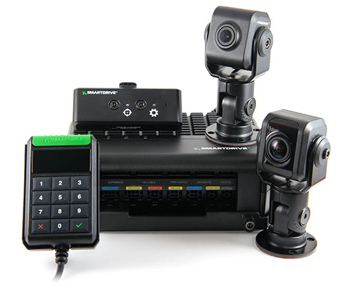
The SmartDrive SR4 video hardware platform. (Photo: SmartDrive Systems)
SmartDrive and Geotab are helping to simplify the on-board technology footprint, providing fleets the freedom to choose solutions that fit their business and their budget, and dramatically lowering the total cost of ownership.
SmartDrive offers a single integrated and aligned understanding of time, location and driver and vehicle performance to third-party applications. Fleets will be able to select solutions without incurring the additional costs associated with managing and maintaining multiple onboard devices.
“The ability to integrate and operate applications from a single data collection platform breaks through significant technology and operational barriers — unlocking efficiency gains for fleets across routes, drivers and risk,” said Steve Mitgang, SmartDrive CEO. “Collaborating with Geotab allows us to make good on the promise of convergence with a company that shares our commitment to providing open, connected and flexible solutions for fleets of every size. We believe this is a transformational shift — and it’s only the beginning of what is possible for our customers.”
With the growth of technology in the cab, fleets are struggling with how to manage the number of devices on the windshield and the connection of those devices in the vehicle.
Video-based safety cameras, electronic logging devices and advanced driver assist system (ADAS) sensors are causing fleets to look for integrated solutions that solve the hardware and data overload problem. Beyond the number of devices on the vehicle, fleets also are contending with the cost to install, maintain and train on each of these technologies. With the migration from 3G cellular networks to 4G, and resulting need to upgrade onboard hardware, fleets have an opportunity to re-think and streamline their technology strategy.
“For too long, traditional telematics systems have saddled fleets like ours with costly hardware that is expensive to maintain and upgrade, and monthly subscription costs that continue to escalate,” said Matt Penland, vice president of safety, Cypress Truck Lines. “There has to be a better way. Fleets should have the same freedom and flexibility to consolidate devices and applications that we all now have on our cell phones. The technology is available to make this possible.”
The SmartDrive platform provides a unified video and telematics data stream that can be leveraged by third parties to power their applications, the companies said. This same data stream powers the SmartDrive video safety program, ADAS and transportation analytics applications.
Through the collaboration, Geotab telematics and compliance offerings take advantage of the SmartDrive single box architecture and unified data stream, eliminating redundancy across hardware, cellular connectivity, GPS modules, connections to the ECU and cabling. It also provides data alignment across the two providers’ applications, unlocking new fleet performance insights and eliminating problematic data discrepancies.
As a result of the collaboration, fleets can benefit from:
The SmartDrive video safety program
SmartDrive SR3 or SR4 video hardware platform
“Single box” architecture enabling the convergence of data, devices and network connectivity
Analytics powered by SmartDrive SmartIQ
Geotab tracking, which delivers real-time and historical visibility to location, speed and geofencing information
Geotab regulatory compliance, including hours of service, driver vehicle inspection reports, International Fuel Tax Agreement (IFTA) recording and tax reports
Access and integration to Geotab Marketplace partners.
“Geotab’s open platform centers on a reliable, scalable and secure approach to data access for business solutions,” said Colin Sutherland, executive vice president of sales, Geotab. “We have always said that our hardware is agnostic. The SmartDrive video hardware integration is a solution that not only leverages Geotab’s platform strength to incorporate data from non-Geotab hardware, but it is a great example of telematics solutions that extend the capital investments across multiple solution providers.”
With more than three billion data points collected daily from over one million vehicles, Geotab helps companies access critical business intelligence and benchmarking data to help increase productivity, reduce fuel consumption, improve driver safety and strengthen compliance.
The integration with Geotab will be generally available early in the first quarter 2019, and the SmartDrive convergence early adopter program is in progress.
Current and prospective customers will be able to take advantage of the integration to Geotab from either the SmartDrive SR3 or SR4 platform.
Released in March 2018, the new SR4 hardware includes unprecedented compute power in a small, flexible footprint; new sensors for advanced risk identification and real-time driver-assist; innovative architecture enabling the convergence of data, devices and network connectivity; new analytics powered by SmartDrive SmartIQ; and a video safety program.
Wyzelink Systems’ IoT workflow-automation application, WyzeTask, is now available in the Geotab Marketplace. WyzeTask is the newest application in the marketplace and is a complement to the MyGeotab platform, which serves more than 14,000 Geotab customers.
WyzeTask maximizes employee productivity by automating task tracking and job completion processes, freeing workers from paperwork and manual data entry. Automation also maximizes record accuracy by avoiding the errors that come with manual entry.
The WyzeTask solution includes the WyzeBeacon, a wearable device that uses Bluetooth Low Energy (BLE) to transmit data to a nearby BLE scanner, which can be a Geotab IOX-BT hub or a smartphone/tablet running the WyzeTask application. Employees simply click a button on their WyzeBeacon to have it log and share information such as their task status, time and GPS location.
Designed for field workers in public works, construction and manufacturing, WyzeTask leverages Geotab’s IOX-BT hub to reliably transmit data even when they’re away from their smartphone or IOX-BT-enabled vehicle.
WyzeTask includes an easy-to-navigate Geotab webAdd-in with an interactive map that allows administrators to view task progress and other key information. A mobile app also lets supervisors assign and change worker’s tasks from the job site or remotely.
“Wyzelink creates intelligent solutions for workforces outside of a typical office building with wireless IoT technology, smart sensors and wireless applications,” said Brian Barry, Wyzelink Systems CEO. “By closely tracking workforce tasks, businesses can cut through the tedious paperwork process and focus on core responsibilities while improving efficiency, productivity and workplace safety.”
“The addition of Wyzelink provides increased IoT capability as we continue to create an impressively connected ecosystem for Geotab’s Marketplace customers,” said Joey Marlow, Geotab executive vice president of U.S. operations. “Through Geotab’s IOX Bluetooth hub, telematics tracking and data collected from WyzeTask, management now has the ability to collect and analyze workforce data to deliver business intelligence.”
The Geotab Marketplace provides an extensive ecosystem of valuable business focused applications and Add-Ons, helping customers add value to their Geotab fleet management solution. Launched in 2015 as a complement to the MyGeotab platform, the marketplace is used by more than 14,000 Geotab customers.