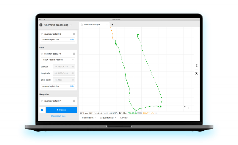
Emlid has released Emlid Studio, a new post-processed kinematic (PPK) application designed specifically for post-processing GNSS data. The app is free and available for Windows and Mac users.
Emlid Studio features a simple interface to make post-processing easy. The app allows users to convert raw GNSS logs into RINEX, post-process static and kinematic data, geotag images from drones (including DJI brand), and extract points from survey projects completed with Emlid’s ReachView 3 app.
With Emlid Studio, users can post-process data recorded with Emlid Reach receivers and other GNSS receivers or NTRIP services. Post-processing requires RINEX observation and navigation files. Raw data in UBX and RTCM3 format also can be used — Emlid Studio will automatically convert them into RINEX.
The post-processing workflow is straightforward. Users can receive precise positioning of a single point or track depending on the positioning mode. Users can simply add several RINEX files and enter the antenna height, click the Process button, and Emlid Studio will do the rest. Once the resulting position file is ready, the plot will show the result.
Another tool is available for the users of Reach receivers and the ReachView 3 app. The Stop & Go feature allows users to improve the coordinates of points collected in single or float modes.
Geotagging for drone mapping. Adding geotags to images’ EXIF data requires aerial photos and the POS file with the events. Emlid Studio also provides a chance to update data from the RTK drone in case of a float or single solution during a survey. A set of RINEX logs from a base and drone, an MRK file and images from the drone are dragged and dropped into specific file slots, providing result in seconds.
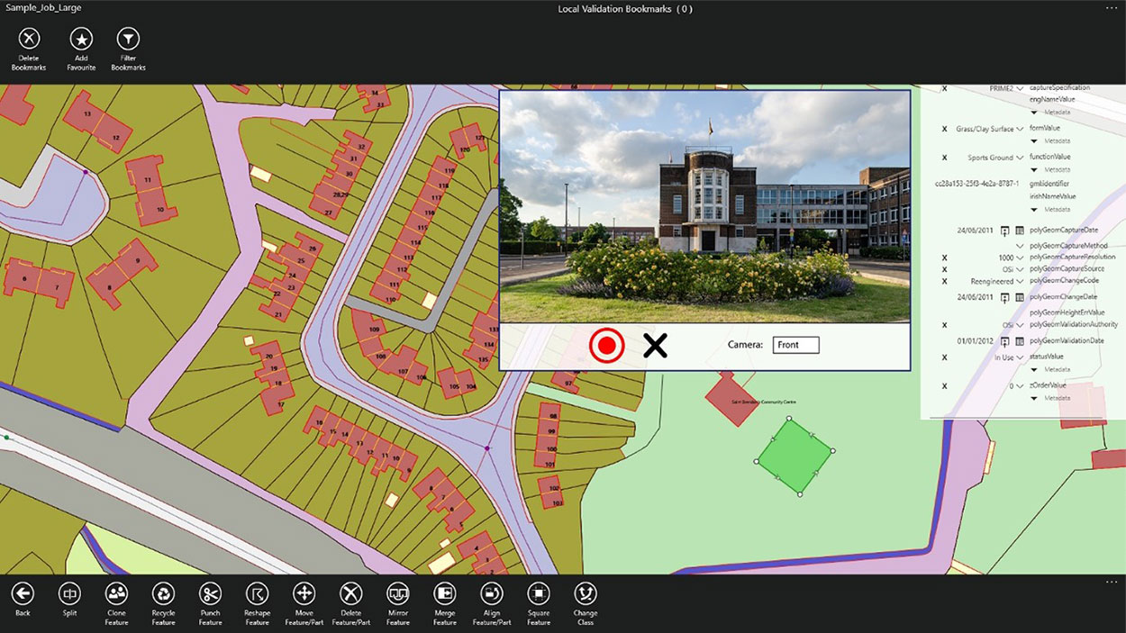
1Spatial has extended the capability of its survey application 1Edit, increasing support for photos and 2.5D data.
1Edit 3.1 allows users to attach feature photos, including automated geotagging, which enables surveyors to visualize assets and fine-tune their observations. The latest version now includes new validation functions and improved handling for heights (2.5D data), typically useful for detailed asset and land-management surveys.
Enhanced styling, including bitmap fills and dashed lines, make it easier to identify and classify different asset types during surveys. Additional control of editable layers and fields provide protection for non-editable data and protects the quality of data. Significant improvements to rendering of thematic mapping further enhances the speed and fluidity of the intuitive user interface.
1Edit also now supports the storage of photographs as an attribute on a feature. The photos can be captured from the front or rear camera and are stored as a Label object.
“1Edit’s new survey capabilities further expands our customers’ ability to collect trusted, validated data that is right first time,” said Robert Chell, chief product officer. “By increasing the number of validation options available during a survey, we improve both the quality and accuracy of data, and the effectiveness of survey processes.”
Avalanches can be a danger for skiers as well as for the resort towns that welcome them. For protection, towns erect steel fences to act as barriers along the ski slopes. But before these snow barriers can be built, steep rock faces and cliffs need to be surveyed.
Darnuzer Ingenieure AG, a Swiss-based surveying and mapping company, uses a drone with a built-in high-performance GPS receiver to survey these harsh areas in hours.
“Drones have made mapping workflows faster, safer and more efficient,” said Septentrio’s senior market access manager Gustavo Lopez. “GNSS technology has led to the evolution of post-processing kinematic (PPK) methods, which help make the photogrammetry process efficient and accurate.”
Every year, thousands of tourists visit Davos in the Swiss Alps. To protect the town and the skiers, avalanche barriers were built along the steep slopes. To plan the work along the uneven rock face, a detailed 3D reconstruction of the area was needed, but getting to the survey site would be a rock-climbing feat.
Darnuzer Ingenieure used the WingtraOne fixed-winged drone, which features a top-quality camera and a Septentrio high-performance GNSS receiver. A single surveyor took the drone to the rocky Parsenn slope during the summer season, capturing ground images — without snow — that were needed for the 3D model.
WingtraOne PPK enabled high-precision mapping without the need for ground control points. During the flight, each image was accurately time-stamped and raw GNSS data from the Septentrio AsteRx-m2 receiver was carefully logged.
Even in this mountainous region, where peaks obstruct the sky, the receiver delivered continuous positioning. The GNSS data was processed by the GeoTagZ software library, which used corrections from a nearby base station to generate real-time kinematic (RTK) centimeter-level positioning.
The GeoTagZ software library incorporated Septentrio’s core GNSS algorithms to assure the best positioning performance. Accurate positioning was then synchronized with the images in the next step of the post-processing workflow.
It only took Wingtra a few days to integrate the GeoTagZ library into its WingtraHub software package. Integration of GeoTagZ into WingtraHub simplifies mapping jobs for customers like Darnuzer Ingenieure.
“The beauty of this solution is that the drone benefits from the receiver’s high-quality raw measurements without the need for a real-time corrections link for accuracy,” Lopez said. “The quality of the measurements comes from the technology built into Septentrio’s receivers, which is designed to be resilient to radio frequency interference and multipath. In post-processing, the GeoTagZ software enables the most accurate positioning, thanks to its high-performance RTK engine.”
NavVis, a provider of indoor spatial intelligence technology, can now automatically convert E57 point cloud files into interactive, realistic 360-degree walkthroughs, following the latest software upgrade to IndoorViewer.
Visitors to Intergeo 2018 can demo the new NavVis IndoorViewer release as well as the NavVis M6 indoor mobile mapping system by visiting NavVis in Hall 12.1 at booth 12.1D.086.
Image: NavVis
NavVis IndoorViewer is a web-based application that displays realistic digital twins using 360-degree panoramic images, point clouds and maps generated by 3D scanning devices. Users can move around digital twins of scanned spaces as if they are on site and use the interactive functionality to add, search for and route to geotagged information and take accurate measurements.
The intuitive user interface and functionality has made NavVis IndoorViewer a valuable deliverable for laser scanning professionals who want to extend the use of point clouds beyond BIM models and building plans to a wider range of building stakeholders who would also benefit from 3D scan data.
This is particularly relevant for stakeholders working on complex projects or properties, such as manufacturing facilities and construction sites, where IndoorViewer enables remote access to the site and is used as a platform for collaboration and exchanging information, the company said.
“IndoorViewer was originally developed to display the data captured by our indoor mobile mapping system in a way that is accessible to every user,” said Felix Reinshagen, NavVis CEO. “In recent years, we have seen that making scan data available to every building stakeholder is fulfilling an unmet need. Many of our partners using a NavVis indoor mobile mapping system for conventional scanning projects are offering IndoorViewer as an additional deliverable to increase the number of stakeholders who can make use of this data.”
“To meet the growing demand for extending the use of valuable 3D scan data, we developed a feature that automatically renders 360-degree immersive images from structured E57 point cloud files. The latest software release brings the full functionality of IndoorViewer to E57 point cloud files and therefore marks an important step towards our goal of making scan data meaningful for every building stakeholder.”
NavVis IndoorViewer currently supports third party point cloud files in most standard formats. However, a key component of the immersive experience that NavVis IndoorViewer provides is the 360-degree panoramic images.
The new IndoorViewer feature bridges this gap for structured E57 files by automatically rendering 360-degree immersive imagery from E57 point cloud files. This means data collected by terrestrial laser scanners can now also be used to create realistic, immersive 360-degree walkthroughs that can be published and shared online without the need to download or install software.
The E57 panorama extractor is available as part of a free software upgrade to IndoorViewer subscribers.
Webinar participants will learn how to add GPS coordinates — latitude and longitude — to videos and photos in real-time and post process. They will also learn how to view and analyze data in Esri ArcMap and Google Earth maps.
Jan Leyssens, product manager at Septentrio, gives details on the low-power AsteRx-m UAS, which offers centimeter-level accurate geotagging of images, stabilized VTOL hovering and solid interference mitigation.
Red Hen Systems‘ MediaMapper Mobile is an Android app that lets users snap a photo, record a video, make an audio note, and collect project data, while automatically geotagging it. The result is geotagged media that when displayed will show its exact location on a map. The media can be shared via email or a direct upload to a server.
“MediaMapper Mobile is unique because it geotags photos as well as audio and video,” said President and Founder Neil Havermale. “This easy-to-use app has the ability to geotag information and display it on a map, allowing users to analyze and respond quickly and efficiently to what is happening in the field. It is the simplest and most affordable high-tech solution for detecting, gathering, and analyzing geospatial information.”
MediaMapper Mobile offers a convenient way to collect and geotag media in the field. It connects wirelessly to GIS equipment to collect geotagged video, audio, and high-resolution imagery.
Using MediaMapper Mobile, gas and pipeline inspectors, pilots, and natural resource managers in the field can collect visual and audio recordings of what they see and hear along pipelines, coastlines, forests, and more. They can fill in inspection and collection forms while traveling, and gather diverse sensor data such as percent humidity, temperature, slope distance, and azimuth. GPS details about location, such as time, latitude, longitude, and altitude are viewable.
Once data collection is complete, media files can be transferred to a laptop or computer to view and analyze using Google Earth or Red Hen Systems isWhere software. There is no need for extra equipment — MediaMapper Mobile has the necessary features to gather and record a wide variety of essential data.
This version of MediaMapper Mobile is improved over older versions because it can interface with various Bluetooth devices (GPS receivers, Laser Range Finders, Blue2CAN), collect features of interest, take sequential photos based on time and distance intervals, and control external cameras such as GoPro from the Android device. Red Hen Systems added features and gave it an extensive user interface makeover to enhance its appearance and usability.
CSR plc and OriginGPS have announced a series of high- performance GNSS modules using CSR’s SiRFstarIV and SiRFstarV product lines.
The new modules are 70% smaller than current solutions and deliver a 30% reduction in Time To First Fix (TTFF), making them ideal for health and fitness trackers, sports watches, medical devices, wearable action cameras, and digital still cameras. All modules, including the newly released 7 x 7 millimeter Multi Spider (ORG4572) solution, integrate the LNA, SAW filter, TCXO, RTC crystal and RF shield.
“To accelerate market adoption of location technologies in wearable devices and cameras, manufacturers must minimize the embedded GNSS module size without compromising on performance, sensitivity, or power consumption,” said Anthony Murray, senior VP, Business Group at CSR. “By leveraging CSR’s industry-leading GNSS solutions and collaborating with OriginGPS on module development, we have achieved this objective.”
The OriginGPS modules offer high sensitivity resulting in shorter autonomous and aided TTFF, better navigation stability, and higher accuracy in harsh environmental conditions. In real-life testing of the module in camera applications, TTFF performance improves by over 30 percent compared to other solutions. The module also delivers TTFF results in less than one minute over 90% of the time (cold starts).
In addition to its small footprint, the GNSS module’s ultra-fast geotagging capability dramatically improves the consumer experience. The GNSS antenna module’s outstanding sensitivity and OriginGPS’ proprietary Noise Free Zone (NFZ) technology for faster position fix and navigation stability provides geo-tagging availability even under challenging satellite signal conditions such as low signal areas, under dense foliage, in urban canyons, and during motion-based activities. Battery life is considerably extended as a result of CSR’s breakthrough low power Push-to-Fix (PtF) technology, which rapidly establishes a valid position fix enabling the module to hibernate for longer periods of time. Push-to-Fix is an intelligent periodic low power mode that adaptively changes power depending on the operating environment and motion conditions. Advanced algorithms and a powerful on-chip DSP processor maintain high accuracy (QoS) while achieving the lowest power level possible for the given environmental and motion conditions.
“As the wearable technology and action camera markets continue to grow, we must ensure that our solution meets the market’s need for high performance and small form factor GNSS modules,” says Gal Jacobi, CEO of OriginGPS. “It is our privilege to partner with CSR and its excellent engineering team to meet the market’s need. CSR’s leading multifunction semiconductor platforms and OriginGPS’ miniaturized high performance modules create a unique value proposition for customers in these markets.”
OriginGPS modules are currently in mass production, and additional information can be found at www.origingps.com.
Topcon Positioning Group announces a new data controller — the FC-500 — with numerous features and benefits, including a large 4.3-inch touchscreen display and 5MP camera with built-in LED flash.
The FC-500 is designed for the professional operating Topcon MAGNET Field, Site and Layout software and Topcon’s Pocket 3D.
Ray Kerwin, director of global surveying products, said, “The FC-500 works with all Topcon GPS/GNSS receivers and total stations, and meets or exceeds all field application requirements. Additionally, the FC-500 works with the new Topcon LN-100 instrument dedicated to BIM and one-person construction layout, simplifying workflow with the seamless integration with our MAGNET suite of software solutions.”
Kerwin said, “With a sunlight readable screen, the controller is easy to use even in bright sunlight. It is the ideal job site controller in any condition (waterproof up to one meter, IP68 rating) and the large camera format with built-in LED flash and built-in 8GB flash storage allows the storing of hundreds of job site photos.”
The standard model has both Bluetooth and Wi-Fi connectivity, while the FC-500 GEO has Bluetooth, WiFi and GPS. A third model comes with the addition of a 3.5G cellular modem that allows access to the MAGNET Enterprise Solutions suite, “making the FC-500 the perfect field instrument for sending and receiving data files to the MAGNET cloud,” Kerwin said.
For the GIS professional using MAGNET Field software, the FC-500 has a geotagging feature that allows imprinting file information, including GPS location, directly on photos.
Swiss-based u-blox has been chosen by Leica Camera as provider of GPS technology for its premium M-System camera and accessory series.
Leica, which makes high-end and professional cameras, has integrated u-blox’ NEO GPS module into its new Multifunctional Handgrip M. The geotagging feature injects location data directly into each photo’s Exif header (Exchangeable image file format), allowing photos to be filed and retrieved according to where they were taken. The accessory is compatible with the new flagship Leica-M rangefinder digital camera series.
The Multifunction Handgrip M connects directly to a computer via an integrated USB socket, allowing full remote control of the camera and image access using the Leica Image Shuttle software package. The handgrip also facilitates the safe and steady handling of the camera, particularly when shooting with heavier telephoto lenses.
The handgrip’s features include a supplementary flash connector, a socket for an external power supply, and a sync socket for studio flash systems. An optional supplementary power source is also available.
“Leica focuses on providing the highest quality photographic equipment on the market,” said Stefan Daniel, director of product management at Leica Camera.“When a customer purchases a Leica, they realize they are making an investment in a robust, high-performance camera that delivers outstanding results. To meet these expectations, we design with only the best mechanics, optics and electronics. For global positioning, we chose u-blox.”
“We are proud to have been selected for our GPS technology by such a prestigious brand as Leica,” said Jochen Steinhauer, u-blox sales manager. “When you pick up a Leica camera, you immediately see and feel the high quality of every component. It is designed for perfection, a philosophy that u-blox also follows in our design of the world’s highest-quality global positioning modules.”
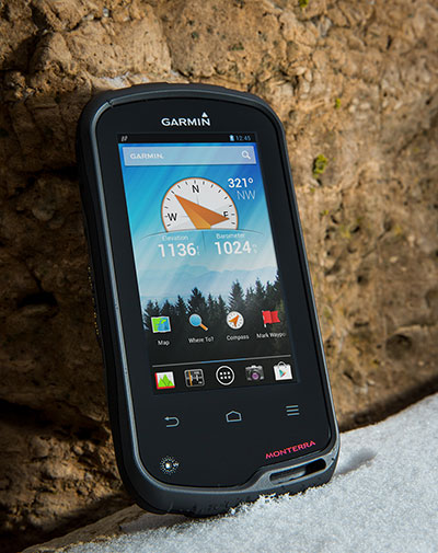
Garmin International Inc., a unit of Garmin Ltd., maker of popular GPS devices such as the nuvi, has announced its first Wi-Fi-enabled outdoor handheld GPS running the Android operating system, Monterra.
Monterra has a vivid, sunlight-readable touchscreen, and users can easily access the Google Play Store and download apps through an available Wi-Fi connection on the device. Developers can create new apps that are suited for the rugged, waterproof, and sensor-loaded handheld device.
“Monterra provides outdoor professionals and enthusiasts with the ultimate ability to customize their GPS device to perfectly suit their personal and professional needs,” said Dan Bartel, Garmin’s vice president of worldwide sales. “With a four-inch, color, multi-touch display, unique 3D MapMerge, and the ability to create new apps, Monterra takes the outdoor GPS to a whole new level, and users are able to take advantage of the features no matter how adverse the terrain may be.”
With the Android operating system, users are able to access popular outdoor-related Android apps, such as Peak Finder, as well as professional apps like construction estimators and ArcGIS to extend some office functions to the field. Monterra also has a built-in FM radio and NOAA weather radio with SAME alerts, so users can receive watches and warnings related to their location. Users can either listen with headphones or through the built-in speaker.
Monterra has a built-in 3-axis compass with accelerometer and gyro, which indicates the user’s direction even when standing still or not holding the device level. Its barometric altimeter has the ability to track changes in pressure to pinpoint precise altitude, and it can also plot barometric pressure over time to monitor weather conditions. It also has a built-in UV sensor so users can monitor the intensity of the sun, and reduce exposure if necessary. With its high-sensitivity, dual-band GPS and GLONASS receiver, Monterra finds its location quickly and maintains signal lock even in heavy cover and deep canyons.
New to the Monterra is a unique mapping feature: 3D MapMerge. With this feature, users can combine two maps — like TOPO, basemap, or BirdsEye Satellite Imagery — then view the new unique map in three dimensions. Hills, valleys, lakes, roads, and points of interest combine to give Monterra’s maps unequaled detail and richness. Combine BirdsEye with TOPO US 24K, or a GIS-based water table map with a shaded relief basemap, then zoom in, pan out, and rotate the 3D map using multi-touch.
Monterra has a built-in 8-megapixel autofocus digital camera that takes geotagged photos, plus a 1080p HD video camera with LED flash. Users can download photos and videos to their computer for either work or sharing using Garmin Adventures. Monterra has 8 GB of internal memory built-in plus a microSD slot for even more extra storage.
Monterra features a vivid and highly durable mineral glass display that uses sunlight in combination with the unit’s LED backlight to increase brightness and view-ability. It has an IPX7 waterproof rating and also uses a dual-battery system, which allows users the option of using the rechargeable Li-ion pack (included) or traditional AA batteries. It is also compatible with the same mounts as the Garmin Montana, so users can take Monterra anywhere.
Wireless sharing is easy with Monterra. It has WiFi, ANT+, Bluetooth 3.0 and NFC capabilities, which allows users to share data, maps, waypoints, tracks, routes, and geocaches with other wireless compatible devices. Additionally, Monterra is compatible with BaseCamp, a free software download that lets you view and organize maps, waypoints, routes and tracks.
The new Garmin Monterra will be available third quarter 2013 at a suggested retail price of $649.99 (Worldwide with preloaded worldwide basemap), and $699.99 (U.S. with preloaded TOPO U.S. 100K with Navteq roads).
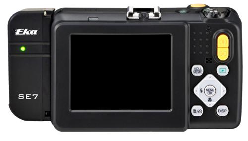
Ricoh Americas Corporation announced a new module for Ricoh digital cameras that provides the most advanced solution for precise, secure and portable military-grade photo/video geotagging.
Available in August, the thumb-sized Ricoh SE-7 GPS hardware module bolts on to the ruggedized Ricoh G700SE digital camera. This combination enables users to automatically geotag images with location information immediately useful in navigation, mapping, planning, analysis, strategy, reporting and more.
“The SE-7 module gives the military and other users important new capabilities for fast, precise and secure geotagging under less-than-ideal conditions,” said Yuki Uchida, Vice President, New Business Development, Ricoh Americas Corporation. “There’s a lot going on in this ultra-compact module to help soldiers and others be more successful in their work.”
According to the announcement, the module, which sets a new standard in global positioning system (GPS) speed and accuracy, offers a more compact and convenient geotagging solution than traditional systems requiring a laptop-camera combination. The SE-7 also generates location coordinates down to the meter, which is far more precise than consumer-grade products. For even better accuracy, the Ricoh G700SE/SE-7 combination is forward-compatible to 18-satellite GPS processing, a military standard scheduled to take effect in 2016.
Ricoh reports that the SE-7 module integrates directly with attachable laser range finders, includes a built-in compass for directional data capture, enables barcode tagging, and provides full support for selective availability anti-spoofing modules (SAASMs). SAASMs ensure GPS precision and accuracy even in the presence of malicious jamming and spoofing.
Tagging
The camera/module combination supports up to 20 memo fields that are customizable for tagging photographs with valuable data. Example data tags are photographer’s name, operation ID, operation type, unit ID and more. This information, along with GPS coordinates, GPS date and Zulu time, are automatically stored as metadata in each image file on the G700SE.
Mapping and direction
The SE-7’s GPS Track-Log feature maps the geographic path by which photographs are collected. An integrated electronic compass allows users to accurately record the direction in which a photograph is taken regardless of the angle at which the camera is held. After images are collected in the field, data is uploaded using the camera’s built-in wireless, Bluetooth or USB connection in preparation for analysis, mapping and reporting.
Formats
GPS coordinates collected with the SE-7 module can be displayed in a variety of formats directly on the camera, including LAT/LONG, MGRS, UTM and combinations of each, depending on user requirements. Data is compatible with a broad range of software, and images are plotted as a spatial data layer along with tagged information.
Laser range finder integration
Range finder integration allows users to tag not only where the picture was taken, but the location of objects in the distance being photographed.