The survey is designed to gather information from organizations using GIS technology, to learn about how they organize and GIS, and provide services to their users.
All respondents will receive a report of survey results.
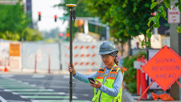
The Trimble DA2 receiver boosts the performance of the Trimble Catalyst GNSS positioning service. (Photo: Trimble)
Trimble has launched the Trimble DA2 GNSS receiver for the Trimble Catalyst positioning service. The DA2 — the second-generation receiver and antenna for the Catalyst service — now includes the Trimble ProPoint GNSS engine for enhanced performance.
Unique to the latest Trimble GNSS solutions, ProPoint technology reduces convergence times and improves positioning accuracy when operating near trees and buildings.
Trimble Catalyst is a subscription-based GNSS positioning service for location-enabled field applications. The service is available in accuracy-based packages from centimeter- to submeter-level for a wide range of mapping and mobile geographic information system (GIS) data-collection projects. Catalyst continues to support a broad range of GIS field applications, including Trimble TerraFlex software, for form-based GIS data collection.
“Trimble Catalyst brings easy-to-use precise positioning to location-enabled workforces,” said Gareth Gibson, marketing director, Trimble Mapping & GIS. “The addition of ProPoint technology, together with the DA2’s support for iOS devices, means Catalyst can now deliver Trimble quality positioning to more geospatial professionals than ever before.”
Trimble Catalyst subscriptions are available through Trimble’s Authorized Distribution Network. The Catalyst DA2 digital GNSS receiver, sold separately, is expected to be available in the fourth quarter. Trimble TerraFlex software subscriptions are available separately through Trimble Geospatial distribution partners.
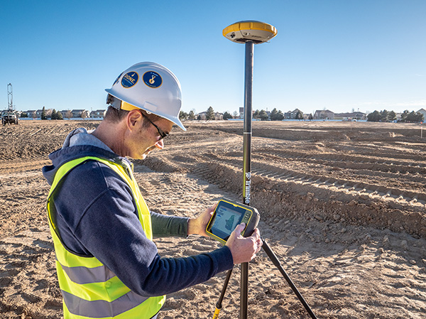
The University of Colorado – Denver has received a significant gift from Trimble to establish a state-of-the-art technology lab for the College of Engineering, Design and Computing.
The gift will also support the departments or programs in construction engineering and construction management, geography and environmental sciences, physics, and urban and regional planning. The lab will expand the university’s access and expertise in a customized suite of construction hardware and software products.
Trimble’s broad Connected Construction portfolio enables professionals along the project lifecycle to accelerate project processes — improving productivity, quality, transparency, safety and sustainability, while reducing waste.
The Trimble Technology Lab will provide students enrolled across relevant programs hands-on experience with a wide breadth of Trimble solutions. The lab will expand the university’s access and expertise in project management, architectural and structural analysis, design and engineering, mixed reality, 3D scanning, office-to-field solutions, and GIS data collection and GNSS positioning.
Partnering with Trimble allows the University of Colorado – Denver to integrate the latest technology into its curricula, empowering graduates to rapidly transform how buildings and living environments are designed and constructed.
The lab will include a broad range of Trimble’s technologies.
Hardware includes the Trimble XR10 HoloLens with hardhat, TX8 3D laser scanner, Trimble SiteVision AR system, R12 GNSS systems, Juno 5D handheld scanner, Geo 7x mobile GNSS data collectors, robotic total stations and field tablets.
Software solutions include RealWorks scanning software, Trimble Business Center, Tekla Structures, Tekla Structural Designer, Tekla Tedds, Trimble Connect, ProjectSight, Viewpoint, TILOS, Trimble Positions Desktop, TerraSync and TerraFlex, eCognition, and the company’s 3D modeling software, SketchUp Pro.
“CU Denver is right in our backyard, providing an exciting opportunity to integrate our industry-leading technologies into a wide range of educational programs. Their proximity enables us to work closely while ensuring easy access, training and support, and success in all aspects of implementation,” said Allyson McDuffie, director of Education & Outreach at Trimble. “Trimble’s education and outreach programs aim to support the next generation of influencers by actively working with key education institutions to ensure Trimble’s portfolio of solutions are accessible and implemented in higher education curricula and research programs, creating a new workforce equipped and empowered to ‘Transform the Way the World Works.’”
Martin Dunn, dean of the College of Engineering, Design and Computing, said, “I am thrilled with and grateful for this exciting relationship with Trimble. It will accelerate our strategic vision to educate diverse graduates who will not only make an immediate impact in the AEC industry, but will emerge as its future leaders. The generous gift will have broad impact across our campus, nucleating the kind of interdisciplinary collaboration among engineers, architects, construction managers, and scientists that is needed to create and exploit technological innovation to address grand challenges facing the built environment including digital transformation, sustainability, and the future of work and the workforce.”
“Our students and faculty could not be more excited to have access to Trimble technologies. Trimble is a company of international importance, which is also right down the road from our campus. In establishing this new lab, our students will be exposed, either virtually or on-site, to cutting edge products and innovation as well as benefit from direct access to the many professionals in Trimble’s worldwide network. Trimble is exactly the type of company that gets our students excited about pursuing careers in construction and engineering,” said Caroline Clevenger, associate professor and director of Construction Engineering and Management.
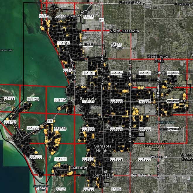
City officials in Sarasota, Florida, kept their staff actively working during COVID-19 social distancing mandates by training and tasking them with mapping utility data in the field.
The city’s plan to rebuild its GIS database had an estimated five-year timeline. GIS Coordinator William Rockwell suggested to city manager Tom Barwin that those unable to work from home be trained to collect the data. Rockwell worked with Sarasota IT Director Herminio Rodriguez to calculate the cost of acquiring enough GNSS receivers for the idle staff to use, and discovered a substantial cost savings.
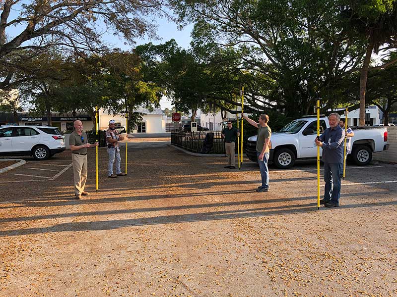
Hands-on training took place in the Sarasota City Hall parking lot, with trainees practicing social distancing. (Photo: Eos Positioning)
“By implementing this project, we not only keep city staff productive, but we’ll also be collecting data that would otherwise cost hundreds of thousands of dollars if we outsourced the work,” Rockwell said.
Training from a Distance. Rockwell obtained affordable Arrow 100 GNSS receivers from an Eos Positioning distributor and hosted small-group training sessions in the city hall parking lot. Employees from a multitude of different departments were trained, such as a parking enforcement officer and a transportation planner.
All employees were carefully kept six feet apart. From a maintained distance, Rockwell explained the basic concept of data collection using high-accuracy Arrow 100 receivers with ArcGIS Collector.
The new team mapped 93% of street lights and road signs in one month. (Photo: Eos Positioning)
The employees took turns collecting sample data so Rockwell could address any initial concerns. He also gave each of them a printed map series, created in ArcGIS Pro, that showed the city divided into 28 grids. This allowed the team members to easily mark off where they collected data each day.
At the end of each day, the workers synced their data, collected by the Arrow 100s, to ArcGIS Online, which allowed Rockwell to monitor progress.
To date, 14 field workers have collected 93% of the city’s 6,000 street lights and 16,000 road signs. Although the 30-day project pilot has finished, the city plans to collect the remaining lights and signs, as well as the city’s 35,000 trees, later this year. High-accuracy GIS data collection has received encouraging feedback from management.
“I’m thrilled the city is supporting this initiative,” Rodriguez said. “To be able to take employees doing very, very different jobs and put them in the field — this wouldn’t have been possible in a normal environment. We are excited that everyone is chipping in.”
Trimble has introduced Penmap for Android, a cloud-connected application for field surveying and high-accuracy geographic information system (GIS) data collection that works on mobile handhelds, smartphones and tablets.
Trimble Penmap for Android focuses on core survey and mapping tasks such as cadastral and boundary surveys, as well as establishing local control, stake-outs, quality checks and asset management for utilities. It provides both professional surveyors and field workers with an intuitive, easy-to-use map-based interface to manage features and attributes for high-accuracy GIS and complete survey documentation.
The application is also ideal for use in the energy distribution industry for locating infrastructure and recording critical information on encroachments, clearways and existing monuments, the company said.
The application runs on a variety of Android devices, including the rugged Trimble TDC100 handheld, and supports full-featured Trimble GNSS receivers such as the Trimble R10, R8s and R2 receivers.
Trimble Penmap for Android is optimized to integrate with the new Trimble Catalyst service, a software-defined GNSS receiver that connects to the small, inexpensive plug-and-play DA1 antenna, and allows surveyors to choose an accuracy level from meter to centimeters to suit their application needs.
Together, Penmap and Trimble Catalyst — both purchased through a fixed monthly subscription — offer an on-demand, lightweight and low-cost professional surveying system that provides value, convenience and flexibility, the company added.
“The addition of Penmap expands our portfolio to address the needs of organizations that require a value-packed, flexible survey system,” said Matt Delano, general manager of Trimble’s Land Administration solutions. “Surveyors using the Penmap application with Trimble Catalyst can easily manage seasonal shifts in survey activity by scaling up or down without a capital investment. Survey managers will find it an efficient way to carry out field checks without tying up expensive equipment used by their field crews. They can simply use a phone, the Penmap application, a Catalyst subscription and the DA1 antenna.”
Trimble Penmap for Android includes the Penmap Project Manager, which is used to set up projects, create templates and add team members.
Penmap Project Manager works with the Trimble Connect platform for storing and transferring data between the field and office.
Trimble Connect, which is also included in the Penmap subscription, is a collaborative cloud-based platform that enables organizations to set up and deploy projects to their field users. Information collected in the field is synced back to the office in real-time where it is stored, managed and communicated to team members.
Data can also be exported from Penmap Project Manager into back-office systems in a variety of file formats for viewing and sharing.