Tag: GLA

  • Alan Grant named R&D head of General Lighthouse Authorities

    Alan Grant named R&D head of General Lighthouse Authorities

    The General Lighthouse Authorities (GLA) of the United Kingdom and Ireland has named Alan Grant to the top post of its research and development team. Grant assumed his new role on Nov. 1.

    As part of his duties, he heads the GLA’s research and development program, considering existing and future maritime requirements and operational strategy. GLA Research and Development (GRAD) is tasked with improving maritime safety by developing innovative and cost-effective maritime aids-to-navigation (AtoN).

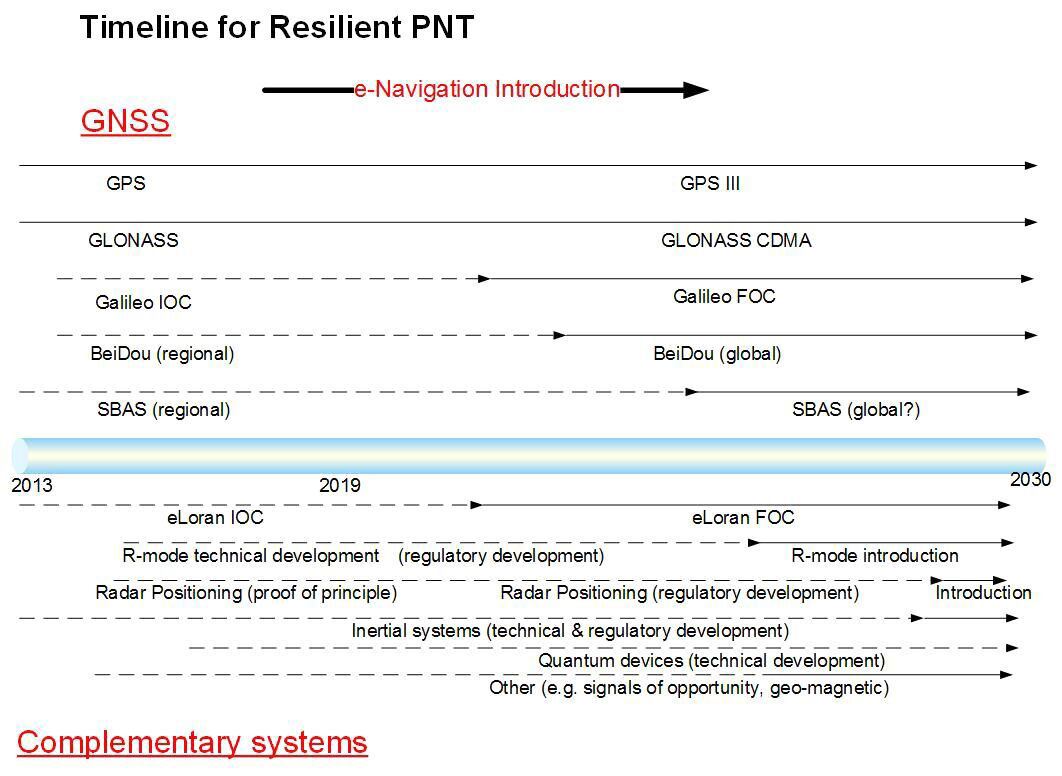
    GRAD projects have included all aspects of AtoN including human and machine interaction, operational life and environment. The team has deep technical expertise and experience with automatic identification systems (AIS) , the VHF Data Exchange System (VDES) , eLoran, e‑navigation, GNSS, SBAS and visual signaling.

    The organization is well known for its expertise in electronic navigation aids and was an important contributor to the MarRINav project. The project effort was funded by the European Space Agency and examined what combination of electronic aids to navigation are needed to ensure uninterrupted UK shipping.

    Grant joined the GLA in 2003 and has worked on a variety of systems during his time with GRAD.  He led a series of successful GPS jamming trials and the development of the multi-system radionavigation receiver performance standards, from initial concept to international recognition at the IMO. He continues to support resilient positioning, navigation and timing in maritime navigation at both technical and strategic levels.

    Grant is a Fellow of the Royal Institute of Navigation, where he is a member of the council and served as vice president, 2019-2021.  He is also a member of the U.S. Institute of Navigation and served on the ION Council, 2013-2017.

    Grant chairs the International Association of Marine Aids to Navigation and Lighthouse Authorities (IALA) radionavigation services working group and is a member of several international standards bodies. He is a chartered engineer, a chartered physicist, and author of more than 120 journal papers, magazine articles, and conference papers.

    Martin Bransby, the prior GRAD leader, has taken a position with Telespazio in the UK.

    Longstone Lighthouse is situated on the Outer Farne Islands on the Northumberland Coast in Northern England. (Photo: ad_foto/iStock/Getty Images Plus/Getty Images)
    Longstone Lighthouse is situated on the Outer Farne Islands on the Northumberland Coast in Northern England. (Photo:
    ad_foto/iStock/Getty Images Plus/Getty Images)
  • PNT Roundup: Resilient PNT for the maritime sector

    PNT Roundup: Resilient PNT for the maritime sector

    Table 1. Capability and status of complementary positioning technologies. (Chart: GLA)
    Table 1. Capability and status of complementary positioning technologies. (Chart: GLA)

    The General Lighthouse Authorities of the U.K. and Ireland (GLA) reached Initial Operational Capability for eLoran on the East coast of the U.K. Although it was shown to work well technically, it has not been possible to implement the system in Europe on a regional basis.

    The GLA have also been involved in the potential development of other, non-satellite based, alternative systems. These may now form the basis of positioning resiliency either individually, or as a tapestry of systems serving the maritime navigator in Europe, unless current plans for commercial operation of eLoran come to fruition.

    Here we consider the technical and regulatory status of eLoran in comparison with the other options, and explore necessary steps to protect the maritime navigator in the face of increasing GNSS outages. Several alternative backup technologies could be considered complementary to GNSS for future introduction into ships’ Integrated Navigation Systems. They have varying capabilities, and different limitations and levels of maturity, summarized in Table 1. Figure 1 shows estimated timescales for development and implementation.

    Figure 1. Timeline for resilient PNT. (Image: GLA)
    Figure 1. Timeline for resilient PNT. (Image: GLA)

    Conclusions

    ■ eLoran is the only complementary backup system that can be implemented within the timescale envisaged for the introduction of e-navigation; however, there are political obstacles to implementation, at least in Europe.

    ■ R-mode and possibly radar positioning could be introduced by about 2030; however, both have inherent coverage limitations. Feasibility studies are needed to assess their economic viability.

    ■ Other options, such as inertial systems and signals of opportunity, might emerge as viable alternatives by 2030, but there are large uncertainties about technical and regulatory matters.

    ■ Quantum devices and options such as bathymetric and geomagnetic positioning can only be considered as longer term and uncertain possibilities.

    ■ A multi-system solution may offer the best approach. The IMO concept of the Integrated Navigation System aboard vessels, incorporating a multi-system receiver, provides flexibility for the inclusion of the above positioning technologies, if and when they become available, at an affordable cost.