Integrated solution combines and consolidates valuable telematics data for Geotab and GM customers in Canada
Geotab Inc. has announced the availability of the Geotab Integrated Solution for General Motors in Canada. With no additional hardware installation required, the offering provides Canadian customers with a simplified fleet management platform to help businesses make better informed decisions.
With this integration, data from compatible GM vehicles, 2016 or newer, with OnStar embedded factory-first hardware can be securely transferred into Geotab’s web-based fleet management software, integrating all vehicle data into one platform, offering businesses and fleets a seamless user experience.
By enabling fleet managers to access rich proprietary vehicle data, they can generate safety reports, activity reports and measure other key metrics on one platform to help optimize fleet performance.
Users can expand the functionality of the solution further with access to the Geotab Marketplace, a growing portfolio of mobile apps and software and hardware add-ons to enable customers to tailor their fleet management solution to help meet all of their connectivity needs including improved safety, productivity and efficiency.
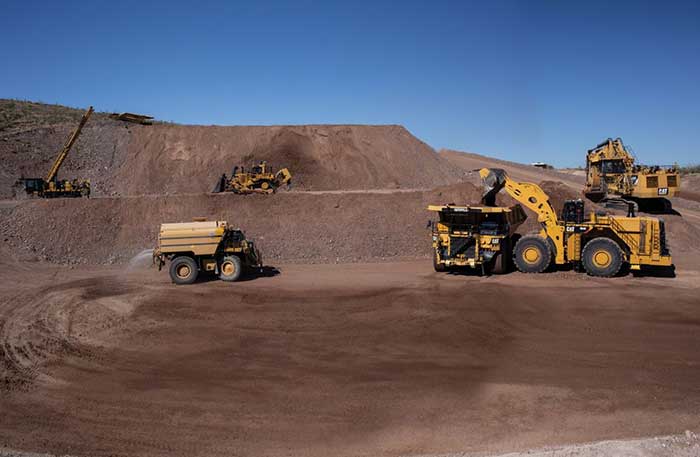
After years of testing and hype, not a lot of companies can say there are real applications for autonomous technology. However, at this year’s virtual CES 2021 trade show, both Caterpillar and John Deere, two companies known for their tractors and heavy equipment, showcased autonomous machines that are being used worldwide in farming and mining projects.
Photo: Caterpillar
Deerfield, Ill.-based Caterpillar, a first-time exhibitor at CES this year, said it has been involved in autonomy and use of GPS for more than two decades. “We were an early adopter of GPS when there were few satellites in the sky,” said Denise Johnson, company group president, resource industries. “We have 350 autonomous trucks operating 24-7 on three continents.”
The company’s autonomous vehicles, in addition to other technology, are being used around the clock in the Kearl Oil Sands project in Alberta, Canada.
“We are using autonomy primarily in mining operations in harsh environments. These [vehicles] are operating 24-7, with no loss time incidents,” said Bill Dears, Caterpillar worldwide sales and marketing manager. “We also track people underground with cameras and radar.”
In addition to production enhancement, safety is a factor in mining operations because of operator fatigue — something that is precluded by autonomous mining equipment, Dears said.
Agriculture uses variety of sensors, including GNSS
To Moline, Ill.-based John Deere, exhibiting at the trade show for the third time, agriculture is a high-tech industry that uses GPS, self-driving tractors, artificial intelligence and a multitude of sensors. The company rolled out its first self-driving tractors nearly 20 years ago, said Jahmy Hindman, John Deere CTO.
Photo: John Deere
The company won the CES Innovation Award for one of its tractor and combine product lines. “Both our planter and tractor have GPS and antennas to know where to drive and where exactly fertilizer [is to be placed],” Hindman said. “These tractors are self-propelled, with accuracy augmented with [real-time kinematic] sub-inch accuracy for the planters in a field.”
Among other requirements, Hindman said that tractors have to drive in a straight line, plant the required amount seeds and position them at the right depth. “When a tractor drives in a very straight line, the burden is off of the farmer. The yields increase—this is the way we see the progression of automation,” he said. “We are excited about 5G and its lower latency and high bandwidth. It opens up a lot of opportunity.”
Organizers roll out Indy Autonomous Challenge race car
At the virtual CES, representatives from the Indy Autonomous Challenge unveiled the Dallara IL-15 race car that will be used in a head-to-head race around the famous Indianapolis Motor Speedway on Oct. 23.
The Indy Autonomous Challenge, organized by Energy Systems Network and Indianapolis Motor Speedway, pits 500 university students, developing autonomous vehicle technology, against each other for a $1.5 million prize.
Logo: Indy Autonomous Challenge
Organizers say the speeds are estimated to be as much as 200 mph around the 2.5-mile track, for 20 laps, which enables researchers to evaluate how autonomous vehicle technology works in extreme conditions. They say that the goal of the race is to advance the implementation of autonomous vehicles and advanced driver-assistance systems (ADAS), much like the 2005 Defense Advanced Research Projects Agency (DARPA) Grand Challenge.
The race track has been the scene of much innovation throughout the years, said Doug Boles, Indianapolis Motor Speedway president. “Firestone tests tire technology there and that data transfers to our cars. One of the first conversations we had with Roger Penske [after Penske Entertainment bought the speedway] was about the autonomous challenge,” he said.
IAC sponsors include ADLINK, Ansys, Aptiv, AutonomouStuff, Bridgestone, CU-ICAR, Dallara, Indiana Economic Development Corp., Microsoft, New Eagle, PWR, RTI, Schaeffler and Valvoline.
Mobileye plans to test autonomous fleets in four cities
Intel subsidiary Mobileye plans to launch autonomous vehicle fleet testing in Detroit, Paris, Shanghai and Toyko. The announcement, made at CES by CEO Amnon Shashua, said that the company also plans to test in New York City, pending regulatory approval.
The company also plans to use in-house-built lidar sensors, while continuing to champion its camera-based testing. “We are using crowd-sourced data through the Cloud to build high-definition maps at scale,” Shashua said. “Thousands of product vehicles are sending us data.”
Shashua addressed a moderator’s question that cameras alone cannot be the technology of choice for autonomous vehicles. “The camera first is crucial from a technology and business point of view. We have to find out what is acceptable failure for Level 4 autonomy. Camera-only is ideal, but pushing the envelope for driver-assistance systems,” he said. “Consumer AV will take place in the 2025 timeframe. [Eventually], we can build lidar and radar to the same performance levels as camera systems. Lidar and radar can be added later for redundancy, but only for Level 4.”
Shashua said getting to Level 4 could take a decade, but that would be unsustainable unless there are government-funded projects to keep companies afloat. “By 2025, a subsystem will be good enough for consumers. Regulation is critical and sometimes it’s difficult to leap to a consumer level,” he said.
Not everyone believes what Mobileye is testing constitutes “driverless” status. To Alain Kornhauser Princeton University professor and transportation program director, who was head of the university’s team during the 2005 DARPA Challenge, not many companies are capable of full driverless capability.
“Unfortunately, I still see all of this as simply ‘eye candy’ to sell something that actually has no intention of delivering what it is implying. I still claim that the business case is zero, doesn’t exist, for personally-owned autonomous vehicles,” Kornhauser said in his Smart Driving Cars weekly newsletter. “Mobileye is nowhere close to being able to operate safely on most roads, let alone all roads. Thus, the consumer market has zero opportunity to scale.”
Kornhauser said that driverless testing is being conducted only in one place, Phoenix, by Waymo. “Neither Tesla nor Mobileye are driverless anywhere. They both require on-board human driver supervision,” he said. “That’s why they are only self-driving [tests].”
In other CES news:
GM CEO Mary Barra unveiled a single-seat electric vertical takeoff and landing (eVTOL) concept aircraft. The aircraft will be developed for future use as an air taxi. Barra briefly mentioned that the company’s Super Cruise self-driving technology will be integrated into 22 car models in a few years. The company also rolled out an electric vehicle for deliveries that can travel 250 miles on a charge and a motorized pallet for deliveries that can be tracked.
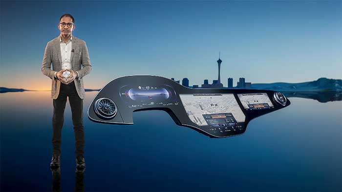
Photo: Mercedes-Benz
The Mercedes-Benz’ MBUX Hyperscreen, rolled out at CES, evaluates map data, surroundings and provides information about landmarks along a route, said Sajjad Khan, company CTO and member of the board of management. The new map feature, called Mercedes Travel Knowledge, allows a passenger or driver to ask a question as they drive by a landmark (“hey, Mercedes, what can you tell me about this building?”). The MBUX Hyperscreen is available in the new S-Class cars.
HERE Technologies introduced a mapping-as-a-service platform at CES. The platform is targeted to businesses wanting to create custom map datasets for advanced analytics and services, the company said. Some use cases include industrial yard mapping, leveraging probe data from private vehicle fleets in order to create or update a map.• A virtual CES is hard to get used to. After more than 20 years of covering the massive trade show in person, covering press conferences and conducting interviews online was sometimes a challenge. Sometimes the press conferences did not have question-and-answer sessions, or canned answers given to executives by public relations people. This doesn’t happen much during an in-person interview. In addition, trying to chat with “booth” personnel online was cumbersome and often those requests for information were ignored.
Cohda Wireless has partnered with u-blox to produce an advanced V2X solution for the global Cooperative Intelligent Transport market. With the partnership, Cohda’s V2X software stack will support the u-blox UBX-P3 DSRC/802.11p V2X chip.
Cohda Wireless and u-blox have a long-standing relationship and share a common vision of leveraging wireless technology to reduce the number of road accidents and fatalities across the globe.
The u-blox chip enables wireless vehicle-to-vehicle (V2V) and vehicle-to-infrastructure (V2I) communication, now enhanced with Cohda’s hardware-agnostic software applications.
Cohda said its software is widely deployed in the industry, providing 360° awareness and detecting hidden threats beyond anything a driver or on-board sensors can see.
Cohda Wireless Chief Engineer Fabien Cure said that the partnership offers the market an advanced V2X solution that will be of particular interest to Tier 1 auto makers, OEMs and road authority suppliers.
“In order to progress vehicle safety, OEMs need to produce vehicles that have embedded V2X wireless communication technology as a standard inclusion,” Cure explained. “Likewise, cities around the world are preparing for the introduction of wide scale cooperative intelligent transport systems.”
Cohda’s V2X software is in production vehicles of GM and Volkswagen.
“Connectedness is the key to safer roads and highways around the world and a technology solution of this calibre is an enabler of further trials and development in this sector that we warmly welcome,” added Mr Cure.
“The porting of Cohda’s leading V2X onto our high-performance UBX-P3 chip is an important proof point that both our solutions are interoperable and enable a swift integration into automotive platforms,” said Herbert Blaser, senior director, Product Center Short Range Radio at u-blox.
Cohda’s software products are applied in more than 60 percent of all V2X field trials in the world today in compliance with U.S. Federal Communications Commission and European Telecommunications Standards Institute (ETSI) standards.
“When we connect vehicles to each other and to roadside infrastructure, we are creating an intelligent and integrated road transport system that has the potential to reduce road accidents simply because the technology is capable of things humans aren’t,” added Cure.
After 2020, Super Cruise will will be available on all General Motors brands (Photo: GM)
Trimble has announced the availability of Trimble RTX Auto, a GNSS software library written for use in safety critical automotive applications.
The RTX Auto library can be integrated with any GNSS device and enables the decoding of Trimble’s RTX correction stream for centimeter-level absolute positioning accuracy, the company said.
RTX Auto works with other on-vehicle sensors to deliver a positioning solution that satisfies advanced driver assistance systems (ADAS) and autonomous driving requirements.
RTX Auto is both Automotive Safety Integrity Level (ASIL) and Automotive Software Process Improvement and Capability Determination (ASPICE) certified. These certifications validate that Trimble RTX Auto meets functional safety requirements for ADAS and autonomous applications in the auto industry.
“For over 35 years, Trimble has been at the forefront of positioning innovation, accelerating productivity for our users,” said Patricia Boothe, vice president of Trimble’s Advanced Positioning Division. “RTX Auto takes our technology leadership into functional safety applications and allows the automotive industry to leverage Trimble’s leading RTX correction technology. Trimble RTX technology is helping to safely accelerate vehicle autonomy, transforming how the world drives.”
While other correction service providers are validating their ADAS positioning products and services in test environments only, Trimble is on the road today providing RTX-based absolute positioning within General Motors’ Super Cruise, a hands-free driving system for the freeway.
General Motors (GM) is using Trimble RTX (real-time eXtended) technology as the high-accuracy GNSS/GPS correction source to deliver absolute positioning to vehicles equipped with GM’s Super Cruise hands-free highway driving system, now available on the 2018 Cadillac CT6.
GM customers using Super Cruise featuring Trimble RTX technology can have peace of mind on the road knowing that RTX plays an important role in maintaining lane position for hands-free driving on divided highways.
https://youtu.be/_rxW68ADldI
Super Cruise also uses precision lidar mapping data, a state-of-the-art driver attention system, and a network of camera and radar sensors.
Trimble RTX technology provides real-time, multi-constellation GNSS positioning capable of achieving better than 1.5 inches accuracy. Standard GPS signals can drift up to 25 feet, which could cause incorrect lane identification.
The 2018 Cadillac CT6 features Super Cruise hands-free driving technology for the highway. (Photo: GM)
Lane-level accuracy is a critical enabler in advanced driver assistance systems increasingly being used on highways. When used in conjunction with high-definition maps, cameras, radar and inertial sensors, Trimble RTX improves lane-level positioning performance for semi-autonomous and autonomous vehicles.
Trimble has a long history of pioneering automation and vehicle autonomy to improve productivity — from providing positioning solutions for some of the earliest robotic applications in the 1990s to delivering automated steering for farm tractors, automated blade control for earthmoving equipment and providing advanced positioning technology for fully autonomous trucks.
Trimble is now enabling semi-autonomous operations for passenger vehicles with Trimble RTX technology, delivering high-accuracy GNSS corrections via a global network to support absolute vehicle positioning in combination with other sensors and inertial dead-reckoning.
Trimble’s RTX technology uses signals captured by more than 100 Trimble GNSS reference stations around the globe. Trimble RTX corrects the signals for atmospheric conditions, satellite orbit and time synchronization errors and then sends those signals to GM vehicles with Super Cruise via OnStar 4G LTE cellular.
The Trimble network is supported by redundant servers that are monitored 24/7 by a team of network engineers and IT specialists ensuring optimal signal performance and reliability for drivers who will depend on it.
“Through our collaboration, the combined technologies of GM and Trimble will transform the way the world drives,” said Patricia Boothe, vice president of Trimble’s Advanced Positioning Division. “Trimble RTX is now influencing how we interact with our vehicles and the environment around them — helping to minimize driver fatigue and improve the assisted driving experience.”
General Motors’ self-driving unit Cruise Automation is applying to begin the first sustained testing of vehicles in fully autonomous mode in New York state — specifically in Manhattan — in early 2018.
“Autonomous vehicles have the potential to save time and save lives, and we are proud to be working with GM and Cruise on the future of this exciting new technology,” said New York State Governor Andrew Cuomo.
Testing in New York will accelerate the timeline to deploying self-driving cars at scale, according to Kyle Vogt, CEO of Cruise Automation. “New York City is one of the most densely populated places in the world and provides new opportunities to expose our software to unusual situations, which means we can improve our software at a much faster rate.”
GM is also doubling the size of its test fleet in San Francisco, California, from 30 to 100 as part of its effort to develop software capable of navigating congested and chaotic urban environments. GM has reported more run-ins between its self-driving cars and human-operated vehicles and bicycles. Its vehicles were involved in six minor crashes in September, all of which were caused by the other vehicle.
Lidar Acquisition. GM announced Oct. 9 that it has acquired lidar company Strobe. Strobe’s engineering staff joins GM’s Cruise Automation team to define and develop next-generation lidar solutions for self-driving vehicles. Lidar images provide a more accurate view of the world than cameras or radar alone, information needed by autonomous cars.
General Motors Co.’s (GM) self-driving unit, Cruise Automation, has more than doubled the size of its test fleet of robot cars in California during the past three months, a GM spokesman told Reuters.
The unit is testing vehicles in San Francisco as part of its effort to develop software capable of navigating congested and often chaotic urban environments.
GM has reported more run-ins between its self-driving cars and human-operated vehicles and bicycles. Its vehicles were involved in six minor crashes in September, all of which were caused by the other vehicle.
In the past three months, the Cruise unit has increased the number of vehicles registered for testing on California streets to 100 from the previous 30 to 40.
Lidar acquisition. GM announced Oct. 9 that it hasacquired lidar technology company Strobe. Strobe’s engineering talent joins GM’s Cruise Automation team to define and develop next-generation lidar solutions for self-driving vehicles.
In September, Cruise Automation revealed the world’s first mass-producible car designed with the redundancy and safety requirements necessary to operate without a driver. The vehicle will join Cruise’s testing fleets in San Francisco, metropolitan Phoenix and Detroit.
Lidar uses light to create high-resolution images that provide a more accurate view of the world than cameras or radar alone. As self-driving technology continues to evolve, lidar’s accuracy will play a critical role in its deployment.
Mobileye, a developer of vision and data analysis for Advanced Driver Assistance Systems (ADAS) and autonomous driving, has introduced a new mapping technology development called Road Experience Management (REM).
REM enables crowd-sourced real-time data for precise localization and high-definition lane data that forms an important layer of information to support fully autonomous driving.
Mobileye is engaged with General Motors to integrate REM into existing program launches in an expedited timeframe, as part of GM’s heightened partnership with Mobileye. In addition, on Jan. 5, Mobileye signed a Memorandum of Understanding with Volkswagen and announced a strategic partnership to explore and integrate REM into Volkswagen’s fleet.
The technology is based on software running on Mobileye’s EyeQ processing platforms that extracts landmarks and roadway information at extremely low bandwidths, approximately 10 kb per kilometer of driving. Additionally, backend software running on the cloud integrates the segments of data sent by all vehicles with the on-board software into a global map.
“We leveraged advanced artificial intelligence, used for creating environmental models from camera input, in order to create maps based on local coordinate systems while requiring very low bandwidth,” said Prof. Amnon Shashua, co-founder, chairman and Chief Technology Officer of Mobileye. “The low bandwidth of the model, and the fact that it requires only a camera, which is already available in most new car models as part of the trend towards growing driver assistance deployment, enables the map creation and update to be managed by a cooperative crowd sourcing mechanism.”
A third OEM customer of comparable size is expected to be announced later this year.
Shashua discussed the future of autonomous driving and road mapping at the Consumer Electronics Show in Las Vegas in January.
When comedian Larry Wilmore started out Day 2 at CTIA Super Mobility Week by reporting from a connected car on the show floor, he was only half joking when he said, “It’s almost like you’re driving in a smart phone, and with smart phones getting bigger it’s not too far off. I think I saw an HTC this size.”
The experts in the keynote Connected Car panel agreed: The car is the new smart phone.
Just ask Ralph de la Vega, CEO of the just-formed AT&T Mobile and Business Solutions Group, who called the Chevy Corvette “the best smart phone I’ve ever gotten to test.” The Corvette was conveniently displayed next to the stage, along with a connected Tesla Model S.
As CTIA CEO Meredith Atwell Baker pointed out, what was once relegated to the CTIA show floor is now in dealerships all across the U.S. The statistics thrown out by de la Vega supported this observation. Thirty-two percent of new cars sold globally (and 60% of new cars sold in the U.S.) by 2017 will be embedded with cellular technology. Seventy-two percent of people would delay a new car purchase one year to buy a connected car by their preferred automaker.
De la Vega co-moderated the panel with Glenn Lurie, his successor as CEO of AT&T Mobility. Panelists representing General Motors/OnStar, Ericsson, VoiceBox and Tesla overwhelmingly agreed that the emphasis on the connected car going forward has to be safety.
“[Drivers are] trying to fill the time and be productive. People naturally want to do that. They’re going to bring the phone in, reach over, grab it and try to do things. And the more capabilities, the more they’ll do it,” said Mike Kennewick, co-founder & CEO of VoiceBox, maker of natural language technology. “It’s imperative as we bring the Internet into the car, there’s a component that allows you to do it safely.”
What that would mean, exactly, though, was a matter of opinion. Each panelist had a chance to discuss their company’s recent and coming advancements.
De la Vega says AT&T’s studies show people prefer a shared family data plan that would allos them to share data across people and across devices, and a belief by the wireless provider that customers should be able to add their cars to their rate plans.
GM has successfully integrated 4G/LTE into 33 different models in the U.S. and Canada and next plans expansion in Europe, Mary Chan, President of Global Connected Consumer at GM shared.
VoiceBox’s Kennewick calls the voice recognition in cars today “just like the movies” but says VoiceBox strives to simplify the apps in cars and make voice activation less about reiterative command-and-control.
Telsa, a leader in over-the-air auto updates, will be launching a mass market car “in a few years” and is now exploring how best to keep the customer experience focused in the car. Tesla CIO Jay Vijayan also said the company is considering opening up its infotainment stystem to other partners.
The highest court in the European Union has granted the right to be forgotten by a search engine. Will location privacy be next on the docket? We are seeing the beginnings of the in-car smartphone-type apps market and are watching for approaching hockey-stick style growth that is a year or two away. Google has added rich, engaging features to maps. And we take a look at results from indoor location advertising. Read more.
The European Court (EU) of Justice, made a curious and powerful ruling on privacy. The court stated that upon request, Google is obliged to remove reputation-hurting information that is generated by searching a person’s name. Like Mr. González, who brought this case to court, many of us have things in our distant past that we don’t want to be aired each time we are Googled. Perhaps it is an old bankruptcy or a youthful prank gone bad. The continuous re-airing of this information can make it hard for people to move forward in their lives. But while the court rule serves a purpose, it is poorly conceived and vague. The administrative complexity for search engines to comply is staggeringly onerous. And the information that it seeks to shield will still reside in websites.
How does this relate to location privacy? The EU Court of Justice is in the mood for privacy restrictions, and the use and handling of location data may be in their scopes. Also, sensitive location information can turn up in Google searches. A person in the EU will be able to request to have it shielded. Location information can be revealing. There may be records of check-ins from the café outside a rehab center or other treatment center, for instance.
Market, Fast Approaching. Companies are falling over each other for a piece of a new market about to burst open — software apps within vehicles. Analysts at IHS Automotive expect there will be 370 million smartphone apps for cars in use by 2020, a hefty growth from the 6.9 million units projected by the end of this year. Aha Radio is in Honda cars. General Motors is embedding Pandora, the music streaming app. 4G Internet connectivity will be in some GM and Audi models next year. BMW is opening app stores, this year in Europe and next year in the U.S.
The Players. Google and Apple (Google Projected Mode and Apple CarPlay) are poised to together dominate the market for auto apps integration, but other companies are in pursuit as well, including MirrorLink, Aha by Harman, and Ford Sync AppLink. North America is ahead of the global rush. Let’s hope some money flows into Detroit.
Google v. Apple. Information about Googles’ Projected Mode is scarce. Daimler posted an ad for a software engineer to help implement Google’s new in-car system, referred to as “Google Projected Mode.” The employment ad described Project Mode as a way to “seamlessly integrate” Android smartphones into a dashboard’s head unit. There is no mystery about Apple’s CarPlay, an extension of IOS. CarPlay simplifies the in-car experience by offering the same look and feel as an iPhone.
GM Pulls Ahead. Ford was the early automotive leader to offer smartphone-type apps with its Sync system, but more recent versions of the offering have had issues. They weren’t alone. Other car makers have had confusing interfaces that often contained annoying bugs. IHS now predicts that vehicle OEM adoption and integration will be led by General Motors. “Apps for autos are growing rapidly and will have a profound impact on auto infotainment and connectivity in the next decade,” said Egil Juliussen of IHS Automotive. “Auto apps will influence the competitive landscape among auto manufacturers and will even change the brand market share between them. OEMs will have to keep up to remain competitive.”
Better Google Maps. Google’s navigation system will now offer less congested or otherwise quicker routes during navigation, a byproduct of Google’s purchase of Waze. In addition, the navigation system will now advise on the best traffic lane, replacing less precise directions such as “keep left at the fork.” Google has partnered with cab provider Uber to show how long it would take to get home via cab when searching for public transit or walking directions. Google maps also now enable users to save entire cities for offline use.
Indoor Location Pays? In order for retailers to adopt indoor location technology, there needs to be clear returns. “A body of information is now gathering that verifies the effectiveness of these technologies,” reports Dominque Bonte of ABI Research. “We can see how limited trials are showing increases of advertising local search click-through rates from 0.1 to 3.5 percent, indoor location applications increasing basket sizes 10 percent, and how smartphones are significantly changing the cross channel shopping habits of users.”
Not everyone is talking up the accuracy of indoor positioning. Arlington, Virginia-based Telecommunications Industry Association says the technology, which is seen as the one way location-based services providers will be able to capture consumer interest, is not ready. In other LBS news, AT&T has come out with data pricing for its connected vehicle initiatives.
In a recent FCC filing, the Telecommunications Industry Association said that indoor positioning technology is not sufficiently developed to support ongoing wireless E-911 location accuracy requirements.
While TIA supports the FCC’s goal to improve location accuracy, “Imposing location accuracy mandates at this time would be premature, given the nascent stage of the technology that will be needed to accomplish the Commission’s objectives, and should neither favor nor disfavor specific technologies,” said the association in its filing.
The NPRM proposes a requirement to achieve “rough” indoor location information, TIA said. It proposes to require providers to provide horizontal information for wireless 911 calls that originate indoors, specifically a caller’s location within 50 meters.
TIA also disagrees with an FCC proposal to require mobile operators to provide z-axis, which is vertical location within 3 meters of a caller’s location, for 67 percent and 80 percent of indoor wireless 911 calls — ranging from three to five years after adoption. Again, TIA says that the technology is not fully developed.
TIA quoted AT&T’s filing: “[The] time [is] right to begin discussing Indoor Location Accuracy for E-911” but the “FCC should be careful to ensure that any proposed rules on location accuracy are aligned with proven capabilities of the current state of technology and they should set realistic accuracy benchmarks that the industry and public safety can embrace.”
The location industry has been counting on indoor positioning, with its beacons and Wi-Fi enhancements, to jump-start a location-based services market that always seems to have tremendous potential, but the numbers don’t back it up. Some big-time analysts have said that while the promise of indoor positioning is huge, it just isn’t there technically yet.
In fact, one analyst said that the biggest technological breakthrough last year was indoor mapping. Such major retailers as Home Depot and Lowes launched indoor maps with product search locators. These same analysts say that indoor Wi-Fi positioning is not accurate enough for macro location.
The big deal coming up is how FCC positioning accuracy regulations will affect beacons or Bluetooth low energy for micro location and proximity services.
TIA said it supports initial FCC location accuracy requirements back to 2007. However, don’t ask TIA for more location regulation. “To date, the development of 911 and E911 location accuracy technologies and applications has been fostered by a voluntary and consensus-based standards process. This process has proven quite successful to date, and the Commission should refrain from imposing regulations that could slow additional development,” the association said.
AT&T Announces Connected Car Pricing
AT&T Mobility said standalone pricing for new LTE-enabled OnStar service will be $5 or $10 per month, depending on whether the driver is an OnStar subscriber. The company said it will allow customers, with a GM LTE-capable vehicle, to add the car as another device for $10 — which is the same price as a tablet.
OnStar subscribers will get coverage ranging from $5 for 200 MB of data per month to $50 for 5 GB. GM is also allowing customers to buy one-time data packages.
At this year’s CES, General Motors announced its first LTE-enabled vehicles — in which AT&T Mobility is powering the LTE network for GM’s OnStar service. The first LTE-enabled vehicles, which will be available this summer, are Impala, Spark, Volt, Orlando, Spark RV, Silverado, Silverado HD, Malibu, Equinox and Corvette Stingray. GM plans to have 30 Chevrolet, Buick, GMC and Cadillac vehicles LTE-equipped by the end of the year.
AT&T also made recent deals to provide connectivity for Ericsson Connected Vehicle Cloud which connects to the AT&T Drive platform for automakers.
CEA Hosts CES on the Hill
Members of Congress and their staff had the opportunity to observe location technology during the Consumer Electronics Association’s recent CES on the Hill event in Washington. Exhibiting companies include Origo Safe, distracted driving; AT&T Drive; DashIt; Qualcomm, which showed off a geofencing product around schools; and RideScout.
Washington-based Ridescout is a cool, and free, mobile app that allows a user to find the nearest subway, bus, taxi, bikeshare, sedan service, carshare, pedi-cab or carpool. A user can choose from a list of options by proximity, cost or arrival time.
“We launched in November in Washington, D.C. We are in Austin, San Francisco, Boston, Chicago and planning several new markets,” said Steve Carroll, Ridescout vice president of operations.
The app, which is on the iOS and Android platforms, generates revenue by sharing with the ride providers, large organizations and universities and the public transport network, Carroll said.
Some of Ridescout’s partners include Mozio, RidePost, Metro of Washington, Bandwagon, Sidecar, Car2Go, Arlington Transit, Capital Bikeshare, Yellow Cab, DC Circulator and Dash.
RideScout, founded by two Army veterans, was hatched when founder and CEO Joseph Kopser wanted an application to show him the best way to get to work in the Washington area. He could not find one and started the company with Craig Cummings. The company initially launched an alpha product at South by Southwest in 2013.
Though it was the first to combine all modes of transportation in a single application, the company has some competition. Of course this competition is from the 800-pound location gorilla, Google.
Google, with its Google Maps platform, shows the directions to the nearest transportation mode. Now it is incorporating Uber, which is an on-demand transportation provider.
This is not the first time Google has launched a product in an effort to dominate a market place or niche. When it launched Google Maps in 2009, it put the hurt on many companies in the location industry, which underwent a three-year period of consolidation, company closings and layoffs.
It’s a trifecta. The most interesting news at CES, Mobile World Congress, and now CTIA was the connected vehicle. Last week at CTIA, the biggest mobile conference in the U.S., GM and OnStar demonstrated ideas of what we can expect in vehicles once AT&T’s LTE network makes its way into vehicles. We heard about many of their concepts in February at Mobile World, but with the infotainment possibilities being shown at CTIA, it is clear the endeavor is evolving quickly. Providers of navigation, mapping, traffic, middleware, search, points of interest and mobile advertising have key roles. We’ll check in ahead with some of these companies.
GM and OnStar envision an in-vehicle curated app ecosystem with downloadable apps and remote vehicle management. Developers will have access to APIs that can access the vehicle’s speed, performance, GPS, fuel economy and other information, but are kept out of areas that could cause safety issues. GM, as well as other OEMs, is not ready to let the app marketplace take money out of its pocket. The automaker is pushing to get apps built specially for its vehicles. Mary Chan of GM said that the business model hasn’t been decided, but the apps may be free, bundled into a service that GM charges for, or paid out to the developers. Another possibility is an app subscription paid for on a smartphone could be applied to a separate app in the car. We have to wait until model year 2015 to see it come off the assembly line.
Snippets heard at CTIA:
“The biggest challenge of indoor location is having a good enough return on investment by the venue.” Derek Peterson, Boingo
“We hear many pitches from companies that want to supply us with indoor location technology, but so many of them are just unscalable.” David Hildebrandt, ATT
“Relevant, connected car data trumps free.” Mary Chan, General Motors
“The future killer mobile apps are banking, retail, medical (records, diagnosis) and government (voting, administrative).” Michael Saylor, MircoStrategy
“The ownership of data in connected cars will be a huge issue. And what happens to data in a vehicle when you transfer ownership?” Mary Chan, General Motors
Traffic Information Is Getting Better. Traffic information is getting more granular, hence more useful. INRIX and others are collecting traffic data in road segments about 250 meters long, a significant improvement from the past. Not too long ago, traffic data was provided solely by sensors, cameras and helicopters, which covered only highways and some arterial roads. The use of crowd-sourced traffic data now provides a leap in the amount of traffic data collected, enabling more current traffic conditions, as well more roads, to be monitored. “We can collect traffic data for these small road segments from all sources, crunch it and turn it around in under a minute,” says Bill Schwebel of INRIX.
How Fast? In a few years, Schwebel says we will see an expansion of navigation that goes beyond driving from point A to point B. This would include accurate estimates of the entire length of your trip, for instance, driving from your home to arriving at your airport gate. “We will be getting more feeds from parking lots with electronic counters, but we can also see the dwell time in a parking lot, or cars that exit without parking, all from crowdsourcing,” adds Schwebel. Waits at TSA lines or rental car counters can be devised using historical and near real-time data. When schedules of events in the area and school calendars are added, the predictions get better.
Navigation Changes Ahead. Turn-by-turn navigation will take a step forward to becoming more interactive when it becomes a two-way broadcast. Niall Berkery of Telenav, predicts that two-way connected navigation will appear in 2014-2016. “We are now focused on reducing the complexity of navigation and making it more personalized,” says Berkery. The entire industry, hindered by the perspective that navigation is free, is focusing on adding value. Telenav acquired ThinkNear to add hyperlocal marketing to its offering.
Embedded Navigation and the Delivery Man. Berkery estimates that 30% of navigation systems are embedded in the vehicle, which can makes updating or servicing the devices challenging. Some years ago an interesting solution was developed in China. When an embedded navigation system needed servicing, it was handled by a package delivery service, similar to FedEx. The delivery person manually removed the navigation hard drive from a consumer’s vehicle and sent it off to be fixed or replaced. When the drive came back from the factory, the package delivery person reinstalled it. That’s pretty special service.
If you missed last week’s CTIA show, held May 21-23 in Las Vegas, you will have to wait a year and a half for its next appearance. With CES and the Mobile World Congress positioned on the calendar prior to CTIA, the other shows drew the lion’s share of product announcements and crowds. CTIA will reposition itself in front of these competing shows. CTIA’s new “Super Mobility Week” will be more international and take the place of the current fall and spring CTIA shows. Super Mobility Week will be held Sept 9-11, 2014 in Las Vegas and will include MobileCON and other major partnerships to create a bigger show experience.