The Quanta Micro inertial navigation system (INS) has been named a finalist for the AUVSI XCELLENCE Awards — “Enabling Components & Peripherals.” The winners will be announced during an awards ceremony at AUVSI XPONENTIAL 2023 at the Colorado Convention Center in Denver.
The AUVSI XCELLENCE Awards honor innovators who demonstrate commitment to advancing technology, leading and promoting safe operations and developing programs that use unmanned systems to improve the human conditions.
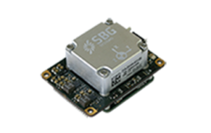
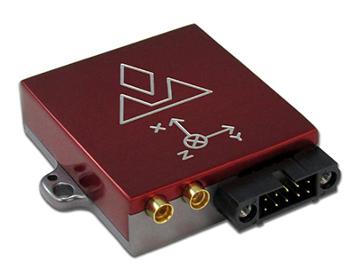
Quanta Micro is a GNSS-aided INS designed for space-constrained applications. Quanta Micro leverages a survey-grade inertial measurement unit (IMU) for heading performance in single antenna applications, and temperature calibration from -40° C to +85° C. An optional secondary antenna enables fast heading initialization in low dynamic applications.
“This year, XPONENTIAL is all about designing a shared plan for the future of autonomy,” Brian Wynne, president and CEO of AUVSI, said. “There’s no better place to announce the 2023 XCELLENCE award finalists.”
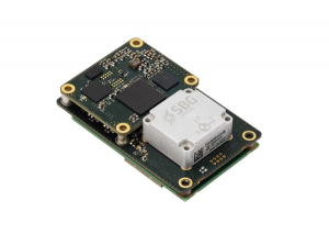
SBG Systems has released Quanta Plus, a GNSS-aided inertial navigation system (INS). Quanta Plus is a small, lightweight product, which can be easily integrated into survey systems with lidar or other third-party sensors.
The device combines a micro-electromechanical (MEMS) inertial measurement unit (IMU) with a resilient GNSS receiver to get reliable position and attitude, providing real-time kinematic (RTK) fixes.
Quanta Plus includes motion profiles, which enable users to optimize the sensor parameters to suit different use cases. The built-in precise time protocol server ensures sub-microsecond synchronization with external devices such as lidar. The device also has a built-in datalogger, Ethernet interface for easy integration, and a web configuration interface for simple setup and control.
The INS can be integrated with Qinertia, SBG System’s post-processing software. Qinertia improves the performance of acquired data during a mission using reliable RTK corrections from a wide range of continuously operating reference station networks, or by importing base-station data during the process.
Quanta Plus also improves the accuracy of the position and attitude using forward and backward processing and by integrating a tight coupling between GNSS and IMU data.
Quanta Plus is suitable for survey professionals or a navigation-dependent company seeking a robust navigation device. Specific solutions are available for integrators and OEMs who want to use Qinertia as a component in their application-specific data-processing solutions.
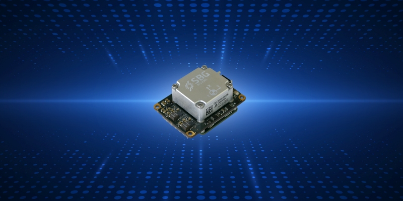
SBG Systems has announced a new inertial navigation system (INS) named Quanta Micro, completing its Quanta product line.
The Quanta Micro GNSS-aided INS offers a unique combination of navigation performance and low size, weight, power and cost (SWAP-C).
Quanta Micro leverages a survey-grade inertial measurement unit (IMU) for optimal heading performance in single antenna applications, and high immunity to vibrating environments. An optional secondary antenna enables fast heading initialization in low dynamic applications.
Main Features
Accuracy: 0.015° roll/pitch, 0.035° heading, 1 cm position (PPK)
Integrates a survey-grade IMU: 0.8°/h gyro bias instability
Versatile INS/GNSS to suit land, air or marine applications
Highly tested and calibrated from -40°C to 85°C
Robust to vibrating environments
Quad-constellation multi-band RTK GNSS receiver
Smooth post-processing workflow with Qinertia software
Major size reduction with no compromise on performance.
MEMS-based sensing solutions company Acienna released OpenIMU, a professionally supported, open-source GPS/GNSS-aided inertial navigation software stack for low-cost precise navigation applications.
Integrating an inertial measurement unit (IMU)-based sensor network will greatly improve its navigation and self-location capabilities, Acienna said.
It is aimed at developing autonomously guided vehicles for industrial applications, autonomous cars, factory or industrial robots, drones, remotely operated underwater vehicle or any kind of smart machine that needs to move fast or slow, on land, in the air or in water.
“Our breakthrough open-source software for INS/GPS algorithm development is the first professional grade open-source navigation stack running on a low-cost IMU,” said Mike Horton, CTO of Aceinna. “Not only will this kit save developers time and money, it is simple to use and does not require a Ph.D.”
OpenIMU enables advanced, easy-to-deploy localization and navigation algorithm solutions for a fraction of the time and cost of traditional methods, Aceinna said.
OpenIMU’s combination of open-source software and low-cost hardware enables rapid development of advanced solutions for drones, robotics, and autonomous applications. Its extensible software-infrastructure provides all the code needed for algorithm development.
The freely downloadable stack includes:
FreeRTOS-based data collection and sampling engine
Free IDE/compiler tool chain based on Visual Studio Code
JTAG debugging for debugging code loaded on IMU
Data logging, graphing, Allen Variance plots and maps
Extensive documentation
Robust simulation environment with advanced sensor error models
To install OpenIMU stack now, follow the directions. Several ready-to-install free GPS/INS and IMU applications are available at Aceinna’s Navigation app store.
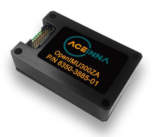
The OpenIMU Development hardware development kit includes JTAG-pod, precision mount fixture, EVB and an OpenIMU300 module.
The OpenIMU module features Aceinna’s 5 deg/Hr, 9-Axis gyro, accelerometer, and magnetometer sensor suite with an onboard 180-MHz ARM Coretex floating-point CPU.
The IMU is delivered in a 24 x 37 x 9.5 millimeter module that operates at 2.7-5.5 VDC.
The OpenIMU Development kit is available for immediate delivery.
Red Bull Air Race has selected the VectorNav VN-300 dual-antenna GNSS-aided inertial navigation system (INS) as its primary source of aircraft telemetry data for Master Class raceplanes participating in the Red Bull Air Race World Championship.
Weighing less than 30 grams, the VectorNav VN-300 is a tiny dual-antenna GNSS-aided INS. It is used in applications ranging from autonomous vehicles to antenna pointing for satellite communication and aerial surveillance applications.
The inaugural event of the 2018 season in Abu Dhabi saw the VN-300, manufactured by VectorNav Technologies, used for the first time in all 14 aircraft to provide real-time telemetry data used for judging, in-race simulation and virtual reality applications.
Created in 2003, the world championship has held more than 80 races around the globe. The motorsport competition combines speed, precision and skill.
U.S. pilot Michael Goulian performs during the finals at the first round of the Red Bull Air Race World Championship in Abu Dhabi on Feb. 3.(Photo: Andreas Langreiter, Red Bull Content Pool)
Using the fastest, most agile, lightweight racing planes, pilots hit speeds of 370 km/h while enduring forces of up to 10 G as they navigate a low-level slalom track marked by 25-meter-high, air-filled pylons. Pilots incur time penalties for hitting pylons, incorrectly passing through air gates or only exceeding 10 G for more than 0.6 seconds, among others.
Being an individual sport, spectators need a reference to see the difference between the pilots’ lines and speed through the racetrack. Red Bull Air Race Live TV uses an augmented reality (AR) solution known as the Ghost Plane to display the trajectory of the pilots’ runs for real-time comparison in the head-to-head rounds and the Final 4 that decides the winner of the race by time.
The Ghost Plane is driven by the position, velocity and attitude data gathered during flight from the onboard INS.
Critical to the success of the Ghost Plane is the accuracy of the telemetry data, which, given the high dynamics experienced during flight, is extremely difficult to obtain.
For example, as a plane races through a chicane and into a vertical turn maneuver, GPS signals are lost and the INS needs to rely solely on the inertial sensors to accurately estimate the position and velocity until GPS is fixed again in level flight.
The VectorNav VN-300. (Photo: VectorNav)
“We evaluated several different inertial navigation systems and struggled to find one that was able to perform in our dynamics,” said Alvaro Navas, sport technical manager for the Red Bull Air Race. “VectorNav’s VN-300 was the only product able to deliver the attitude, position and velocity data accuracy we require, and it did this out of the box, no customization was required. The sensor is really amazing.”
“We are really excited to be working with Red Bull Air Race,” said Gordon Hain, VectorNav product manager. “Not only are we able to provide accurate data for the race judges and spectators, but we are also able to provide valuable information to pilots and tacticians. With the VectorNav data in hand, they are able to compare actual flight trajectories with their simulations to find areas for improvement. We are looking forward to continued work with Red Bull Air Race in the 2018 season and beyond.”