Tag: GNSS backup

  • Launchpad: GNSS modules, 3D scanning, parking assistance

    Launchpad: GNSS modules, 3D scanning, parking assistance

    A roundup of recent products in the GNSS and inertial positioning industry from the August 2022 issue of GPS World magazine.


    OEM

    Receiver Module

    Designed for autonomous applications

    Photo: Trimble
    Photo: Trimble

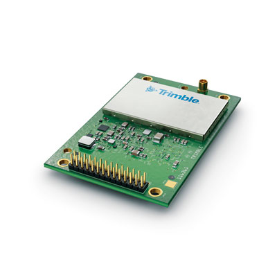
    The Trimble BD9250 dual-frequency receiver module supports Trimble RTX correction services and is designed to deliver high-accuracy positioning for high-volume, autonomous-ready applications in agriculture, construction, robotics and logistics. The compact receiver has an industry-standard form factor and pinout, allowing for easy system integration and configuration. Equipped with Trimble’s advanced ProPoint positioning engine, the BD9250 delivers robust and accurate positioning. It is compatible with Trimble RTX correction services or real-time kinematic (RTK) and supports GPS, Galileo, GLONASS and BeiDou as well as QZSS and NavIC. Support for the Indian NavIC S-Band signal is also available.

    Trimble, trimble.com

    GNSS Receiver

    For construction, mining and machine control

    Photo: Septentrio
    Photo: Septentrio

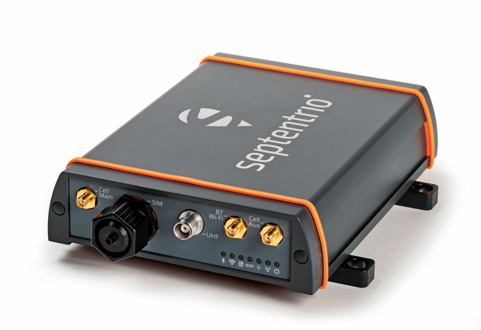
    The AsteRx-U3 ruggedized GNSS receiver is the successor to the AsteRx-U for construction, mining and other machine control applications. It combines a triple-band precise positioning GNSS core with extended wireless communication features including Wi-Fi, UHF and 4G LTE, making it easy to fit it into any control system. The AsteRx-U3 offers low latency of under 10 msec with a high data rate, which allows machines to work rapidly and accurately. An IP68-rated housing, with fixing brackets and robust M12 connectors, enables quick installation.

    Septentrio, septentrio.com

    GNSS Module

    Incorporates MediaTek flash chip

    Photo: Antenova
    Photo: Antenova

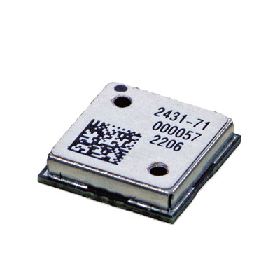
    The M20071 integrated GNSS receiver module, measuring 9 x 9 x 1.8 mm, incorporates the MediaTek AG3335MN flash chip. The receiver tracks four GNSS constellations concurrently (GPS + Galileo + GLONASS + BeiDou). The 1.8-volt system power supply provides outstanding low power consumption. Its multipath algorithms improve position accuracy in inner-city environments. The onboard low noise amplifier provides good performance in weak signal environments such as wearable devices.

    Antenova, antenova.com; MediaTek, mediatek.com

    M-Code Receiver

    For guided weapons and other small applications

    Photo: BAE Systems
    Photo: BAE Systems

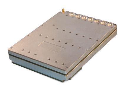
    The Strategic Anti-jam Beamforming Receiver – M-Code (SABR-M) enables precise geolocation and strike capabilities in highly contested battlespaces. It integrates receiver technology with advanced antenna electronics in a small, hardened package designed to meet challenging performance requirements. It delivers accurate position, velocity, altitude and timing data, as well as strong protection against GPS signal jamming and spoofing. At 4.5 x 6 x 1 inches, the SABR-M meets size, weight, power, cost (SWaP-C) and thermal requirements for space-constrained military applications. It uses advanced beamforming technology to improve GPS signal reception and counter threat signals.

    BAE Systems, baesystems.com


    TIMING

    Anti-Jamming Kit

    Protects against timing threats

    Photo: Focus Telecom
    Photo: Focus Telecom

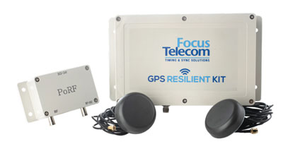
    The GPS Resilient Kit (GRK) is a cybersecurity device that comes with two antennas for monitoring and protecting time-critical infrastructures. It can be integrated with any GNSS receiver, either as a retrofit or in greenfield deployment. The GRK features a proprietary interference filtering algorithm for maximum protection, up to 40-dB attenuation of jamming signals with the premium option. It requires minimal power consumption while providing cloud-based monitoring with real-time reporting of jamming attacks. It protects GPS L1 (C/A code) with a latency of 100 ns ±15 ns (fixed).

    Focus Telecom, www.pnt-security.com

    GNSS Backup

    GBaaS enables providers to combat PNT cyberattacks

    Photo: ADVA
    Photo: ADVA

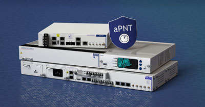
    GNSS-backup-as-a-service (GBaaS) enables service providers to help operators safeguard services that rely on positioning, navigation and timing (PNT). In-network timing based on network time protocols (NTP) and precision time protocols (PTP) are also increasingly vulnerable to cyber threats. GBaas is based on ADVA’s aPNT+ platform, which leverages a suite of technologies, including multi-band GNSS receivers and management software based on artificial intelligence and machine-learning. Service providers can offer ADVA’s aPNT+ protection as a subscription-based service as part of their service-level agreements.

    ADVA, adva.com


    SURVEYING

    GNSS Receiver

    Can be used as base station or rover

    Photo: CHC Navigation
    Photo: CHC Navigation

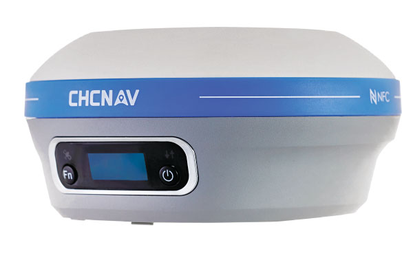
    The i73+ pocket-sized receiver is a powerful and versatile receiver with an integrated UHF modem that delivers survey-grade accuracy in all jobsite configurations. It has 624 GNSS channels and the latest iStar technology and can be operated as either a base station or a rover. The i73+ is a highly productive NTRIP rover when used with a handheld controller or tablet and connected to a GNSS RTK network via CHCNAV LandStar field software. The receiver takes advantage of GPS, GLONASS, Galileo and BeiDou, in particular the latest BeiDou 3 signal, to provide robust data quality at all times.

    CHC Navigation, chcnav.com

    GNSS Receiver

    Flexible accuracy-level options

    Photo: Juniper Systems
    Photo: Juniper Systems

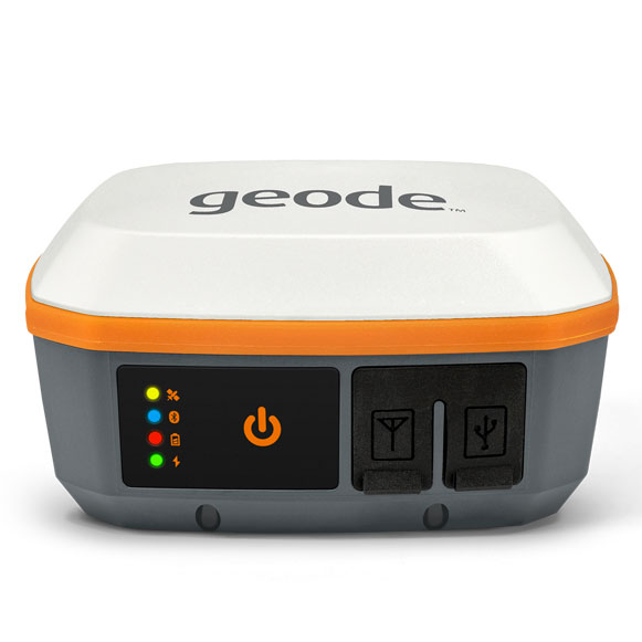
    The Geode GNS3 GNSS receiver allows users to collect real-time GNSS data with sub-meter, sub-foot and decimeter accuracy options. With a scalable accuracy platform, users can purchase what they need now, while having the option to increase accuracy in the future. It offers sub-meter accuracy with a single-frequency antenna, while its multi-frequency antenna supports all constellations on L1, L2 and L5. Atlas L-band corrections allow the Geode to be used in water utility locating, agriculture and irrigation mapping, as well as mapping projects in remote locations where other correction services are not available. The Geode GNS3 can be used with Windows, Android, iPhone and iPad devices.

    Juniper Systems, junipersys.com


    MAPPING

    4K Attachment

    Improved colorization to contextualize point clouds

    Photo: GeoSLAM
    Photo: GeoSLAM

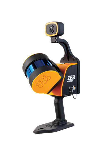
    The ZEB Vision is a camera accessory for the ZEB Horizon system that can be used to capture 360° panoramic photography in 4K definition for point cloud colorization. Data is captured as the user walks through the area of interest. The ZEB Vision uses GeoSLAM’s SLAM algorithm to automatically and accurately position panoramic photos on a point cloud for an interactive viewing experience. The ZEB Vision attaches easily to the ZEB Horizon. The 4K resolution increases feature definition of objects within the point cloud, allowing for a new perspective on data by navigating within a virtual representation of an environment. This means industries such as architecture, construction and facilities can add real-world context to point clouds for the creation of CAD/BIM models.

    GeoSLAM, geoslam.com

    Lidar sensor

    Improves bathymetric lidar surveys

    Photo: Leica Geosystems
    Photo: Leica Geosystems

    The Leica Chiroptera-5 is a high-performance airborne bathymetric lidar sensor for coastal and inland water surveys. It combines airborne bathymetric and topographic lidar sensors with a four-band camera to collect seamless data from the seabed to land. Compared to previous models, the Chiroptera-5 provides 40% higher point density, a 20% increase in water-depth penetration, and improved topographic sensitivity for generating more detailed hydrographic maps. Its high-resolution lidar data supports nautical charting, coastal infrastructure planning, environmental monitoring and landslide and erosion risk assessments.

    Leica Geosystems, leica-geosystems.com

    Visualization Software

    For field data capture and collaboration

    Photo: Clirio
    Photo: Clirio

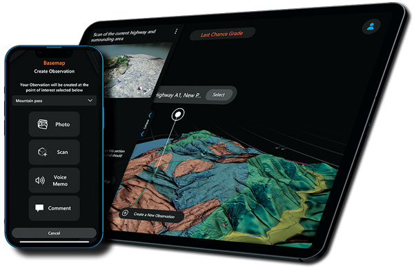
    The Clirio application combines mobile lidar 3D scanning with smart remote collaboration tools to offer teams an end-to-end 3D solution to capture, organize, share and problem-solve. This is all based on real-time field observations and data, whether team members are on site or a continent away. Clirio is a set of mobile, web and VR/AR apps for instantly capturing, sharing, reviewing and resolving worksite field observations. At a field site, Clirio users collect notes, photos and 3D scans (using the laser scanner built into a new iPad Pro or iPhone Pro). These field observations are automatically geo-referenced within the map-based workspace and synced to a secure cloud workspace. An intuitive interface allows colleagues, managers, partners, or stakeholders to sort, review, compare, and act on field observations.

    Clirio, www.clir.io


    TRANSPORTATION

    Parking Assist

    Designed to meet scooter parking challenges

    Photo: Bird
    Photo: Bird

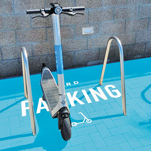
    The Visual Parking System (VPS) by Bird is designed to keep track of scooter parking in a scalable, efficient and vandalism-immune way that requires zero infrastructure within a community. Powered by Google’s ARCore Geospatial API, VPS enables scooter parking with pinpoint accuracy. When parking a scooter, riders will be prompted to take a quick scan of their surroundings. The system seamlessly compares a rider’s images against Google’s data and Street View images in real time to produce the best available parking solution. Stationary objects such as buildings and signs are used as reference points, while more dynamic objects such as people and vehicles are disregarded. The near-instantaneous process results in a precise, centimeter-level geolocation that enables Bird VPS to detect and prevent improper parking with extreme accuracy, helping ensure Bird vehicles are only left in approved areas.

    Bird, bird.co; Google, google.com

    Tracking software

    Supports Industry 4.0 with real-time visibility of assets

    Photo: Pozyx
    Photo: Pozyx

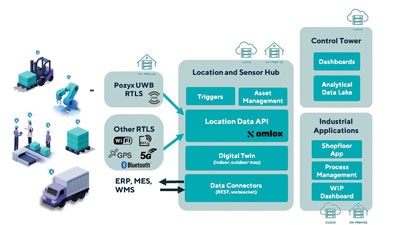
    The Pozyx Platform is an asset tracking and identification solution for seamless indoor and outdoor tracking, following packages or other assets from trucks to their destination. It is based on the omlox hub, an open standard for real-time location systems that combines GPS data with data from ultra-wideband, 5G, radio-frequency identification, Wi-Fi and Bluetooth. The Pozyx Platform offers a seamless indoor/outdoor transition with zoom-in from a worldwide map to a detailed indoor map, showing highly accurate locations up to 10 cm. It is designed for smart manufacturing, providing a supply-chain solution that supports Industry 4.0. It tracks and identifies any asset, providing real-time data to facilitate warehouse and inventory control, keep track of critical tools, and slash lost asset costs.

    Pozyx, pozyx.io

  • ADVA unveils high-performance optical cesium clock

    ADVA unveils high-performance optical cesium clock

    Service providers harnessing the solution can now offer GNSS/GPS- backup-as-a-service (GBaaS) with enhanced precision and availability

    OSA 3300-HP. (Photo: ADVA)
    OSA 3300-HP. (Photo: ADVA)

    ADVA has introduced its Oscilloquartz high-performance optical cesium atomic clock. The coreSync OSA 3300-HP is ADVA’s latest innovation in assured positioning, navigation and timing (PNT).

    Following ADVA’s launch of an optical pumping timing solution two years ago, the OSA 3350 ePRC+, the OSA 3300-HP takes the technology to new levels. It has a 10-year lifetime compared to the five years offered by currently available high-performance magnetic clocks.

    As a high-performance optical cesium clock, the OSA 3300-HP sets a new benchmark for precision and availability, ADVA claimed, providing the resilience required for PNT assurance in critical infrastructure and empowering service providers to deliver differentiated service-level-agreement timing offerings with integrated GNSS backup.

    The feature-rich device has embedded Ethernet- and IP-based management as well as a user-friendly touchscreen graphical user interface.

    “The launch of our coreSync OSA 3300-HP marks a key milestone in the design of atomic frequency and phase standards,” said Gil Biran, GM of Oscilloquartz, ADVA. “After many years of extensive work in our Swiss laboratories supported by the European Space Agency, we now have a mature, state-of-the-art technology that enables a major leap in the accuracy and stability of network timing while providing a substantially longer lifetime.”

    Atomic clocks offer synchronization backup for networks that rely on GNSS-based timing, combining high accuracy with outstanding availability. The OSA 3300-HP commercial high-performance optical cesium atomic clock features an all-digital design and leverages optical-pumping techniques using laser diodes. This enables it to measure 100 times the number of atoms, making it more efficient compared to existing primary reference clock (PRC) technologies.

  • Resilient PNT is critical, industry experts say

    Resilient PNT is critical, industry experts say

    As PNT becomes critical to more economic activities, any disruption in availability, reliability, resilience and integrity would weaken the critical infrastructure that sustains national security, business operations and public safety, according to experts speaking at the Geospatial World Forum.

    This growing dependency on PNT services — and the potentially high economic cost of vulnerabilities — underscores how vital GPS and GNSS systems are to the global economy and national security of countries worldwide, the experts said. Resilient PNT systems are necessary to combat GPS/GNSS outages.

    Robert Cardillo (Photo: GWF)
    Robert Cardillo (Photo: GWF)

    Building resilience into these systems will require multiple technologies ranging from network time-transfer services to terrestrial wireless infrastructure and low-Earth-orbit (LEO) satellites.

    The Geospatial World Forum opened in Amsterdam on May 10. The second plenary of the day focused on the value of PNT in the global economy. Geospatial World is a global think tank working towards raising awareness around the use of geospatial data and technologies among governments and policymakers, businesses, and the public at large.

    Robert Cardillo, president of The Cardillo Group and former director of the U.S. National Geospatial Intelligence Agency (NGA), headed the panel of experts.

    “Our existence on this planet has been shaped by our individual and collective awareness of place and our confidence to be able to move securely and efficiently from one place to another, all within that common framework of position, navigation and timing, or PNT,” he said.

    “The smartphone is a wonderful example of how far PNT has been integrated into our lives,” said Trimble founder Charlie Trimble. He laid down three basic phases involved in leading PNT to its place in the world economy.

    “The path from the dawn of space age to the smartphone was anything but obvious or straightforward,” Trimble said. “First, Sputnik led to the global navigation systems. Second, the Shuttle disaster led us to the realization that the satellite system was an information utility. And now, the integration of PNT into the mobile and immobile internet is changing our world.”

    From left: Charlie Trimble, Martin Sweeting, Rodrigo da Costa and Gillian Smith. (Photo: GWF)
    From left: Charlie Trimble, Martin Sweeting, Rodrigo da Costa and Gillian Smith. (Photo: GWF)

    “Our first contract was with ESA (European Space Agency) to look at the feasibility of using a navigation and timing satellite using small-satellite techniques, which in 1985 was considered a wacky idea,” recounted Martin Sweeting, executive chairman of Surrey Satellite Technology Ltd. “At ESA, we have embarked on a project called Hydro GNSS, which uses Surrey’s GNSS reflectometry to address several climate related issues, be it water detection or biomass, etc. This doesn’t stop here; we are looking at the lunar economy. PNT has indeed a very bright future, not just on Earth but also looking through this decade into the use of PNT on the lunar surface.”

    Rodrigo da Costa, executive director of the European GNSS Agency. (Photo: GSA)
    Rodrigo da Costa

    “New things are happening, particularly in the area of governmental satellite communications, space situational awareness and others, which are benefitting citizens every day,” said Rodrigo da Costa, executive director, EU Agency for the Space Programme (EUSPA). “Galileo, EGNOS (European Geostationary Navigation Overlay Service), Copernicus and GOVSATCOM programs are key areas of EU space activities. All these programs are massive investments and in the end, the result comes from their utilization in the different areas of our economy and daily life.”

    “Just in the United States alone, GPS is approaching USD 1 trillion in terms of economic impact and is doubling every 2-3 years. But it is a single point of failure. This highlights the need for resilient PNT,” said Gillian Smith, vice president of marketing, NextNav. “We believe that our needs have evolved beyond technology that was really created in the ’60s. We need increased accuracy and availability in the urban environments in particular.

    “I think many of you have experienced it if you’ve tried to use it in any major city,” Smith said. “That blue dot is going to bounce off of buildings and not be very accurate. We need indoor tracking and mapping. We need altitude data so that you know what floor you’re on when you’re thinking about accurate location. We also need to increase resilience and redundancy. That’s going to give us all increased security as well.”

    The Value of GPS

    GPS jamming and interference is a grave issue that has come under the spotlight particularly since the Russian invasion of Ukraine, according to Geospatial World.

    In 2019, a Washington, D.C., think tank documented more than 10,000 cases of GPS interference (jamming and spoofing) in the previous five years from Russia. By 2021, these had become increasingly sophisticated. In a peculiar case, the crew onboard NATO ships in Odessa saw their position being given as Crimea.

    In the past six months, even before the war on Ukraine began, there were reports of GPS jamming in and around that region. In March, the EU Aviation Safety Agency had issued warnings of GNSS spoofing and jamming for flights over Europe, in particular around countries neighboring Ukraine and Russia.

    Globally, the economic impact of GPS/GNSS disruption is difficult to state. The potential economic consequences of failing to sufficiently protect sources of PNT are enormous, with estimates ranging from millions to billions of dollars depending on the type, length, severity and geographic scope of the disruption.

    Furthermore, the impact of a GPS/GNSS outage extends beyond basic economics and could result in risk to life. Emergency services, distress beacons and telecommunications networks all rely on PNT services — any disruption could cause serious consequences.

    A 2019 report sponsored by the National Institute of Standards and Technology estimated that the loss of GPS would cost the U.S. economy USD 1 billion a day.

    A 2017 study in the United Kingdom estimated a five-day GNSS disruption would lead to an economic impact of GBP 5.2 billion (USD 7.2 billion), with road, maritime and emergency service impacts accounting for 88 percent of the cost.

  • Orolia and Hoptroff partner on traceable timing to protect networks

    Orolia and Hoptroff partner on traceable timing to protect networks

    Hoptroff’s Traceable Time as a Service to become an option for Orolia’s product portfolio; webinar scheduled for Dec. 15

    Orolia and timing solutions provider Hoptroff are partnering to deliver a service combining Orolia’s resilient positioning, navigation and timing (PNT) solutions with Hoptroff’s timing synchronization software.

    The collaboration will offer Hoptroff’s Traceable Time as a Service (TTaaS) as an add-on to Orolia’s suite of products, providing precise and verifiable time to customers in enterprise, financial, telecom, utilities, public safety, and other markets where traceable time is critical.


    Webinar scheduled

    Orolia and Hoptroff will host a joint webinar to discuss the partnership and new resiliency options for customers on Dec. 15 at 12 p.m. EST. Register here.


    Hoptroff’s TTaaS offers an additional level of security and precision to meet stringent regulatory and resilient infrastructure requirements by delivering accurate time over the network using a VPN connection over broadband or fiber networks.

    The bundled solution will simplify the challenge of getting accurate, traceable time in applications where GNSS access is not available or dependable. It can also serve as an accurate, reliable backup to GNSS to provide a high level of resiliency to timing systems being used in critical infrastructure.

    “As industries evolve and computer applications become more complex and widely distributed, it is essential that devices in a distributed process share the same accurate timescale to reconstruct digital events after the fact,” said Tim Richards, COO at Hoptroff. “Network-based traceable timing, such as TTaaS, provides resilient backup to a GNSS installation in the case of signal disruption, monitors the quality of performance of time servers, and keeps a record of this timing quality at a location of the customer’s choice. Our partnership with Orolia means businesses will now be able to back up and monitor physical time servers and virtual servers in the cloud, so that they can be sure they share the same accurate timescale, and they have the records to prove it.”

    “The partnership with Hoptroff aligns with Orolia’s resilient PNT strategy by providing a wireline solution to augment its space-based PNT solutions. This allows us to further simplify the challenge customers face when building a highly resilient timing solution,” said Jeremy Onyan, Orolia’s director of time sensitive networks. “By combining Orolia’s anti-jamming and anti-spoofing solutions, high-performance GNSS-based timing products, alternative signals like STL, a local high-quality oscillator, and now a wireline-based TTaaS we have one of the most robust portfolios of resilient PNT solutions in the market. Additionally, with the recent acquisition of Seven Solutions, we are well positioned to extend our capabilities into high-accuracy time distribution.”

    Seven Solutions is a global innovator in White Rabbit sub-nanosecond time transfer and synchronization technology. “With the capability to distribute time with little to no accuracy loss, Orolia’s customers using Hoptroff’s TTaaS or other time references such as GNSS can extend that time to other parts of their networks and create a high level of resiliency against potential outages,” Onyan added.

    Image: Panuwat Sikham/iStock/Getty Images Plus/Getty Images
    Image: Panuwat Sikham/iStock/Getty Images Plus/Getty Images
  • DOT report: L-band, UHF, LF and fiber PNT needed to protect US

    DOT report: L-band, UHF, LF and fiber PNT needed to protect US

    In a report issued on Jan. 14, the Department of Transportation (DOT) outlined the results of its GPS Backup Technology Demonstration project. As officials had previously projected, it called for a system-of-systems approach using multiple complementary technologies.

    The report called for an architecture that included signals from space in the L-band, terrestrial broadcasts in the ultra high frequency (UHF) and low frequency (LF) spectra, and a fiber backbone to synchronize and feed precise time to terrestrial transmitters.

    The demonstration project and report were mandated by Congress in legislation passed in late 2017 and funded in early 2018. Delays within the administration resulted in the project beginning in early 2019.

    Monty Johnson of OPNT demonstrates precise time transfer through 100 kilometers of spooled fiber-optic cable. (Photo: RNT Foundation)
    Monty Johnson of OPNT demonstrates precise time transfer through 100 kilometers of spooled fiber-optic cable. (Photo: RNT Foundation)

    Demonstrations

    Of 21 firms that offered to demonstrate their wares, 11 were selected. They were:

    • Echo Ridge LLC and Satelles Inc. Satellite-based PNT technologies using the S and L bands, respectively.
    • OPNT B.V. and Seven Solutions S.L. Fiber-optic time transfer using the White Rabbit Precision Time Protocol technology.
    • TRX Systems Inc. Dead reckoning technology with inertial measurement units and localized map matching supplemented with ultra-wideband beacons.
    • Hellen Systems LLC and UrsaNav. eLoran that uses LF transmissions.
    • Serco Inc. Medium frequency R-mode.
    • NextNav LLC. Metropolitan beacon system using UHF frequencies.
    • PhasorLab Inc. and Skyhook Wireless Inc. Both use Wi-Fi frequencies. Phasorlab uses a dedicated network of transmitters. Skyhook leverages existing Wi-Fi access points.

    Five of the demonstrations were conducted at Joint Base Cape Cod, with the remainder at NASA’s Langley Research Center in Virginia.

    Timing demonstrations were assessed for system:

    • coverage (service availability) within an “appropriate area” (wireless systems only)
    • accuracy and stability across an appropriate area
    • long-term accuracy and stability of time transfer to a fixed location
    • time transfer availability and accuracy to a fixed location under challenged GPS signal conditions.

    Positioning was evaluated for:

    • coverage within a defined region
    • 2D and 3D dynamic positioning service availability and accuracy
    • availability and accuracy of static positioning
    • long-term availability and accuracy of static positioning
    • long-term availability and accuracy of static positioning under challenged GPS signal conditions

    DHS work referenced

    The report also mentions an earlier set of demonstrations done by the Department of Homeland Security (DHS).

    In December 2018, DHS’s Science and Technology Directorate performed the work through the Homeland Security Systems Engineering and Development Institute. The project “demonstrated a combination of position and timing use cases for dynamic vs. static and indoor vs. outdoor applications, along with a time-transfer use case for critical infrastructure applications.” Systems from Locata Corp, NextNav, and Satelles were evaluated.

    The DoT report says that eLoran was not part of the DHS effort because of the lack of transmitters in the area. However, “DHS had previously studied eLoran performance under a Cooperative Research and Development Agreement (CRADA) with Harris Corporation and UrsaNav and had an understanding of its capabilities.”

    A report of DHS’ December 2018 work is not publicly available, though DOT says it was used to inform their efforts.

    The only publicly available information from DHS about the eLoran CRADA seems to be a 2016 press release. A presentation and other information  is available on the UrsaNav website.

    Findings

    The 437-page DOT report is filled to the brim with detailed information about the project, individual technologies, and demonstration results.

    The Executive Summary says that, in addition to the findings from the DHS December 2018 effort (which were not listed), the DOT demonstration had four key findings:

    1. All TRL-qualified vendors offered showed PNT “performance of value” and one showed value in all scenarios.
    2. Neither eLoran company succeeded in the Static Basement Timing scenario.
    3. R-mode ranging did not meet the minimum technical readiness level (TRL) of 6.
    4. Deployment effort and coverage (infrastructure per unit area) are significant cost factors.

    Addressing the needs of critical infrastructure owners and operators, the report concluded the needed “technologies are LF and UHF terrestrial and L-band satellite broadcasts for PNT functions with supporting fiber optic time services to transmitters/control segments.”

    Reactions and way forward

    Government officials and industry observers alike have welcomed the report, though it does leave some questions on the table.

    One is about other national PNT needs. The congressional tasking was to report on GPS backup technologies for critical infrastructure and national security. The Jan. 14 report focuses on critical infrastructure needs. Information on national security requirements, some of which is classified, was provided to Congress separately by DHS and the Department of Defense.

    “Economic and homeland security are sometimes considered by agencies and Congress as subsets of national security, sometimes not,” according to one analyst. “So, we don’t know if the needs of first responders, delivery services, civil government agencies, and other essential users were ever formally considered. The good news is that the combination of systems identified, if implemented and made available to all, would likely meet the needs of most.”

    Other open issues are about implementing the report’s recommendations.

    Some have been quick to point out that the demonstrations were to inform the government, not part of a procurement.

    “If this was for an acquisition, it would have been done differently,” said one government retiree.  “Rather than having vendors set up and operate the equipment, government evaluators would have been much more hands on. And they would have made every effort to do all the trials at the same location.”

    Going forward, cost will also an important factor, as mentioned in the report’s key findings. “Depending on who you want to serve and where, the costs of different technologies vary by orders of magnitude,” said one provider.

    Reaction from those involved with the demonstration project has been generally upbeat with praise for DOT’s effort and anticipation of more progress.

    Typical were comments from Ganesh Pattabiraman, CEO at NextNav, who appreciated the real-world scenarios DOT used in the project. Regarding next steps he said, “We look forward to working with Congress on implementing the report’s recommendations.”

  • LDACS-NAV could guide global aviation

    LDACS-NAV could guide global aviation

    GNSS is a critical single point of failure for navigation in the aviation industry. A new white paper published by Egis says it’s time for the industry to get rid of legacy navigation aids (NavAids) and catch up technologically with the rest of the communications industry.

    The following is summarized from “Is This the Time and Place to Finally Back up GNSS?” published by Egis.

    Current navigation backups are ground-based navigation aids such as distance measuring equipment (DME). These use post-World War II technologies, with very low spectrum efficiency. Some might find it surprising to learn that they are still using Morse code.

    While difficult to jam due to their strong signal, current navigation aids are not cyber secure. Due to their spatial distribution, they can be limited in their support to PBN (performance-based navigation) or any new concept of operations.


    The horizontal positioning error was measured under 10 m, so the LDACS-NAV would easily meet RNP 0.3 requirements.


    Legacy NavAids — NDB (non-directional beacon), ILS (instrument landing system), VOR (VHF omnidirectional range) and DME — all require a specific frequency band, various equipment, and airborne and ground antennas.

    As a result, the average commercial airliner can carry around seven specialized navigation antennas, and as many as 20 when accounting for all the other communication, navigation and surveillance (CNS)  functions. Having different radio systems is adding redundancy but makes the aircraft and the ground equipment very costly, as well as difficult to engineer and to maintain.

    Two major problems could affect the aircraft industry. First, software-defined radio, and powerful low-cost radio systems are available to the public and any ill-intended person could interfere, deactivate or worse, divert these vulnerable systems from their purposes. Second, spectrum is a finite and fixed asset (aviation uses 14% of the total available spectrum).

    Why hasn’t this problem been solved already?

    There are no market incentives for air navigation service providers (ANSPs) and airlines to make expensive investments in ground infrastructures and aircraft retrofits. With an average lifetime of 25 years per plane, commercial fleets take a long time to be renewed.

    Also, the aviation spectrum is protected, which has led to complacency and a lack of pressure to use the latest technologies to improve spectrum efficiency.

    Stakeholder Coordination. States, ANSPs, airlines, airports, aircraft manufacturers, communications providers and system providers all have their own interests and perspectives, which increases the difficulty in developing and maintaining a global CNS roadmap.

    Deployment. Once a roadmap is agreed on, the deployment challenge remains. For instance, the retrofit compliance date for ADS-B was pushed back from June 2020 to to June 2023 due to the pandemic. The capacity of aviation to evolve depends on when the operational and commercial benefits are clear, such as when GNSS was implemented for navigation.

    The Human Factor. Human factors have to be considered for any critical change in aviation. Pilots are trained on navigation aids and GPS, and used to communicating by VHF voice with air traffic control officers. This is the reason why the evolution of navigation and communication systems must be seamless with current systems or require an in-depth human-factor risk assessment.

    Potential Solutions

    To future-proof aviation and performance-based operating procedures, aircraft need both a broadband, IP-based datalink capable of VoIP and a secure, cost-effective alternative positioning, navigation and timing (A-PNT) system as a back-up to GNSS. Today, GNSS backup is the 70-year-old DME — using the signals from multiple DMEs, aircraft can locate themselves with reasonable accuracy.

    The main choices to replace the DME are either an enhancement of DME systems (Multi-DME RAIM, eDME, Mosaic DME) or an A-PNT solution (LDACS-NAV, WAM-TISb, SSR mode N, eLoran).

    If we look at the most mature solutions, the DME/eDME and the LDACS-NAV are the main options, and they represent a real dilemma.

    DME/DME. This solution represents the best GNSS backup currently available. One possibility is to improve the signal to improve accuracy. Other improvements would allow the detection of more than two ground stations, or even receiver autonomous integrity monitoring (RAIM) capability. Only small improvements need to be made to the signal and to the FMS (Flight Management System), making it the option requiring the least effort and expense.

    However, to reach a reliable Required Navigation Performance (RNP) standard of RNP 0.3, additional distance measurements are required, especially at low altitudes, and more DME facilities might be needed. Plus, this solution does not provide a secure, integrated communication and navigation solution and does not improve spectrum efficiency.

    Photo: AlexeyPetrov/iStock/Getty Images Plus/Getty Images
    Photo: AlexeyPetrov/iStock/Getty Images Plus/Getty Images

    LDACS-NAV. The L-band digital aeronautical communication system (LDACS) for continental ground communication is an IP-based data-link solution with a built-in navigation capability. It uses orthogonal frequency-division multiplexing, organized as a cellular network and sharing features with 3G and 4G. It works by detecting signals of opportunity within the communication exchange, and then multi-laterating the signals from at least four ground transmitters to calculate an airborne position. The frequency is ingeniously placed in the L-band between each DME frequency. It is built with interference mitigation algorithms and minimizes out-of-band radiation to protect DME.

    This solution is spectrum efficient, cybersecure, doesn’t require additional frequency assignment, and is scalable and adaptable to local needs. Given LDACS is almost certain to be implemented in communications to replace VDLM2, using this capability would be an easy choice for navigation.

    Features like air-to-air ranging, surveillance or enhancements to DFMC GBAS are possible. Also, additional navigation information can be transmitted, such as trajectory-based operations and 4D trajectories.

    Both Frequentis AG and Leonardo SpA have built fully functional and interoperable prototypes. In March 2019, the German Aerospace Centre (DLR) tested LDACS. The flight campaign showed its capabilities in practical scenarios with industrial demonstration equipment. The horizontal positioning error was measured under 10 m, so the LDACS-NAV would easily meet RNP 0.3 requirements.

    ICAO Recognition. An International Civil Aviation Organization (ICAO) standardization group has started work on LDACS for both communication and navigation. The LDACS-NAV will first be used to augment the DME system.

    More Study Needed

    To fully validate the LDACS-NAV concept, further studies and large-scale demonstrations must be conducted, and a cell-planning study needs to determine the number of necessary ground stations.

    Also, a detailed cost/benefit analysis must be undertaken to evaluate the cost of an EU-wide LDACS-NAV network. It would take into account the manufacturing and deployment costs of ground stations as well as equipment costs of multi-mode LDACS/VDL avionics, identifying whether it can support navigation functions.

    Also studied should be the benefits of having a GNSS back-up system, equipage costs of a dedicated avionic system and the direct operational benefits of providing a reliable, low latency and cost-efficient communication and navigation network for all aviation stakeholders, including secured proprietary information for airlines and aircraft manufacturers, and including full 4D trajectory-based operations and flight-centric air traffic management for ANSPs.

    If both the cell-planning study and the cost/benefit analysis suggest a positive economic advantage to implement the LDACS system compared to the current system or the other potential A-PNT solutions, then European institutions could select LDACS as the official long-term A-PNT solution in the CNS Roadmap & Strategy and enable the SESAR Operational Concept high-level goals. This would help accelerate the standardization and industrialization activities to resolve the current lack of redundancy in our CNS systems.

  • GMV’s navigation system chosen for Spain’s new F-110 frigates

    GMV’s navigation system chosen for Spain’s new F-110 frigates

    The F-110 frigate being developed for the Spanish Navy. (Artist's concept: Spanish Ministry of Defense)
    The F-110 frigate being developed for the Spanish Navy. (Artist’s concept: Spanish Ministry of Defense)

    The technology multinational GMV has signed a contract with Spanish corporation Navantia to develop and supply its SENDA navigation system for the future F-110 frigates.

    The F-110 frigates represent a technological leap forward in platform systems and its combat system, incorporating Industry 4.0 technologies to improve lifecycle-long system management.

    The various F-110 systems call for a continuous, precise, and trustworthy positioning, speed and attitude source. With this purpose in mind, SENDA incorporates multi-constellation (GPS and Galileo) satellite navigation technology compatible with both civil and military signals, plus differential GNSS corrections. It combines its GNSS navigation data with data received from external sensors, such as inertial navigation systems (INS) and pitometer logs. It includes state-of-the-art algorithms to provide robust navigation in contested GNSS scenarios.

    SENDA also includes a timing server that generates highly precise and stable timing signals, allowing the ship’s systems to synchronize with GPS time. SENDA guarantees timing-reference stability and negligible drift, even during prolonged periods of GPS downtime.

    SENDA is a redundant system with two complete functional subsystems working in active-active configuration, together with redundant GNSS signal distribution. Both systems, monitored in real time, exchange information to provide the overall system with the best possible solution.

    GMV has experience in aeronautics, land and naval sectors with platforms such as the Atlante tactical long-endurance UAV, the 8×8 Dragon ground vehicle and now the F-110 frigates.

    GMV worked with the Spanish Ministry of Defense MoD to develop a system prototype during the F-110 definition phase. The future F-110 frigates will replace the current Santa María class frigates starting in 2026.

  • Is it time for backup?

    alan_bio_pic
    Alan Cameron, Editor-in-Chief

    “It’s always been time.” That was the first answer out of the gate, given in Session 3 of the Munich Satellite Navigation Summit last month. Dominic Hayes, Spectrum Management and Policy for Galileo, EGNOS and Copernicus at the European Commission, was prompt off the mark. “GNSS is so good, so easy and so cheap, other means are falling out of use.” Therein lies the peril.

    That emotion was seconded by every other speaker on the panel. But of course. Virtually no one in the GNSS community at large, let alone those attending the Munich Summit, thinks otherwise.

    Thinking and action do not go hand-in-hand, however. GNSS back-up resembles the weather, in that everybody talks about it, yet … yet … nothing changes. As long ago as 2015, the U.S. Department of Transportation and the Deputy Secretary of Defense made noises about building an alternative system to GPS in case of disruption, and certainly there were hand gestures aplenty prior to that.

    backup-coverDo we have a back-up, presently?

    No. The U.S. government is in such a hurry to protect its borders that it gives scant thought to protecting what’s inside: critical infrastructure.

    Is it time?

    It’s always been time.

    Things are more like they are now than they ever have been, what with the cloud and all. We’re storing so much data in the cloud, with more and more of the world’s operations every day keyed to and driven by distributed database processing, in huge data servers around the world. This is according to John Fischer of Spectracom, who is in a position to know. Precise timing at the micro- and nanosecond level plays a huge role in connecting and synchronizing users. But again, he was preaching to the choir.

    Guy Buesnel from Spirent Federal reiterated the new threat sprung from Pokémon Go: a community of gamers and enthusiastic coders, generating homespun spoofing mechanisms for fun. They will soon realize, if they haven’t already, that there’s profit to be made there as well.

    “We have become too reliant on GNSS today,” stated Buesnel. Most interference warnings are low level, but 3 to 4 percent are serious enough to disrupt receiver operations. And that still means you have to take action in response. He stressed the importance of a balanced systems engineering approach, and invoked Brad Parkinson’s PTA mantra: protect, toughen and augment.

    Hayes called for a European Radio Navigation Plan, similar to the U.S. Federal Radio Navigation Plan (FRNP). Later, in response to a follow-up question, he acknowledged that “radio” need not be part of all encompassed systems; the proposed name is a legacy of modeling after the FRNP.

    So far, the FRNP itself is nothing but a model, a little architectural construct of what someday might be. But nothing’s been built, that particular someday is no closer, and meanwhile the threats loom larger.