Tag: GNSS data collection

  • Getac tablet selected for Leica’s new survey package

    Getac tablet selected for Leica’s new survey package

    Leica Geosystems has selected Getac’s fully rugged ZX70 Android tablet for the new Leica Zeno GG04 Plus Tablet package, designed for utilities, public services, transportation and construction.

    The new partnership will allow Leica Geosystems to bring comprehensive geospatial data-collection capabilities to its customers in all terrains and weather conditions, according to a Getac news release.

    Leica Geosystems selects Getac's ZX70 tablet To power its new Zeno GG04 Plus tablet solution. (PRNewsfoto/Getac)
    Leica Geosystems selects Getac’s ZX70 tablet To power its new Zeno GG04 Plus Tablet solution. (PRNewsfoto/Getac)

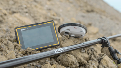
    The Zeno Mobile data collection app and Zeno GG04 plus smart antenna are designed to help customers capture highly accurate geospatial data quickly and effectively in the field.

    By combining these products with Getac’s ZX70 Android tablet, Leica Geosystems has created a solution that offers measurement accuracy, connectivity and durability in a single, comprehensive package, Getac said.

    Compact and powerful, the Getac ZX70 is comfortable to use with one hand, making it suitable for demanding field surveying work.

    Its Android operating system supports Leica’s Zeno Mobile software, allowing for high-accuracy GNSS positions to be utilized and rich attribute data to be collected easily in the field.

    Any authorized Android app can also be installed on the device, depending on the required workflow or back office systems used, bringing a high level of usability and familiarity out of the box, Getac said.

    Additional key features include the 7-inch IPS display, which is easy to read in all environments, including direct sunlight. The LumiBond 2.0 touchscreen allows for full operation of the tablet in the rain and with gloves on, essential for outdoor surveying work.

    The Getac ZX70’s integrated 4G modem can transmit large data files quickly and easily, even from remote locations.

    The fast, stable and reliable data connection allows users to effectively utilize Hexagon Geosystems’ HxGN SmartNet correction service, enabling accurate GNSS measurement to within one centimeter.

    The ZX70 offers durability, connectivity and usability, and has been designed to withstand shocks, drops, rain and vibration, the company added.

  • Eos and CartoPac partner to turn mobile devices into high-accuracy GNSS tools

    Eos and CartoPac partner to turn mobile devices into high-accuracy GNSS tools

    Eos Positioning Systems Inc. is partnering with enterprise mobile solutions provider CartoPac International to enable consumer smartphones and tablets to become professional-grade GNSS data collection and management devices for staking, inspections and more.

    Eos manufactures the Arrow receivers for any smartphone or tablet. CartoPac develops enterprise utility software, including a mobile solution for asset management and data collection.

    As utility and energy companies have begun to adapt smartphones as their primary data-collection devices, they have struggled to find integrated solutions that can tie the high-accuracy GNSS locations to their new and legacy assets. Their options were usually limited to onerous workflows of all-in-one handheld GPS devices or the hiring of specialized surveyors.

    Eos and CartoPac partnered to integrate the Arrow Series with CartoPac‘s mobile software. This allows CartoPac users to bring submeter and centimeter location into their asset-management solution on either iOS, Windows or Windows Mobile devices.

    One real-world example is the installation of an underground pipeline. A field user with CartoPac software and a high-accuracy Arrow receiver paired with an iPad was able to capture submeter asset data, scan the asset’s barcode, take photographs and populate the utility’s enterprise geodatabase in real time, the companies said.

    With the right mobile solution, field crews can also be dispatched in no time to the same asset location to respond to emergencies or perform routine work orders and inspections.

    “We saw our users struggling to get a good high-accuracy GPS solution within the iOS environment,” said Glenn Vlass, CartoPac co-founder and senior sales executive. “When you can say where an asset is spatially with such a degree of high confidence, that lowers your risk and improves your safety. Lower risk and improved safety are things every utility worker takes seriously.”

    Eos and CartoPac plan to expand their deployment of high-accuracy mobile asset management to more utilities facing similar needs.