The challenge of repairing GNSS stations in Bangladesh is recounted in a Nov. 6 article by Mike Steckler, a researcher with Columbia Climate School.
Steckler has been conducting research in the country for 25 years. He previously installed a continuously operating reference station (CORS) network in the southern region of the country.
Data from the network has enabled study of the tectonic motions of the Earth leading up to earthquakes. It also revealed the sinking of the land in the world’s largest delta to less than 1 mm/y.
“I still find that amazing compared to the days before GNSS became routine,” he writes. “I’ve been at sea where the crew had to use sextants to estimate our position to within 10 miles.”
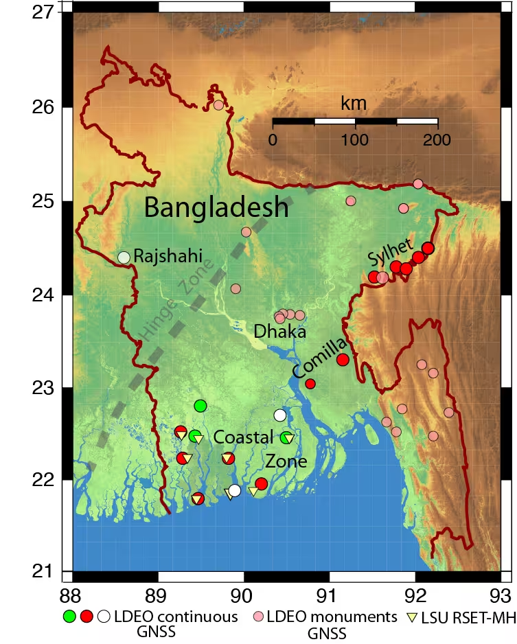
Of 16 stations running in the country, only three (green) were transmitting data back to the U.S. “I have returned here once again with others to get them working again and add three new stations (white),” Steckler writes.
Steckler was joined by a team from Dhaka University to visit the sites, make repairs and install new equipment.
Map of Bangladesh showing the locations of Steckler’s GNSS sites and regions he is visiting. The green circles are working systems, the red ones need repair, and the white ones are new. The pink circles are monuments with no active system. (Image: Mike Steckler)
Greenland is being twisted, compressed and stretched, according to researchers in the Department of Space Research and Space Technology of the Technical University of Denmark (DTU Space). As a result, the entire island has shifted northwest over the past 20 years by about 2 centimeters per year.
GNSS data shows plate tectonics and movements in the bedrock caused by the melting of large ice sheets, reducing pressure on the subsurface. The pressure is easing both because large amounts of ice have melted in Greenland in recent years, and because the bedrock is still affected by the enormous ice masses that have melted since the peak of the last Ice Age around 20,000 years ago.
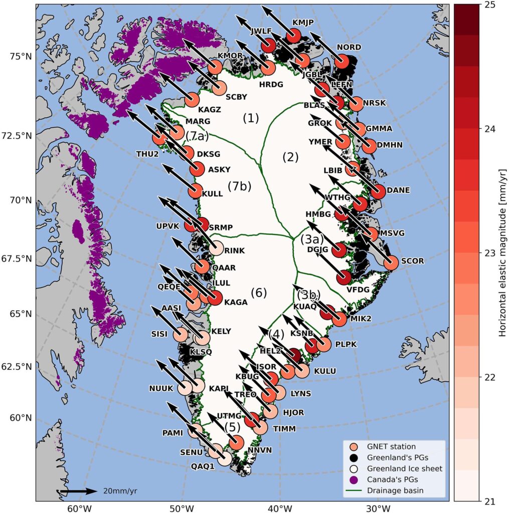
Horizontal land motion observed by the 58 GNET stations used in this study, processed in the IGS14 reference frame. Their location is shown by the colored circles together with their labels. The boundaries of Greenland’s drainage basins are shown in green with numbers (1) to (7b). The Greenland Ice Sheet (GrIS) is represented in white and peripheral glaciers in Greenland (GrPG) and Arctic Canada (CanPG) are highlighted in black and purple respectively. (Image: Study authors)
The new measurements are based on 58 GNSS stations placed around Greenland. They measure Greenland’s overall position, elevation changes in the bedrock, and how the island is shrinking and stretching. The movements are causing Greenland to both expand and contract horizontally. The effect is that Greenland’s area is currently being “stretched out” and becoming slightly larger in some regions, while others are being “pulled together.”
”Overall, this means Greenland is becoming slightly smaller, but that could change in the future with the accelerating melt we’re seeing now,” said DTU Space postdoc researcher Danjal Longfors Berg, lead author of the article in the Journal of Geophysical Research.
It is the first time the horizontal movements have been described in such detail.
”We have created a model that shows movements over a very long timescale from about 26,000 years ago to the present. At the same time, we have used very precise measurements from the past 20 years, which we use to analyze the current movements. This means we can now measure the movements very accurately,” Berg said.
Important for surveying and navigation
The new research provides useful information about what happens when climate change hits the Arctic with accelerating speed, as is the case in these years.
”It’s important to understand the movements of landmasses. They are of course interesting for geoscience. But they are also crucial for surveying and navigation, since even the fixed reference points in Greenland are slowly shifting,” Berg said.
The GNSS stations are owned by the Climate Data Authority under the Ministry of Climate, Energy and Utilities. They are used for research purposes and operated in collaboration with DTU Space. The research is conducted under the DTU Space research center Center for Ice-Sheet and Sea-Level Predictions (CISP).
The Hawaiian Volcano Observatory (HVO) of the U.S. Geological Survey has been working to rebuild its geodesic monitoring network after lava consumed several GNSS stations in 2018.
The work began following the 2018 Kīlauea lower East Rift Zone eruption and summit collapse, with funding from the Additional Supplemental Appropriations for Disaster Relief Act of 2019 (H.R. 2157).
Teams are rebuilding and improving HVO’s geodetic monitoring network to better detect, assess and respond to volcanic hazards related to Hawaiian volcanoes. The main geodetic datasets used by HVO scientists to measure surface deformation (ground movements) are GNSS, tilt and satellite radar (InSAR) imagery.
HVO’s geodetic network includes more than 70 GNSS stations and 15 tiltmeters on the Island of Hawai’i that continuously record and transmit data. These instruments require routine maintenance, must be upgraded periodically due to age, and must be replaced if destroyed by volcanic activity such as in 2018.
Network upgrades include replacing out-of-date instruments and improving HVO’s network of near real-time monitoring instruments at critical areas on Kīlauea’s summit and rift zones to support early detection of magma movement and associated hazards.
Lava takes out stations
In 2018, lava flows destroyed three GNSS stations in the lower East Rift Zone. Another three GNSS stations were destroyed in the caldera collapses at Kīlauea’s summit.
HVO staff rapidly deployed new GNSS stations at nearby locations to allow for continued monitoring during the eruption. These rapidly deployed sites included GNSS smart antennas mounted on surveys tripods — a setup typically only used for temporary deployments of several days to weeks.
Many of these rapidly deployed sites were decommissioned and removed after 2018. However, 13 of them are still being used for critical monitoring and remain on temporary tripods. These sites will be upgraded and hardened using engineered fixed monuments and masts. New sites will also be installed to replace sites destroyed in 2018.
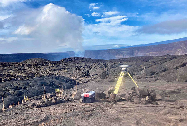
A temporary GNSS monitoring site in the Kīlauea caldera was part of the rapid response to the December 2020 Halema‘uma‘u eruption. The site will be upgraded into a continuously operating reference station with state-of-the-art instrumentation and a hardened antenna mast. (Photo: USGS/A.P Ellis)
Emergency monitoring ongoing
GNSS receivers acquired by supplemental funds already have supported emergency monitoring of active eruptions and other volcano-related activity. Data from these instruments help HVO detect volcanic activity and inform partners at Hawai’i Volcanoes National Park (HAVO), Hawai’i County Civil Defense (HCCD) and Hawai’i Emergency Management Agency (HI EMA).
For example, HVO rapidly deployed three new semi-continuous GNSS stations in response to the December 2020 Kīlauea eruption. These stations gave scientists a more complete view of magma returning to Kīlauea’s summit.
Similarly, HVO deployed rapid-response GNSS equipment at two pre-existing benchmarks during the Kīlauea south caldera intrusion event in August 2021, allowing scientists to track the migration of magma from the south caldera to farther south. New instruments give HVO a more detailed understanding of and ability to monitor Kīlauea’s volcanic processes.
HVO’s geodesy program plays a critical role in monitoring Hawaiian volcanoes. HVO’s updated geodetic network ensures that scientists can monitor changes in the shape of volcanoes, respond to eruptions, and understand magma storage and movement underground.
“Thanks to supplemental funding, HVO is in the best position ever to leverage our state-of-the-art geodetic network to gain insights into the active volcanoes in Hawai’i, assess their hazards, issue warnings, and advance scientific understanding to reduce the impacts of volcanic eruptions,” stated Volcano Watch, HVO’s weekly newsletter.