Mitch Narins, principal consultant & owner, Strategic Synergies LLC
Recently there have been conversations within the world’s position, navigation and timing communities regarding the use of the term “Gold Standard.” Many systems aspire to be a Gold Standard, but what does this mean and how should one rightfully claim this meritorious distinction? For me, to be called a Gold Standard, a system must meet a number of hard and soft performance requirements that instill users with trust and confidence. What are these performance metrics., and how should we measure them?
I propose that for a PNT system to be a Gold Standard, it must embody and embrace three basic operational aspects in its vision, mission and goals, which drive its design, development and operation:
Requirements. First, a PNT Gold Standard system must have clear, concise, published and independent operational requirements, established through recognized and appropriate standards — that is, the PNT “promises” of accuracy, availability, integrity, continuity and coverage provided by the system are available to all users, and any changes to these “performance requirements” are communicated and implemented in a formal and transparent process.
Monitoring. Next, a PNT Gold Standard must continuously monitor the system “health” to ensure that it is meeting all of its promised requirements (accuracy, availability, integrity, continuity and coverage). The measurements and monitoring information must be available to all users so they can, with confidence, independently verify performance in support of their missions and needs.
Transparency. Finally, and most importantly, a PNT Gold Standard must not only maintain transparency during normal operations, but at the most crucial times when the PNT system is not meeting its promised performance. When “things go wrong,” user communications and constant, continuous, and reliable information flows are essential to retaining trust (that is, the measure of the system operator’s integrity). “We don’t know what happened yet, but we will let you know as soon as we do” is acceptable; saying “no comment” is not. As soon as the cause of the problem is known, it must be promptly shared, in detail, along with the schedule for restoration of normal operations. All changes that will be implemented to preclude such an occurrence in the future and all lessons learned must also be communicated openly and honestly to users.
So, what is a PNT Gold Standard? It is a system that makes operational promises based on known and controlled standards and requirements and openly shares how performance against those promises is being monitored and assured. It is a system defined by mission, values, standards and operating principles that is committed to free and open communications when promised performance is being met and when it is not. It is a system that transparently documents, communicates, investigates and reports health and status to users without delay. It is a combination of known, measured and exceptional performance provided by a system operated with open, honest, inclusive, transparent and complete communications that evoke user trust. For me, that is what it means to be a PNT Gold Standard.
As we bid farewell to the last GPS-IIA satellite and read of delays to both the launch schedule for GPS III satellites and roll-out of the OCX program, we are mindful of the need to maintain GPS as the “Gold Standard” in GNSS.
Certainly, new signals, enhanced resilience and expanded capabilities are offered by the modernized GPS playbook. Delays relative to both the BeiDou and Galileo constellations could seriously impact the position of GPS on the medals podium — maybe not in the longer term, but certainly in the coming few years.
This may have a secondary impact on the receiver market, shifting focus away from GPS to more capable signals in the near term. Once GPS has caught up, receiver manufacturers may choose to retain the technology that they developed to capitalize on BeiDou and Galileo signals, rather than developing their legacy GPS capabilities.
GPS L2C is currently “pre-operational,” transmitted by slightly more than half the existing mixed-generation satellite fleet and waiting for OCX support. As of Feb. 20, a realistic estimate for operational capability of GPS L2C is now 2023.
GPS L5 is also pre-operational, transmitted by slightly less than half of the GPS satellites and waiting for OCX support. As of Feb. 20, a realistic estimate for GPS L5 is 2027.
The forecast for GPS L1C operational capability is the late 2020s. This is intended to be the signal that offers international interoperability with the current interoperability signals offered by existing BeiDou and Galileo satellites.
Delays to the implementation of GPS L1C may mean that GPS misses the interoperability boat entirely. During the delay, new interoperability capability with even more robust signals could be devised and lofted aboard Galileo, BeiDou and GLONASS satellites. By then, other countries could also develop their own constellations, possibly regional or even global systems.
Potentially, GPS could be left behind as other nations discuss non-GPS internationally interoperable signals on yet-to-be launched satellites. This may have a profound impact on SBAS, too. Differential corrections provided by the Japanese MSAS, Russian SDCM and European EGNOS SBAS systems might evolve to support “beyond L1C” interoperability signals. Aircraft landings at world airports could mandate the use of corrections to these new signals. This might mean that U.S. receiver manufacturers could be frozen out, or will have to incorporate these new interoperable signal standards.
GPS Block III satellites along with OCX offer improved signals, capabilities and resilience, but the satellites need to be flying, OCX needs to be operational and receivers need to be in the hands of the users. Sooner rather than later is a must for Gold-Standard GPS.
Paul Crampton is a senior systems engineer at Spirent Federal Systems with more than 30 years of GPS experience.
Elsewhere in this (January) issue you’ll find the hard facts — basic, but hard — concerning the inaugural launch of the long-awaited GPS III constellation. On pages 10 and 12, with some seasoned leavening between, on page 11.
This column instead waxes briefly on the phenomenon of time, and humankind’s struggle to dominate it, to subject the fourth dimension to its own will.
For GPS III has been, yes, long awaited, long debated, long victim to multiple delays of many colors and causes, scrutable and inscrutable, of technological challenges and institutional barriers, and of that base determinant, money. The Government Accounting Office has issued its fair and due share of reports pointing alarmed fingers at constellation gaps and fulfillment shortfalls and the trials of OCX, the ground control system without which GPS III satellites may some day, soon or not-soon, be capable of broadcasting powerful new signals from space, yet not able to do so because of lagging accomplishment on Earth.
It’s often said that GPS is a victim of its own success, that older satellites living beyond their forecast lifetimes have allowed the Air Force to economize by not replenishing when unnecessary. There’s wisdom in this, of course.
Were my friend Don Jewell still with us, he would be justifiably proud of the Air Force for launching this new golden era of the gold standard in positioning — yet he would have seethed for years over the continued pushes to the right.
This reminds me a good deal of the drama and occasional comedy in the rise of Galileo, observed from afar. Next month I’ll give a talk at the European Space Agency, provisionally titled “An Outside History of Galileo,” the bemused viewpoint of one who only heard and interpreted the news, but did not participate in its forming.
For such complex endeavors do not happen easily or speedily or exactly as planned by mere mortals. Nor should they. Despite much gnashing of teeth, no one — in the civil sphere at least — has suffered unduly from the longish delays in either satnav system’s modernization. Perhaps a few lives could have been saved in the military, or greater strategic advantage gained, with the new capabilities that III will offer warfighters, had same been available on schedule, say, four to six years ago. But even this is mere conjecture.
There is a rhythm and a flow to life, and we are part of it. You can hurry neither sundown nor sunrise. Things happen in their own due course.
When full GPS III capabilities arrive — I don’t believe 2023 — then it will still be in good time. In its own best time, actually, to be here.
Views from the top drive this issue of the magazine: personal essays from the directing officers and/or architects of each global satnav system.
The plots of the four articles are the same: what innovations were accomplished in 2017, and what new features to look for in 2018. But the themes differ. If you reflect at the end of each article, try to read between the lines, divine what message seems most important to the author — then distinctions surface.
I’m not suggesting that the directors of each satnav system are trying to accomplish different things. All share the goal of providing the highest quality product and service. I posit that the hands above these guiding hands, atop the top — that is, the national governments paying for each system and directing the directors — do indeed have different priorities. These priorities may produce differing results for industry, markets and users.
The column in November’s GNSS Design & Test e-newsletter elaborates on this hypothesis, as there’s not sufficient space here. Hyper-briefly: the most marked contrast appears between the United States on the one hand and Europe and China on the other. The former appears focused on maintaining the Gold Standard of signals, on beefing up security, and then pretty much letting the market take care of innovation once the space signal hits the Earth’s surface. The other two project clear messages of working closely with industry sectors to encourage and intensify use. For them, GNSS is an economic tool, not merely a political one.
As for my 2018, I will attend both events below, and hope to talk with as many readers as possible there.
Cognizant Autonomous Systems for Safety-Critical Applications Workshop
January 29, 2018 Reston, Virginia
Join a full day of expert presentations and discussions on the opportunities and challenges (technical, commercial, ethical and legal) associated with developing fully autonomous systems that are cognizant and trustworthy for safety-critical applications. Free; sponsored by the Institute of Navigation. Speakers from the National Science Foundation, Department of Transportation, Air Force Research Laboratory, Top Flight Technologies, University of California-Santa Barbara, Santa Clara University, The Ohio State University and more. View more details here.
Munich Satellite Navigation Summit: GNSS — The key to autonomy?
March 5–7, 2018 Munich, Germany
This three-day international conference focuses on the latest developments in satellite-based navigation, gathering high-ranking speakers from industry, science and governments for a broad overview and differing perspectives. Topics include status and real-world results of Galileo; modernization of GPS, GLONASS and BeiDou; developments of QZSS and NavIC; the need for GNSS authentication; civil use of Galileo Public Regulated Service; legal aspects of GNSS; and autonomy within a single GNSS — still possible? Get more details here.
Editor’s Note: Alan Cameron is editor-in-chief and publisher of GPS World magazine. He also writes the monthly GNSS Design & Test newsletter. The views expressed are his own.
“It’s tough to make predictions, especially about the future.” This insight comes from the 20th-century American sage Yogi Berra. Yet predictions — hedged guesses, if you will — form the basis of nearly all new business ventures and decisions in ongoing business activities.
For surveyors in the year 2015, one of the key predictions — or guesses — to make concerns the next GNSS to come predictably and reliably online, to augment GPS where GPS alone does not fully function: under canopy, in dense urban environments, and so on. More satellites visible at more varied angles in the sky can help surmount these obstructions.
Staking the future of one’s business, in the form of new equipment acquisition, in such an environment is a bit like betting on a long-distance horse race. First one steed surges to the head of the pack, then it falls back as another charges forward. We have seen this pattern repeatedly in the growth of GLONASS, Galileo and BeiDou.
Some may say that GLONASS, the Russian system, has already won the race (the first heat, at least) and currently fills the role of GPS partner in precision surveying. It does, to some extent, but its future viability is cloudy — and its past record is patchy, to say the least. It rose to full operational capability around the turn of the century, then fell very, very low in numbers as short-lived satellites expired and were not replaced at sufficient rate. Recently, GLONASS has mounted a resurgence, but that has been marred by repeated launch failures and a disturbing anomaly. It cannot be counted or confirmed a winner, yet.
I spoke yesterday with an expert and veteran professional land surveyor who expressed the opinion that the manner in which surveying is conducted will change more in the next five years than it has in the last 25. Keep in mind that the last 25 years saw enormous changes themselves, as GPS significantly transformed, upgraded and made vastly more efficient most surveying activities.
Betting on a horse race in such a rapidly changing environment becomes even more chancy.
Here’s a tip from a racetrack tout: don’t count Galileo out.
GLONASS we recounted briefly above. BeiDou recently achieved a regional operations status over Eastern Asia, but further developments there have been puzzlingly quiet for some time.
The European system has come on with agonizing slowness since the year 2000, suffering many delays and most recently what could have been a debilitating failed dual launch. But the combined strength of the European Union continues to push determinedly forward, and the program has an ambitious schedule with an eye firmly fixed on operability. And some recent research results tend — perhaps — to substantiate the claim, long pooh-poohed by those in the United States, at least, that Galileo will eventually prove “better” than GPS. Details further on.
What might a prudent yet pragmatic, forward-looking surveying firm do in this uncertain environment, where the only certainty is change, and likely to be rapid change at that? Here’s another racetrack tip: don’t make any big bets just yet, but study the field closely and continuously. In particular, watch Galileo’s performance.
A further item to be checked in Galileo’s favor: its system operators have long been in close talks with the U.S. government on many matters involving co-operation and interoperability. As recounted in a recent story concerning the Federal Communications Commission’s surprising role in this matter, the Europeans are filling out the proper forms for full accreditation within the United States. This could turn out to be important in business operations.
Back to studying the field closely: also study leading manufacturers’ offerings in this regard. They also are making bets on the future; quite possibly they have better information, and/or have done more extensive analysis of what information is available, paired with in-depth, highly technical research and development of signal characteristics and how signals from disparate GNSS can be most productively combined.
A quick scan of GPS World’s2015 GNSS Receiver Survey shows the following key manufacturers (among others) have GPS receivers now commercially available that are Galileo-ready: Altus Positioning Systems, Ashtech, Geneq, iFEN, JAVAD GNSS, Leica Geosystems, NovAtel, NVS Technologies, Septentrio, Sprecta Precision, Spectrum, Topcon, and Trimble.
Better than GPS???
Supporters of Galileo have long raised hackles west of the Atlantic with claims that Galileo would provide better accuracy than GPS. Not! cried the faithful, and especially not when the modernized and improved, strengthened, more accurate GPS III signals are coming along just as fast if not faster than Galileo. Recently the pace of GPS III has come into question; can the Gold Standard and clear leader for 25+ years really be falling back into the pack?
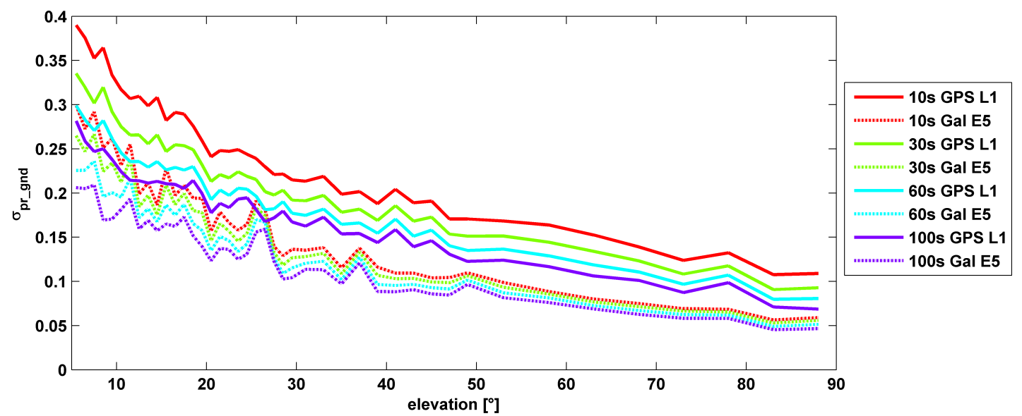
σ(pr_gnd) versus elevation for Galileo E1 (dotted lines) and GPS L1 (solid lines for different smoothing constants: red (10s), green (30s), cyan (60s), purple (100s).
Let’s disregard that question for the time being, and look at some recent research, to be reported in full in the cover story of GPS World magazine’s April issue, out soon. In it, the authors (two German and one American researcher) report:
“Analysis of new Galileo signals at an experimental ground-based augmentation system (GBAS) compares noise and multipath in their performance to GPS L1 and L5. Raw noise and multipath level of the Galileo signals is shown to be smaller than those of GPS. Even after smoothing, Galileo signals perform somewhat better than GPS and are less sensitive to the smoothing time constant.”
This is all pretty arcane and a bit removed from current field of operations, as far as surveyors are concerned. But it does signal something, and it provides food for thought.
The researchers obtained their results using four JAVAD Delta receivers, all connected to Leica AR 25 choke ring antennas.
Sometimes the patient has to get sick in order to get better. The eruption of a malady leads to identification of an underlying condition; appropriate treatment can then be devised to cure the body of its ills. Sound like House, M.D.?
As a variant on this plot line, the patient can know full well what is wrong deep down inside, but refuses to acknowledge or deal with it. As in, “I’ll stop smoking when I start coughing,” or “My drinking hasn’t gotten to the problem stage . . . yet.”
Let us examine the patient GNSS. The April signal outage, system-wide on the GLONASS constellation, lasted less than 12 hours. That was long enough to cause consternation for end users around the world, and for several voices to renew their calls for multi-constellation GNSS and alternative PNT. The interruption was also short enough that it has now vanished from most rear-view mirrors. Everything is back to normal and everyone can go about their business.
But the patient is still unhealthy, and vulnerable.
It is easy enough to fault the system operators, who after all are only human, and to say, “That can’t happen here. We have enough safeguards in place. And our guys and gals are just that good.” In other words, we take enough antibiotics and are generally, you know, well, healthy. As healthy as anyone else.
We have yet to see a full-scale jamming or spoofing attack on the order of cyber-security breaches in other targeted areas that have made off with millions or billions of dollars.
We have yet to experience a truly major-league Sun event, when global circumstances would be in dire need of PNT help just when GNSS was least helpful.
We have yet to encounter some other unknown, unexpected event or environment that will reveal in painful detail the vulnerabilities of GNSS.
Which are well known to us at this writing.
This month’s cover story on a new enhanced differential Loran technique represents one arm of geospatial-medical research. Notably, it evinces little concern for GLONASS, the area where the latest malady erupted. No, the Dutch harbor pilots are concerned about over-reliance on GPS, the Gold Standard. The Gold Standard! What could possibly be wrong with the Gold Standard? After all, it’s golden.
GPS III Misses Delivery Date. The U.S. Air Force is shopping for alternative companies to make future GPS III satellites after the first eight birds come through. Current contractor Lockheed Martin Space Systems missed a 2014 delivery date because, although it has three satellites in the production barn and a satellite test-bed vehicle that has successfully passed system tests, it has received no payload from subcontractor Exelis to put aboard same.
Delivery of the first GPS III satellite is now expected to slip from fiscal 2014 as far as fiscal 2016. Then there’s launch to consider, which brings to mind the launch budget and schedule, annually trimmed back by Congress. Then there’s OCX, needed to operate GPS III, also struggling to stand up.
Even once established, GPS III will share the same vulnerabilities of current GNSS.
Our esteemed editor-in-chief and publisher at GPS World, Alan Cameron, penned an editorial in January concerning claims made by the People’s Republic of China regarding the Gold Standard for PNT (position, navigation and timing). The Chinese recently claimed that its BeiDou system averaged a user range error (URE) of 2.5 meters using zero age of data (ZAOD), 95% of the time.
Alan correctly made the point that today BeiDou is strictly a regional system, and that while the published and arcane (30-year-old) standard for GPS is 6 meters under the same conditions, this is merely a standard, a never-to-exceed boundary, and not an actual URE measurement. GPS has always provided significantly better than 6 meters accuracy, with a reasonable age of data, while the GPS numbers for URE have significantly improved on a consistent basis since 1978 and today are the best in the world for any global PNT system.
Dr. Bradford Parkinson, the father of GPS, after reviewing the Chinese data pointed out that, “ If a GNNS has full view and an immediate update (such as Compass [BeiDou]) they can drive the AOD down, effectively becoming a WAAS system. This result would not represent a global capability. Plus, there are other errors for a single-frequency receiver in addition to the ionosphere (that is calibrated by WAAS and EGNOS), including troposphere modeling errors, and multipath that drive the ranging error up for a civil user depending on the situation.”
This data is very useful for GDOP (Geometric Dilution of Precision) statistics, which are quite surprising – and come about because of the 30+ GPS satellites in view and the resulting excellent geometry available.
The public data clearly shows that the GPS system is every bit as accurate, and indeed comparatively nominally much more accurate, than BeiDou, and GPS covers the entire globe, not just an area over China and portions of Australia.
It All Starts Here — GPS SIS URE
The GPS accuracy equation begins with the signal in space (SIS). Since 1978, the SIS figures for GPS satellites have continuously improved, as I said primarily due to more accurate orbit determination and more stable atomic reference systems, while the GPS URE numbers have continued to decline. Which is a good thing – smaller URE numbers are better.
Indeed, this clearly explains, in my opinion, why SVN49, which is a perfectly healthy GPS satellite, has never been set to healthy status. While the SVN49 GPS signals are all well within the published 6 meter URE – a never exceed threshold – they are significantly greater than 2 meters. Accuracy matters with GPS, so until corrections can be made, the satellite will remain in test status. Today, it serves as a very useful orbiting GPS test bed but does not enter into the SIS or URE equation.
GPS SIS URE is best explained as the pseudo-range inaccuracy due to ephemeris (orbit) and clock (atomic reference system) errors, which are common to all modern space PNT systems. The SIS root-mean-square (RMS) URE for GPS has been steadily declining over time (smaller numbers are better) and, consequently, so have the user range errors for users on the Earth. However, for my technical readers and space physics buffs, SIS errors are not determined by simple equations and therefore are sometimes difficult to describe accurately because they are neither purely stochastic nor deterministic. Indeed, Ph.D.-level subject matter experts such as Liang Heng, Grace Xingxin Gao, Todd Walter, Sherman Lo and Per Enge, from Stanford University, have clearly shown that SIS errors do not necessarily have a normal distribution Also, the traditional statistics such as sample mean and sample standard deviation may be affected by extreme excursions or outliers. However, these deviations do not significantly affect URE for most users, as they are effectively smoothed by long-term trend analyses and an active Kalman filter.
Better Clocks
Certainly, better atomic reference systems with frequency stabilities on the order of 1×10-E13 or better are partially responsible for these improvements, since one nanometer of clock stability typically equals one foot of position accuracy on the Earth’s surface. That number is important because I clearly remember the day in 1990 at the 1CACS (1st Command and Control Squadron) in Cheyenne Mountain (the 1 CACS is now located at Vandenberg AFB in California), when it was explained that the nominal ephemeris tracking error via optical systems for GPS satellites was on the order of two kilometers. The 1 CACS was responsible for providing collision-avoidance support during NASA shuttle missions and is still responsible for maintaining an extensive space satellite and space object catalog. Today, that error, using different tracking methods — including a global network of dual-frequency GPS tracking and monitoring sites — for GPS SVs approaches two centimeters or better. Consequently, better (more stable) clocks and more precise orbit determinations have greatly reduced the signal-in-space errors and significantly improved the position accuracy for all GPS users on a global scale. And for me that is the crux of the issue for GPS versus any other space-borne PNT system in existence today, or for any system in the near future.
A Global System
GPS is and has always been a global system, since its inception (1973) 41 years ago this year and since President Reagan decreed on September 16, 1983, just 15 days after Korean Air Flight 007 was tragically shot down by fighter aircraft from the Soviet Union (there were four other similar tragedies involving the Soviet Union on record) for being off course, that the Global Positioning System would be a gift from the United States to the world for precise navigation, so that this type of disaster need never happen again. Since that time GPS has been a truly global system for all users, friend or foe, without distinction. Of course longevity and dependability are merely two of the important factors that makes GPS the PNT Gold Standard.
GPS Stands Alone
I do not intend nor do I need to defend GPS as the global Gold Standard for PNT, the figures speak for themselves, however I do feel that the words Gold Standard, as I and many other subject matter experts, interpret them, may need a bit of an explanation.
One of my professional colleagues and a dear friend, for more years than I care to count, and I have long disagreed on this terminology. He feels the term Gold Standard is easily misinterpreted and should not be applied to GPS simply because it is not always well understood; instead he prefers the term system of first choice. However, that just does not have the same ring or historical significance as the Gold Standard.
What is a Gold Standard?
Leaving aside the monetary or financial implications for our PNT purposes, a Gold Standard is defined as the best one or the very best example of its kind — with synonyms such as: a system benchmark, a yardstick, a touchstone, the criterion, a paradigm and the epitome. Add to these descriptors the sense of longevity, endurance, dependability, and quality the GPS engenders among users — and you may be approaching the true sense of the phrase “Global PNT Gold Standard.” I can say unequivocally that the GPS is the only space-based PNT system in existence today that meets all these exacting and more fluid definitions simultaneously.
Historical Perspective
The Global Positioning System has had a continuous on-orbit presence since the second NRL Test and Development satellite was launched in 1977. GPS achieved IOC or Initial Operating Capability with 24 SVs (satellite vehicles) on December 8, 1993 (2SOPS celebrated the 20th anniversary of GPS IOC in December 2013). GPS FOC or Full Operational Capability was achieved on April 27, 1995, just 16 months later. Since that date, the GPS has never been less than fully operational, providing both the military Precise Positioning Service (PPS) and the civil Standard Positioning Service (SPS) to global users. As the staff writers at GPS Daily stated in a recent anniversary article:
Amazingly, though many Navstar satellites have been launched and been decommissioned over the past 20 years, four of the original Block IIA satellites which made up the IOC constellation (SVN-23,SVN-26, SVN-34, and SVN-39) are still operating and providing reliable PNT services as of this 20th Anniversary of IOC.
GPS has grown to become a vital worldwide utility serving billions of users around the globe. GPS multi-use PNT services are integral to the United States global security, economy, and transportation safety, and are a critical part of our national infrastructure. GPS contributes vital capabilities to our nation’s military operations, emergency response, agriculture, aviation, maritime, roads and highways, surveying and mapping, and telecommunications industries, as well as recreational activities.
It is not an overstatement to say GPS is fundamental to today’s technical infrastructure and culture. GPS provides the ‘winning edge’ to our warfighters and allies by delivering premier space-based PNT services to the nation and the world.
This indeed supports the definition, as I see it, of a Gold Standard for global PNT. A system that is long-lived, dependable, and just keeps improving every day. A ubiquitous utility that has changed the world we live in and the way we live our lives for the better, a system that now defines not only the critical national infrastructure of the United States but of many nations around the globe.
As for GLONASS, Galileo and BeiDou, we can have this discussion again in 20 years or so when they have been IOC and FOC for a credible period of time and have proven their accuracy, longevity and utility. For now, there is only one Gold Standard and that is the Global Positioning System.
What Is Don Reading?
This month, my reading preferences centered around mythical and real life figures in the CIA or Central Intelligence Agency. And frankly, sometimes it was hard to tell the difference.
screenshot: “Command Authority”
Command Authority, by Tom Clancy with Mark Greaney Putnam and Sons, ISBN: 978-0-399-16047-9
I devoured this 740-page tome in one weekend and was looking for more when I finally finished. This is one of those books you don’t want to end. It describes the life of the young Jack Ryan as a CIA operative during the Cold War, and of his son, Jack Jr., today. The authors manage the timeline to and fro adroitly so that it is never an issue. As usual, the action spans the globe and as far as I can determine the historical facts are accurate and the scenarios are riveting but believable.
Tom Clancy passed way just about two months before this final book was published. He managed to write 28 books in 30 years, a prodigious feat considering most of them were on the order of 700 pages or more (Threat Vector runs 840 pages). But to my mind, they were all too short, and Tom managed to exit, as any writer would desire, leaving his avid readers yearning for more.
Until next time, happy navigating, and think about what a difference GPS, the PNT Gold Standard, has made in your life. You might be surprised. And then grab a good Tom Clancy book. You have 28 excellent volumes from which to choose.
BeiDou Releases Public Service Performance Document
In late December, director Ran Chengqi of China’s Satellite Navigation System Management Office announced the BeiDou Navigation Satellite System (BDS) Public Service Performance Standard. The document details the public service performance parameters of the BeiDou system, including service area, accuracy, integrity, continuity, and availability. It is a basic commitment to customers from BDS providers, but also an important basis for customers to choose, use, and evaluate the system performance.
Also released is Version 2 of the BDS Interface Control Document (ICD) for the Open Service Signal. Among other changes, it includes a description of the B2I signal on 1207.140 MHz.
The publishing of the Public Service Performance Standard, a common practice among GNSS operators, is also a prerequisite for BeiDou system involvement in international civil aviation, international maritime, 3rd Generation Mobile [phone] System, and other international standard-setting organization activities.
The document has Chinese and English versions. Because document download from the BDS government website can be difficult, Richard Langley has made them available at the University of New Brunswick website:
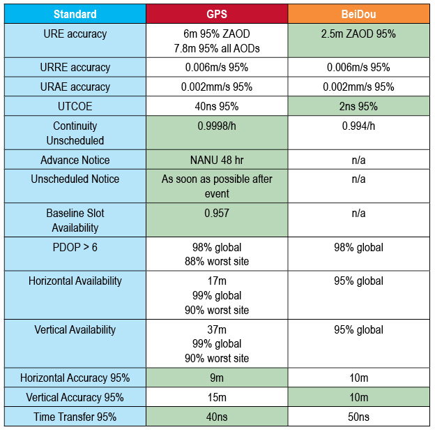
Analysis. John Lavrakas of Advanced Research Corporation posted the following comment to the online version of this news story:
“I took a quick look at comparing the BeiDou Open Service Performance Standard with the GPS Standard Positioning Service Performance Standard and obtained mixed results.
“In some cases, the commitments from BeiDou were stronger (URE accuracy, the table to show green for the GNSS service committing to a more stringent standard over the other vertical position), and in other cases the commitments from GPS were stronger (continuity of service, advance notice of outages).
Table 1. Coded to show green for the GNSS service committing to a more stringent standard over the other. Courtesy of Advanced Research Corporation.
Galileo to Sail, Penalty-Free
Schedule Overruns Not a Problem, Avers Space Agency Director-General
Athough the European Commission (EC) sternly put in place financial penalties for late delivery and arrival on orbit of Galileo satellites, the European Space Agency (ESA) that manages the process will not suffer the consequences of a one-year delay in their launch. The EC did not sign an industrial contract with the ESA for the Galileo work, according to an announcement by ESA Director-General Jean-Jacques Dordain made the announcement in mid-January 17.
Dordain said under the agreement, the EC pays for ESA’s staff costs, while ESA acts as technical manager for the program. But the industrial contract itself to build the satellites — and specifying the penalities — was not encompassed by this agreement.
Galileo’s schedule is now firmly back on track, according to ESA,since the first OHB satellite passed thermal-vacuum testing in November, and the second satellite is in the test chamber. Signals are apparently “go” for their launch in June aboard Soyuz rocket from Guiana Space Center in South America. A second pair should launch in October, and a third in December.
Meeting an Aggressive Date. The EC committed some time ago to start initial Galileo services in 2014. Delivery on this promise has become increasingly unclear after recent testing delays. Getting new Soyuz launch dates withing this year is not a sure-fire thing, either.
The Galileo Supervisory Authority earlier announced that it had validated the four initial operating-capability (IOV) Galileo spacecraft in orbit as perform twice as well as expected in terms of signal accuracy. However, the satellites provide very limited use, about one hour per day when all are visible to the same user.
Once six satellites become visible inthe sky, sometime after the planned June launch, testing qualification of early services can begin. With eight, actual service qualification is possible but not certain. Finally, with 10 satellites — December? — early services may be able to start.
Earlier last year, EC Vice President Antonio Tajani had warned that financial penalties to those building Galileo would cover the cost overruns due to the delay in launching the system. His finger appeared to point at ESA as much as OHB AG of Germany and Surrey Satellite Technology Ltd. of Britain, who lead the industrial consortium building the satellites.
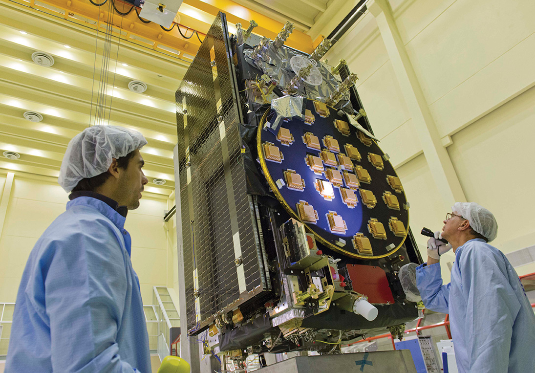
The main antenna of the second Galileo Full Operational Capability (FOC) satellite being inspected with a flashlight in advance of mass property testing at the European Space Agency’s ESTEC Test Centre in the Netherlands. Thermal-vacuum testing on the second model began in early 2014. The two FOC satellites will be launched on a Soyuz rocket from Europe’s French Guiana Spaceport in mid-2014. Whether four more can rise and begin providing initial Galileo services by the end of the year is the question of the hour.
U.S.Transport DepSec Takes Potshot at CNAV
The departing Deputy Secretary of Transportation, John Porcari, wrote a letter in the closing days of 2013 opposing the U.S. Air Force’s announced plans to begin broadcasting Civil Navigation (CNAV) message-populated L2C and L5 signals as early as April 2014. Military personnel are incensed over what they see as Porcari’s impugning, when not ignoring, the Air Force 35-year track record of broadcasting the gold standard of global navigation satellite signals — something in which Transportation has zero experience.
Porcari alludes in his December 27 letter to “non-standard engineering tools” and “non-standard operations” that he believes would come into play for early CNAV broadcast. “These have the potential to inject human error, which may result in unacceptable GPS constellation operation.”
What Porcari means by “non-standard” he does not specify, although he confesses to unease as “the ability to monitor these signals, [without which] the system will not know if the L2C and LS signals are within specification. Given these risks, DOT is concerned that the CNAV messages could provide hazardously misleading information, impacting GPS safety-of-life, protection of property, and economic security applications.” The full text of the Porcari letter is available here.
OCX Delay the Cause? Because the current GPS ground control system cannot generate CNAV, and the next-generation OCX —which can — will not be ready by April, anothercomputer will apparently develop the civil signal navigation data. However, neither the data or message is intended for actual use, nor will the FAA or any transport agency employ it. The advance project is designed to aid reciever manufaturers and developers in adpting to the new signal.
In addition to questioning Air Force 2 SOPS ability to broadcast an accurate, compliant signal containing CNAV, the letter appears to ignore — or be ignorant of — the 17 official U.S. government/military monitoring sites for GPS distributed around the world, not to mention thousands of other monitoring sites run by government agencies such as the Jet Propulsion Laboratory, the National Aeronautics and Space Administration, and the National Geospatial-Intelligence Agency, and by many universities such as Stanford, Ohio State, Cal Tech, and many other international institutions around the world. Many of these sites collaborate under the rubric of the International GNSS Service.
Finally, John Deere and Trimble Navigation both operate automated GPS signal monitoring systems that that report any anomaly in the navigation message for all GPS signals with an average two-second notification time.
“This letter is so much BS,” fumed one source who wished to remain anonymous, “coming from an agency that is in arrears in its GPS payments to the tune of more than $70 million and has no clue how to represent the global GPS user. GPS is a ubiquitous system, not just a tool for the DOT and the Federal Aviation Administration. GPS needs to implement these signals for all users and as a modernization program that was promised to be in place years ago.”
Porcari left for the private sector.
OCX Change Order to Ensure Proper M-Code Function
Raytheon Intelligence and Information Systems has been awarded a change order for work that costs up to $8.5 million on its existing contract to ensure that the new military signal, M-code, works with the GPS Operational Control System, according to an announcement from the Pentagon as reported by Space News.
Raytheon is building the ground station (OCX) for a new generation of satellites that will bring more safety and precision to GPS. The contract modification is to assure implementation of M-code capabilities across OCX Block 1 and 2. M-code is the new highly secure, anti-jam signal designed for the GPS III constellation. The current GPS ground control system lacks M-code capability.
The OCX is designed to work with the advanced GPS III positioning, navigation and timing satellites, slated to start launching in 2015, and also will be backwardly compatible with existing GPS satellites.
Raytheon won the $886.4 million prime contract to develop the OCX in February 2010. Work will be performed at Raytheon’s facility in Aurora, Colorado, and is expected to be completed by August 31, 2016.
The Air Force Space and Missile Systems Contracting Directorate, Los Angeles Air Force Base, California, is the contracting agency.
Details. Raytheon Intelligence and Information Systems, Aurora, Colorado, was awarded the unpriced change order (P00112) with a not-to-exceed of $8,595,748 on an existing contract (FA8807-10-C-0001) for M-Code Implementation on the Operational Control System. The contract modification is to assure implementation of M-Code Capabilities across OCX Block 1 and 2. Work will be performed at Aurora and is expected to be completed by August 31, 2016. Fiscal 2014 research and development funds will be obligated at definitization.
GAGAN Certified for Aviation over India
The Director General of Civil Aviation of India has certified the GPS-Aided Geo Augmented Navigation (GAGAN) system to Required Navigation Performance 0.1 Nautical Mile (RNP0.1) service level.
Aircraft equipped with satellite-based augmentation system (SBAS) receivers can now use GAGAN signals in Indian airspace for en route navigation and non-precision approaches without vertical guidance.
Mission control centers and uplink stations now operate on Indian soil. Messages carrying corrections to GPS signals are sent to satellites in geostationary orbit carrying the GAGAN payload.
The availability of the GAGAN signal over Indian airspace bridges the gap between European Union’s European Geostationary Navigation Overlay Service (EGNOS) and Japan’s Multi-functional Satellite Augmentation System (MSAS) coverage areas.
The SBAS consists of 15 Indian reference stations, three uplink stations, three mission control centers, and three GAGAN payloads broadcasting in C and L bands and with all the associated software and communication links.
GAGAN will provide augmentation service for GPS over India, the Bay of Bengal, South East Asia and the Middle East expanding up to Africa.
Car, Nav Makers Emulate NSA: Track, Store Consumer Data
U.S. Big Three automakers and some Japanese car companies track and store data from customers’ on-board navigation systems, according to a report from the U.S. Government Accountability Office. The document describes, in general fashion, practices at General Motors, Ford, Chrysler, Toyota, Honda, and Nissan, and further delves into data storage by GPS manufacturers Garmin and TomTom and nav app designers Google Maps and Telenav.
The GAO said the automakers collect data at times to assist customers with traffic updates, emergency roadside assistance, and to track stolen vehicles.None of the companies currently sell the data, according to the report, but most drivers do not know what information is being tracked and cannot opt out of the data collection programs.
The companies can “track where consumers are, which can in turn be used to steal their identity, stalk them or monitor them without their knowledge. In addition, location data can be used to infer other sensitive information about individuals such as their religious affiliation or political activities.”
The report claims the companies’ privacy policies are sometimes unclear, making it difficult for consumers to understand the potential risks of using their GPS navigation devices.
No federal law regulates GPS privacy; it is not illegal for private companies to collect, use, or sell personal information. Several proposals have been floated in Congress to protect the privacy of GPS data, but none enacted.
China’s BeiDou system claimed a user range error (URE) of 2.5 meters zero age of data (ZAOD) 95% recently. The parallel GPS specifications commit to 6 meters 95% ZAOD and 7.8 meters 95% all AODs. Does this mean that BeiDou is more accurate than GPS? Not so fast.
In late December, director Ran Chengqi of China’s Satellite Navigation System Management Office announced the BeiDou Navigation Satellite System (BDS) Public (or Open) Service Performance Standard. The document details the public service performance parameters of the BeiDou system, including service area, accuracy, integrity, continuity, and availability. It is a basic commitment to customers from BDS providers, but also an important basis for customers to choose, use, and evaluate the system performance.
A few important qualifications of BeiDou’s performance standard first:
According to the foreword of the document, “This document specifies the BDS open service performance standard at the current stage.” This is as it should be.
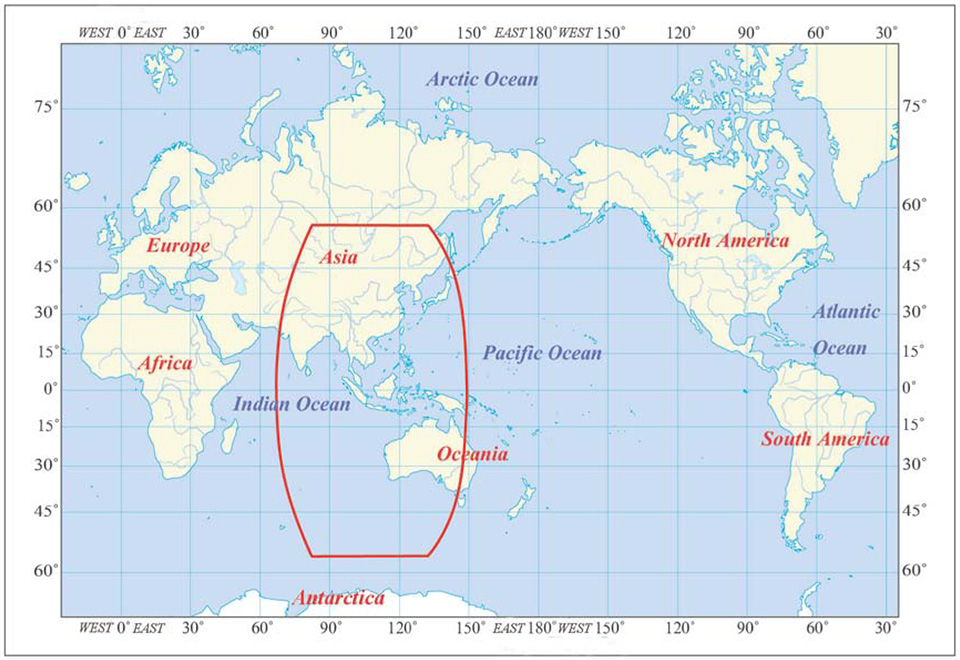
A paragraph on service volume, however, highlights the fact that BeiDou is as yet a regional service.
“4.4 BDS OS Service Volume
The BDS OS service volume is defined as the OS SIS coverage of the BDS satellites where both the BDS OS horizontal and vertical position accuracy are better than 10 meters (probability of 95%). At the current stage, the BDS regional service capability has been achieved, which can provide continuous OS to the area as shown in Figure 2 & Figure 3, including the most part of the region from 55°S to 55°N, 70°E to150°E.”
The BDS Service Area.
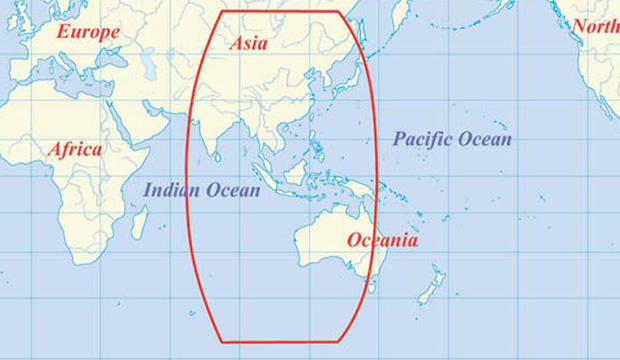
This means that BeiDou commits to 2.5 meter accuracy in China, as well as neighboring countries — and importantly, trading partners — in Southeast Asia plus Australia.
Does this mean that once BeiDou attains global status, it will provide 2.5 meter accuracy everywhere, on its basic single frequency, open service? Hard to tell. Much of its strength, its core strength, one might say, comes from 5 geostationary Earth orbit (GEO) satellites and 5 Inclined Geosynchronous Satellite Orbit (IGSO) satellites. The GEOs hover over the Equator more or less permanently, south of but in the general longitude of China’s sovereign national territory. The IGSOs move back and forth from the northern to the southern hemispheres in the same area.
When BeiDou achieves its planned global reach, an event scheduled for 2020, the constellation will consist of 35 satellites: 5 GEOs, stationed at longitudes so their footprints cover China, 27 medium Earth orbit (MEO) satellites encircling the globe in continuous paths as do those of GPS, and 3 IGSOs over the East and Southeast Asian regions.
Will globally available accuracy at that point match what is achievable in China? It takes a better geometric mind than mine to fathom this.
Even disregarding the geographic limit of the 2.5-meter claim, and ignoring for the moment the mathematical conundrum outlined above, there are reasons to scrutinize the BeiDou Performance Standard more closely, as John Lavrakas of Advanced Research Corporation has done. His notes, and an illuminating table, follow below after a bit more introduction and background on the general topic.
The publishing of the Public Service Performance Standard, a common practice among GNSS operators, is also a prerequisite for BeiDou system involvement in international civil aviation, international maritime, 3rd Generation Mobile [phone] System, and other international standard-setting organization activities.
The document has Chinese and English versions. Because document download from the BDS government website can be difficult, Richard Langley has made them available at the University of New Brunswick website:
John Lavrakas of Advanced Research Corporation posted the following comment to the an earlier online article announcing the Performance Standard document.
“I took a quick look at comparing the BeiDou Open Service Performance Standard with the GPS Standard Positioning Service Performance Standard and obtained mixed results.”
Table 1. Coded to show green for the GNSS service committing to a more stringent standard over the other. Courtesy of Advanced Research Corporation.
“In some cases, the commitments from BeiDou were stronger (URE accuracy, vertical position), and in other cases the commitments from GPS were stronger (continuity of service, advance notice of outages).
“The good news is that GNSS systems are documenting the service levels that users can expect. What we will need next is monitoring to verify these service levels are being met.
A final note. As the GPS stewards from the U.S. Air Force carefully and proudly remind us at each GNSS conference where they deliver a briefing, actual GPS performance has almost always bettered its specs over the last decade or two — often by a considerable margin.
And with that, I think we may all return to our various pursuits, secure in the knowledge that while the gold standard may — repeat, may — at times pass in limited special circumstances or under particular conditions, from system to system, overall GNSS Things Are Getting Better All the Time.