In early August, the U.S. Government Accountability Office (GAO) released its third report in 15 months about GPS and other positioning, navigation and timing (PNT) issues within the Department of Defense (DOD). Each report raised raised concerns about the way in which PNT programs were being managed and led within the department.
Observations included that DOD continues to rely heavily on GPS despite known vulnerabilities. Also, that alternate PNT efforts are not well coordinated and receive little support.
“Opportunities” for DOD to improve its alternate PNT efforts, according to the report, include:
Improving coordination across the services
Clarifying authorities and responsibilities for prioritizing needs
Focusing on resiliency versus GPS as the cornerstone of department PNT efforts
Clarifying PNT requirements rather than just defaulting to GPS as “the need”
The report pointed out that M-code has been in development for 20+ years, and that GPS satellites have been capable of transmitting M-code signals since 2005. Also, while there are still program risks, the Next Generation Ground Control Segment, known as OCX, is forecast to be ready to support M-code use by 2023.
OCX has experienced severe cost overruns and is more than five years behind its original schedule. GAO issued a report on OCX delays in May 2019.
M-code won’t really be a capability in DOD, though, until user equipment is widely fielded. That will take several more years, according to GAO.
One of the remaining challenges to M-code implementation, GAO said, was that the department did not collect and validate all the data it needed for leadership planning and prioritization.
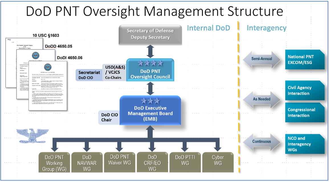
A summary on the first page of the report contains what could be seen as harsh criticism of how PNT efforts are led within DOD:
“DOD’s overall PNT portfolio is managed by the PNT Oversight Council, a statutorily established senior-level body. However, the Council has largely prioritized modernizing the existing GPS system over alternative PNT efforts during recent meetings and has no strategic objectives or metrics to measure progress on the alternative efforts.”
Image: DOD
Too Much Leadership?
Some believe the real problem with DOD PNT is not a lack of leadership, but rather too much.
“If everyone is in charge, no one is,” commented one retired senior military officer familiar with the issue.
“Congress has been concerned about DOD’s lack of attention to GPS and PNT alternatives for years,” the individual said. “In 2015 Congress mandated creation of the Oversight Council to help ensure PNT got the right amount of leadership attention.” This may have not had the desired effect, though.
“The council is comprised of three undersecretaries, the vice chairman [of the Joint Chiefs of Staff], four combatant commanders, the NSA [National Security Agency] director, DOD’s CIO [chief information officer], and host of other very senior folks. All of whom have way too many other duties. It’s no wonder the department has a hard time getting things done!”
The department’s CIO is the Defense Secretary’s Principal Staff Assistant for PNT. As such, the CIO is tasked with coordinating department-wide efforts. The task is made particularly difficult by the many and diverse players across the department, all of whom have their own authorities, interests and projects.
Proposed systems and capabilities are examined and developed by a variety of DOD organizations. These include laboratories belonging to the five services and the Defense Advanced Research Projects Agency (DARPA).
Programs of Record, which usually lead to acquisition of large systems, are led and managed within the individual services.
A Better Way?
Aside from recommending improved coordination of PNT efforts across the department, GAO has never addressed the way DOD manages its PNT enterprise.
“That is not something we normally get into unless specifically tasked,” said one of the reports’ authors. “We assume departments know best how to lead and manage their efforts.”
Others are not so reticent. They believe the current management structure is incapable of managing the development, acquisition and fielding of the DOD PNT Enterprise with any urgency or efficiency.
“GAO’s focus on the Oversight Council is misplaced,” one retired official asserted. “The missing piece is not oversight, it’s day-to-day DOD-wide management.”
“They need a multi-service program of record for resilient PNT,” the official said. “This would be separate from the GPS program, which would keep its own projects going and feed into the resilient effort. The new resilient PNT program should be managed by a Joint Program Office, which could consolidate integration and acquisition of resilient PNT applications. The office would be the steward for the critical technologies that underpin the modular, open-system integration strategy, including the digital reference architecture, input and output standards, software fusion engines, and needed modeling and simulation tools to ensure NAVWAR compliance.”
Such a construct could provide needed focus and coordination to DOD efforts, address many long-standing congressional concerns, and, by coordinating efforts within DOD and with industry, accelerate progress.
Dana A. Goward is President of the Resilient Navigation and Timing Foundation. He serves on the President’s National Space-based Positioning, Navigation, and Timing Advisory Board.
A May report by the Government Accountability Office (GAO) explores Department of Defense (DOD) strategy for positioning, navigation and timing (PNT) technology to complement GPS. The 51-page report takes a comprehensive view of alternative PNT policy and leadership across the department.
While GPS will remain the core of DOD’s PNT solution, it will use other PNT technology to complement GPS or as an alternative for when GPS is degraded or unavailable. DOD is exploring both improved sensors to provide relative PNT information, and external sources to provide absolute positioning and navigation.
DOD also is working to create common standards and interfaces to help integrate and field new PNT technologies faster and at lower cost. DOD also is developing its PNT modeling and simulation capabilities to evaluate the performance of new PNT technologies.
Challenges for DOD
Officials from across DOD and experts told GAO that alternative PNT solutions are not prioritized within DOD. For example, there is no central program office responsible for developing the variety of alternative PNT technologies across DOD.
DOD’s continued reliance on GPS, despite known GPS vulnerabilities to disruption, presents a challenge for obtaining sufficient support to develop viable alternatives. Defense officials and experts also said challenges in establishing clear PNT performance requirements hinder technology development.
In response, GAO developed six policy options that may help address challenges with developing and integrating alternative PNT technologies. The policy options identify possible actions by policymakers, who may include Congress, federal agencies and industry groups.
Increase collaboration. Consider mechanisms to coordinate across DOD to clarify responsibilities and authorities in prioritizing the need for alternative PNT technologies.
Focus on resiliency. Consider selecting the most resilient technologies as the cornerstone of the PNT suite for military missions, rather than defaulting to GPS.
Clarify requirements. Consider opportunities to clarify what level of PNT performance actually is needed for missions, rather than defaulting to requirements that match GPS performance.
Coordinate with industry. Consider ensuring DOD and industry coordinate so that industry is prepared to meet DOD’s needs, and DOD can leverage industry advances.
Institutionalize open architecture. Consider making the open architecture initiative more permanent, including providing funding.
Analyze vulnerabilities. Consider having DOD conduct ongoing analysis of vulnerabilities of different PNT systems.
The GAO reviewed technical studies, agency documents, and other key reports; interviewed government officials and researchers about alternative PNT technologies; and convened a three-day meeting of experts from government, non-governmental organizations, academia and industry.
It said policymakers “could consider selecting the most resilient technologies as the cornerstone of the PNT suite for military missions, rather than defaulting to GPS.”
The 51-page report takes a comprehensive view of alternative PNT policy and leadership across the department. Its findings are an interesting and informative look at issues and efforts.
Increasing demands
The report comes at a time when U.S. forces have been seeing increasing interference with their own and allied GPS-enabled systems. The Organization for Security and Cooperation in Europe has regularly reported that its surveillance drones in the Ukraine have been jammed. Chinese press recently bragged that jamming caused U.S. Navy ships in the South China Sea to switch from using GPS to the Chinese BeiDou system. Additionally, U.S. military commanders have regularly described the Middle East as the most contested electronic warfare area on the planet, in large part because of regular interference with GPS signals.
The GAO study also comes on the heels of a provision in the National Defense Authorization Act (NDAA) for this year which directs DOD to provide non-GPS PNT to combatant commanders by 2023. The act says this timeline is consistent with responding to Joint Urgent Operational Needs, a formal method for commanders to communicate with department leadership. According to some sources, this suggests that the Pentagon has been receiving such requirements from field commanders, but has not responded to them in what Congress considers a timely manner.
Alternative PNT “not a priority,” resisted
Despite chronic GPS signal interference across the globe, outside experts and officials across the DOD told the GAO study team that developing alternative sources of PNT was not a priority for DOD. One example cited was the lack of a central program office.
One expert said, “PNT — It’s everyone’s need, but nobody’s business.” Another expert said, “Everyone wants to use [PNT], no one wants to pay or care for [PNT].” One DOD official characterized alternative PNT as an afterthought. DOD’s PNT Roadmap states that PNT capabilities, despite being mission critical, are not normally considered a key requirement, but rather may be treated as “a second-tier requirement.”
Worse, the report indicated that some forces within the department resist alternative PNT efforts.
According to one DOD official cited anonymously in the report “bureaucratic and political obstacles [represent] the biggest challenges for alternative PNT” and “anything that threatens GPS, such as alternative PNT technologies, faces pushback.”
The report cited another DOD official as agreeing that “there is an impression that the GPS program has a lot of political clout within DOD, and that those trying to develop alternative PNT technologies may face political challenges.”
Realistic requirements
Many missions do not need the accuracy provided by GPS, according to the report. Nevertheless. DOD programs often default to GPS performance standards when developing requirements. Many alternative technologies, while more resilient, are unable to achieve the same accuracy as GPS and therefore fail to meet the over-stated requirements.
Open architecture
Both DOD and GAO see development of modular open system architecture (MOSA) as key to PNT success in the future. This will allow addition of new PNT sources to a platform without the need for a major retrofit. With MOSA, all that would be needed is a new sensor module for the desired PNT source.
The GAO report endorsed this approach and encouraged DOD to institutionalize it with dedicated funding.
Working with industry
Decades of civil GPS use have benefited DOD in many ways. Broad academic and commercial research has resulted in a host of applications and improvements in the size, weight, and power requirements of equipment, as well as lowered costs. These benefits would almost certainly not have been realized at the current scale if the market for GPS equipment and apps had been restricted to military users.
The 2021 NDAA directs the department to “…enable civilian and commercial adoption…” of the GPS alternative technologies it develops for field commanders. The GAO report suggests DOD also work to leverage industry advances in technologies.
Scope and recommendations
GAO’s tasking for this effort did not include examining efforts to make GPS signals and equipment more resilient to disruption, nor use of non-U.S. satellite navigation systems. Neither were non-defense uses of PNT, nor improvements in such things as tactics, techniques, and procedures considered.
The study focused solely on department efforts to complement GPS services.
Six recommendations for policymakers are included in the report:
Increase Collaboration — Consider mechanisms to coordinate across DOD to clarify responsibilities and authorities in prioritizing the need for alternative PNT technologies.
Focus on Resiliency — Consider selecting the most resilient technologies as the cornerstone of the PNT suite for military missions, rather than defaulting to GPS.
Clarify Requirements — Consider opportunities to clarify what level of PNT performance is actually needed for missions, rather than defaulting to requirements that match GPS performance.
Coordinate with Industry — Consider ensuring that DOD and commercial industry coordinate so that industry is prepared to meet DOD’s needs, and DOD can leverage industry advances.
Institutionalize Open Architecture — Consider making the open architecture initiative more permanent, including providing funding.
Analyze Vulnerabilities — Consider having DOD conduct ongoing analysis of vulnerabilities of different PNT systems.
The May 2021 GAO report “Defense Navigation Capabilities: DOD is Developing Positioning, Navigation, and Timing Technologies to Complement GPS” is available here.
“The benefits of geospatial technology are truly untold. However, when our federal agencies use geospatial data, different agencies can acquire duplicative information and waste precious taxpayer resources in the process. I am glad House leadership listened to industry stakeholders and included the Geospatial Data Act in the FAA Reauthorization Bill of 2018. This will streamline the collection of this data across the federal government while saving money, improving information accuracy, and providing a more modern system for collecting and sharing geospatial data.”
— Rep. Bruce Westerman, Arizona, introducing the Geospatial Data Act to the House of Representatives, 115th Congress
On Oct. 3, I was at a crowded after-hours event with friends in Washington, D.C., standing in a darkened corner of the room where I could both see and hear the speaker. A man approached me, a featureless silhouette in the dark tapping me on the shoulder. He introduced himself as an employee of the U.S. Geological Survey, and said he heard I was with the Federal Aviation Administration.
He asked if I knew anything about the FAA Reauthorization Bill because it had language from the Geospatial Data Act in it. His mention was the first I had heard of it. It came as a surprise. I expected a few passages from the Bill but nothing more; and, in fact, I did not expect it to even come up for a vote this year because of the divisive political atmosphere.
Two days later, on Friday, Oct. 5, President Donald Trump, along with 11 high ranking officials, signed the FAA Reauthorization Bill into law with overwhelming support. The Senate passed it 93-6, and the House passed it 398-23. The bipartisanship of this bill should have made the news – both sides of the contentious isles coming together to pass so important a piece of legislation. It happened without fanfare or recognition aside from certain circles, but within H.R. 302 was contained the entire Geospatial Data Act 2018.
An email from the Maryland State Geographic Information Committee (MSGIC) alerted me. Not even the FAA sent an email praising the aspects of the bill beyond what immediately applied to the FAA. If the stranger from USGS had not forewarned me I would not have been keen to the press release and overlooked its significance.
Most people are unaware that the Geospatial Data Act (GDA) is now law. Even fewer realize that the GDA applies not only to the FAA, but to all government agencies except for the Department of Defense and the intelligence community.
The Long and Winding Road of the Geospatial Data Act
Attempts at creating a unifying federal geospatial policy can be traced to shortly after the Civil War. There was no powerful, central, national unifying authority before then. The states were sovereign entities with their own maps, and place names did not have to be agreed upon between states.
This is visible today in the names of Civil War battles, many of which are named differently by each warring side; for example, the bloody Battle of Antietam is the same as the Battle of Sharpsburg, and the Battle of Bull Run is the same as the Battle of Manassas. Upon those hallowed grounds so many died that the dual names exist because they were paid for in blood.
War drives the need for intelligence. Geography is of paramount importance for generals. The 1860s was a boom time for surveyors and cartographers because of the Civil War and the American Indian Wars.
Additionally, in the 1860s Alaska was purchased from Russia and America built the first transcontinental railroad. Those geopolitical events changed the country, and the government needed to inventory the emerging nation.
Many companies were employed to do the work, but they were not coordinated, costing excess amounts of money. This prompted the establishment of the United States Geological Survey (USGS) in 1879 to oversee the survey companies.
Roosevelt on a digging machine during construction of the Panama Canal, circa 1908. (Photo: Library of Congress, Prints and Photographs Division)
Problems were identified among the many maps created. Place names and spelling changed from map to map. The country needed a coordinated effort to deal with these discrepancies. President Benjamin Harrison addressed this with Executive Order 28 (27-A) in 1890, establishing the Board of Geographic Names.
In 1906, during the middle of building the Panama Canal, President Theodore Roosevelt — who had direct experience with survey and mapping companies — signed Executive Order 493 renaming the Board of Geographic Names to the U.S. Geographic Board and adding to its purpose reducing duplicative survey and mapping efforts.
In 1956 the National Interstate and Defense Highways Bill was signed, beginning the interstate network we enjoy today. Building the interstates was a huge expense, and like before, many survey companies were involved. Anticipating these challenges in 1953 President Eisenhower, the Office of Management and Budget wrote Circular A-16, which identified better coordination acquiring geographic information and reducing duplicate efforts as ways to reduce costs and improve efficiency.
In 1990 during the months leading up to Gulf War I, which showed geospatial precision’s awesome power and forever changed the face of war, also brought changes to OMB Circular A-16 for more domestic purposes. The circular was revised, reflecting the influence of the digital era and establishing the Federal Geographic Data Committee (FGDC) to promote the coordination of geospatial data.
Recognizing the importance of geospatial information systems (GIS), on April 11, 1994, President Clinton signed Executive Order 12906: Coordinating Geographic Data Acquisition and Access: The National Spatial Data Infrastructure (NSDI). The executive branch continued to lead the government’s efforts to advance a unified geospatial policy.
When 9/11 Happened
Seven years later, in June 2001, Congress attempted to pass its first federal geospatial policy, but Sept. 11 changed everything. The greatest terrorist attack in U.S. history made everything else pale by comparison. National security and intelligence became the focus.
Congress tried again in 2003, the same year the National Imagery and Mapping Agency (NIMA) changed its name to the National Geospatial Intelligence Agency (NGA), but Gulf War II and the Global War on Terrorism stole center stage.
In 2005, Congress tried again, but to no avail. The bill changed names several times. The contents evolved. Attempts to introduce the bill went dormant until 2012 when it stalled again without support. Proponents continued reintroducing the bill under various names in 2013, 2014 and 2015.
In 2015 it made a second debut with the name Geospatial Data Act (GDA) and maintained that name going forward. The GDA was reintroduced in 2016, twice in 2017 and again in 2018. In total, the bill was introduced more than a dozen times since 2001. Finally, 139 years since the founding of USGS, a federal geospatial policy is now the law of the land.
You Have an Opportunity
“This legislation will significantly address how location intelligence is organized and disseminated and will foster continued strength in our industry’s partnership with government users.” — Jack Dangermond, Esri founder and CEO
It takes courageous leadership to get legislation passed. We can all breathe a sigh of relief. This great “tech-tonic” shift happened during our working lives. We can all say we were there when the world changed. This is a golden opportunity. Knowledge is power; however, knowledge is only potential power — real power is action. Step up, volunteer, and lead the change. Your agency needs you. The country needs you. Don’t let this opportunity pass you by.
Your first step is to read the Geospatial Data Act 2018 contained within the FAA Reauthorization Act, Title VII, Subtitle F: Geospatial Data, Sections 751-759. Become familiar with the GDA. Learn who the points of contact are for your agency. Make yourself known. Be a leader. When others see chaos, leaders see opportunity.
Economic Impact of the Geospatial Data Act 2018
“The economic benefits of smart infrastructure investment are long-term competitiveness, productivity, innovation, lower prices, and higher incomes, while infrastructure investment also creates many thousands of American jobs in the near-term.”
— White House, National Economic Council and the President’s Council of Economic Advisers, July 2014
Since Roger Tomlinson first created a geographic information system in the 1960s, GIS has become a multi-billion dollar global industry. By 2020, it is forecast to be nearly a half-trillion dollars annually. The global GIS market is expected to double in seven years.
GeoBuiz estimates that GIS influences 20 percent the world’s entire $80.7 trillion global annual production. According to the Countries Geospatial Readiness Index, the United States leads the world in GIS. What is amazing is that all these estimates were made prior to the passage of the GDA — the gale force winds that have thus far blown will soon become a hurricane.
The sweet spot of opportunity is the forward edge of a growing industry. In the mid-90, the growth of the geospatial industry was led by state and local government (See GeoIntelligence Insider: In Jack Maple’s Steps – Fighting Crime with GIS, May 2018). In the mid-2000s, growth accelerated due to the intelligence and military communities. The next big boom in GIS begins now as the federal government complies with the GDA. There will be an even longer growth trend internationally as other countries make their own conversions.
It is a common adage that forecasts usually overestimate the near term and underestimate the long-term, especially in regard to technology. Consider how one man’s idea to sell books online in 1995 made him the wealthiest man in the world 23 years later, or how a simple search engine in 1998 is now a global behemoth. Of course, those references are to Jeff Bezos of Amazon and to Google.
And, consider the impact GPS has made since May 1, 2000, when President Clinton discontinued Selective Availability, opening GPS to the masses. Four years later, in June 2005, Google Earth was launched. The iPhone came out two years later. Then, a year later, Google Maps with real-time navigation was released.
Businesses like Uber that depend on GPS and GIS began in 2012. Now, industries such as drones and autonomous vehicles are on the verge of exponential growth.
Apply a similar trajectory to GIS and combine it with smart technologies like the internet of things (IoT), open data, data science, artificial intelligence, augmented reality, and other emerging technologies and the growth potential is unprecedented, not to mention the infrastructure rebuild of America about to take place.
An Economic Analysis of Transportation Infrastructure Investment – White House, July 2014, National Economic Council and the President’s Council of Economic Advisers. (Image: WhiteHouse.gov)
Smart technologies will play a huge role in rebuilding the United States infrastructure like sensors, advanced materials, self-aware neural networks, IoT devices, energy recapture systems, smart lighting, and more; many such technologies will be connected geospatially.
This will require an advanced 3D Smart Grid Reference System (3D SGRS), a term I coined in 2015 when I worked at the Department of Transportation and began developing a crowdsource application for the National Address Database. I saw it becoming the framework for a 3D SGRS, enabling pinpoint accuracy of locations in X-Y-Z.
I can cover the 3D SGRS in a future article. I write about it here because it will be required in order to modernize America’s infrastructure.
Before passing any infrastructure bills, it is necessary to have a sound geospatial policy to avoid the misspending identified by the previous administrations mentioned earlier. The GDA, in essence, is the first step to modernize America. A brief overview of proposals sitting before Congress is an indicator of the economic tsunami about to be unleashed now that the GDA has been established.
Legislation has been introduced for establishing infrastructure bonds and banks for investing in infrastructure projects. Individual bills are for railroads, land, air, and sea ports; intermodal freight transfer stations, highways, critical infrastructure, rural development and stormwater systems, including water retention ponds and reservoirs that make up a large part of city and suburban green space. There are bills to fund pollution prevention programs.
Infrastructure cybersecurity is also addressed. There are bills for job creation, including employing disabled veterans in transportation. There is even a bill for proclaiming a National Infrastructure Week.
Once these legislative efforts begin getting passed, a tsunami of economic growth will be released unlike few alive have ever seen.
The Geospatial Data Act – A Matter of Necessity
“The Geospatial Data Act will save taxpayer dollars, increase government efficiency, and unlock innovation in the public and private sectors.” — Congressman Seth Moulton, Massachusetts, co-signer of the Geospatial Data Act to the House of Representatives, 115th Congress
Rebuilding America is one of the boldest, grandest and costliest undertakings the country has seen. Being one of the costliest, one has to ask where the money is going to come from.
The GDA will create entrepreneurs, new products and services, and job growth, which will generate revenue. Many infrastructure-related bills have tax incentives built into them. Money will come from the economic restructuring of trade deals currently taking place with many of the United States’ trading partners. Money will also come from America’s oil and gas renaissance.
Outline of the Geospatial Data Act 2018
This article put the Geospatial Data Act into context, but it would not be complete if it did not at least outline the major provisions of the new law.
These are the primary tenets of the GDA:
It establishes the Federal Geographic Data Committee (FGDC)
It establishes the National Geospatial Advisory Committee (NGAC)
It establishes the National Spatial Data Infrastructure (NSDI)
It establishes the National Spatial Data Asset data themes (NSDI-dt)
It establishes GeoPlatform as the clearinghouse for geospatial data
It sets Geospatial Data Standards.
Senator Orrin Hatch, who introduced the bill to the Senate four times since 2015, called it, “…a good-governance bill that will bring structure and Congressional oversight to federal geospatial data spending, accounting, and usage. The GDA will:
Dramatically reduce duplicative spending and, according to the Government Accountability Office, save the federal government billions of dollars;
Bolster federal emergency response capabilities by enabling smarter, more efficient disaster relief;
Improve infrastructure planning nationwide by providing state and local governments with access to higher-quality, more robust data.
The bill is supported by over 65 universities, industry groups, trade associations, companies, and state and local stakeholders, including the National Association of Counties and National League of Cities.”
Some of the stakeholders Sen. Hatch referred to are Bert Granberg, president of the National States Geographic Information Council (NSGIC), who stated, “From transportation, to natural resources, to homeland security, map-based digital information has quietly become mission critical to how work gets done and to future economic growth. We need an efficiency and accountability framework to build, sustain and share geographic data assets for the entire nation. The GDA delivers just that, and our members appreciate Representative Westerman’s leadership.”
Molly Schar, executive director of NSGIC, shared her thoughts, saying, “The Geospatial Data Act has been a top legislative priority for NSGIC for several years. We have worked with state governments, Congressional offices, federal agencies, and many other stakeholder groups committed to building more resilient communities by ensuring they will have access to the consistent high-quality data they need to do their jobs,”
And, after the bill’s passage she proclaimed, “It was a big win for the entire geospatial community and quite a team effort!”
For more information
This report has given you the background and the context of the Geospatial Data Act. To become intimately familiar with the GDA, I highly recommend reading the Congressional Research Service Report about GDA 2018, released Oct. 22.
The Government Accountability Office (GAO) recommends the U.S. Department of Defense (DOD) assign responsibility to an organization to collect test data, lessons learned and design solutions in its effort to meet GPS modernization goals.
According to the GAO, “The Secretary of Defense should ensure that the Under Secretary of Defense for Acquisition, Technology and Logistics, as part of M-code receiver card acquisition planning, assign an organization with responsibility for systematically collecting integration test data, lessons learned, and design solutions and making them available to all programs expected to integrate M-code receiver cards.”
DOD concurred with the recommendation.
The GAO presented its findings in a 53-page report issued Dec. 12, “Global Positioning System: Better Planning and Coordination Needed to Improve Prospects for Fielding Modernized Capability.”
According to the GAO, “DOD has made some progress on initial testing of the receiver cards needed to utilize the M-code signal. However, additional development is necessary to make M-code work with over 700 weapon systems that require it.
“DOD has begun initial planning for some weapon systems, but more remains to be done to understand the cost and schedule needed to transition to M-code receivers.
“The preliminary estimate for integrating and testing a fraction of the weapon systems that need the receiver cards is over $2.5 billion through fiscal year 2021 with only 28 fully and 72 partially funded (see below figure). The cost will increase by billions when as yet unfunded weapon systems are included.”
Status of weapon systems that have determined the cost needed to transition to M-code receivers through Fiscal Year 2021, as of February 2017.
In its summary, the GAO wrote “DOD faces risks as it simultaneously develops satellites, a ground system to operate them, and receiver cards that allow use of GPS signals. It will need to install receiver cards on hundreds of systems and, without better coordination, risks paying repeatedly to solve similar problems across the systems.”
The report also assesses the extent to which DOD faces acquisition challenges in sustaining the GPS constellation and developing a new ground control system. The GAO analyzed GPS quarterly acquisition reports and data, acquisition strategies, software and test plans, and other documents, and interviewed DOD and contractor officials.