Tag: GPS art

  • GPS artist creates global message of peace on Earth

    GPS artist creates global message of peace on Earth

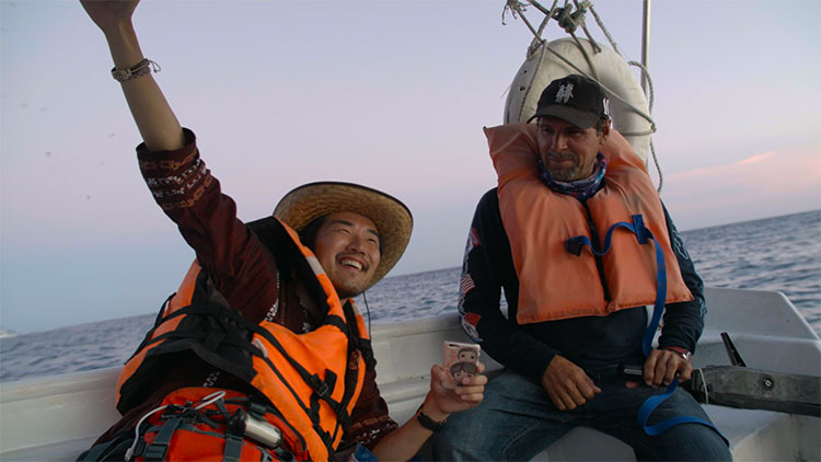
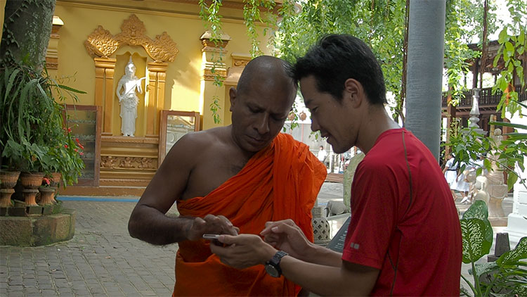
    Above is the STORIES documentary video holiday card, which contains images of Yassan’s journey and the people and places he encountered along the way.


    The daytime version of Yassan's world-stretching art message of peace.
    The daytime version of Yassan’s world-stretching art message of peace.

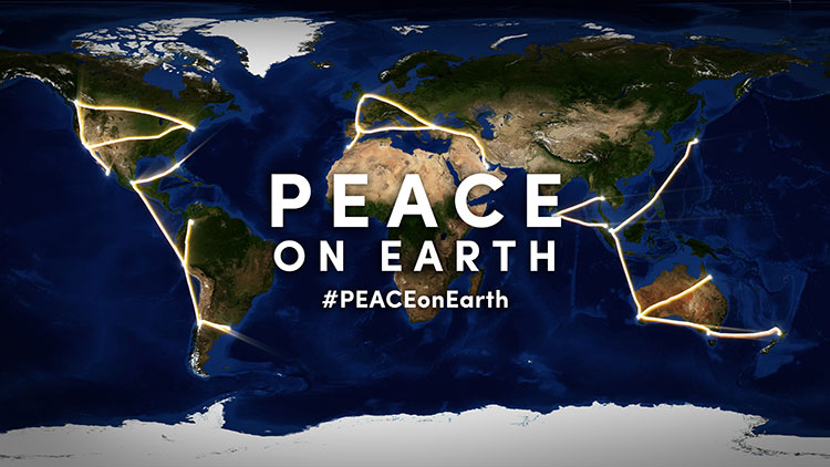
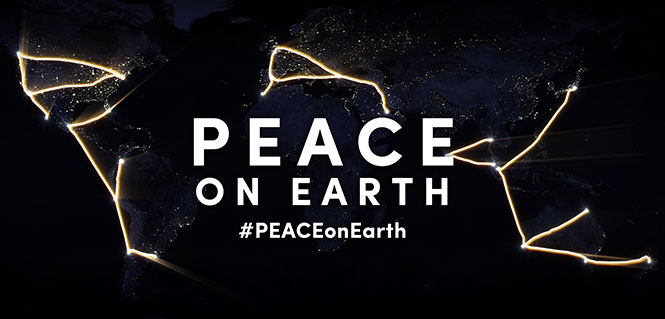
    Peace on Earth: That’s the message spelled out across the globe by GPS artist Yassan in time for the holiday season.

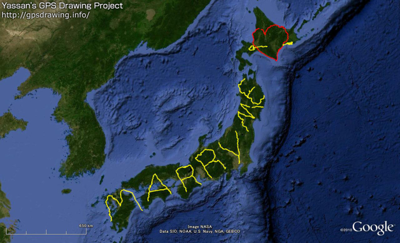
    Yassan created a massive, international work of GPS art around the theme of world peace and, in the process, is attempting to break his own Guinness world record for the largest GPS drawing. Yassan is the Guinness world record holder for the largest GPS drawing by an individual. GPS World previously reported on his “Marry Me” project.

    Yassan visits Times Square in New York City.
    Yassan visits Times Square in New York City, at coordinates 40.7593 ° N, 73.9852 ° W.

    With the help of Japan Airlines and its partners, Yassan’s latest project covered 65,700 miles (105,734 km) around the globe, beginning in Tokyo and ending in San Jose del Cabo, Mexico. He traveled through Asia, Oceania, the Middle East, Europe, Africa and the Americas, and visiting 24 cities on six continents.

    To create his GPS drawings, Yassan carries an iPhone and GPS tracker that records his GPS location data as he travels. He then uploads this information to create a drawing on a map. The finished piece of GPS art — a planetary-scale holiday message for the world — spells “PEACE” across the planet.

    Yassan visits with Buddhist Monks.
    Yassan visits with Buddhist Monks in Colombo, Sri Lanka: 6.9165° N, 79.8568° E

    While a relatively new art form, GPS art is a natural progression stemming from much older, large-scale art forms. “In tracing the history of GPS art, you can draw a clear line of artistic evolution,” said Yassan, “beginning with the ancient Nazca lines in Peru, through Michael Heizer and his work with motorcycle tracks in the Nevada desert, to Richard Long’s walks through the English countryside, to the modern GPS artists.”

    Yassan continues, “Peace on Earth has proven very difficult to achieve, but is, at the heart of it, a very simple concept. I hope that this holiday message can convey this idea to the world.”

    A stop in London.
    A stop in London near Parliament: 51.5007° N, 0.1226° W

    On this journey, a video production crew, led by director and STORIES creator client Mark Apicella, accompanied Yassan, documenting the creation of this artwork as well as the artist’s interactions with local people at each of the 33 stops along this epic journey.

    Yassan makes a stop in Los Angeles with a visit to the edge of the continent, at 34.0074° N, 118.4966° W.
    Yassan makes a stop in Los Angeles with a visit to the edge of the continent, at 34.0074° N, 118.4966° W.
    Yassan celebrates at his final stop to complete the downstroke of the "P," at a place appropriately named “El Fin de la Tierra” — the end of the Earth, near Cabo San Lucas, Mexico: 22.8741° N, 109.8962° W.
    Yassan celebrates at his final stop to complete the downstroke of the “P,” at a place appropriately named “El Fin de la Tierra” — the end of the Earth, near Cabo San Lucas, Mexico: 22.8741° N, 109.8962° W.
  • Ohio State Fans ‘Spell Out’ with GPS — and Dot the I

    Four Ohio State University football fans trekked 19 miles to create the script “Ohio” logo on a GPS tracker. Even more impressive, they used Ohio Stadium as the dot on the “i,” similar to how the tuba player dots the “i” when the Ohio State marching band performs its famous “spell out” half-time routine.

    Reddit user Orweezy and his friends used Google Maps to chart their spell out. “My coworker friends and [I] thought it would be cool to start off the football season by mapping and walking the Ohio Script this past weekend and using the stadium as the ‘I’ dotting. Would anyone be interested in doing this with us next year? Maybe even as a fund raising event for a good cause.”

    He said the project took six-and-a-half hours, including a couple of bar stops.

  • From Marriage Proposals to Holiday Messages, GPS Inspires Artists

    From Marriage Proposals to Holiday Messages, GPS Inspires Artists

    Artists are using GPS to create unique messages.

    In October, Jeremy Wood drove all over the United Kingdom to create a Halloween message, reports Metro. Wood drove a 10,000-mile, painstakingly-plotted route through England, Wales and Scotland in a Vauxhall Corsa, plotting a 264,000 positions on the car’s GPS. Wood linked the positions on a virtual drawing to create a picture that shows bats, ghosts, a spider web, and a pumpkin in a witch’s hat, with the word “Halloween” underneath. The result is the image below.

    SWNS_HALLOWEEN_CORSA_04.jpg
    Photo: VB


    Wood isn’t the first GPS-inclined artist. In 2013, a man in San Francisco equipped with an iPhone and tracking app rode his bike 27 miles around the city. Two and a half hours later, Payam Rajabi had etched a heart shape onto a city map.

    heart-W
    Photo: VB

    But the biggest devotee of GPS art could be Japanense artist Yassan, who in 2010 left behind his girlfriend for six months to travel across Japan, reports VB News. Carrying a GPS device, Yassan covered 7,163.7 km mostly by walking, but with some use of a car, ferry, and bicycle. He then used Google Maps to connect the GPS points he visited, resulting in this unique marriage proposal:

    GPS-drawing-Yassan-proposal
    Photo: VB

    Though he made the journey four years ago, his trek is now being featured in a new ad campaign and documentary by Hi-Tec, a company that makes hiking shoes and boots.

    Yassan has been creating large-scale GPS drawings for years. Yassan was so inspired by the possibilities of GPS art that he quit his job in June 2008 to pursue his passion for making GPS drawings. Learn more about Yassan’s GPS Drawing Project on his website.

  • How to Use GPS to Make a Valentine

    How to Use GPS to Make a Valentine

    Yes, there is a way. According to Krulwich Wonders, an NPR science blog, a man in San Francisco equipped with an iPhone and tracking app rode his bike 27 miles around the city. Two and a half hours later, Payam Rajabi had etched a heart shape onto a city map.

    large-heart-map
    Click to enlarge.

    In 2012, Rajabi had to leave his girlfriend behind in Toronto for a new job. To make sure Clare knew this was a labor of love, Payam included an elevation map of his ups and down in the hilly city.

    This year, Verizon is featuring Rajabi — who repeated the feat for cameras — in a television commercial: