Tag: GPS book

  • Expert Advice: The Impact of RFI on GNSS Receivers

    Expert Advice: The Impact of RFI on GNSS Receivers

    By Fabio Dovis

    Fabio Dovis
    Fabio Dovis

    When subjected to very strong interference, a GNSS receiver can be totally blinded and stop working. This is often the scope of intentional jammers. However, in a number of cases the presence of interference is severe enough to significantly decrease receiver performance, but not so much as to make the receiver lose its lock on the satellite signals or blind the acquisition of the satellite signals.

    Such intermediate power values turn out to be the most dangerous cases, because sometimes they cannot be detected, but lead to a worsening of the positioning performance. The accuracy of the position solution depends on, among others, the quality of the pseudorange measurements and/or the phase measurements. Thus, when radio-frequency interference (RFI) degrades the pseudorange and phase measurements or induces cycle slips on the phase measurements, the accuracy of the position solution will decrease.

    Impact on the Front End

    The front-end filters the incoming signal, demodulating it to the chosen intermediate frequency before performing the analog-to-digital conversion (ADC).  We must consider the presence in the front end of the adjustable gain control (AGC) between the analog portion of the front end and the ADC. When the GNSS band is interference-free, AGC gain depends almost exclusively on thermal noise, since the received signal power is below that of the thermal noise floor. When in-band interference is present, the AGC will squeeze the incoming signal to match the maximum dynamics of the ADC, causing a reduction of the amplitude of the useful signal, which may be lost. This may typically happen in the presence of some kind of wide-band interference (WBI) spread over a bandwidth larger than the passband of the front-end filter.

    With narrow-band (NBI) or continuous-wave interference (CWI), statistics of the digital signal at the ADC output are also affected. In this case the AGC can still compress the input signal to avoid a stronger saturation, but the following receiver stages will have to deal with a GNSS contribution quantized only on lower levels.

    In the presence of stronger interference, even the other components of the front end (filters and amplifiers) may be led to work outside of their nominal regions, generating nonlinear effects or clipping phenomena (in which the signal amplitude exceeds the hardware’s capability to treat them). In both cases, spurious harmonics are generated and mixed with the useful signal in the front end itself.

    Impact on the Acquisition Stage

    If the interference is not driving the AGC/ADC to full saturation, the acquisition module is still able to perform its task, processing the interfered signal to estimate the code phase and the Doppler shift with respect to the local code. The correlation with the local code can be seen as a spreading operation followed by a filter.

    Figure 1. GPS L1 C/A acquisition search space in (a) an interference-free environment and in the presence of (b) –140 dBW in-band CWI; (c) –135 DBW in-band CWI; (d) –130 dBW in-band DWI.
    Figure 1. GPS L1 C/A acquisition search space in (a) an interference-free environment and in the presence of (b) –140 dBW in-band CWI; (c) –135 DBW in-band CWI; (d) –130 dBW in-band DWI.

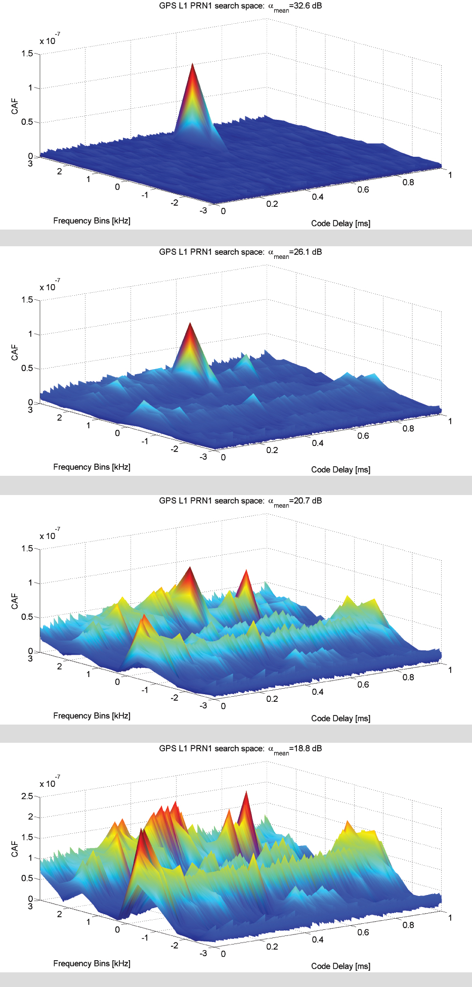
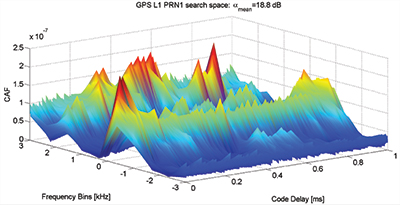
    Figure 1 shows  the acquisition search space for different levels of the  interfering power of a CWI from –140 to –130 dBW compared to the interference-free case. The search spaces depicted for the four scenarios are achieved using 1 ms of coherent integration time and three non-coherent accumulations, and the peak-to-noise-floor separation defined as

    is considered as a figure of merit. The value of αmean decreases as the interfering power increases, thus increasing the probability of a false alarm. With the increasing power of the CWI, a modulation effect in the search space floor in the Doppler domain dimension can be observed. Such an effect is mainly determined by the new harmonics components generated by the multiplication between the locally generated carrier and received CWI. Such an effect also depends on how the interfering signal and the useful GNSS signal are combined at the entrance to the acquisition block, which in turn depends on the random variables φ0 and θint.

    In the presence of WBI, a different effect is observed in the acquisition search space. Considering a band-limited Gaussian white noise spread all over the GNSS useful filtered signal components, the effect on the CAF envelop is an increase in the noise floor. This increases the search space noise floor. The presence of additive band-limited noise causes a uniform increase in the noise floor tin the search space that might mask the correct correlation peak and thus fool the acquisition process.

    Impact on the Tracking Stage

    Interference impact on the tracking stage has a direct consequence on the quality of the measured pseudorange. Harmful interfering signals increase the variance of the time-of-arrival (TOA) estimate by the discriminator and modify the shape of the S-curve of the code discriminator, thus creating in some cases a bias in the measurements. 

    Figure 2 depicts outputs of the early-prompt-late correlators. In the presence of in-band CWI and of NBI, the interference is injected 9.3 seconds after the beginning of the tracking stage where the receiver is correctly locked on the received signal. A CWI, shifted 200 kHz with respect to the signal intermediate frequency (in correspondence with a C/A code spectrum line), increases the noise at the correlators outputs and leads to harmonic behavior of the early-prompt-late correlator outputs.

    Figure 2. GPS L1 C/A code tracing error comparison: coherent and non-coherent early-late processing (CELP and NELP).
    Figure 2. GPS L1 C/A code tracing error comparison: coherent and non-coherent early-late processing (CELP and NELP).

    NBI increases the variance of the correlators’ outputs; this directly increases the pseudorange error and the noise on the receiver phase measurements. Additive band-limited noise leads to an overall increase in the carrier phase discriminator output variance over the 3σ threshold, which for a PLL two-quadrant arctangent discriminator is 45 degrees. When in presence of strong CWI, a sudden jump of the phase discriminator output is detected as soon as the CWI is injected onto the received signal.

    Impact on the Estimated Signal-to-Noise Ratio

    Sticking to the definition of C/N0 as the ratio between the received power and the power spectral density due to thermal noise at the input of the receiver, the presence of interference should not change the value, since the thermal noise is not increasing. However, the C/N0 value provided by the receivers is estimated on the basis of the correlator outputs at the tracking stage. For this reason the estimation is affected by the presence of the additional (nonthermal) noise generated by the interference. The variation of the C/N0 can also be used as observable for interference (or other threats) detection.


    Condensed from Chapter 2 of GNSS Interference Threat and Countermeasures, edited by Fabio Dovis, published by Artech House. This article omits many figures, equations and technical discussions given in book.

    Chapters: The Interference Threat; Classification of Interfering Sources and Analysis of the Effects on GNSS Receivers; The Spoofing Menace; Analytical Assessment of Interference on GNSS Signals; Interference Detection Strategies; Classical Digital Signal Processing Countermeasures to Interference in GNSS; Interference Mitigation Based on Transformed Domain Techniques; Antispoofing Techniques for GNSS. The book is intended for members of the engineering/scientific community with pre-existing knowledge of satellite navigation principles and GNSS.


    FabIo Dovis holds a Ph.D. in elecronics and communications engineering from Politecnico di Torino, Italy, where he is an associate professor.

  • ION GNSS+ 2014: NavtechGPS

    Carolyn P. McDonald, president and CEO of NavtechGPS, catches up with GPS World at the ION GNSS+ Conference September 9-12, 2014, at the Tampa Convention Center in Tampa, Florida. Franck Boynton, vice president and CTO of NavtechGPS, also shares about simulators with software, the company’s OEM presence and more.

  • ‘Flying for GPS’: Memoir of a Pioneer Era — Excerpt

    Flying-for-GPS-JacobsonFlying for GPS, a chronicle of Len Jacobson’s role in the development and promotion of the Global Positioning System, has just been published.
    The book spans a 50-year career, during which Jacobson flew 2.5 million miles as a missionary for GPS and as a developer of user equipment. He kept an extensive log of all of his flights, and it enabled him to recreate in his book much of what happened with GPS during his career, and his impressions of why these events occurred.

    Flying for GPS covers the user-equipment evolution from expensive, complex, and voluminous military sets to today’s low-cost chips buried in our cell phones. It traces a system designed primarily for military and civilian aircraft, ships, and land vehicles to an essential utility of everyday life, enabling new businesses, more safety, and the ability to track everything that moves. It is also a memoir written for the GPS community.

    The book draws from Jacobson’s GPS experience while working for Hughes Aircraft, Magnavox, Interstate Electronics (IEC), and his own company, Global Systems and Marketing, Inc.

    He worked on various assignments from most of the major GPS companies and several small businesses that were trying to find a position in the GPS market. He also participated as an expert witness in many legal cases involving GPS, from patent disputes to accident reconstruction to parolee tracking.

    In parallel with the evolution of GPS, the book chronicles the changes in commercial air travel as Jacobson experienced it, from flying on a PanAm 707 in 1963 to an Air France A380 today. The book is available now from www.xlibris.com, Amazon, Barnes & Noble, and soon from ebook outlets.


    Len Jacobson.
    Len Jacobson.

    Excerpt from Flying with GPS

    By Len Jacobson

    A man in a trench coat borrowed one of our civil GPS Z-sets in late 1979. He couldn’t or wouldn’t say what it would be used for. He suggested that I call over to the Joint Program Office (JPO), and they would verify the validity of the request. A year later I found out what it was all about.

    The Z-set had two boxes, a receiver and a panel mounted control/display unit (CDU). We got the receiver back but we never got the CDU. I learned later that the Z-set had been installed in one of the helicopters used in operation Eagle Claw, the failed April 1980 raid to rescue the U.S. Embassy hostages in Iran. I guess the Special Forces were able to recover the Z-set receiver but not the CDU, as the helicopters were all destroyed.

    I ran a coverage plot for the day of the raid over Iran, and found four satellites were in view at that time. I also received a copy of an Iranian newspaper that had a big article on GPS in Farsi. I couldn’t read it and I don’t think it mentioned the raid, but there was a diagram of the GPS constellation, so I know the Iranians were very aware of GPS. That mission may have been the very first operational military use of GPS.

    Another Covert Role. In September of that same year, a Vela reconnaissance satellite detected a “double flash” that was deemed by many to be evidence of a atmospheric nuclear explosion off of South Africa in the South India Ocean. While many of the details are classified, there is quite a write up about it in Wikipedia, under “Vela Incident.”

    This came at a time when the GPS program was in even greater budget peril than normal. The Secretary of the Air Force at that time was trying to zero out the GPS budget, and it looked very likely he would succeed. But along came a procurement for a Nuclear Detonation Detection System payload package to be placed on all future GPS satellites. I believe that saved the GPS program from a premature demise.

    I also suspect, as do many others, but cannot prove, that the flash was created by an Israeli nuclear test. If so, one might infer that Israel actually, albeit unwittingly, saved the GPS program from extinction.


    Len Jacobson is a retired GPS consultant, having worked in the field since 1968. He is a charter member of the Editorial Advisory Board of GPS World magazine and is also still active in the Institute of Navigation, for which he served as western regional vice president twice and held leadership roles in several of its conferences. He lives in Long Beach, California. Visit his site at www.lenjacobson.com.

  • Jacobson Chronicles Evolution of GPS in New Book

    Jacobson Chronicles Evolution of GPS in New Book

    Flying-for-GPS-JacobsonFlying for GPS, a chronicle of Len Jacobson’s role in the development and promotion of the Global Positioning System, has just been published.

    The book spans a 50-year career, during which Jacobson flew 2½ million miles as a missionary for GPS and as a developer of user equipment. He kept an extensive log of all of his flights, and it enabled him to recreate in his book much of what happened with GPS during his career, and his impressions of why these events occurred.

    Flying for GPS covers the user-equipment evolution from expensive, complex and voluminous military sets to today’s low-cost chips buried in our cell phones. It traces a system designed primarily for military and civilian aircraft, ships, and land vehicles to an essential utility of everyday life, enabling new businesses, more safety, and the ability to track everything that moves. It is also a memoir written for the GPS community.

    An excerpt of Flying for GPS will appear in the July issue of GPS World magazine. In 2013, Jacobson wrote about his early GPS experiences for the magazine.

    Flying for GPS draws from Jacobson’s GPS experience while working for Hughes Aircraft, Magnavox, Interstate Electronics (IEC), and his own company, Global Systems and Marketing, Inc.

    Len Jacobson.
    Len Jacobson.

    He worked on various assignments from most of the major GPS companies and several small businesses that were trying to find a position in the GPS market. He also participated as an expert witness in many legal cases involving GPS, from patent disputes to accident reconstruction to parolee tracking.

    In parallel with the evolution of GPS, the book chronicles the changes in commercial air travel as Jacobson experienced it, from flying on a PanAm 707 in 1963 to an Air France A380 today. The book is available now from www.xlibris.com, Amazon, Barnes & Noble, and soon from ebook outlets.

    Len Jacobson is a retired GPS consultant, having worked in the field since 1968. He is still active in the Institute of Navigation, for which he served as western regional vice president twice and held leadership roles in several of its conferences. He lives in Long Beach, California. Visit his site at www.lenjacobson.com.