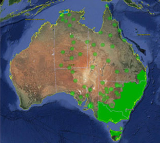
Trimble VRS Now coverage in Australia. Photo: Trimble
Trimble, together with its distribution partner Ultimate Positioning Group, announced the availability of Trimble VRS Now correction service in Queensland, New South Wales, South Australia, Tasmania and Victoria.
Trimble is also now offering the Trimble VRS Now correction service in Oregon’s Willamette Valley.
The commercial subscription service provides surveyors, civil engineers, geospatial professionals and other industry specialists in these areas with instant access to real-time kinematic (RTK) GNSS corrections without the need for a base station.
Using both GPS and GLONASS constellations, the Trimble service delivers centimeter-level RTK corrections customized for each GNSS receiver’s location anywhere in the network via cellular communications. The Trimble VRS Now service supplies accurate, reliable and easy-to-use GNSS positioning for a variety of applications including surveying, urban planning, urban and rural construction, environmental monitoring, resource and territory management, disaster prevention and relief and scientific research, Trimble said.
“The addition of VRS Now to Trimble’s current portfolio of corrections technologies and services in Australia highlights our ability to meet any accuracy, delivery, availability and financial consideration across a variety of applications and markets,” said John Sprivulis, business area director of Trimble’s Positioning Services Division in the Asia Pacific. “Trimble is effectively creating a national positioning infrastructure to meet Australia’s future needs.”
Trimble VRS Now in Australia is a continuation of Trimble’s focus on providing solutions that enable customers to increase productivity by simplifying access to high-precision accuracy around the world. Similar VRS Now services are operating in parts of the U.S. and Europe.
In addition, the Australian VRS Now service supports the Trimble Pivot Field Mobile App, which provides up-to-the-minute information on the VRS Now system status for users in the region.
Because OmniSTAR CORS service in the area is being phased out, existing Australian users will be automatically transitioned to the Trimble VRS Now service, which provides easy access to high accuracy and reliable positioning within the network coverage area.
Service in Australia and Oregon is a continuation of Trimble’s focus on providing solutions that enable customers to increase productivity by simplifying access to high-precision positioning around the world. Similar VRS Now services are operating in Illinois, Indiana, Iowa, Nebraska, Colorado, Florida, Alabama, Mississippi, Texas, and parts of Europe.
In the mass market, individuals around the world are creating vast quantities of location data and GPS traces using not only GPS, but also Russia’s GLONASS, Europe’s Galileo, China’s Compass, and India’s Regional Navigational Satellite System. The value of this data and the value chains that produce it will increase significantly with an increase in interoperability of these satnav systems. Currently, non-interoperability represents a serious obstacle to the growth of the GPS market.
The overall system-of-system’s diversity of data formats, data models, processing models and associated custom- built one-to-one communication interfaces significantly inhibits introduction of new subsystems and also new GPS-dependent systems that would support development of future classes of stakeholders. “Many-to-many” networks based on open standards can create interoperability as well as opportunities for the introduction of new technologies, value-added data products, and new users.
To address this problem, sponsors of the 2012 Open Geospatial Consortium (OGC) OWS-9 Interoperability Testbed, including the U.S. National Geospatial-Intelligence Agency (NGA), documented a set of use cases and associated interoperability requirements, selected strategically to address problems whose solutions would be applicable in a wide variety of GPS value chains.
Technology providers participating in the testbed then implemented standards-based solutions that addressed the requirements. These were documented in a draft Engineering Report, “Use of SWE Common and SensorML for GPS Messaging.” The document focuses on the use of the OGC Sensor Web Enablement (SWE) Common Data 2.0 encodings to support an interoperable messaging description and encoding for the next-generation GPS message streams into and out of processing services that provide improved GPS navigation accuracy.
Standards. The OGC Sensor Web Enablement (SWE) suite of standards specifies models and XML encodings that provide a framework within which the geometric, dynamic, and observational characteristics of all types of sensors and sensor systems can be defined.
Furthermore, through standard web-service interfaces, one can task sensor and actuator systems and have immediate access to observations and alerts. SWE standards, now widely implemented around the world, enable developers to make all types of networked sensors, transducers, and sensor data repositories discoverable, accessible, and usable via the Web or other networks. OGC standards are downloadable at no charge, for use by anyone.
OGC Testbed
The OGC OWS-9 testbed’s OWS Innovations thread included a hands-on prototyping activity that addressed a particular set of interoperability requirements related to GPS accuracy.
GPS relies on accurate knowledge regarding the position, measured time, and state of the satellites, provided to GPS devices and processing centers in the form of satellite ephemeris data and status reports. The accuracy of the system relies on communication between the satellites themselves, the data collection systems, the data processing centers, and the GPS devices that ultimately determine their own location. This communication is through various data streams that consist of predefined message structures and encodings.
The accuracy of the positions derived from GPS can be negatively affected by several well-known factors. Improvements to the derived positions within the current operational system can occur (1) through occasional (once a day or once every few hours) updates to the satellites’ clock and ephemeris on-board information, or (2) through post- processing for applications such as geodetic surveying or image processing and georectification. Efforts are underway to provide more timely updates to satellites or positioning devices to improve the accuracy of positioning in real-time.
The GPS Correction Process
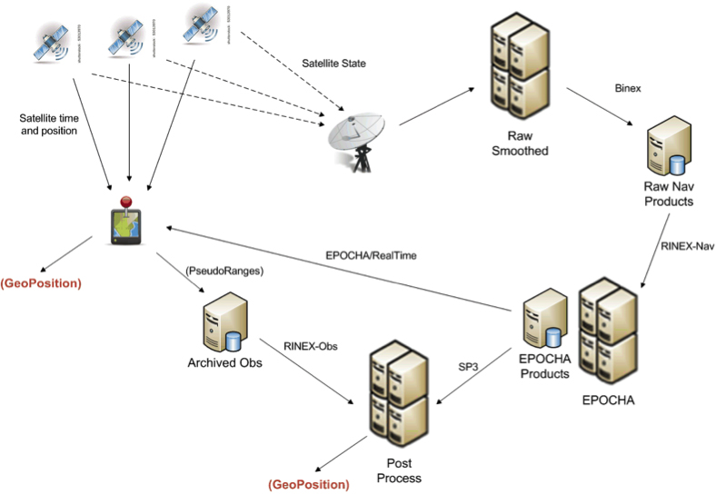
One view of the current system for correcting GPS positioning is provided in Figure 1. A GPS positioning unit (shown as a device with red thumb tack) receives signals from four or more GPS satellites derives its position. In addition, the information being sent by all satellites in the GPS system is also received at various receiving stations, stored as raw navigation data, and used to correct the clock and position information for all of the satellites. The correction process can utilize one or more operational processing systems for correcting satellite clock and ephemeris information. Each of these systems tends to utilize particular data sources and often output their results in different message structures and encodings.
FIGURE 1. Typical flow of data within the GPS correction system.
One such system for correcting the timing and positioning of GPS satellites is Estimation and Prediction of Orbits and Clocks to High Accuracy (EPOCHA). Currently, navigation and timing improvements are only uploaded to the satellites and GPS devices once a day. To improve the EPOCHA system, the National Geospatial Intelligence Agency (NGA) is researching the logistics and benefits of updating the navigation and timing information at much shorter time frames (for example, every 2–15 minutes).
The corrected satellite clock and state data can then be sent to the satellites, to the processing centers to improve geolocation of real-time or archived positions or remotely sensed observations, and to devices in the field to improve real-time position measurements.
A processing system in widespread use for applying these corrections to positional measurements is the open-source GPS Toolkit (GPSTk). This software was used in OWS-9 to demonstrate the processing of SWE Common encoded GPS data within a Web-enabled environment.
As shown in Figure 1, the data flowing between archiving and processing components exist in a wide variety of formats. Currently, these message streams consist of message structures defined through various documents, some of which have restricted access. Additionally, these streams and the messages they contain are being encoded in various formats, including, for example, a binary exchange format (BINEX), a system-specific XML schema, an HDF5 file format, several text-based formats, and others.
The message components within each of these formats are inconsistent, even though two messages may describe similar information. Often a processing system is required to read data and output results in multiple formats and to understand the inconsistencies between them.
By forcing different software and processing systems to support multiple message structures and data formats, the current system inhibits the effective use of these data by:
requiring several format-specific readers and writers to be developed in the appropriate software language (C, C++, Java, Python) as required by each application system;
providing inconsistent message structures between the data used or produced by different processing systems;
requiring meticulous and thus error-prone human interpretation of the data components based on the limited documentation provided for each;
creating lack of interoperability with regard to using data designed for or produced by a different particular processing system; and
discouraging development of new and innovative software and processing solutions.
The Engineering Report addresses the feasibility of using the OGC SWE Common Data v2.0 standard to support all message and data streams within future generations of the GPS operational network. In particular, the effort focuses on message streams that provide input to and output from the processing systems responsible for providing improved position and time accuracy within the GPS network.
Here are the benefits of the SWE Common Data standard:
The data can be fully described in a machine- and human- readable XML document providing: data type, units, constraints, semantics, quality, labels, and so on; and an unambiguous definition of both the data structure and encoding of messages/records.
The data values themselves can be encoded in highly efficient binary or ASCII text blocks or streams.
A single software application is able to read any data described in SWE Common data.
Any process can be described in SensorML using SWE Common as inputs, outputs, and parameters.
Any SensorML-defined process can participate in easily-defined executable workflows.
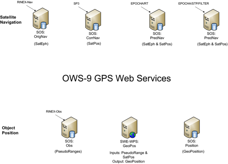
The Engineering Report describes the formats and how they were encoded, and the Web services created to move data between various GPS processing systems (FIGURE 2).
FIGURE 2. Collection of SWE services providing on-demand access to all GPS-related data in the project.
Conclusions
A common standards framework for all data files and streams within the GPS system would significantly improve interoperability between data centers, processing centers, and user tools.
In addition to a common encoding, common models for equivalent message or data records would also be important for interoperability among data, processing centers, and the tools. Common models and a common data framework enable rapid reconfiguration of workflows using different GPS processing products. Likewise, the availability of a common Web service interface enables one to rapidly and flexibly request specific data products and feed them into an executable workflow.
Here are further benefits:
SWE Common Data framework is fully self-described and machine readable.
Common models for all data would support “mix-and-match” capabilities within the processing workflows.
SWE Web services enable on-demand access to various GPS data products using a common framework.
SWE Common Data enables use of SensorML for readily defining and executing various workflows on demand.
Future Directions
Further research and development should move closer to a highly interoperable GNSS system that meets the needs of a broader community of users and enables the development of new supporting software by outside communities. Thus the following are recommended:
Design and reach consensus on consistent data models for all message types in navigation, observation, and state data streams.
Incorporate SWE Common Data readers/writers in the GPSTk toolkit.
Create SensorML descriptions for GPSTk apps.
Demonstrate on-demand design and execution of SensorML-defined workflows for GPS correction.
Demonstrate on-demand geolocation of UAV, ground-vehicle, and hand- held sensors using SWE services and encodings.
Some of these needs will be addressed in the OWS-10 Testbed that is currently ramping up in the OGC.
MIKE BOTTS is president and CTO of Botts Innovative Research, Inc, specializing in the design and application of open standards for sensor systems. He is the creator and chief architect of Sensor Model Language (SensorML), an OGC technical standard for describing the measurement and processing of observations from virtually any sensor system.
Applanix, a mobile mapping and positioning company, is making the Trimble CenterPoint RTX correction service available across its entire airborne mapping portfolio. Applanix is a Trimble Company.
Using the Trimble CenterPoint RTX correction service, Applanix will be able to deliver these benefits to the aerial survey marketplace:
High accuracy — better than 10 cm RMS horizontal after convergence
Speed and low cost — no need for setting up base stations, no need to wait for delivery of public-domain ephemeris data
Simplicity — deal directly with Trimble (no third-party involvement)
More uptime and reliability — use Trimble’s professionally managed, highly maintained private network
Ease of use — there is no additional hardware to purchase, integrate or maintain
Fast and reliable convergence — 30 minutes or less to full accuracy
The announcement was made at Trimble’s China Dimensions User Conference. The CenterPoint RTX service for Applanix airborne mapping products is expected to be available in the fourth quarter of 2013.
“The Applanix aerial mapping portfolio is trusted throughout the aerial mapping community to provide highly accurate position and orientation information for directly georeferencing camera and sensor data,” said Joe Hutton, Director of Airborne Products at Applanix. “By integrating the Trimble CenterPoint RTX correction service, we are maintaining our position at the forefront of accuracy, robustness, and high efficiency in airborne mapping. The CenterPoint RTX correction service gives Applanix products the ability to achieve accuracy required for many types of mapping projects in real time and post-mission, all without the need for base stations – an industry first.”
Trimble CenterPoint RTX correction service is a GPS, GLONASS and QZSS enabled correction service built on Trimble RTX technology. It provides high-accuracy GNSS positioning without the use of traditional reference station-based differential RTK infrastructure.
The solution is also compatible with the Applanix POSPac software to achieve the same level of orientation accuracy as when using base stations, all without the need to have an Internet connection or wait for precise ephemeris data to be available.
Trimble announced today that its Trimble CenterPoint RTX correction service will be available to survey and land administration professionals around the world. Powered by Trimble RTX technology, the GPS, GLONASS and QZSS enabled correction service can offer better than 4 centimeter (1.5 inch) repeatable horizontal accuracy, without requiring the use of a base station or local VRS network.
The announcement was made today at Intergeo 2013, being held this week in Essen, Germany.
In addition to previously announced Agriculture devices, the CenterPoint RTX correction service is now compatible with the Trimble ProXRT for Land Administration and the Trimble R10 GNSS receivers. The worldwide subscription service is expected to be available to geospatial users in the fourth quarter of 2013.
Delivered via L-band satellite, CenterPoint RTX is designed for geospatial professionals who are not using RTK as the primary correction source. Advantageous in remote areas that lack local infrastructure and/or cellular coverage, the corrections are delivered directly to the GNSS receiver. No additional hardware, including radios, antennas, or even cellular data plans, is required to use the correction service.
“By combining global coverage, fast initialization times, and high-accuracy correction data, Trimble CenterPoint RTX offers geospatial professionals unprecedented operating freedom,” said Patricia Boothe, general manager of Trimble’s Positioning Services Division. “We are committed to offering field-proven positioning corrections to address a variety of users’ needs across applications and markets, starting with agriculture and now reaching into the geospatial markets.”
I probably reminisce a bit too much at times, but I can’t help but think back to the ’90s, when obtaining three-meter accuracy via post-processing took a bit of planning. You either had to operate your own GPS base station, or you had to find a publicly available one before you went to the field to make sure you had a source of base station data. Remember, back then publicly available CORS weren’t very common.
Then, towards the late ’90s, there were enough publicly available GPS CORS in the U.S. that you could collect data in the field without knowing where the closest base station was located, but you knew GPS base stations were so prolific that you could find one close enough to use for post-processing without prior planning/coordinating.
Then, sources of real-time GPS corrections started through the same progression. In the ’90s, if you wanted real-time corrections, you either had to operate your own GPS base station and wireless datalink or, if you were lucky you were close to a U.S. Coast Guard beacon transmitter, which were few a far between. OmniSTAR was an option, but subscription was a quite a bit more expensive back then and the equipment was bulky.
Today, post-processing is a no brainer. You don’t even need to have to license post-processing software. Through the National Geodetic Survey’s OPUS, Austraila’s AUSPOS and Canada’s CSRS-PPP, you can collect GPS data anywhere in the world, submit it to one of these free, online processing centers, and have the answer in your email inbox in a few minutes. But, as I’ve lamented more than once over the years, post-processing is a dinosaur. Mind you, it will never go away completely, but it doesn’t belong in the typical mainstream data collection workflow. It just doesn’t make sense.
As it was 20 years ago and as it is today, the challenge with real-time GPS/GNSS data collection is the wireless datalink. If you’ve ever worked with real-time GPS/GNSS data collection and had a unreliable wireless data link between the base and your receiver, you know what I mean. It’s exceedingly frustrating and unproductive. However, when everything is working as designed, the real-time GPS/GNSS data collection workflow is a thing of beauty.
Sources of high-precision real-time GPS/GNSS corrections are still a rather disparate group of public and commercial services that depend heavily on geography and communications infrastructure. For example, in the U.S. there is plenty of wireless coverage (GSM, CDMA, Wi-Fi) in metro areas and along major interstate roads, but there are still vast areas of rural farmland, prairie and desert where wireless networks don’t reach, leaving the choice of either satellite-based communications or setting up your own private wireless communications (UHF/VHF/900 MHz) between a base station and your receiver.
That said, there are more choices for real-time, high-precision GPS/GNSS corrections than ever before. In fact, just last week, the International GNSS Service (IGS) announced that it has started to offer a global real-time PPP data stream for high-precision, dual-frequency GPS receivers via NTRIP. That means anyone with a dual-frequency GPS receiver and an Internet connection can achieve sub-decimeter accuracy anywhere in the world, free of charge. How exciting is that! I think about the regions of the world like South America, Central and Southern Africa, Australia, and parts of Asia that aren’t served well by public SBAS or other free sources of high-precision GPS/GNSS corrections. This service will open up those regions to a new level of real-time, high-precision positioning. There’s one catch though; GPS/GNSS receiver designers have to implement special firmware to use the IGS RT PPP service. Some manufacturers are talking about implementing this, which would be a boon for the high-precision GNSS user community. Global IGS RT accuracy = ~10 cm.
Of course, OmniSTAR, Fugro, Starfire, Veripos have been providing real-time PPP for years (as well as Terrastar and Trimble more recently) in their respective vertical markets (land and offshore) but it requires an annual subscription fee and specialty hardware (L-band) to receive the signal. The receiver hardware can be prohibitively expensive for some potential users, and their coverage, based on leased communications satellite footprint, isn’t dependent on local Internet connectivity. However, I will say that OmniSTAR subscription pricing is very competitive now, and that a public service like what IGS is offering has no guarantees of availability or accuracy. On the other hand, since commercial services like OmniSTAR are collecting a fee, they have an obligation to service their users. Nevertheless, public, sub-meter SBAS services like WAAS, EGNOS, MSAS, GAGAN, and SDCM are offered to non-aviation users on the same terms as IGS, and those services have worked out very well for our surveying and mapping user community.
Other public sources of high-precision GPS/GNSS corrections are on the rise:
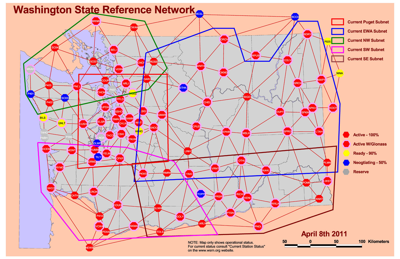
RTK Networks. RTK networks continue to proliferate. In the U.S., many states offer free access to their centimeter-level statewide RTK networks. These are somewhat well-known within the surveying and agriculture community, but not as well known within the GIS community. Many countries also offer regional and country-wide RTK networks. RTK network accuracy = 1-2 cm.
Washington State RTK Network Source: Washington State Reference Network. http://www.wsrn3.org/
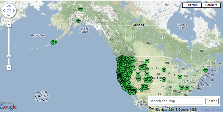
PBO real-time streaming. In the western U.S., UNAVCO’s Plate Boundary Observatory (PBO) maintains more than 1,000 GNSS base stations with many of them broadcasting RTCM3-formatted data. If you’re in California, Oregon, Washington, and the surrounding states, you should take a look at its website. The only requirement is that you have a receiver capable of handling RTCM3 data and you have Internet access in the field. You’ll also need an NTRIP client software (there are free ones available) running on your data collector (smartphone, handheld, tablet). Note that these are single baseline solutions (as opposed to the RTK network solution), so the further you are from the base station, the more error will be introduced. One caveat: be sure you understand which horizontal datum and epoch the particular PBO base station is streaming. PBO real-time streaming accuracy within 20 km = 1-2 cm.
PBO Station Streaming Map Source: UNAVCO Plate Boundary Observatory. http://pbo.unavco.org/data/gps/realtime
CORS Streaming. The National Geodetic Survey (NGS) is testing real-time streaming from nearly a couple of dozen CORS sites, mostly in the Eastern U.S. This is very similar to PBO real-time streaming. If you are 50-75 km from the base station, you’ll still be under 10 cm. If you’re within 20 km, you’ll be down to 1-2 cm.
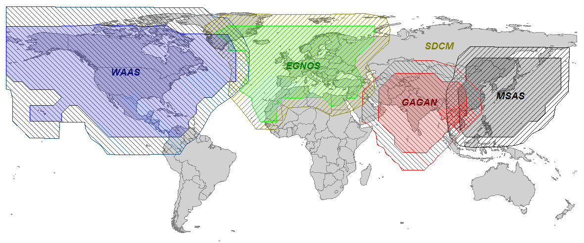
SBAS. SBAS (WAAS/EGNOS/MSAS/GAGAN/SDCM) was the first true source of public, country-wide high-precision GPS corrections. What make SBAS so easy is its ergonomics. It’s become such a standard that virtually every high-performance GPS/GNSS receiver designed today has SBAS capability built-in. You don’t need to purchase any extra hardware or software to use it. SBAS accuracy = sub-meter (with a receiver designed to optimize WAAS).
Global SBAS Coverage Map Source: Geneq, Inc. www.sxbluegps.com
There’s no doubt that years from now, we’ll look back and be amused at how “difficult” and expensive real-time, high-precision positioning was. Today, there are many more sources of high-precision, real-time GPS/GNSS corrections than there were ten years ago. In ten years, there may or may not be many more choices for high-precision GPS/GNSS corrections, but certainly the sources will be less complex, more ubiquitous and more convenient than they are today.
For the latest GPS/GNSS news, follow me on Twitter by clicking here.
Trimble is launching a high-accuracy correction service for the agriculture market. The Trimble RangePoint RTX correction service is expected to be available in March.
According to Trimble, the RangePoint RTX service is an introductory, cost-effective correction service available to farmers across the contiguous U.S. as well as most of Canada, South America, Russia, and the Commonwealth of Independent States, Africa, Asia and Australasia. It’s designed for broadacre agriculture applications. For 2013, all compatible devices — the Trimble CFX-750 display, FmX integrated display, and the AG-372 GNSS receiver — are eligible for an introductory, free 12-month subscription to the RangePoint RTX correction service.
The new service uses satellite broadcast capabilities to deliver real-time accuracies of better than 50-centimeter (20-inch) repeatable, or a superior 15-centimeter (6-inch) pass-to-pass, and does not require the use of traditional reference station infrastructure. Trimble RTX technology supports both GPS and GLONASS satellite constellations, increasing accuracy and reliability for users by leveraging the availability of multiple satellite systems. As a result, the RangePoint RTX service can provide a more accurate, reliable correction solution than some of the traditional Satellite Based Augmentation Systems (SBAS), and is also available in certain geographic areas where SBAS is not currently accessible.
“Trimble is committed to expanding the services and software applications that we provide to the global farming community,” said Mike Martinez, market manager for Trimble’s Agriculture Division. “We recently expanded the availability of real-time, satellite-delivered corrections to most of the world through Trimble’s CenterPoint RTX correction service. Now, we are enhancing the Trimble correction services portfolio by providing an introductory RTX-based option for farmers looking for more accuracy at an affordable price point. Our customers want a broad range of solutions, and we’re delivering those options.”
Trimble RangePoint RTX real-time satellite delivered corrections can be received directly by compatible GNSS receivers, so there are no additional costs for mobile data plans or requirements for additional hardware such as radios and antennas. The RangePoint RTX service is compatible with the Trimble CFX-750 display, FmX integrated display and the AG-372 GNSS receiver.