New BeiDou TMBOC signal tracked
Similar structure to future GPS L1C
China’s new third-generation BeiDou satellites are broadcasting some new signals in space. The newest signal, which just began broadcasting from a satellite launched on Sept. 30, is similar to the future GPS L1C signal with time-division BOC(1,1) and BOC(6,1) signals. Such a type of modulation is called time-multiplexed binary offset carrier (TMBOC).
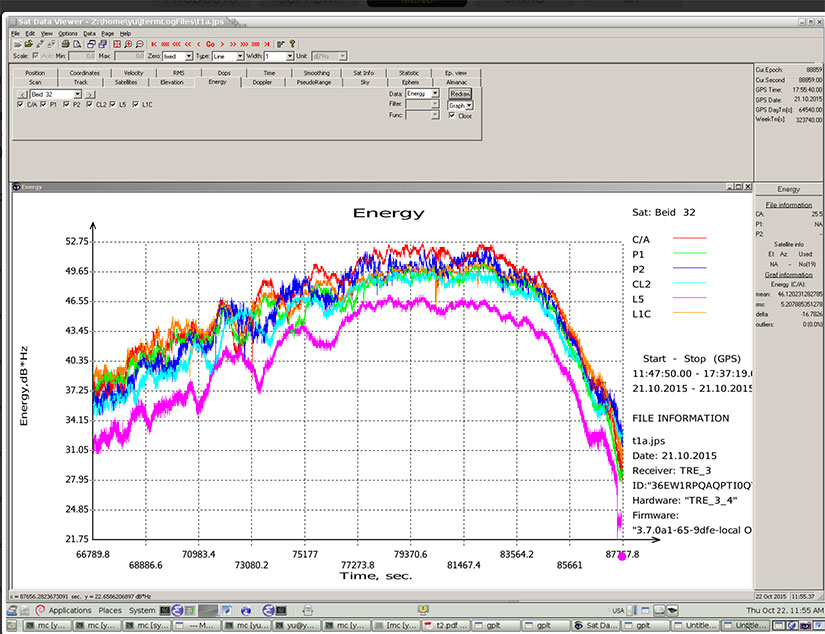
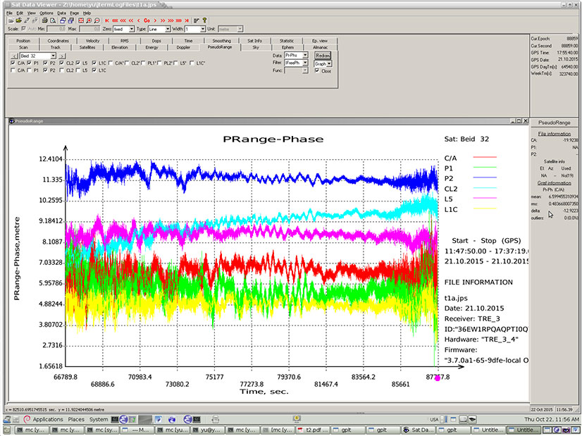
Researchers at JAVAD GNSS have been tracking the new signals, particularly those from BeiDou-3 I2S, an inclined geosynchronous orbit (IGSO) spacecraft, NORAD number 40938. I2S is transmitting on three frequency bands.
The JAVAD researchers used the decoding approach described in their February 2013 GPS World article, “Signal Decoding with Conventional Receiver and Antenna: A Case History Using the New Galileo E6-B/C Signal” by Sergei Yudanov. As a result, the signal’s structure was decoded and L1C TMBOC tracking has been successfully tested on the JAVAD GNSS TRE-3 receiver.
In addition, new signals on 1575.42+1.023*14 MHz (B1-2), 1176.45 MHz (E5A) and 1207.14 (E5B) frequencies for three satellites (PRN 32, 33, 34) also have been decoded and tested. Figures 1–4 illustrate the experiment.
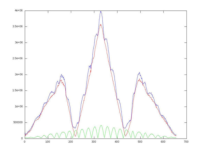
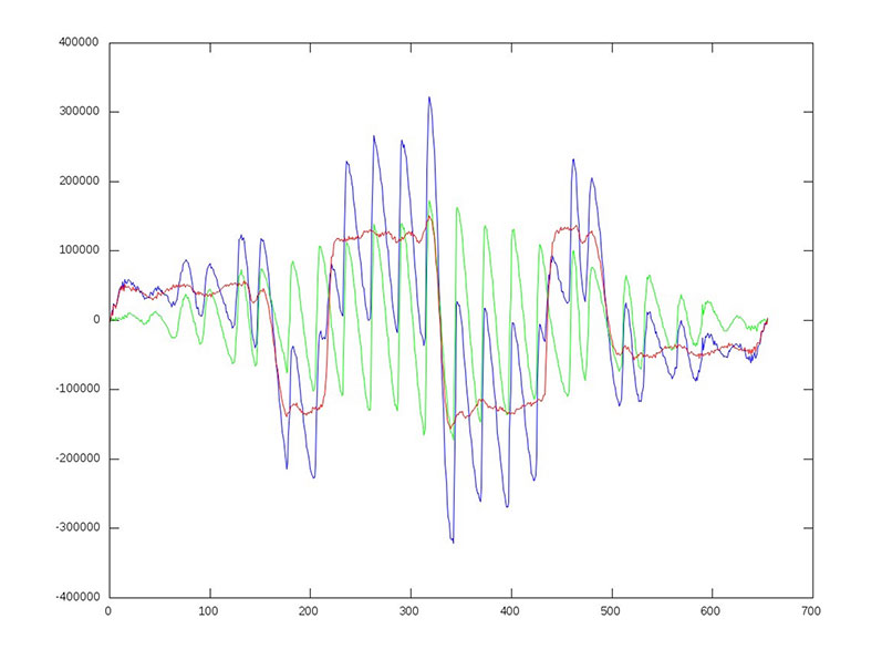
655 – plus one chip shift. C/NO and iono-free “range minus phase.” Slot – BeiDou signal: C/A – B1; P1 – B1-2; P2 – E5B; L2C – B3; L5 – E5A; L1C – L1C.
655 – plus one chip shift. C/NO and iono-free “range minus phase.” Slot – BeiDou signal: C/A – B1; P1 – B1-2; P2 – E5B; L2C – B3; L5 – E5A; L1C – L1C.
Researchers Steffen Thoelert and Michael Meurer from the Deutsches Zentrum für Luf t- und Raumfahrt (DLR, German Aerospace Center) have also been busy tracking the newest BeiDou IGSO satellite. Figure 5 shows a spectral measurement of the complete GNSS L-band frequency range, which shows the signal transmissions on B1, B2 and B3 band. The signal was captured with DLR’s high-gain antenna in Weilheim, operated by the DLR German Space Operations Center in Oberpfaffenhofen.
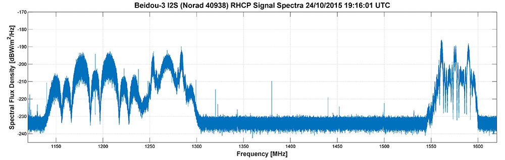
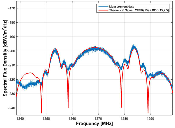
In comparison to the two latest BeiDou-3 MEO satellites, launched on July 25, the IGSO has an additional signal on the B3 band. The MEO satellites transmit only the QPSK(10) while the new IGSO also transmits an additional BOC(15,2.5) signal. Figure 6 shows the B3 frequency band separately including a combined theoretical signal (QPSK(10)+BOC(15,2.5)).
IIF-11 up: penultimate GPS Block IIF satellite
A United Launch Alliance Atlas V 401 launched the GPS IIF-11 mission for the U.S. Air Force on Oct. 31.
GPS IIF-11 is the second to last of the Block IIF satellites, delivering a second civil signal (L2C) for dual-frequency equipment, and a new third civil signal (L5) to support commercial aviation and safety-of-life applications. The next generation of GPS satellites is GPS III.
GPS IIF-11 is the third GPS mission to rise this year. GPS IIF-9 launched in March, and GPS IIF-10 in July. The next satellite, GPS-IIF-12, the last of its generation, is destined for space in early February 2016.
Galileos chirp
Shortly after the Galileo satellite using the E24 PRN code started transmitting on Oct. 10, its sibling began transmitting using code E30. Several stations participating in the International GNSS Service Multi-GNSS Experiment are tracking the new satellites; first among those reporting was the University of Liege, Belgium, using its Septentrio PolaRx4 and PolaRxS receivers to download signals.
The two satellites were launched on Sept. 11. A team of engineers from ESA and France’s CNES space agency are preparing for the next launch, scheduled for December.