Tag: GPS IIF-4

  • Update: GPS IIF-4 Successfully Launched from Cape Canaveral

    Update: GPS IIF-4 Successfully Launched from Cape Canaveral

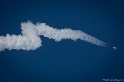
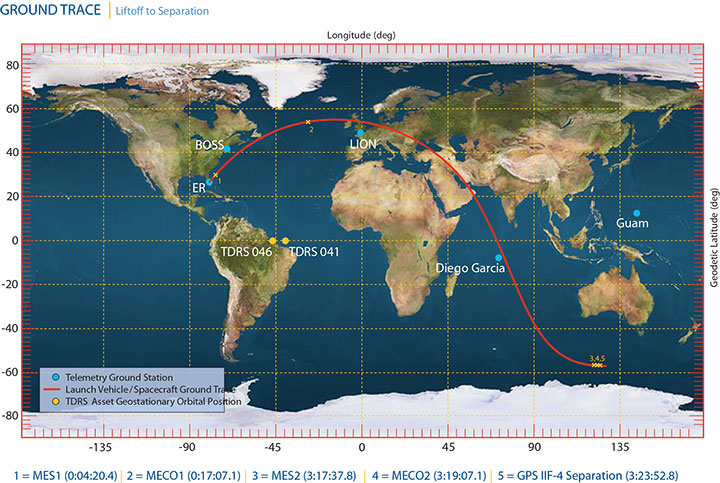
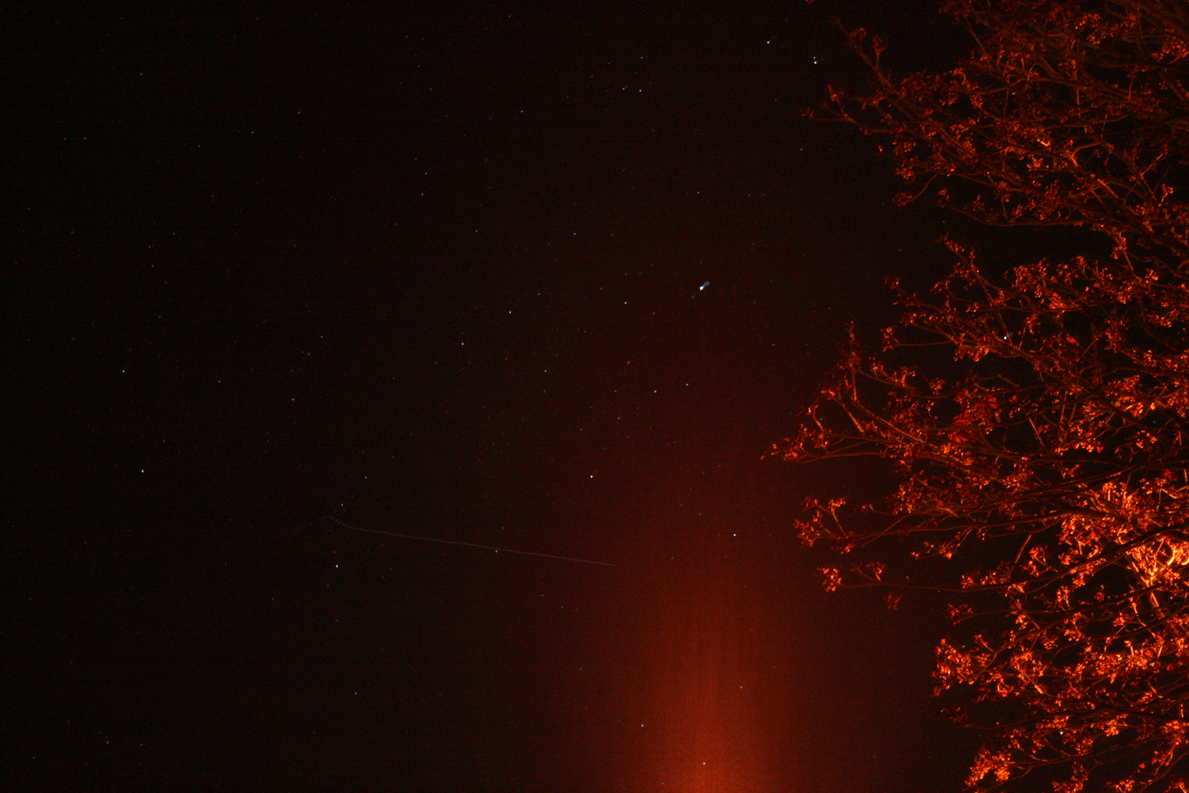
    UPDATE, May 24, by Richard Langley: The Centaur upper stage with the payload still attached was photographed from Tavistock, Devon, in the U.K. by Andy Smith. As can be seen from the ground trace figure in an earlier GPS World news item, the Centaur passed over the U.K. following MECO1, the first main engine cutoff. From Europe, the Centaur could be easily seen by reflected sunlight against the background stars. Its maximum (apparent) brightness magnitude has been estimated as -1 or -2. (Sirius, the brightest star in the night sky, has a magnitude of -1.5; Betelgeuse in the constellation Orion has a mean magnitude of about 0.4; and the limiting visual magnitude for the unaided eye is about 6.)

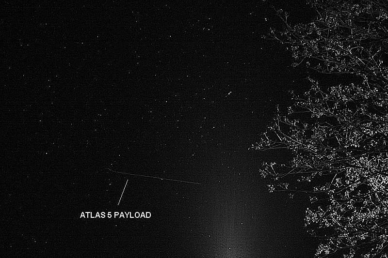
    Smith’s photograph was taken at 21:58:38 UTC (start) with a Canon EOS 450D Digital Rebel camera with an 18-55mm zoom lens. The camera settings were: focal length 55mm, aperture f/5.6, and an exposure of 8 seconds at an ISO value of 1600. Two images are shown below: the original, as obtained from the camera, and a greyscale image with edge enhancement.

    The Centaur can be seen traveling left to right and starts its track as it crosses the constellation of Cygnus. There’s a slight wobble at the beginning as the shutter release was pressed. The glow at the bottom of the frame is from a streetlight. The elevation angle of the Centaur was approximately 12 degrees.

    SVN66 will operate as PRN27 and it will eventually occupy the C-2 orbital slot, replacing SVN33/PRN03, a Block IIA satellite launched in 1996. SVN66 is currently in a drift orbit about 400 kilometers above the operational constellation. It should reach the C-2 slot within a few days from now. The satellite has already been added to the broadcast almanac although it has not yet started to transmit standard signals. It is currently marked as unhealthy in the almanac and will remain so, even after standard signals are switched on, until testing is completed sometime this summer.

    Centaur upper stage with the payload still attached. Photo credit: Andy Smith
    Centaur upper stage with the payload still attached, original photo. Photo credit: Andy Smith

    The same photo digitally enhanced:

    Photo credit: Andy Smith
    Digitally enhanced photo. Photo credit: Andy Smith

    Photo credit: Pat Corkery, United Launch Alliance.
    Photo credit: Pat Corkery, United Launch Alliance.

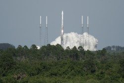
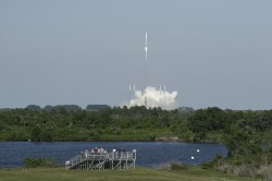
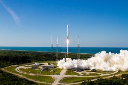
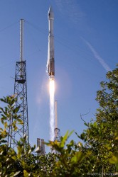
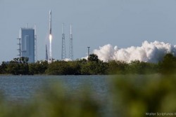
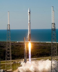
    A U.S. Air Force Global Positioning System satellite built by Boeing was successfully launched May 15. The fourth GPS IIF satellite, Space Vehicle Number (SVN) 66, was carried aboard a United Launch Alliance Atlas V Launch Vehicle at 5:38 p.m. EDT (21:38 UTC) May 15 from Cape Canaveral Air Force Station, Florida.

    The new capabilities of the IIF satellites will provide greater navigational accuracy through improvements in atomic clock technology; a more robust signal for commercial aviation and safety-of-life applications, known as the new third civil signal (L5); and a 12-year design life providing long-term service. These upgrades improved anti-jam capabilities for the warfighter and improved security for military and civil users around the world, the Air Force said in a statement.

    The Atlas rocket took off on schedule. The satellite was released from the Centaur upper stage at T+ 3 hours, 23 minutes and 52.8 seconds or about 01:02 UTC on May 16. Details on the Block IIF satellites and the Atlas rocket can be found here.

    “I’m extremely pleased with today’s launch and delighted to be part of this mission that enhances our nation’s critical GPS capability. Thanks to the superb efforts of the of the 45th and 50th Space Wings, United Launch Alliance, our industry partners, the Atlas V and GPS IIF launch teams, the GPS IIF-4 mission was successfully carried out,” said Col. Bernie Gruber, director of the Space and Missile Systems Center’s Global Positioning Systems Directorate.

    “The GPS constellation remains healthy and continues to meet and exceed the performance standards to which the satellites were built. Our goal is to deliver sustained, reliable GPS capabilities to America’s warfighters, our allies and civil users around the world, and this is done by maintaining GPS performance, fielding new capabilities and developing more robust modernized capabilities for the future,” said Colonel Gruber.

    Here are videos of the launch:


    Opening photo by Pat Corkery, United Launch Alliance.

    Photos show the launch of the U.S. Air Force’s GPS IIF-4 satellite from the Kennedy Space Center and Cape Canaveral Air Force Station.

  • GPS Block IIF-4 Launch Set for Today

    GPS Block IIF-4 Launch Set for Today

    News courtesy of CANSPACE Listerv.

    Update: The launch window for the liftoff has been adjusted slightly to  21:38-21:56 UTC.

    The United Launch Alliance (ULA) Atlas 5 rocket’s rollout to the pad  took place Tuesday. Weather forecasters have predicted an 80
    percent chance of favorable conditions for launch.

    Updates on the mission and live video coverage of the launch is available.

    Live video will also be available here and on this satellite feed (for those of you still with backyard dishes): SES 2, Transp. 21, C-band, 87° West

    ULA is also posting to Facebook and tweeting to Twitter at twitter.com/ulalaunch; look for the #GPSIIF-4 hashtag.


    The next GPS satellite launch is scheduled for May 15 with the launch window extending from 21:39 to 21:58 UTC. An Atlas 5 rocket will be used to place the satellite, GPS IIF-4, into orbit from Cape Canaveral Air Force Station.

    This is the first time in almost 28 years that an Atlas rocket will be used to launch a GPS satellite. All of the prototype or Block I satellites were orbited with Atlas rockets. Since then, Delta rockets have been used exclusively for GPS launches. The IIF satellites are being launched with a mixture of Atlas and Delta rockets.

    The IIF-4 satellite, also known as SVN66, will operate as PRN27. SVN66/PRN27 will eventually occupy the C-2 slot, replacing SVN33/PRN03, a Block IIA satellite launched in 1996. Reportedly, SVN66/PRN27 will go through an extended period of testing following launch, and is not expected to be set healthy until August. SVN33 will become a reserve or backup satellite.

    Ground Stations: ER = Eastern Range; BOSS = Call sign of New Hampshire   Station, New Boston Air Force Station, New Hampshire; LION = call sign   of Telemetry & Command Station, Royal Air Force Oakhanger, Hampshire,   U.K.; Diego Garcia = Diego Garcia Station (call sign REEF), British   Indian Ocean Territory; Guam = Guam Tracking Station (call sign GUAM),   Dededo, Guam. TDRS: Tracking and Data Relay Satellite MES1: Centaur first main engine start MECO1: Centaur first main engine cutoff MES2: Centaur second main engine start MECO2: Centaur second main engine cutoff At spacecraft separation, the GPS satellite's orbit will be circular   with a height of 11,047 nautical miles or 20,459 kilometers and an   inclination of 55 degrees.
    Ground Stations: ER = Eastern Range; BOSS = Call sign of New Hampshire Station, New Boston Air Force Station, New Hampshire; LION = call sign of Telemetry & Command Station, Royal Air Force Oakhanger, Hampshire, U.K.; Diego Garcia = Diego Garcia Station (call sign REEF), British Indian Ocean Territory; Guam = Guam Tracking Station (call sign GUAM), Dededo, Guam.
    TDRS: Tracking and Data Relay Satellite
    MES1: Centaur first main engine start
    MECO1: Centaur first main engine cutoff
    MES2: Centaur second main engine start
    MECO2: Centaur second main engine cutoff
    At spacecraft separation, the GPS satellite’s orbit will be circular with a height of 11,047 nautical miles or 20,459 kilometers and an inclination of 55 degrees.
    (Courtesy of SpaceFlight Now) This is the 45th Launch Support Squadron crew patch for the GPS 2F-4   mission, which is Boeing's Space Vehicle (SV) #5. Each SV is a named   for a navigation star and its constellation. SV-5 is named Vega, with   constellation Lyra. On the patch, they are the large star and   constellation in the background of space. The United Launch Alliance   Atlas 5 rocket is shown lifting the satellite from the Eastern Launch   Site at Cape Canaveral Air Force Station. The Squadron mascot is a   gator, and a lyra is a Greek harp. SSgt Thomas Hogan drew a   "Toga-Gator" and Lt Ken Stuart did the patch design.
    (Courtesy of SpaceFlight Now) This is the 45th Launch Support Squadron crew patch for the GPS 2F-4 mission, which is Boeing’s Space Vehicle (SV) #5. Each SV is a named for a navigation star and its constellation. SV-5 is named Vega, with constellation Lyra. On the patch, they are the large star and constellation in the background of space. The United Launch Alliance Atlas 5 rocket is shown lifting the satellite from the Eastern Launch Site at Cape Canaveral Air Force Station. The Squadron mascot is a gator, and a lyra is a Greek harp. SSgt Thomas Hogan drew a “Toga-Gator” and Lt Ken Stuart did the patch design.