Tag: GPS III launch

  • GPS III SV04 receives operational acceptance, 1 more needed for M-code

    GPS III SV04 receives operational acceptance, 1 more needed for M-code

    The fourth GPS III satellite, space vehicle (SV) 04, received United States Space Force’s Operational Acceptance approval on Dec. 1.

    Operational acceptance marks another significant milestone for the GPS III program, Space and Missile Systems Center and USSF, according to the Space Force. This is the fourth GPS III satellite delivered into the operational constellation in the past 12 months and the second in the past three months.

    Also, this is the first GPS III vehicle delivered to the warfighter through an expedited satellite control authority transfer process, which cuts 10 days off the previous operational acceptance timeline.

    One more to go for M-code capability

    “With the onset of SV04, the GPS constellation continues moving forward in next generation modernization,” said Capt. Collin Dart, the 2 SOPS DOA flight commander. “The 2nd Space Operations Squadron is one step closer to providing military code (M-code) capability for the entire 24 satellite baseline.”

    “The highly encrypted M-code to protect GPS signals from jamming and spoofing is currently enabled on 22 GPS satellites of various generations; 24 are needed to bring the M-code to the next level of operational capability,” Dart explained. “SV04 brings the constellation to 23 M-code capable vehicles. SV05 will launch no earlier than July 2021. This will add the 24th M-code capable vehicle.”

    “M-code signals are more-secure, harder-to-jam and spoof, and are critical to helping our warfighters complete their missions, especially in contested environments,” said Tonya Ladwig, Lockheed Martin’s vice president for Navigation Systems. “GPS III is a warfighting system and we are proud to be helping bring this critical capability to the men and women protecting our nation.”

    GPS III SV04 is encapsulated in its protective launch fairings. (Photo: 45th Space Wing Public Affairs)
    GPS III SV04 is encapsulated in its protective launch fairings. (Photo: 45th Space Wing Public Affairs)

    Faster handover from contractor

    SV04 also sets a new standard for handover from contractor Lockheed Martin’s launch team to operational acceptance, setting the satellite healthy to the global user community approximately 30 days post launch, according to Dart. “Moving forward with future GPS III launches, the timeline between launch and the satellite being set healthy will be at a minimum,” he said.

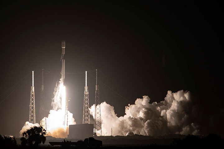
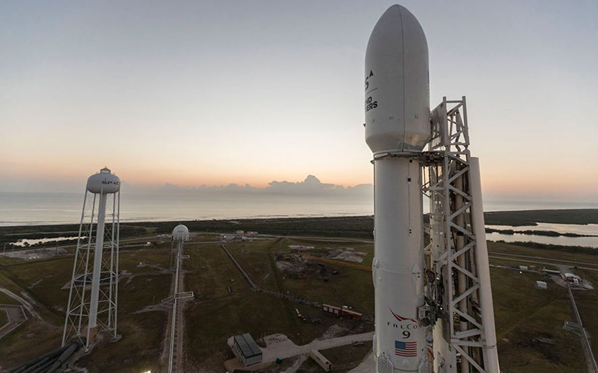
    SV04 was launched on a SpaceX Falcon 9 Block 5 vehicle on Nov. 5. The Air Force has been flying 31 operational satellites for years to ensure the United States’ commitment to have 24 operational GPS satellites available 95% of the time.

    GPS III SV04 joins this operational constellation of 31 GPS satellites orbiting in medium-Earth orbit. The system delivers improved accuracy, advanced anti-jam capabilities and increased resiliency for the GPS III constellation.

    Lockheed Martin’s production proceeds

    The Space Force declared GPS III SV05 “Available for Launch” in May. The satellite is waiting to be called up”for launch.

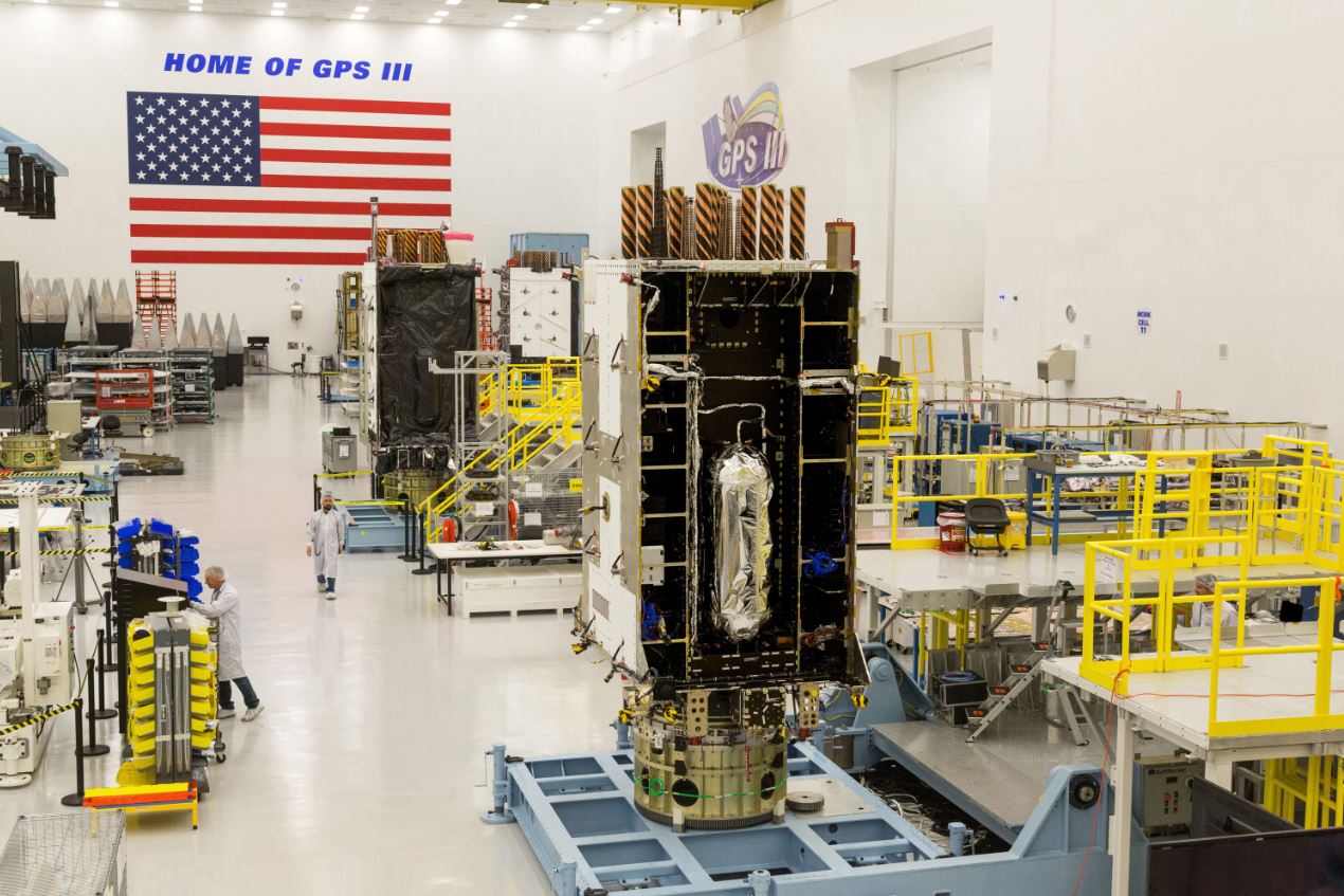
    GPS III SV06, 07 and 08 are now fully assembled and going through environmental testing at Lockheed Martin’s GPS III Processing Facility in Denver.

    GPS III SV09 and 10 are in component build up.

    Lockheed Martin is also under contract for up to 22 additional GPS III Follow On (GPS IIIF) satellites, which introduce further technology and capabilities. In May, Lockheed Martin completed its Critical Design Review for the GPS IIIF and in July, the Space Force declared that GPS IIIF fulfilled “Milestone C,” which means the production phase of the program has officially begun.

    “The operational acceptance of GPS III SV04 is another significant milestone for GPS Modernization, delivering critical new capabilities to our Military and Civil Users. We now have a total of 23 M-code spacecraft for our Warfighters. For our billions of civil users, it brings the count up to 23 L2C spacecraft and 16 L5 spacecraft,” said Col. Ryan Colburn, director of the SMC Portfolio Architect Office’s Spectrum Warfare Division. “For professional users with existing dual-frequency operations, L2C enables faster signal acquisition, enhanced reliability, and greater operating range. L5 is broadcast in a radio band reserved exclusively for aviation safety services. It features higher power, greater bandwidth, and an advanced signal design. Future aircraft will use L5 in combination with L1 C/A to improve accuracy (via ionospheric correction) and robustness (via signal redundancy). The operational acceptance of this spacecraft is another display of the fantastic teamwork across SMC’s Corps, Space Delta 8, National Geospatial-Intelligence Agency, Department of Transportation, Federal Aviation Administration, our industry partners and many others who work together to make these missions possible.”

    GPS satellites provide position, navigation, and timing to more than four billion military and civilian users worldwide.

    A Falcon 9 carrying GPS III SV04 lifts off from Cape Canaveral Air Force Station, Florida, Nov 5. (Photo: SpaceX via USAF)
    A Falcon 9 carrying GPS III SV04 lifts off from Cape Canaveral Air Force Station, Florida, Nov 5. (Photo: SpaceX via USAF)
  • GPS III finally aloft, benefits on the way

    SpaceX’s Falcon 9 rocket orbited the first GPS III satellite on Dec. 23, 2018. (Photo: SpaceX)
    SpaceX’s Falcon 9 rocket orbited the first GPS III satellite on Dec. 23, 2018. (Photo: SpaceX)

    On December 23, the first GPS III satellite entered an orbit around Earth, after a five-day delay. This first of a new breed of GPS satellite also experienced a four-year delay, with its original launch scheduled for 2014.

    While the system has experienced more than its share of problems, at the start of a new year I want to focus on the benefits to come.

    Few of us realized how much our lives would change when the first GPS satellite was launched in 1978. GPS III could bring about a similar trajectory of changes. Civilians can expect a more reliable and accurate service. The smartphone message “searching for signal” could become a dim memory.

    GPS III signals will be three times more accurate than the current GPS Block II models. The navigation payload has more than three times reduction in range error and up to eight times increase in power — its signals should be much easier to pick up under tree canopy, within urban canyons and inside buildings.

    GPS III also has four civilian signals. The L1C signal is interoperable with international GNSS, meaning users can receive signals from any country’s satellites. Also, using two civilian signals means GPS III can directly detect and correct ionospheric errors.

    In addition to a standard wide-angle antenna for broad coverage, the GPS III satellites include a high-gain directional antenna that will operate with 100 times (+20 dB) the power of the wide-angle antenna, and will be exclusively for use with M-code (military) transmissions. This directional antenna’s spot beam covers an area 120 miles at high power— boosting the power of military GPS signals by 100 times in specific regions, making military GPS even harder to jam.

    These advantages may not reach the battlefield for a decade. The new constellation will take time to build. The GPS III constellation is projected to be fully capable in June 2023, when 10 Block IIIA satellites are expected to be in orbit. Ten follow-on satellites are planned to be placed into orbit from 2026 to 2034.

    Back here on Earth, equipment makers will need time to develop and supply warfighters with military GPS user equipment (MGUE) that can take advantage of all that GPS III has to offer.

  • First GPS III launch delayed for rocket issues

    First GPS III launch delayed for rocket issues

    The scheduled launch of the first GPS III satellite on December 18 was scrubbed, reportedly due to first stage liquid oxygen thermal limit constraints aboard the SpaceX Falcon 9 Block 5 launch vehicle’s first stage reaching safety limits. A second attempt on December 19 was later ruled out due to ongoing evaluations into the sensor issue.

    The launch window may open again on Dec. 20.

    This was to have been the first GPS launch aboard a SpaceX rocket, as well as the first SpaceX contracted U.S. National Security mission.

    A Falcon 9 rocket awaits launch. (Photo: SpaceX)
    A Falcon 9 rocket awaits launch. (Photo: SpaceX)

    The first GPS III satellite was originally scheduled to ride aboard a United Launch Alliance (ULA) Delta IV M+ rocket. ULA and/or its prime partners, Lockheed-Martin and Boeing, have conducted every GPS satellite launch since the start of the program. However, due to an assortment of issues variously involving delayed technology development and lawsuits regarding competitive bidding, the Air Force re-opened bidding for the contract as part of its Evolved Expendable Launch Vehicle (EELV) program — “evolved” signifying that the rocket can be recovered and reused.

    Recycling Rockets. ULA did not bid on the re-opened contract, citing concerns over the selection process and potential risks with the anticipated lower launch cost. In 2016, the Air Force selected SpaceX to take over most GPS III launches.

    SpaceX’s Falcon 9 for this launch will use a new first stage core, the B1054. Although it has re-use capability, it will fly in an expendable configuration this time, with no landing legs and no grid fins. It will be disposed of into the Atlantic Ocean after separation from the second stage.

    In other missions, after the satellite-bearing stage separates from the rest of the rocket, the remaining core launcher fires additional fuel to return intact to land or to sea aboard an Autonomous Spaceport Drone Ship (ASDS), a converted barge awaiting in the Atlantic or Pacific Ocean.

    New Generation of GPS.  As attentive readers already know, GPS III SV01 is the first of an entirely new design of GPS satellite that will help the Air Force modernize today’s GPS constellation with new technology and advanced capabilities.

    GPS III has three times better accuracy and up to eight times improved anti-jamming capabilities. Spacecraft life will extend to 15 years, 25 percent longer than any of the GPS satellites on-orbit today. GPS III’s new L1C civil signal also will make it the first GPS satellite broadcasting a compatible signal with other international global navigation satellite systems, like Galileo, improving connectivity for civilian users.

    Lockheed Martin developed GPS III and manufactured GPS III SV01 at its GPS III Processing Facility near Denver. In September 2017, the Air Force declared the satellite “Available for Launch” (AFL) and had the company place it into storage. In 2018, the Air Force called up the satellite for launch and Lockheed Martin delivered it to Florida on Aug. 20. The Air Force nicknamed the satellite “Vespucci” after Italian explorer, navigator and cartographer Amerigo Vespucci.

    GPS III SV01 is the first of 10 GPS III satellites originally ordered by the Air Force. GPS III SV03-08 are now in various stages of assembly and test. In August, the Air Force declared the second GPS III AFL and in November called GPS III SV02 up for 2019 launch.

  • Lockheed preps ground system to support GPS III launches

    Lockheed preps ground system to support GPS III launches

    Once the next-generation GPS III satellites begin launching in December, a series of updates to the current ground control system from Lockheed Martin will help the U.S. Air Force gain early command and control of the new satellites for testing and operations.

    In 2016 and 2017, the Air Force placed Lockheed Martin under two contracts, called GPS III Contingency Operations (COps) and M-code Early Use (MCEU), which directed the company to upgrade the existing Architecture Evolution Plan (AEP) Operational Control System (OCS), which operates today’s GPS constellation.

    The fourth Lockheed Martin-built GPS Ill satellite is fully integrated. (Photo: Lockheed Martin)
    The fourth Lockheed Martin-built GPS Ill satellite is fully integrated. (Photo: Lockheed Martin)

    These upgrades to the AEP OCS are intended to serve as gap fillers prior to the entire GPS constellation’s operational transition to the next-generation Operational Control System (OCX) Block 1, now in development.

    In April, the Air Force approved Lockheed Martin’s critical design for MCEU, essentially providing a green light for the company to proceed with software development and systems engineering to deploy the M-code upgrade to the legacy AEP OCS.

    The Air Force gave a similar nod to COps in November 2016. COps is now on schedule for delivery in May 2019 and MCEU is scheduled for delivery in January 2020.

    “The Air Force declared the first GPS III satellite Available for Launch last year, and it’s expected to launch later this year. Nine more GPS III satellites are following close behind in production flow,” explained Johnathon Caldwell, Lockheed Martin’s program manager for Navigation Systems. “GPS III is coming soon, and as these satellites are launched, COps and MCEU will allow the Air Force the opportunity to integrate these satellites into the constellation and to start testing some of GPS III’s advanced capabilities even earlier.”

    MCEU Capabilities

    Part of the Air Force’s overall modernization plan for the GPS, M-code is a new, advanced signal designed to improve anti-jamming and anti-spoofing, as well as to increase secure access to military GPS signals for U.S. and allied armed forces.

    To accelerate M-code’s deployment to support testing and fielding of modernized user equipment in support of the warfighter, MCEU will upgrade the AEP OCS, allowing it to task, upload and monitor M-code within the GPS constellation.

    MCEU will provide command and control of M-Code capability to eight GPS IIR-M and 12 GPS IIF satellites currently on orbit, as well as future GPS III satellites.

    COps Capabilities

    Following launch and check out, each future GPS III satellite will take its place in the GPS constellation. The COps modifications will allow the AEP OCS to support these more powerful GPS III satellites, enabling them to perform their positioning, navigation and timing missions for more than one billion civil, commercial and military users who depend on GPS every day.

    Besides the addition of GPS III, COps will also continue to support all the GPS IIR, IIR-M and IIF satellites in the legacy constellation.

    Lockheed Martin has a long history of supporting ground systems, providing operations, sustainment and logistics support for nearly 60 Department of Defense satellites, including GPS, often allowing them to double their on-orbit operational design life.

    GPS III Satellites

    Lockheed Martin also is under contract to develop and build 10 GPS III satellites, which will deliver three times better accuracy and provide up to eight times improved anti-jamming capabilities compared to current GPS satellites.

    GPS III’s new L1C civil signal also will make it the first GPS satellite to be interoperable with other international global navigation satellite systems.

  • GPS OCX software ready for 2018 GPS III launch

    Raytheon Company’s GPS OCX program is ready for the U.S. Air Force’s launch of the first modernized GPS satellite later this year.

    Raytheon’s GPS Next-Generation Operational Control System, known as GPS OCX, is in its final software development phase. This phase focuses on increasing automation and building controls for both L1C, a civilian GPS signal aimed at increasing international access, and M-code, a military GPS signal with better anti-jam capability.

    Once complete, the team will begin integration and testing to keep the program on track for full system delivery in June 2021.

    The GPS Operational Control System’s launch and checkout system will control launch and early orbit operations and the on-orbit checkout of all GPS III satellites. (Image: Raytheon)

    “Our team has two primary goals this year,” said Dave Wajsgras, president of Raytheon intelligence, information and services. “We will support the U.S. Air Force’s GPS III launch this fall and complete the software build for the full operational system by year’s end.”

    GPS OCX is the enhanced ground control segment of a U.S. Air Force-led effort to modernize America’s GPS system. The program is implementing 100 percent of DODI 8500.2 “Defense in Depth” information assurance standards without waivers, giving it the highest level of cybersecurity protections of any DoD space system, Raytheon said.

    For protection against future cyber threats, the system’s open architecture allows it to integrate new capabilities and signals as they become available.

    Because GPS OCX can manage nearly twice the satellites of the current system, it will increase signal strength in hard-to-reach areas like dense cities and mountainous terrain.

    Also, advanced automation will free crews to focus on mission-critical tasks such as updating satellite positions more often.

    Learn more about the program’s progress here.

  • System of Systems: Brexit may oust UK from Galileo work

    Brexit May Oust U.K. from Galileo Work

    Participation of the United Kingdom space industry in Galileo may be in doubt as negotiations get underway on details of the U.K. withdrawal from the European Union (EU).

    European Commission officials signaled that they want to rely solely on producers within the European Union for the block’s major programs, citing security concerns such as the possible acquisition of a U.K. contractor by a company from a non-EU country such as China.

    In particular, officials are concerned about protecting the heavily encrypted, jam-resistant Public Regulated Service capability designed for government use that is reserved for EU member states and where U.K. industry has had a significant role.

    Surrey Satellite Technology Ltd., based in Guildford, England, but a subsidiary of France-based Airbus, built 22 navigation payloads for Europe’s Galileo satellite fleet.

    Other companies with U.K. interests that could be affected include Qinetiq, CGI, Airbus and Scisys.


    Galileo SAR Service Launched

    Galileo’s Search And Rescue (SAR) service became officially operational with a public launch on April 6, as part of the COSPAS-SARSAT network for detecting and locating emergency beacons activated by aircraft, ships and hikers. According to the European Commission, Galileo SAR will help reduce the detection delay of a distress signal from up to several hours to 10 minutes.

    At sea, this makes SAR rescue operations easier thanks to a narrowed search box, since the vessel in distress has less time to drift. On land, acquisition of a precise position enables rescue teams to more quickly reach the operation zone and assist the victims. In the air, Galileo contributes to fulfilling International Civil Aviation Organization (ICAO) requirements for implementing the next-generation emergency management system Global Aeronautical Distress and Safety System (GADSS).

    SAR transponders on Galileo satellites can pick up signals emitted from 406-MHz distress beacons anywhere in the service coverage area and transmit this information to the dedicated ground stations, the Medium-Earth Orbit Local User Terminals (MEOLUTs). The SAR/Galileo infrastructure is interoperable with GPS and GLONASS SAR transponders.
    Once the beacon is located by the MEOLUTs, the location data is sent to the COSPAS-SARSAT mission control center, which distributes it to the relevant rescue centers. These then coordinate the required rescue efforts.

    Galileo provides a ground segment coverage of 40 million square kilometers over Europe as a contribution to MEOSAR global coverage. Galileo SAR service is one of the three services launched in December 2016 with the Initial Services. The SAR service represented 1 percent of total Galileo program costs, but should result in thousands of lives being saved, said the European Commission.


    Pile of Studies Produced Not a Lot

    Gen. Shelton
    Headshot: Gen. Shelton

    Testifying before a joint hearing of the House Homeland Security Committee and House Armed Services strategic forces subcommittee on March 29, Retired Gen. William Shelton, the former head of Air Force Space Command, warned that the U.S. needs to take action to protect GPS very soon.

    He cited demonstrated ability by the Chinese government in 2007 to destroy a satellite in orbit, and improved signal jamming and cyber attack capabilities against ground control systems. The U.S. is unprepared to meet those threats, he said.

    “Here we are 10 years later and we don’t really have a lot to show but a pile of studies,” Shelton said. “We’ve been part of this ‘one more study’ kind of attitude. ‘Well, that may not be the perfect answer, so let’s just do one more study’ and meanwhile time marches on. Satellites have fixed lifetimes, and you need to plan for the death of the satellite. A decision not to move forward is a de facto decision to maintain the status quo with no protection.”

    Shelton stated that space research and development is at a 30-year low, with 15–40 percent of R&D funds taken by management services and technical assistance rather than actual research and development.

    “The executive branch and the legislative branch could get together and agree on a strategy and a way forward and then execute … I don’t see any other way. There has to be some broad agreement here in the whole of government as we move forward.”


    June Launch in japan for QZSS Michibiki 2

    QZSS’s second satellite is scheduled for launch in June. Once completed, the Quasi-Zenith Satellite System will be a satellite augmentation system for GPS over Japan and other parts of the Pacific region.

    Michibiki 2 will be launched by the Japan Aerospace Exploration Agency (JAXA), with a launch window planned for June 1–30. The system’s first Michibiki satellite was launched in September 2010.


    OCX Back on Track

    OCX, the next-generation ground control system for GPS, is back on track following a 2016 government contract breach that prompted the Air Force to work with Raytheon to revise OCX’s budget and schedule, according to the company.

    Raytheon implemented a series of corrective actions through 2015 and 2016 to get the delayed program on a firm timeframe for completion. Coding on OCX was about 80 percent complete in late March, according to the company.

    Raytheon completed a re-baselining on OCX in March, setting up a new timeline for completion. Current delivery for the full system is planned for December 2020.

    DevOps. The OCX team reduced development cycle times to create more efficient software development by using a commercial best practice called DevOps, which adds more automation into coding and testing, and breaks coding down into units rather than focusing on the need to finish the complete system all at once.

    A subset of OCX, the Launch and Checkout System for GPS satellites is undergoing testing at Schriever Air Force Base in Colorado. Raytheon expects to complete testing and deliver the system by late September or early October.


    EGNOS Refreshes

    The geosynchrous Earth-orbit (GEO) satellites broadcasting EGNOS messages changed in March. PRN 123 was introduced in the operational platform, and PRN 136 was moved from the operational platform to the test platform.

    Regional aviation in the dense European air traffic system is a key market segment for EGNOS, according to Gian Gherardo Calini, the European GNSS Agency’s head of market development. More than 440 EGNOS-based approaches are available at nearly 220 airports across Europe. These figures are expected to dramatically increase in the coming years.

    A proposal from the European Aviation Safety Agency recommends that air ANSPs and aerodrome operators implement Performance Based Navigation (PBN) approach procedures with vertical guidance (APV), such as EGNOS LPVs, at all non-precision instrument runway ends by 2020.


    Second GPS III Launch Contracted

    The U.S. Air Force has awarded a second GPS III satellite launch contract to SpaceX.

    According to the $96.5 million agreement, the company will provide GPS III launch vehicle production, mission integration, launch operations, spaceflight worthiness and mission-unique activities. Work is expected to be complete by April 30, 2019.

    An earlier SpaceX launch contract, worth $82.7 million, calls for orbiting a GPS satellite aboard a Falcon 9 rocket in May 2018.