Partnering with the U.S. Coast Guard Navigation Center (NAVCEN), U.S. Space Force and Lockheed Martin Space have released the GPS IIR/IIR-M satellite antenna patterns for worldwide public use.
Additionally, the Institute of Navigation has offered a related ION journal article free to the public to accompany the antenna patterns.
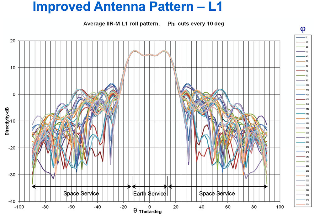
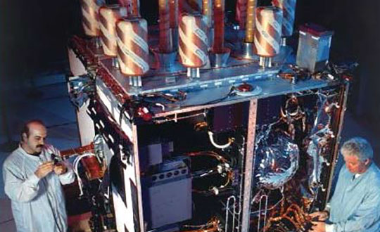
The GPS Block II Replenishment (IIR) space vehicle (SV) began improving upon its baseline design in 2003 with the launch of the first Block IIR SV retrofitted with a redesigned antenna panel. This is the Earth-facing panel providing the GPS L-band broadcast signal. The improved antenna panel includes redesigned L-band elements mounted on the SV Earth-facing structure in the same manner as the original antenna panel.
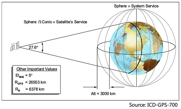
The Earth Terrestrial Service Volume is the near-Earth region up to 3,000 km altitude. (Diagram: NAVCEN/Lockheed Martin)
Spacecraft Navigation
The use of GPS signals for spacecraft navigation has increased in general over the last few decades. Navigation employing GPS observations for spacecraft in low-Earth orbit is now considered routine.
However, the situation is quite different for spacecraft that fly in the Space Service Volume above the GPS constellation, including medium-Earth orbit (MEO), geostationary orbit (GEO) and high-Earth orbit (HEO) satellites, as well as missions to the Moon and beyond.
For these spacecraft, reception of GPS transmit antenna side lobe signals is essential to improve availability and performance of on-board navigation and timing. In this context, the knowledge of the full antenna pattern (main lobe and side lobes) from the transmitting antennas of each of the GPS satellites is essential.
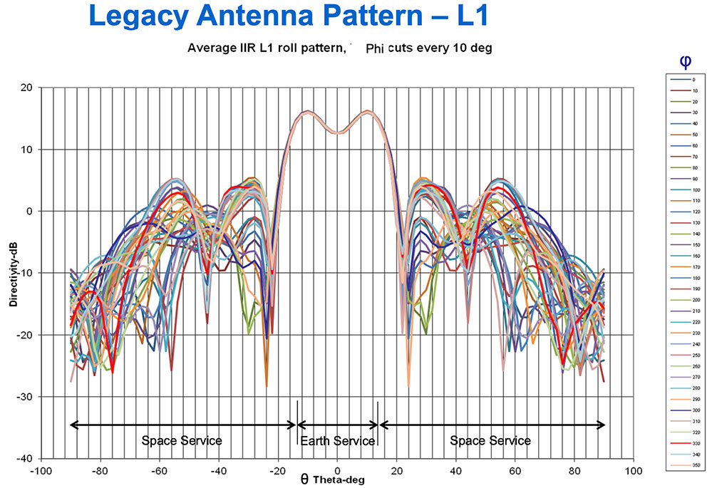
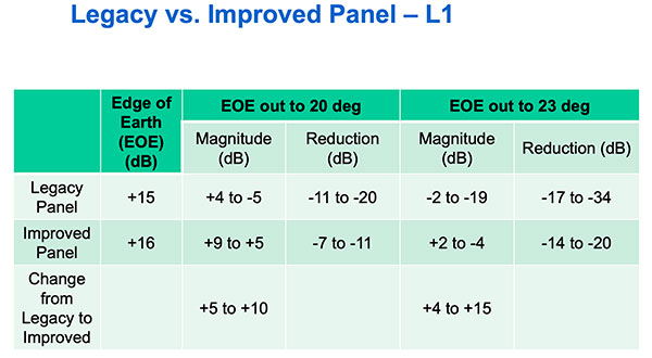
These published antenna patterns and associated ION citation describe both IIR and IIR-M antenna panel versions, their broadcast signal patterns, the performance observed in factory testing, and their on-orbit performance.
Chart: NAVCEN/Lockheed MartinChart: NAVCEN/Lockheed MartinChart: NAVCEN/Lockheed Martin
These patterns represent the current capability of the GPS IIR/IIR-M Space Vehicles. Receiver designers should consult the IS-GPS-200 specifications for use in receiver design and not base design on current signal performance.
GPS technical documents are also available at the NAVCEN website and linked from the GPS.gov website.
Legacy antenna panel on the GPS IIR satellite. (Photo: NAVCEN/Lockheed Martin)
Are you using a legacy-model PNT (position, navigation and timing) receiver or a smart PNT receiver, and why does it matter? Don’t have a clue? Read on! Hint — L2C and CNAV (civilian navigation message format) are the major reason it matters. Yes, it’s all because of L2C, the controversial GPS civilian signal that seems to always be in the news and just keeps getting better the more we learn about it.
A couple of weeks ago, Alan Cameron, our esteemed editor in chief — penned a follow-on editorial comprised of excerpts from techies, subject-matter experts and editors, including yours truly, exchanging opinions about the flexibility, sustainability and capability of the GPS L2C signal and all that signal enables.
I won’t bother to go into the details or history of the L2C signal here, as I did that in excruciating detail 30 months ago. However, let’s consider L2C 30 months on and determine if the landscape has changed.
What is L2C?
According to the official U.S. government PNT website, “L2C is the second civilian GPS signal, designed specifically to meet commercial needs.” As it turns out, the military needs L2C as much as the civilian world, but that is a story for another time. When combined with L1 C/A (coarse acquisition signal) in a dual-frequency GNSS receiver, L2C enables ionospheric corrections, a technique that boosts accuracy. Civilians with dual-frequency GPS receivers typically enjoy the same or better accuracy as the military.
For professional and high-precision users with existing dual-frequency receivers, L2C delivers faster signal acquisition, enhanced reliability and greater operating range. L2C broadcasts at a higher effective power than the legacy L1 C/A signal, making it more jam and interference resistant, plus it’s easier to receive signals under trees and indoors. The U.S. Commerce Department estimates L2C will generate about $6 billion in economic productivity benefits through the year 2030. Considering there are more than four billion GPS users around the world today, the DOC economic benefits number seems rather low.
L2C Status
The first GPS IIR-M (R= Replenishment, M= Modernized with M-code and L2C) satellite featuring L2C launched on Sept. 26, 2005, and is still operational today. Every GPS satellite fielded since then (18 SVs, including SVN 49) has included an L2C transmitter. This equates to 16 operational L2C satellites on orbit and transmitting, with GPS IIF-10 being number 17 when it is fully commissioned. With 17 SVs (GPS satellite vehicles) on orbit, the L2C system is officially near Initial Operating Capability (IOC). With the requisite ground system upgrades, which are in the works, this means that on any given day most users will have at least one or more L2C signals in view. You can be sure manufacturers will be quick to take advantage of the geometry.
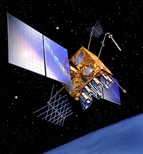
LMCO GPS IIRM Satellite Vehicle On Orbit. (Artist’s rendering courtesy of Lockheed Martin)
Legal Caveats
“In April 2014, the U.S. Air Force began broadcasting civil navigation (CNAV) messages on the L2C and L5C signals. Prior to that time, L2C and L5C provided a default message or Message Type Zero, containing no data. Adding additional CNAV message types required upgrades to the GPS control segment. On Dec. 31, 2014, the Air Force began transmitting CNAV uploads on a daily basis. L2C should continue to be considered pre-operational and should be employed at the user’s own risk.”
Now the lawyers are happy.
So What?
What does this mean for the average user? You might be surprised at the answer. Depending on how technical you are and exactly how you use GPS, it could mean that all your “legacy” GPS receivers are about to become obsolete. Or, depending on the company that builds your receivers and the amount of foresight they built in, it could just mean a few firmware upgrades and new applications.
Regardless, with the full implementation of L2C GPS signals and navigation messages, GPS will never be the same again. This is not to say your legacy receiver will not work just as efficiently as it does today, and in fact you will probably be able to use it quite effectively for years. But it will not be able to take full advantage of all the capabilities L2C enables without an upgrade, if indeed it is upgradeable.
Legacy versus Smart
No matter how much or how little you paid for your GPS/GNSS/PNT receiver, it is essentially — except for a few notable exceptions — a legacy receiver. For example Trimble is ahead of the game as they began producing L2C capable receivers as early as 2003 and are just waiting for the additional L2C messages to be defined. Again, those receivers that are not L2C-ready or capable are what I will classify as a legacy receiver, simply because of all the future capabilities that are missing. Your current PNT receiver may have the potential to be a smart receiver — it may have the technical capability to process far more than it does today. But, unfortunately, essentially almost every receiver, again with a few exceptions, on the market today falls into the “legacy ” category.
Is My Legacy Device Considered Obsolete?
Now that I have your attention and have probably riled more than a few GPS device manufacturers, please allow me to explain. In the past, your GNSS/PNT device (for brevity’s sake, I will default to PNT for the rest of the column) has basically performed a simple function. It displayed your position, and perhaps maps and other ancillary data (targets or destinations) after it received, decoded, verified and applied timing signals and a very small number of navigation messages.
It accomplished this feat typically from a cold start in under 120 seconds. Maybe much less. Recently, I was privileged to view a demonstration of a receiver from a major manufacturer that performed a warm restart in less-than-ideal conditions and displayed a useful position in 1/20th of a second. As amazing as that may be, it is still today classified as a legacy receiver. It accomplished its task; it supplied a useful position both in human and machine language that could be utilized by both. In the past, this was the task your receiver accomplished routinely. With the full implementation of L2C, all that changes and changes drastically. I call it a revolution for PNT, but alas I am frequently given to hyperbole. However, give me a moment and see if you don’t agree.
I was attracted to a Wall Street Journal headline recently by a company that I know well, since they have an abundance of well-known and multi-talented former military leaders. That company, Accenture, puts it this way: “Change is good. Transformation is even better.” That is exactly where I believe we stand today with L2C. It is a game changer.
For example, just this week in the WSJ, which I read cover to cover six days a week, I saw stories about Audi vehicles driving autonomously from coast to coast, over 3,000 miles without driver intervention. Contrary to many manufacturers, Audi is quick to credit GPS with a large portion of the proprietary Audi (VW) technology and the capability it enables. There was a story about commercial vehicles, over-the-road diesel trucks that may have even more capabilities than the Audi. Again, with GPS as the prime contributor. The same WSJ story mentioned that, “Some of the features being added to trucks are similar to those in cars, but generally the move to autonomy in commercial and industrial vehicles is far ahead of the autonomous systems offered on most passenger vehicles. Already, mining vehicles and military forklifts are operated without drivers.”
Amazingly, these capabilities depend greatly on GPS, but exist without the full implementation of the revolution that L2C, CNAV and multiple nav messages will bring.
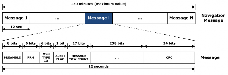
L2C CNAV Message Structure.
L2C Ready
I have over the past year seen advertisements for PNT devices that proclaim they are L2C ready. I beg to differ, but only because my definition of L2C ready probably varies greatly from that of the devices’ marketing department. Beyond its signal structure, L2C has a new messaging capability.
As stated earlier, the L2C signal is heads and shoulders above most other GNSS signals in strength, code structure and security. L2C delivers faster signal acquisition, enhanced reliability, and greater operating range. L2C broadcasts at a higher effective power than the legacy L1 C/A signal, making it interference and jam resistant and easier to receive under trees and indoors. These attributes make it a great signal and when you consider the carrier-phase and RTK (real time kinematic) capabilities, which really are real-time today. It is a very appealing signal indeed.
For precision and timing users, the carrier phase of the L2C signal, non-coded carrier, is 1,000 times more stable than the fully coded L2C signal. The L2C carrier-phase stability will remain unchanged until the semi-codeless transition date of Dec. 31, 2024, per the FRP or Federal Radio Navigation Plan of 2014. Then officially all bets are off, but who knows? That date could be extended.
However, the real and future strength of the L2C signal structure is hiding in one or more (accurately 255 more, for a total of 256) messages that can be utilized in a myriad of ways and applications. These are messages, nav-messages if you will, that your new or updated PNT device will be able to utilize for who knows how many functions. Just use your imagination. Here are some ideas I have for using the additional L2C messaging capability.
Send 250+ other navigation messages, to be defined.
Send continuous atmospheric corrections (such as ionospheric) for each two degrees of longitude around the globe or in one degree increments if you consider land mass applications only.
John Deere and Trimble as the leading commercial and civil providers of navigation data could appropriate a small fragment of the messages for their global navigation and timing corrections to their agricultural and precision users/customers around the globe.
Companies or governments could send nominal navigation or even text-based navigation-related messages to users anywhere an L2C signal can be received.
Companies could shut down and render useless receivers from users that have not paid their bills or were abusing the system.
Companies could send small firmware updates or notices of larger updates directly to users. Data could include active hyperlinks.
Precision, scientific and premium users might have the capability to receive constant correction updates that make their PNT receiver a centimeter or potentially a millimeter level device.
Receivers with communications — four billion plus smartphones and other devices with PNT capabilities and built-in communications — could become sensors capable of being sampled at will. These devices have the potential to be considered remote monitoring stations both for PNT and communications purposes. They could report both communications and PNT jamming or interference. They could also help track intentional jammers.
If you think about it hard enough, you will see that this modest list of capabilities with the proper security either make spoofing an impossibility or without proper security a malicious nightmare.
I hope by now you catch my drift and have come up with some ideas of your own concerning how the additional 250+ L2C messages could be utilized. We’re unsure how many messages will actually be available or how the messages will be used. The government will, out of operational necessity, require a small number, so right now your guess is as good as mine.
Keep in mind that L5C and M-code will have the same capabilities on differing frequencies, and different governing bodies will decide how the signals and 750-plus multiple-messaging capabilities are allocated and utilized. That is all hopefully in the near future. How that process unfolds, technically and operationally, will have a great deal to do with how successful and ubiquitous L2C becomes. The process alone will undoubtedly spawn thousands of articles; however, right now we are primarily discussing the necessity for smart receivers to fully utilize the additional L2C messages. For along with all the potential capabilities comes a processing and communications tail that does not exist today, except in a few instances that we can’t go into in this venue.
Relative
This is probably a good time to further qualify what I mean by legacy versus smart receivers. Were the appellation “legacy” not already in our vernacular concerning today’s highly functioning devices, it would not be one I would have chosen. However, it is and we are stuck with it. Consider that there are static high-end (read premium quality) single GNSS receivers that “see” more than 50-60 separate GNSS satellite vehicles and processes more than 150 GNSS signals. This does not take into consideration all the augmented and companion signals some of these devices are capable of processing. Many of these devices are very difficult to jam and literally cannot be spoofed, and still today they are legacy receivers in relationship to L2C capabilities.
However, I am told such high-end receivers are absolutely L2C ready, which may mean the additional L2C messages are ready to be processed and applied, received or rejected, whenever they are properly and officially defined. This brings us to the future definition or next generation smart L2C receiver.
Smart L2C PNT Receiver
For the first time a smart PNT L2C capable receiver will have the ability to:
Select between GPS only, GPS + GLONASS, or full GNSS mode with ancillary corrections such as WAAS and EGNOS, and work with, process or reject messages, making a decision about some or all the signals it has in view. While there are receivers that accomplish some of these functions today, they do not typically have the option of accepting or rejecting a GPS navigation message if it is properly formatted and verified. L2C smart receivers will — indeed must — at a minimum possess and correctly utilize that capability.
Alert users concerning new navigation message(s) and determine automatically or with user input whether the navigation message should be applied immediately, in the near future, put on hold or totally rejected.
Alert users to the effect that applying new or multiple navigation messages will have on the current PNT display and possibly the current mission or operation. For example, if you are a precision user, think millimeters for level of accuracy, utilizing PNT to measure tectonic plate movement — you are very interested in relative displacement over time and you may have no desire to apply a multiple nanosecond correction that could move your current measured position several inches or feet. If you are a geocacher, you do not want the coordinates of your latest buried treasure to dynamically change.
Determine if the latest valid navigation message(s) apply to your geographic area or, for mobile receivers, your destination, and what effect incorporating the messages will have on your displayed position or ETA.
Display a text-based navigation message if it is addressed to your device.
Require password(s) for certain actions — be they sensitive, proprietary, classified or of a “cannot undo” nature. Passwords could also be required in the message format before it could be unlocked and applied.
Determine and alert users if multiple navigation or device-control messages conflict with organizational or user-defined parameters.
Alert users to malicious messages or spoofing attempts.
Alert users to GNSS assets that are no longer available or go offline, such as during the two total GLONASS constellation shutdowns when GLONASS signals were not available for several hours. In the case of Apple iPhones, the GLONASS constellation-wide shutdown meant these devices went from multiple GNSS devices to “GPS plus PNT augmentation (WAAS) and other onboard sensors” devices. This is something many users may not care about, but is definitely worth a user-defined parameter for a warning message.
The ability to permanently reject a certain type of message by type, source, timeframe, etc.
By now, I hope you see the trend. You can probably think of many more possibilities for future GNSS or PNT receivers and the necessity for them to be loaded with computing and communications capabilities, especially where L2C is concerned — indeed, where all the CNAV signals and messages are concerned.
Bottom Line
The bottom line is L2C is a potentially revolutionary signal for GPS/PNT; it opens incredible opportunities for entrepreneurs, manufacturers and users at a minimum. We now all have some hard and important questions to consider before we purchase our next-generation PNT device or upgrade our legacy device.
Until next time, happy navigating, and I hope to see everyone at ION GNSS+ in September in Tampa, Fla. Remember, GPS is brought to you courtesy of the United States Air Force.
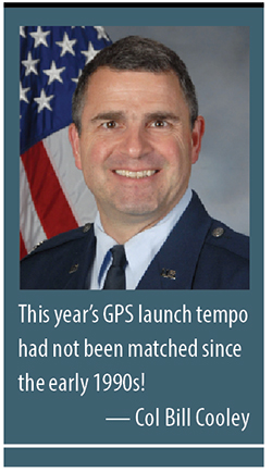
By Colonel William T. “Bill” Cooley, U.S. Air Force, Director, Global Positioning System
Last year in my “Directions” article, I emphasized the commitment made by the U.S. government to ensure GPS signals are available to all users, and I shared some of our excitement in the GPS Directorate regarding the modernized capabilities we are developing and fielding. This year I’d like to share with you progress we’ve made in the past 12 months, provide an update on the modernization initiatives, and challenge civil users and receiver companies to innovate and accelerate these modernized capabilities for users worldwide.
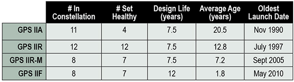
This past year has been productive for the GPS program. The most visible progress was the addition of four new Boeing-built GPS IIF satellites to the GPS constellation, bringing the total number of available satellites from 36 to 39 (SVN-33 was safely disposed in October 2014, or the number would be 40). These additions also reduced the average age of the satellites on orbit from 11.1 to 10.3 years. This year’s GPS launch tempo had not been matched since the early 1990s! Table 1 lists the current satellites in the constellation by block.
TABLE 1. GPS constellation as of October 31, 2014.
Perhaps the most exciting aspect of the GPS satellite constellation is the ever-improving performance. As I mentioned last year, the 2008 Standard Positioning Service (SPS) Performance Standard, issued by the Office of the Secretary of Defense, codifies our commitment to civil users. Among other attributes that make GPS the “gold standard” for positioning, navigation, and timing (PNT), the SPS requires a signal-in-space (SIS) user range error (URE) of 4.0 meters or less for every healthy satellite. The SIS URE is the difference between a GPS satellite’s navigation message (for example, ephemeris data and satellite clock correction data) versus the truth (for example, satellite transmit antenna location and satellite clock offset from GPS time). While the commitment of the U.S. government is four meters or less, the actual average performance over the past year has been 0.68 meters and in the past quarter has been an impressive 0.63 meters!
While this is admirable, continued modernization efforts will allow us even better performance. A significant contributor to the errors experienced by GPS receivers are ionospheric delays that can be eliminated only with knowing the characteristics of the ionosphere (free electron density in the region roughly 100-1,000 kilometers above the Earth’s surface) or by using two signals at different known frequencies. While systems like Federal Aviation Administration Wide Area Augmentation System (WAAS) and the U.S. Coast Guard National Differential GPS (NDGPS) provide a modeled approximation of the ionosphere, the new L2C and L5 civil signals on the GPS IIR-M, GPS IIF, and soon-to-launch GPS III satellites enable GPS receivers to directly measure and eliminate the ionospheric delays altogether — thereby delivering on the GPS modernization program first announced in 1999. These new signals began pre-operational Civil Navigation (CNAV) message broadcast on 28 April 2014 (with the L2C signal set “healthy” and L5 set “unhealthy” until sufficient monitoring capability is established).
With CNAV now on the air, civil users should take advantage of it. My challenge to commercial receiver companies and innovators is to incorporate the modernized signals in future receivers and continue to improve user experience and GPS performance. Currently 14 L2C-broadcasting satellites are in the constellation, and by early 2016 we expect to have 19 on-orbit and transmitting L2C (7 GPS IIR-Ms and 12 GPS IIFs). GPS modernization is well on its way from a signal-in-space perspective; receiver manufacturers and innovators must bring new, improved products and solutions to users.
Less visible but real progress modernizing the GPS Enterprise is underway with the next generation of GPS satellites, ground control, and user equipment segments. The first GPS III satellite and the newly developed navigation payload have been delayed approximately two years from the original planned delivery of the completed GPS III satellite of October 2014. But in September of this year, the GPS III navigation payload was shipped from Exelis (the payload subcontractor) in Clifton, New Jersey, to Lockheed Martin’s (GPS III prime contractor) facility in Waterton, Colorado. There, it completed the payload-level thermal vacuum testing at the end of October, a key step toward payload and eventually satellite vehicle delivery. The first GPS III satellite is now 87% complete and the program is making solid progress.
The GPS Next-Generation Operational Control System (OCX), with Raytheon as the prime contractor, experienced significant challenges in development but can also claim measurable progress this year. Complex cyber-security requirements and their implementation drove a significant number of these challenges, but are essential to provide civil and military GPS users with a secure and resilient command and control system. These and other challenges resulted in significant cost and schedule overruns and a two-year delay to the program, which drove an update to the development plan. The revised OCX plan reflects the complexity of implementing these unique cyber requirements and accounts for planned improvements to Raytheon’s systems engineering and software development approach. The plan establishes a schedule meeting GPS III’s projected first-launch date.
Despite its challenges, OCX development completed four end-to-end space-to-ground launch readiness exercises with GPS III, as well as entered the formal integration and test phase. The new monitoring station receivers are entering qualification test, and the first production receiver is on track to be delivered in spring of 2015. OCX is on track to provide robust PNT services, improvements in URE accuracy, enable access to new military and civil signals, and provide cyber security for the GPS ground control.
Our development of Military GPS User Equipment (MGUE) is another area where we have made important strides this past year. We started the year by developing a commercial market-based acquisition approach that will accelerate delivery of MGUE systems by years. In this effort, we want to establish a race to a certified marketplace where the U.S. government serves as the race official while our industry partners set their own pace to deliver capability. Our goal is to increase speed of delivery to the warfighter while capitalizing on industry’s ability to innovate.
Our MGUE team of government and industry partners (Rockwell Collins, Raytheon, and L3) successfully completed major system design reviews demonstrating a readiness to define the process of security and compatibility certification. Additionally, the team participated in the GYPSY Juliett multi-service, multi-nation PNT demonstration hosted by the U.S. Strategic Command this past summer. While we battled the elements through two hurricanes, the team successfully demonstrated the capability of M-Code receiver cards in an operational demonstration. Our goal is to enable full operational testing with four lead platforms in summer 2016.
While many risks and challenges to GPS modernization still lie ahead of us, the persistent effort by the GPS team has produced important progress in 2014 across the space, ground, and user equipment segments.
A civilian GPS user recently thanked me for providing the incredibly useful utility free to everyone around the globe. Although my impulsive response was to say simply, “You’re welcome,” I’d like to provide a more thoughtful and thorough reply that recognizes those responsible for GPS.
There are two key groups to thank for GPS: the first is the men and women across the United States government and industry who develop, field, and operate the GPS Enterprise. Among this group are satellite factory technicians, software engineers improving the ground segment, receiver designers, program office engineers, and satellite operators continuously monitoring the constellation, updating each GPS satellite’s clock correction and ephemeris data 24/7. This team works with an unwavering passion for this mission that inspires me every day.
The second group responsible for GPS is the American taxpayer who, through Congress, funds the GPS Enterprise every year.The U.S. financial commitment to GPS is not just for U.S. security or the well documented positive impact GPS has on the American economy, but for the benefit of the entire world as a global utility. GPS is the gold standard for PNT because American taxpayers continuously provide fiscal support so the GPS Enterprise’s men and women can design, produce, field, and maintain the global utility that we all have come to depend on.
Thank you for supporting this enterprise, and know that the GPS team works hard to ensure those resources are spent wisely to provide continuously improving, predictable, and dependable performance from the Global Positioning System.
Colonel William T. Cooley is director, Global Positioning Systems (GPS) Directorate, Space and Missile Systems Center, Air Force Space Command, Los Angeles Air Force Base, California.
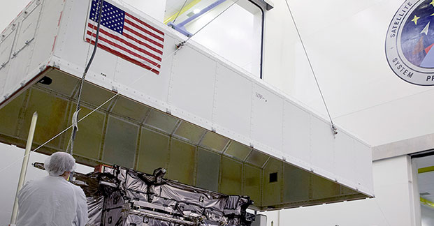
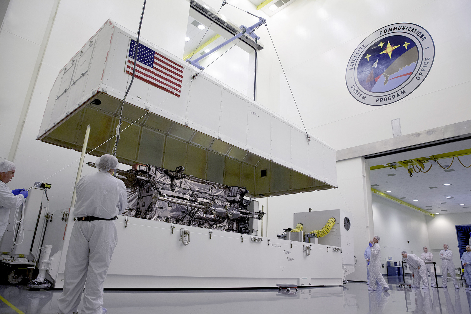
The GNST arrives at Cape Canaveral Air Force Station, Florida, in July.
The Lockheed Martin prototype of the next-generation GPS satellite, the GPS III, has proven that it is backwardly compatible with the existing GPS satellite constellation in orbit.
During tests that concluded on October 17, Lockheed Martin’s GPS III testbed successfully communicated via cross-links to Air Force simulators of the current GPS constellation in orbit. The current GPS constellation includes GPS IIR, GPS IIR-M, and GPS IIF satellites.
Testing also demonstrated the ability of an Air Force receiver to track navigation signals transmitted by the GPS III Nonflight Satellite Testbed (GNST). The GNST is a full-sized, functional satellite prototype at Cape Canaveral Air Force Station.
“These tests represent the first time when the GNST’s flight-like hardware has communicated with flight-like hardware from the rest of the GPS constellation and with a navigation receiver,” explained Paul Miller, Lockheed Martin’s director for GPS III Development. “This provides early confidence in the GPS III’s design to bring advanced capabilities to our nation, while also being backward-compatible.”
Lockheed Martin is under contract to produce the first four GPS III satellites (SV 01-04), and has received advanced procurement funding for long-lead components for the fifth, sixth, seventh, and eighth satellites (SV 05-08). The first flight-ready GPS III satellite is expected to arrive at Cape Canaveral in 2014, for launch by the Air Force in 2015.
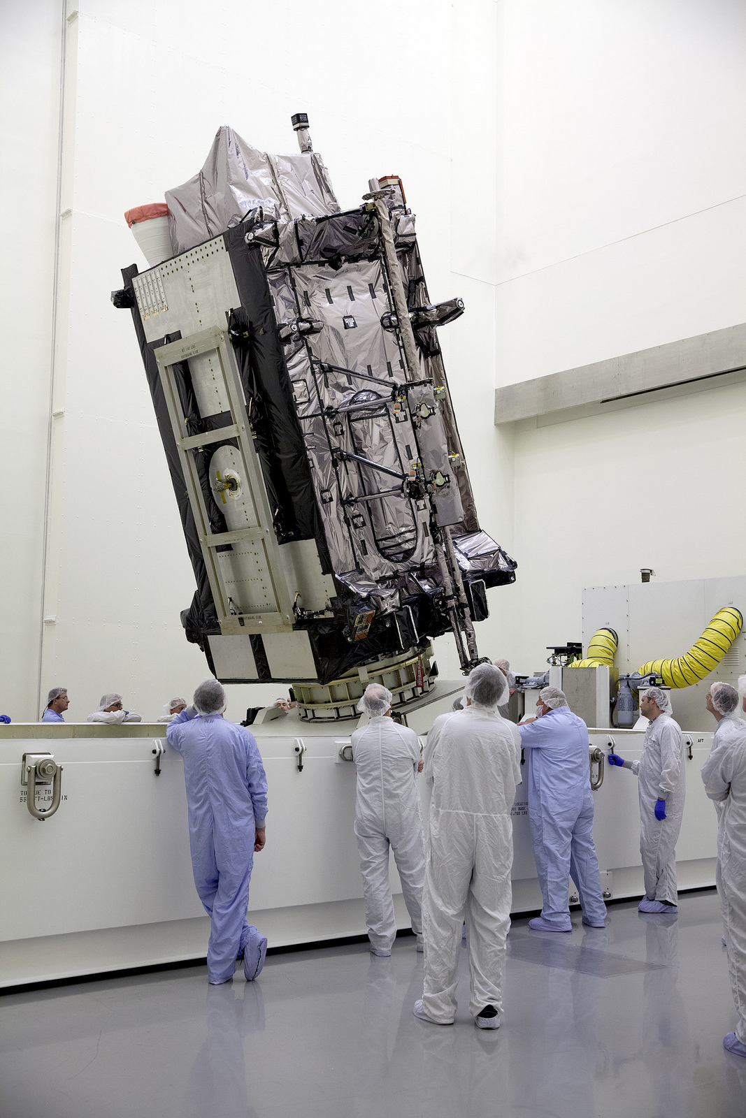
Testing took place with the GNST — a test version of the GPS III — at Cape Canaveral.
GPS III, a critically important program for the Air Force, will replace aging GPS satellites in orbit while improving capability to meet the evolving demands of military, commercial and civilian users. GPS III satellites will deliver three times better accuracy; provide up to eight times more powerful anti-jamming capabilities; and include enhancements to extend spacecraft life 25 percent further than the prior GPS block. It will be the first GPS satellite with a new L1C civil signal designed to make it interoperable with other international global navigation satellite systems.
An innovative investment by the Air Force under the original GPS III development contract, the GNST has helped to identify and resolve development issues prior to integration and test of the first GPS III flight space vehicle (SV 01). Following the Air Force’s rigorous “back-to-basics” acquisition approach, the GNST has gone through the development, test, and production process for the GPS III program first, significantly reducing risk for the flight vehicles, improving production predictability, increasing mission assurance, and lowering overall program costs.
The GNST arrived at the Cape on July 19 to test facilities and pre-launch processes in advance of the arrival of the first flight satellite. On August 30, the GNST successfully established remote connectivity and communicated with the GPS Next Generation Operational Control System (OCX), being developed by Raytheon.
Before shipment to the Cape, the GNST completed a series of high-fidelity activities to pathfind the integration, test and environmental checkout that all production GPS III satellites undergo at Lockheed Martin’s GPS III Processing Facility (GPF) in Denver, Colo.
The GPS III team is led by the Global Positioning Systems Directorate at the U.S. Air Force Space and Missile Systems Center. Lockheed Martin is the GPS III prime contractor, with teammates including ITT Exelis, General Dynamics, Infinity Systems Engineering, Honeywell, ATK, and other subcontractors. Air Force Space Command’s 2nd Space Operations Squadron, based at Schriever Air Force Base, Colo., manages and operates the GPS constellation for both civil and military users.
U.S. Air Force engineers are testing on-orbit a technique to extend the life of the 19 GPS IIR and IIR-M satellites on orbit, roughly 60 percent of the current constellation.
A new charging method may reduce the rate of satellite battery degradation, thereby extending satellite operational life. If the technique passes the test, the initiative could add a combined 20 years to the life of the satellites — saving the Air Force tens of millions of dollars in the process.
Gen. William Shelton, commander of Air Force Space Command, credits Capt. Jacob Hempen of the Air Force’s 2nd Space Operations Squadron for the job. Capt. Hempen says in turn that Warren Hwang of the Aerospace Corporation originated the idea.
When satellite solar panels are directly exposed to the Sun, they charge satellite batteries while continuing to power other operations on board the space vehicle. When the satellite passes into the Sun’s shadow behind the Earth, it runs on batteries. The batteries can be recharged at variable rates. When some of the batteries are powered above a certain rate threshold, they can overheat, accelerating their natural rate of decay.
Lowering battery charging rates could still enable the satellites to perform well while minimizing the rate of degradation. Hitting the optimum number called for some finely-honed calculations.
The satellites were built by Lockheed Martin Space Systems, and the oldest still in operation was launched in 1997. They had an initial design life of eight years, which many have now well outlasted. If the technique proves out and is carefully applied across the board, it could conceivably fill in replenishment gaps equivalent more than two additional spacecraft — conceivably as much hundreds of millions of dollars in build and launch costs, postponed. In today’s budget environment, a postponement can be construed as equivalent to outright savings.
The U.S. Air Force has awarded Lockheed Martin a $6 million contract to develop and demonstrate a payload that will temporarily transmit a third civil signal, on the L5 frequency at 1176MHz, from a Block IIR-M satellite.
Previous plans called for the L5 civil signal, aimed principally at safety requirements in civil aviation, to appear on the Block IIF satellites. Early speculation posits that the Air Force may want to conduct some signal testing before the IIFs are launched, or secure the frequency according to ITU requirements, as GIOVE-A did for Galileo.
Lockheed Martin and its navigation payload supplier ITT will provide an in-orbit demonstration of the new civil signal.