Tag: GPS Insights

  • UAVs doing the dirty work in war and nuclear inspections

    UAVs doing the dirty work in war and nuclear inspections

    Now that balloon-season appears to be ending, unmanned aerial vehicles (UAV) are seeing more use in the war in Ukraine. With the delivery of an updated fast transport craft to the U.S. Navy, autonomous ship operations are expected to be tested extensively. In addition, use of collision-protected UAV is demonstrating high returns for nuclear facility inspections.

    UAVs used in Russia-Ukraine war

    UAV attacks on Moscow seem to be escalating. A Ukrainian UJ-22 UAV allegedly crashed March 2 near the village of Gubastovo, about 60 miles from Moscow. It’s not clear what the intended target was, or whether the UAV was armed, but an undamaged Gazprom gas plant is close to where the UAV crashed.

    The UJ-22 UAV has a maximum range of about 500 miles. Therefore, to maximize its range, it’s unlikely that a big payload was onboard. It may have been just an attempt to assess how far the UAV could penetrate Russian airspace and which targets are in range from Ukraine’s border.

    In an earlier apparent UAV attack, the Krasnodar oil facility about 500 miles from the Ukraine border was damaged. A group of Belarusian partisans announced that it attacked and damaged a Beriev A-50 Airborne Warning and Control aircraft (called Mainstay by NATO) using UAVs at the Machulishchy airfield near Minsk, escaping back into Belarus without incident.

    The peaceful use of UAVs for the good of humanity seems to be taking a backseat in the escalating Russian-Ukraine conflict, where armed UAVs are enabling previously unheard-of incursions. Russia will likely respond, hopefully limiting action to legitimate military targets as Ukraine has done. However, the existing Russian stock of Iranian-made Shahed 136 “loitering munition” and the Mohajer-6 reconnaissance UAV might be running low. Ukraine has shot down at least 24 Shahed 136 UAVs through January and February and Russia has recently reduced its UAV attacks on Ukraine.

    US Navy relies on autonomous capabilities

    The U.S. Navy is making great strides in its efforts to incorporate ships with autonomous capability into its fleet. Several developments initiated in 2008 have led to the creation of a fleet of 12 Spearhead EPF Expeditionary Fast Transport ships built by Austal USA. The latest ship, the USNS Apalachicola EPF-13, has been outfitted during build with complete autonomy and has just joined the fleet. The EPF fleet is designed for the rapid deployment of troops, tanks/armaments and heavy equipment. The latest EPF-13 — built by Austal USA, L3Harris and General Dynamics Mission Systems — has a range of 1,200 miles, can accommodate the V-22 Osprey tilt-rotor aircraft, and clocks in at a maximum speed of 40 knots.

    Image: Austal USA
    Image: Austal USA

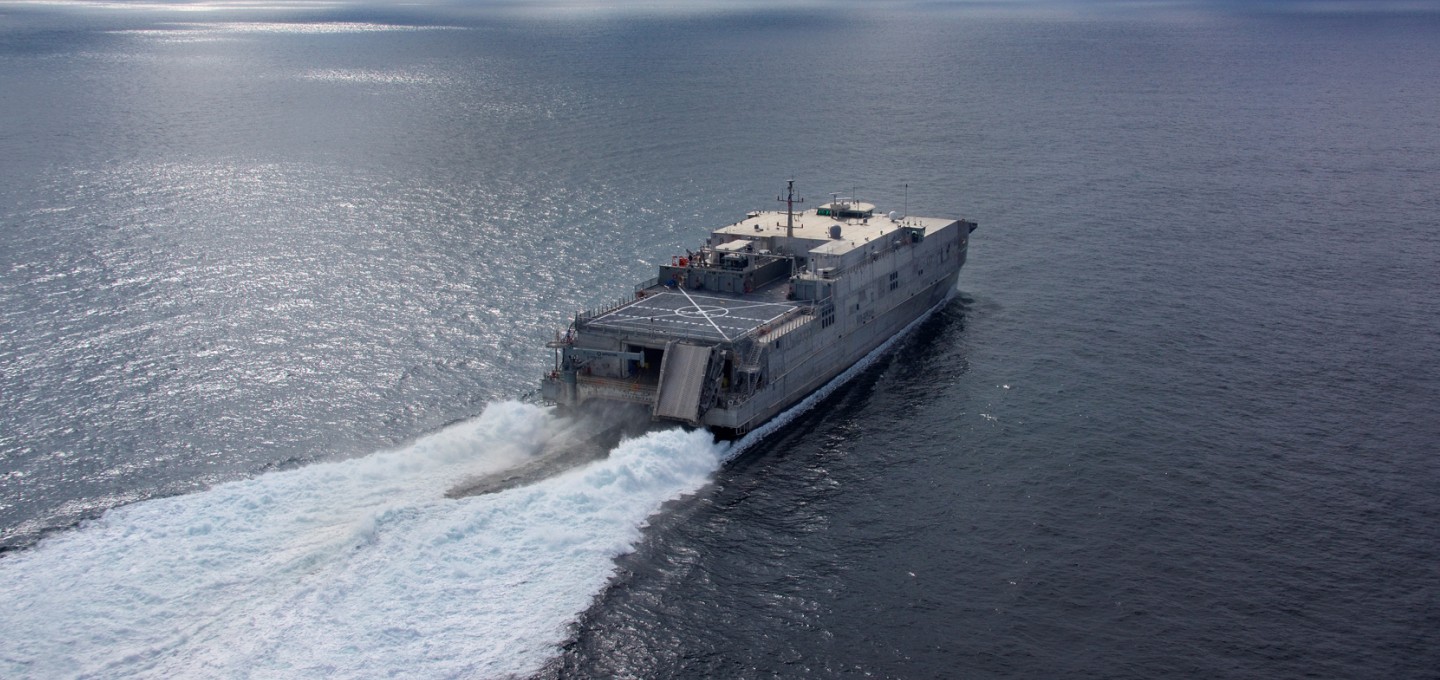
    The earlier ships incorporated automation of hull, electrical and mechanical/power systems, which are all now accessible on the bridge. The latest EPF-13 has added automated maintenance, health monitoring and mission readiness. The EPF 13 Apalachicola comes with the ability to run independent unmannered operations for up to 30 days. At 337 feet long and displacing 362 tons, the EPF can carry up to 600 tons of weapons and equipment, while running a draft of less than 15 ft. Alternatively, EPFs have sufficient capacity to transport 312 soldiers over short distances, plus a crew of 41 when fully manned.

    Inspecting nuclear facilities with UAVs

    Clean-up operations at nuclear waste facilities are continuing to use UAVs for inspection and assessment of locations that are difficult to access and potentially contaminated. Flyability intends to add a Miron RDS-32 radiation sensor to its Elios-3 UAV family to gather in-situ radiation measurements while inspecting complex confined spaces at nuclear sites.

    In recent activity at a nuclear plant, an annual inspection of three tank rooms and collection of detailed visual video of a suspected leaking valve were readily accomplished in two UAV inspection sessions of a few minutes each.

    The previous manual inspection process required the plant output to be reduced to 20% of normal capacity over a six-hour cooldown. When radiation levels became low enough, two inspectors dressed in protective gear climbed down into the first tank room where radiation levels exposed each person to around 250 millirem (2,500 µSv or about 10% of the allowed annual exposure). They took a few still pictures and measured radiation levels, then exited each hot area before repeating the process for the other two tank rooms. The whole time, the productive output of the plant was significantly reduced. Another six hours was required afterwards to restore the plant back to full output, never mind that personnel were exposed to a bunch of radiation.

    Flyability’s solution is to fly an Elios UAV down into each tank room, take high-resolution video of the entire area in 1-2 minutes and repeat the process for each of the other tank rooms, without reducing plant output power. For detailed inspection of the suspected valve, the UAV was flown deeper into the reaction vessel. Detailed video was collected and the UAV was extracted — all within about 10 minutes.

    The bottom line is that generation of around 4.8 GW of power, worth maybe $456,000, was saved using the Elios UAV inspection approach. No one was exposed to the higher radiation levels inside the facility, and significant time was saved for both the annual and suspected valve inspections. Incidentally, the valve in questions was cleared of any potential leaks.

    Conclusion

    In summary, developments in autonomy include use in the Ukraine-Russian war, more ship automation for the U.S. Navy, and more efficient inspection of nuclear facilities.

  • GPS Insights – April 2007

    Ubiquity and the Joint Navigation Conference

    OK, there I was, straight and level at 6,000 feet, when . . . .

    Now, fellow aviators among you will recognize this as the classic opening line at the bar when aviators talk with their hands, shoot their watch, and probably tell a tall tale while they are at it. But seriously, folks, there I was at 6,000 feet, which in the Rocky Mountains simply means I was headed North toward the Denver airport at o-dark-thirty on a snowy morning.

    I was enroute to the Joint Navigation Conference in Orlando and was naturally thinking about my next column. My newest GPS appliance shone brightly against a dark windscreen, the snow flew, and my favorite national public radio station played softly in the background.

    As I thought about how tp address the phrase “GPS has become a utility” in my column, I heard a report about British special operations hostages held in Iran for supposedly being in the wrong place at the wrong time. Hoping to hear they had been released, I turned up the volume just in time to hear a female interviewer ask the on-scene reporter something like, “Isn’t there some satellite thingy that will tell us where the British soldiers really were? I mean, you know, something in space that tells us where we are. Didn’t they have something like that?”

    No doubt she was talking about GPS, and while that’s heartening, my point here is she did not know what it was. GPS has become such a ubiquitous global utility in our daily lives that some don’t know any more about it other than that it is some satellite ‘thingy’ in space.

    That’s fine as far as it goes, but it points out a vulnerability of our current system. If you were to ask the American public or any global “public” to vote on whether to continue to fund and support the United States GPS, would they even know what it was? I am not denigrating reporters or the American public here, but just making the point that “the satellite thingy in space” is a ubiquitous global utility that we take for granted, and would find it inconvenient at best, and crippling at worst, to live without.

    Think I am overstating my case? Think again. I recently had the pleasure to participate in a very high-level think-tank study that determined, among other things, that if GPS were to fail today, there is an excellent chance that credit cards would not function, gas pumps would not operate, cell phones would not work, internet, bank and stock transactions would slow to a crawl, and on and on.

    To fully understand this, remember that the Global Positioning System is also known as a PNT or Positioning, Navigation and Timing system. The position and navigation part is what we generally think of, but in reality more than 90 percent of the users of GPS worldwide use it primarily for a timing reference. GPS is based on atomic clocks in space, and the timing signal is classified as a Stratum 1 signal, which means it is accurate and stable to 1×10-11 or better.

    At this minimum accuracy, a properly calibrated source will provide bit-stream timing that will not change relative to an absolute or perfect standard more than once every five months. Atomic standards such as Cesium clocks, which are used in GPS satellites, have far better performance. I won’t belabor this point now because I plan a series of articles considering the importance of GPS time at a later date. Suffice it to say this is a very accurate timing signal and is the heart of the GPS infrastructure.

    This timing discussion provides a nice segue to the topic of LORAN and eLORAN, which last month I listed as a key augmentation for the perfect handheld GPS transceiver. Several of you asked why and there are a myriad of reasons including: LORAN is a mature and proven system with much greater signal strength (you can use it indoors), but for our purposes here, know that it is also classified as a Stratum 1 timing signal, and for North America and certain other parts of the world it can and does currently serve as a GPS time reference augmentation/back-up system.

    JNC Briefing on Jamming Incident

    Why do we need a backup? Here is a classic case in point.

    At the JNC in Orlando, we heard from U.S. Coast Guard Captain Matthew Blizard, the commander of the USCG Center of Excellence for Navigation (NAVCEN), including GPS. Captain Blizard detailed a case study that should be a wake-up call for all GPS users and help point out the criticality of augmentations and back-ups for our ubiquitous global utility that we all too often take for granted (GPS World editor-in-chief Alan Cameron briefly mentioned this incident in the March issue).

    The quick version of the incident, which is full of irony, goes something like this. The U.S. Navy was conducting a scheduled communications jamming training exercise in the Port of San Diego. Two Navy ships participated in the exercise for approximately two hours. Although it involved communications jamming, GPS agencies such as the GPS Operations Center at Schriever AFB, Colorado (GPSOC) and the USCG NAVCEN were not notified because the intended jamming was not planned in the GPS L-band regime. But jam GPS they did — unintentionally of course — and the jamming continued for approximately two hours.

    When the technicians involved could not get their GPS on the second ship (the one being jammed) to initialize, they began to suspect there might be a problem. They suspected ‘they’ were the problem and were inadvertently jamming GPS. They immediately returned to the first ship and shut down the jammer.

    However, once the jamming began, it was less than 30 minutes before NAVCEN and the GPSOC and other organizations started receiving calls concerning GPS outages in the San Diego harbor area. The outages affected telephone switches and cellular phone operations and even shut down a hospital’s mobile paging system. General aviation GPS navigation equipment outages were reported, but no commercial airlines were affected, or at least none officially reported any outages. Reports continued to flow in for more than four hours.

    The Navy technicians shut down the unintentional jamming signal, but did not report the incident outside of normal channels. Consequently, it took NAVCEN and supporting agencies 72 hours to pinpoint the jamming source.

    The irony here is that the SPAWAR Systems Center for the GPS JPO (now GPS Wing) NAVWAR effort is located in San Diego and they routinely run jamming scenarios, simulations, and engage in modeling exactly what happened that day in the San Diego harbor — but reports indicate they were unaware of this incident until after it had occurred.

    Captain Blizard accepts that 72 hours to locate a jamming source, intentional or otherwise, is entirely too long. He and his NAVCEN team are working with the GPSOC, the Joint Space Operations Center (JSPOC) at Vandenberg AFB in California, and other agencies to put procedures in place to effectively shrink the timeline to find the source of the jamming to 20 minutes or less. All these players want to ensure that in the future, these incidents are so short-lived that users will not even notice them before they are resolved.

    There are lots of lessons learned here, and too many to go into in the space remaining, but this incident clearly emphasizes the vulnerability of our extremely low-power GPS signal to jamming and unintentional interference. It is also clear that we are not yet equipped nor have sufficient procedures in place to pinpoint jamming in a timely manner and take actions to negate it. However, it inspires confidence when you hear Captain Blizzard relate the incident, because you know he is working the solution hard. There was no attempted cover-up, it is all out in the open, warts, ironies and all, and it is clear that the solution is getting plenty of attention.

    The Perfect Military Receiver

    In light of the above incident, where does this leave us with our Perfect Handheld GPS Transceiver? Would it have been affected, or would it have continued to perform normally?

    Although I have not mentioned anti-jam capabilities specifically, using that nomenclature, almost all the features we have mentioned so far (see last month’s newsletter for the list) would have had an effect on the jamming problem.

    Since it receives all the GPS frequencies, those not affected by the jamming would have continued to perform — M-code for example — plus GLONASS would have still been received, along with any out-of-band pseudolite signals and hopefully several augmentations. The point is that almost any additional features that boost the power of the signal, receive additional signals, and monitor jamming or interference, would have made our transceiver impervious to the incident in question. They are all anti-jam modalities in one form or another. Of course, a stronger GPS signal in the first place might have made the entire scenario moot, but that is a discussion for another time.

    What shall we add to our Perfect Handheld GPS Transceiver this time to make it more complete? Several of you wrote to say that anti-jam features should be at the top of my list, and hopefully I have explained that they indeed already are, but they are not just anti-jam features, they are much more than that, when you consider them in the correct venue.

    So this time, let’s add the following technologies and features to our Perfect Handheld GPS Transceiver (PHGPST):

    • micro-electromechanical systems (MEMS) technology or nanotechnology
    • An embedded atomic clock or Stratum-1 time source
    • Gigabytes of storage
    • Fast processor

    By the time you read this column, I will have attended the ESRI Partners-only Conference in Palm Springs, California, the Joint Navigation Conference in Orlando, Florida, and the 23rd Annual National Space Symposium in Colorado. All three events contained enough new and vital information about GPS, GIS, and GNSS to keep me busy writing columns for months. The hard part is to filter out what you want and need to hear now as a government or military user.

    Thanks to everyone who took time to stop by the booth to say hello, and especially thank you to those who signed up for new subscriptions.

    I also want to thank everyone who responded so positively to my first column. The mail was very encouraging and helpful. Lots of new sources for me to pursue. I promise to answer all my mail, positive or not, as quickly as I can. Just be patient, there were many of letters and emails. My editor tells me we set some kind of record for response to new publications. Certainly for response to new e-publications.

    I’ll see you right here next month.