Tag: GPS mapping

  • Seen & Heard: GM sued over data collection; archaeologists uncover hidden empire and more

    Seen & Heard: GM sued over data collection; archaeologists uncover hidden empire and more

    “Seen & Heard” is a monthly feature of GPS World magazine, traveling the world to capture interesting and unusual news stories involving the GNSS/PNT industry.


    Texas Sues GM for Allegedly Selling Drivers’ Data

    Photo: baona / iStock / Getty Images Plus / Getty Images
    Photo: baona / iStock / Getty Images Plus / Getty Images

    The Texas Attorney General’s Office has filed a lawsuit against General Motors (GM), alleging that the company unlawfully collected and sold driving data from more than 1.5 million Texas drivers. The lawsuit claims that GM gathered detailed information from vehicles manufactured since 2015. Additionally, the lawsuit alleges that GM deceived customers by compelling them to enroll in data collection services during the vehicle “onboarding” process, without fully disclosing how their information would be used. The collected data was reportedly used by third-party companies to generate “driving scores” which were then sold to insurance providers.

    3D Scans Reveal Medieval Secrets

    Photo: Stichting Grote Kerk Naarden
    Photo: Stichting Grote Kerk Naarden

    The Grote Kerk in Naarden, Netherlands, known as the “Sistine Chapel of the North,” is undergoing a 3D scanning project to uncover the secrets of its medieval ceiling murals. A team of researchers from various Dutch universities are collaborating to create a detailed digital 3D model of the church’s barrel vault, covering 700 square meters of painted planks and beams. The project aims to shed light on long-standing mysteries surrounding the artwork’s origins, including the identities of the artists and the precise timeframe of their creation. Researchers will use advanced 3D scanning technology to produce high-resolution digital replicas of the murals, allowing researchers to examine the artwork in extraordinary detail.

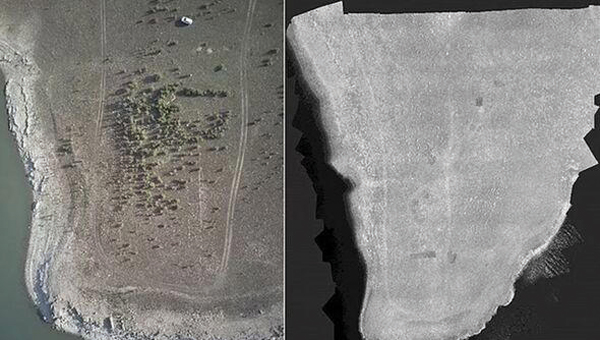
    Archaeologists Unearth Hidden Empire

    Photo: University of Cádiz
    Photo: University of Cádiz

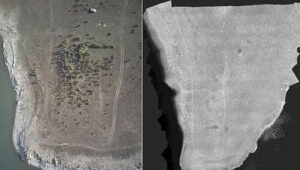
    Archaeologists from the University of Cádiz in Spain have discovered 57 Roman Empire-era sites in the Sierra de Cádiz regions, revealed what researchers believe to be an undiscovered part of the Roman empire. The team used multispectral cameras and lidar to detect these hidden sites. The team has begun on-site excavations, including work at the Roman villa of El Canuelo in Bornos, and plans to continue its research to gain a more comprehensive view of Roman settlement in the region.

    Mapping Secrets of the Seafloor

    Photo: SuBastian/Schmidt Ocean Institute via CNN
    Photo: SuBastian/Schmidt Ocean Institute via CNN

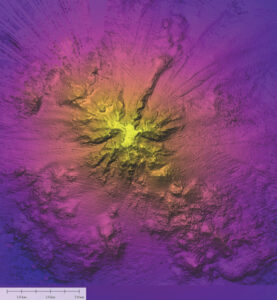
    Oceanographers from the Schmidt Ocean Institute used advanced sonar technology to map a massive underwater mountain in Nazca Ridge, 900 miles off the coast of Chile. The team employed a hull-mounted sonar system on their research vessel, R/V Falkor, to create detailed maps of the seafloor. In addition to sonar mapping, the team used an underwater robot to explore the mountain and surrounding areas. This robotic technology allowed them to document rare marine life, including the ghostly white Casper octopus and unusual siphonophores nicknamed “flying spaghetti monsters”.

  • New speaker, technologies on July 28 GIS field data collection webinar

    Date: Thursday, July 28, 2016LaserTechnologyLogo-WebinarEmail
    Time: 1 p.m. EDT / 10 a.m. PDT
    Sponsor: Laser Technology

    A new speaker and a new mapping technology have joined the line-up for next Thursday’s (July 28) free webinar, “Laser Rangefinders, Lidar, Cameras and More:  Other Sensors Integrated with GNSS for Special Mapping Requirements.” Survey and mapping consultant Eric Gakstatter will speak on the use of digital cameras, laser rangefinders, and lidar.

    Eric Gakstatter
    Eric Gakstatter
    He joins Joakim Rydell, author of the magazine’s July cover story, “See Into the Smoke with Inertial,” and Paul Adkins, global communications manager for Laser Tech, Inc. Overall, the panelists will present valuable business and technical information to increase  workflow efficiency with smart devices, apps, rangefinders and cameras, and to keep attendees on the forefront of new GIS field data collection methods.

    Field data collection and mapping is booming in many industrial, business, defense and other organizational workflows. The demand for accuracy and data richness constantly increases, and the frontiers for mapping and navigation are steadily pushing outward through all types of obstructed environments — or inward. These new positioning challenges are met by a range of sensors complementing GNSS: laser range-finders, inertial measurement units, cameras of various kinds and more.

    Practitioners and researchers in these industries will find this GPS World webinar material profitable:

    • Survey and Defense
    • Mining and Construction
    • GIS Mappping and GPS Mapping
    • Forestry and Natural Resource Management
    • Utilities and Telecommunications

    Speakers:

    JoakimRydell

    Joakim Rydell
    Senior Scientist, Swedish Defense Research Agency

    “Inertial Navigation and Dense Distance Measurements from a Range Camera”

    A prototype for soldiers and first responders in dangerous environments integrates inertial navigation with near-infrared images and dense distance measurements from a range camera using active illumination. This produces real-time results on a tablet computer. Experiments demonstrate that the system provides good positioning and mapping performance in a range of indoor environments, including darkness and smoke.

    PaulAdkins_2

    Paul Adkins
    Global Marketing Communications Manager, Laser Technology, Inc.

    “GIS Field Data Collection Using Smart Devices “

    Learn how to increase GIS field data collection workflow efficiency utilizing smart devices (BYOD), internal GPS and apps with compact total station laser rangefinders. Also, using the camera function on the smart devices and/or laser.

    Eric Gakstatter
    Contributing Editor, GPS World, Geospatial Solutions

    Gakstatter is a contributing editor for the Geospatial Solutions Monthly e-newsletter, an e-newsletter focused on geospatial technologies. He owns and operates his own drone or UAV. Following 10 years of work experience within the GPS/GNSS industry, since 2000, he’s been a power user of GPS/GNSS technology as well as a consultant with capital management companies; federal, state and local government agencies; and private companies on the application and/or development of GPS technology. Since 2006, he’s been a contributing editor to GPS World magazine and the Geospatial Solutions website.

    Moderator:

    Alan Cameron
    Editor-In-Chief, GPS World

    Cameron is editor-in-chief and publisher of GPS World magazine, where he has worked since 2000. He also writes the monthly GNSS System Design e-newsletter and the Wide Awake blog.


    Button

  • How to Use GPS to Make a Valentine

    How to Use GPS to Make a Valentine

    Yes, there is a way. According to Krulwich Wonders, an NPR science blog, a man in San Francisco equipped with an iPhone and tracking app rode his bike 27 miles around the city. Two and a half hours later, Payam Rajabi had etched a heart shape onto a city map.

    large-heart-map
    Click to enlarge.

    In 2012, Rajabi had to leave his girlfriend behind in Toronto for a new job. To make sure Clare knew this was a labor of love, Payam included an elevation map of his ups and down in the hilly city.

    This year, Verizon is featuring Rajabi — who repeated the feat for cameras — in a television commercial: