Tag: GPS module

  • Inexpensive sensor created to monitor Rhine river levels

    Inexpensive sensor created to monitor Rhine river levels

    A team of researchers has developed a low-cost sensor that can detect the changes in river height to provide wide-area flood warnings.

    The Raspberry Pi Reflector (RPR) was designed by a team of scientists from the University of Bonn, the Federal University of Rio Grande do Sul, and the University of Colorado.

    The solar-powered RPR is much less expensive (about US$150) than scientific-grade or geodetic GNSS instruments — the cost of which is “a limiting factor for their prompt and more widespread deployment as a dedicated environmental sensor,” the team writes in their paper.

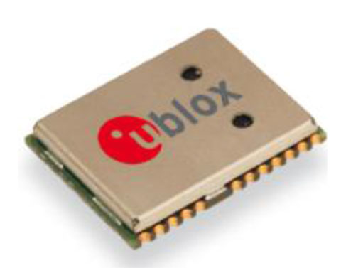
    The Raspberry Pi Reflector (RPR) prototype includes a low-cost and low-maintenance single-frequency GPS module (an Adafruit GPS FeatherWing receiver) and an unspecified GPS antenna connected to an inexpensive Raspberry Pi microcomputer. One such unit has been successfully operating since March 2020 in Wesel, Germany, next to the Rhine river.

    Photo:
    The RPR hardware array: (a) Raspberry Pi 4 Model B (b) Adafruit Feather Adalogger microcontroller (c) Adafruit GPS FeatherWing receiver (d) GPS external antenna (e) Configuration of RPR prototype setup. (Image: Karegar, et al)

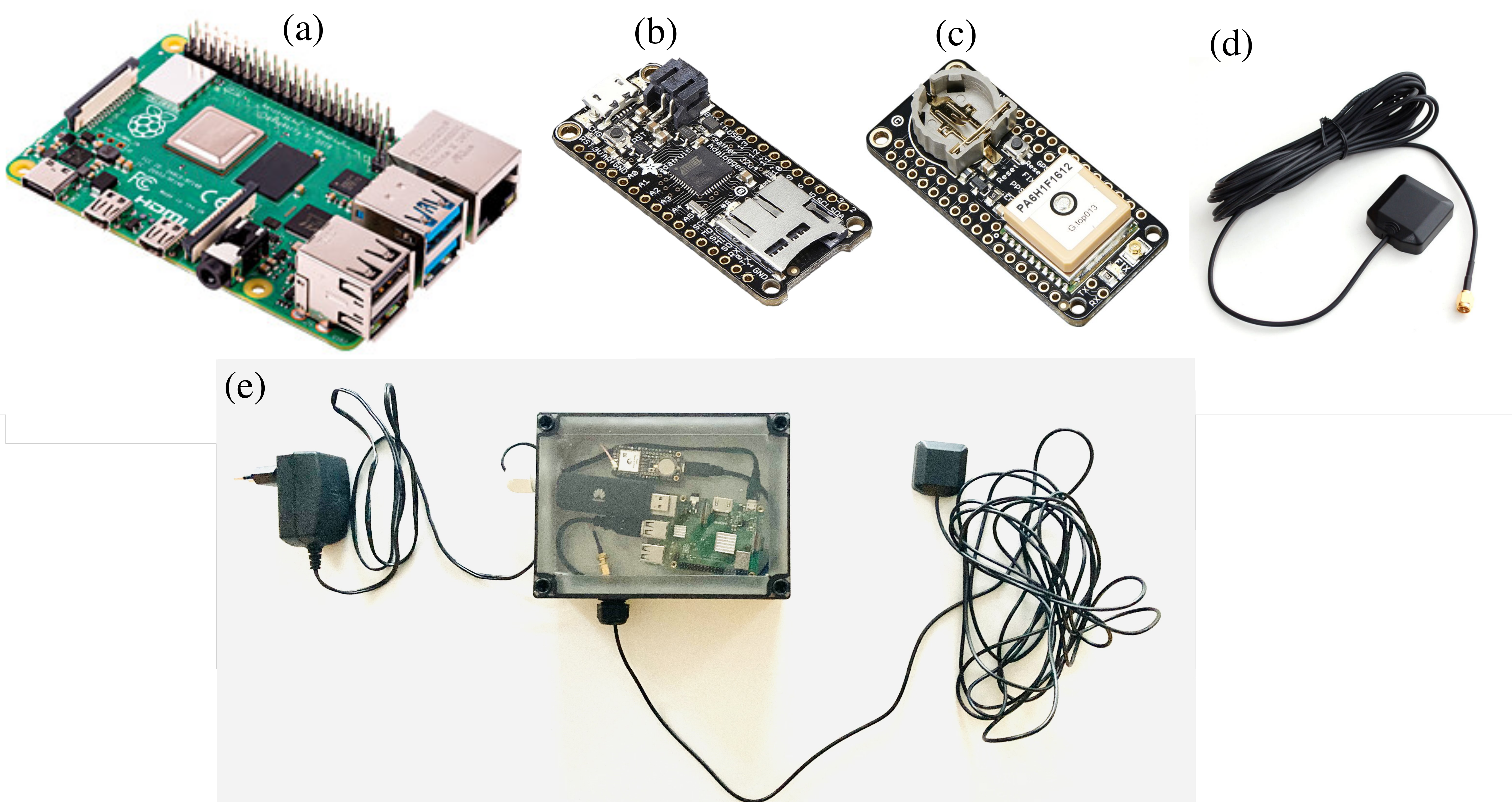
    The unit on the Rhine provides sub-daily and daily water levels retrieved using spectral analysis of reflection data, or GNSS-reflectometry. The river level measurements from the RPR are compared with a co-located river gauge.

    By changing the orientation of the antenna from upright to sideways facing the river, which was done in August 2021, the root-mean-square error (RMSE) was lowered to from 7.6 cm to 3 cm (sub-daily) and 6 cm to 1.5 cm (daily), the team said.

    “While satellite radar altimetry techniques have been utilized to monitor water levels with global coverage, their measurements are associated with moderate uncertainties and temporal resolution,” the team states. “Therefore, such low-cost and high-precision instruments can be paired with satellite data for calibrating, validating and modeling purposes.”

    Information about the RPR is available on GitHub.

  • YIC offers low-power GPS/GNSS module for internet of things

    YIC offers low-power GPS/GNSS module for internet of things

    YIC logoYuechung International Corp. (YIC) is offering a GPS/GNSS module for internet of things (IoT) applications.

    YIC is a manufacturing and design company for quartz crystals, crystal oscillators, GPS/GNSS modules, GPS/GNSS receivers and RF antennas. It provides low-power solutions to solve product problems that require frequent charging.

    YIC’s new product — the Ultra Low Power GPS/GNSS Module (Model YIC71009EBGG and YIC71513PGMGG) — is designed as an IoT product solution, targeted to improve the operating times of IoT applications such as trackers, wearables and portable devices.

    According to its press release, YIC “is dedicated to providing the best solution for GPS devices and sees a tremendous opportunity in the GNSS market to solve power consumption problems.” The recent industry trend of multi-frequency GPS, low-power consumption, and dead reckoning will be advantageous to YIC in terms of high-grade products entering the global market.

    Models YIC71009EBGG and YIC71513PGMGG provide:

    • Ultra-low power consumption – 6mA (Typical).
    • Multi-constellation – GPS/QZSS + GLONASS.
    • Small size

    About YIC

    Founded in 1994 and headquartered in New Taipei City, Taiwan, YIC is a professional partner in frequency control, GPS/GNSS modules, receivers and RF antennas, advanced low power GPS, and small size solutions.

  • First development kits available for Septentrio’s mosaic GNSS module

    First development kits available for Septentrio’s mosaic GNSS module

    Septentrio’s Mosaic chip-level GNSS. (Photo: Septentrio)
    Septentrio’s mosaic chip-level GNSS. (Photo: Septentrio)

    Septentrio’s mosaic development kit is now available for testing and integration.

    Mosaic is Septentrio’s most compact, next-generation, high-precision multi-frequency GPS/GNSS module. The receiver brings precision and reliability of high-end multi-frequency GNSS to mass-market applications, the company said. It is designed to fit into the assembly-line process, which allows mosaic to be favorably priced for high volumes.

    Its lightweight and low power consumption helps extend the battery life of robotic devices, increasing operation time and efficiency. This makes mosaic suitable for applications such as robotics, automation, telematics and wearables.

    “We see a growing demand for reliable high-precision positioning,” said Chris Lowet, product manager at Septentrio. “A few years ago, this demand was concentrated in professional applications, for example survey, high-precision mapping and machine control. Today, with expansion of robotics, automation and IoT, a wide range of devices need high-precision positioning, from ag robots to IoT gateways to autonomous vehicles. We designed mosaic to answer these market needs.”

    Highlights of mosaic include:

    • Centimeter positioning in tough environments with multi-frequency, multi-constellation GNSS technology
    • Advanced Interference Mitigation (AIM+), which allows users to continue working despite radio interference from other electronic devices or jamming
    • Extensive corrections support for high-accuracy positioning: SBAS, PPP, SSR, RTK
    • RAIM+, integrity engine needed for safety-critical applications such as autonomous vehicles
    • Tracking all current and future GNSS satellite signals for enhanced real-time kinematic (RTK) performance and guaranteed RTK network compatibility
    • 100-Hz update rate, suitable for robotics and fast-moving vehicles.

    The development kit assists Septentrio customers with integrating mosaic into their system. It supports connectivity through internet, COM ports, USB 2.0 as well as an SD Card slot. The development kit can be requested here.

  • VersaLogic offers high-precision GPS in Mini PCIe format

    VersaLogic has released an industrial temperature GPS module that provides access to multiple satellite systems. It offers higher accuracy than previous models, for both location and timing data, the company said.

    Its multi-channel capability also allows better accuracy and coverage in difficult environments such as cityscape and building canyons.

    “The need for enhanced accuracy and precision timing data is growing in embedded computing. The G3 has time pulse accuracy that is less than 20ns when outdoors and 0.5 seconds indoors,” said Kerry Howell, VersaLogic product manager. “When combined with its ability to use multiple satellite systems simultaneously, the G3 becomes a very valuable positioning tool.”

    The advanced GPS receiver provides two simultaneous receiver paths with 72-channel operation for stable satellite tracking, as well as aided startup for fast initial signal acquisition. Increased coverage is provided by support for GPS, GLONASS, Galileo and BeiDou systems.

    In addition to positioning and navigation applications, GPS/GNSS signals are widely used as precision time or frequency references for remote or distributed wireless communication, industrial, financial and power-distribution equipment.

    The G3’s extremely small Mini PCIe format allows it to be added to a system with little impact to the overall size of the system. The G3 is compatible with a variety of popular x86 operating systems including Windows, Windows Embedded and Linux using standard software drivers.

    The G3 is designed and tested for industrial temperature (-40 degrees to +85 degrees Celsius) operation and meets MIL-STD-202G specifications to withstand high impact and vibration. It is RoHS compliant, and includes VersaLogic’s 5+ year production life guarantee.

    It is customizable, even in low OEM quantities. Customization options include conformal coating, revision locks, custom labeling, customized testing and screening and more.


  • VectorNav granted AS9100 aerospace accreditation

    VectorNav granted AS9100 aerospace accreditation

    VectorNav’s new Tactical Series includes the VN-110 IMU/AHRS, the VN-210 GPS/INS and the VN-310 dual-antenna GPS/INS.

    VectorNav Technologies, a provider of inertial navigation solutions, has received accreditation for the AS9100 Rev. D international aerospace standard for its Dallas headquarters.

    Based on ISO 9001 standards, the AS9100 standard is a set of quality requirements established by the aerospace industry to satisfy DOD, NASA and Federal Aviation Administration quality requirements.

    Founded in 2008, VectorNav is an innovator of miniature, high-performance micro-electro-mechanical systems and GPS/GNSS-based inertial navigation systems.

    Recent releases include VectorNav’s surface mount VN-100 IMU/AHRS, VN-200 GPS/INS and VN-300 dual-antenna GNSS/INS, in a new tactical-grade line of inertial navigation systems.

    The AS9100 accreditation marks VectorNav’s achievement in demonstrating the highest level of manufacturing, quality and customer service standards. The certification represents the company’s ability and commitment to deliver to its customers worldwide the highest quality miniature inertial navigation systems, from rapid procurement during testing and development to high-volume capacity for integration and production, the company said.

    “Earning the AS9100 designation for our Dallas facility demonstrates that we are a highly capable supplier to the global aerospace industry,” said Scott MacDonald, process and quality engineer at VectorNav. “Operating to the highest standards of quality has always been a core principle for us, and this certification reflects our continued commitment to ensure our processes and systems deliver products and services that exceed our customers’ quality, cost, and speed expectations.”

  • Swift Navigation releases firmware 1.1 upgrade for Piksi Multi

    Swift Navigation releases firmware 1.1 upgrade for Piksi Multi

    The Piksi Multi. Photo: Swift

    Swift Navigation has released its first major firmware upgrade for its flagship product, the Piksi Multi GNSS module.

    The upgrade is available at no cost to Piksi Multi users and expands on dynamic real-time kinematic (RTK) application support, increasing functionality for users, expanding use-case applications and allowing users to better leverage existing infrastructure and facilitate post-processing.

    Firmware version 1.1 updates include:

    • Increased Data Output Rates to Support Dynamic Use Cases
    • GNSS Measurements (Raw Data) – Up to 20 Hz
    • RTK Output Support
    • Low Latency Mode – Up to 20 Hz
    • Time-Matched/Heading Mode – Up to 5 Hz
    • IMU (Raw Data) – Up to 200 Hz

    Moving Baseline RTK Support. The capability to do real-time, precise relative positioning between two receivers where both receivers can now be in motion.

    RTK-Based Heading Support. The capability to do real-time RTK-based heading for direction finding — even when stationary — without the need for expensive navigational equipment such as gyrocompasses.

    Improved 1 PPS Support. The Piksi Multi Pulse Per Second (PPS) feature has been upgraded to support more customization.

    Standalone RINEX Conversion Utility Tool. The tool allows end-users using RTKLIB, such as those with UAV surveying applications, additional tools to support their post-process kinematic needs.

    Improved Compatibility with Existing Infrastructure (RTCM 3.1 Input). This added support enables end-users to better leverage existing base station infrastructure to receive RTK corrections (observations, station coordinates, etc.) from already deployed Continuously Operating Reference Stations (CORS).

    For detailed information about the upgrades, refer to the Piksi Multi Firmware 1.1 Release. For detailed instructions on how to upgrade a Piksi Multi device, refer to Section 7 of the Getting Started Guide, Piksi Multi – Upgrading Firmware. For firmware release binaries and product support documentation, visit support.swiftnav.com.

  • Telit Introduces Jupiter GPS Module for Migration to Full GNSS

    Telit Introduces Jupiter GPS Module for Migration to Full GNSS

    The Jupiter SL871-S.
    The Jupiter SL871-S.

    Telit Wireless Solutions has debuted the Jupiter SL871-S, designed for easy migration between a full-GNSS solution for top-ranked applications and a simple GPS-only solution for less demanding applications. The Jupiter SL871-S is designed to track and navigate GPS and QZSS constellations while ensuring pin-to-pin and protocol compatibility with its multi-constellation companion module, the SL871.

    The module comes in a 9.7 x 10.1 millimeter LCC package with an ARM7 baseband processor, embedded ROM memory, and integrated LNA. It delivers geolocation data using NMEA protocol through a standard UART port. It supports ephemeris file injection (A-GPS) as well as Satellite Based Augmentation System (SBAS) for increased position accuracy.

    In addition, its extremely low power consumption in all conditions is suited to applications requiring long battery life.

    SL871-S has been designed to ensure hardware and software compatibility with SL871, allowing customers to design once and take advantage of the xL871 common form factor. Benefits include:

    • Pin-to-pin compatibility with SL871 family,
    • Same protocol used in SL871,
    • Straightforward migration between full-GNSS solutions and GPS-only solutions,
    • Satellite Based Augmentation System (SBAS) support for increased position accuracy, and
    • Assisted GPS.

    The SL871-S can replace the SL871, allowing customers to design once and interchangeably mount the appropriate solution depending on the required features.

    “The new SL871-S module designed to be easily swapped with other xL871 modules for enhanced simplicity and scalability,” said Taneli Tuurnala, CEO of Telit GNSS Solutions. “It is an ideal example of how buying a module from Telit enables our customers to avert the need to keep track of the latest chipset technology on their own. We keep them on top of the best available technology, pre-packaged in a module that is easy to replace as needed, without having to redesign their entire application to stay up to date.”

  • Telit Introduces Jupiter SL869-V2S GPS Module

    Telit Introduces Jupiter SL869-V2S GPS Module

    The Jupiter SL869-V2S GPS module. Photo: Telit Wireless Solutions
    The Jupiter SL869-V2S GPS module. Photo: Telit Wireless Solutions

    Telit Wireless Solutions, a global provider of high-quality machine-to-machine (M2M) modules and services, today debuted the Jupiter SL869-V2S GPS module, designed for easy migration between a full-GNSS solution for top-ranked applications and a simple GPS-only solution for less demanding applications.

    The Jupiter SL869 V2S supports GPS as well as QZSS constellations and is ROM based. Geo-location data is delivered using NMEA protocol through a standard UART port. It supports ephemeris file injection (A-GPS) as well as Satellite Based Augmentation System (SBAS) for increased position accuracy. Its onboard software engine is able to locally predict ephemeris three days in advance starting from ephemeris data broadcast by GNSS satellites, received by the module and stored in the host flash memory.

    Key benefits include:

    • Pin-to-pin compatibility with JN3/xL869 family
    • Same protocol used in SL869 V2
    • Straightforward migration between full-GNSS solutions and GPS-only solutions
    • SBAS support, for increased position accuracy
    • Assisted GPS

    The SL869 V2S can replace the JN3, SL869 or SL869 V2 — allowing customers to design once and interchangeably mount the appropriate solution depending on the required features. The xL869 is Telit’s GNSS unified form-factor family, which allows customers to select among different GNSS technologies and feature sets. Modules in this family are offered in a 16 x 12.2 mm, 24-pad, LCC package.

    “The new SL869 V2S module is designed to be easily swapped with other xL869 modules for enhanced simplicity and scalability,” said Taneli Tuurnala, CEO of Telit GNSS Solutions. “It is an ideal example of how buying a module from Telit enables our customers to avert the need to keep track of the latest chipset technology on their own. We keep them on top of the best available technology, pre-packaged in a module that is easy to replace as needed, without having to redesign their entire application to stay up to date.”


  • Linx Releases RM Series GPS Module for Economical Positioning

    Linx Releases RM Series GPS Module for Economical Positioning

    Photo: Linx Technologies Linx Technologies announces its launch of the high-performance, low-cost RM GPS receiver modules. Using the built-in MediaTek MT3337 chipset, the RM module can simultaneously acquire on 66 channels and track on up to 22 channels, providing standard NMEA data messages through a UART interface. A simple serial command set can be used to configure optional features.

    According to the company, the RM receiver module is a cost-effective GPS solution that offers no-frills, basic operation in a compact 15 x 13 millimeter package. The MediaTek MT3337-based RM Series is self-contained and only requires an antenna. It powers up and outputs position data without any software set-up or configuration, making the RM Series easy to integrate, the company said.

    The company also recently released the FM receiver module.

    The receiver operates down to 3.0 volts and has a low tracking current of 12mA. The module has built-in receiver duty cycling that can be configured to periodically turn off the module for added power savings. This low-power consumption helps maximize runtimes in battery powered applications, such as consumer recreational positioning, marine, location and tracking, cargo tracking, and other asset monitoring systems.

    In addition, the available GPS Master Development System connects a RM Series Evaluation Module to a prototyping board with a color display that shows coordinates, a speedometer and compass for mobile evaluation. A USB interface allows simple viewing of satellite data and Internet mapping, as well as custom software application development.

  • FM Series GPS Receiver Module Brings High-Position Accuracy in Small Package

    FM Series GPS Receiver Module Brings High-Position Accuracy in Small Package

    Photo: Linx Technologies
    Photo: Linx Technologies

    Linx Technologies announces its launch of the self-contained, high-performance FM GPS receiver modules. At 15 x 13 millimeters in size, the MediaTek MT3339-based FM Series gives the module fast lock times and high position accuracy even at low signal levels, the company said.

    The module’s very low power consumption helps maximize run times in battery powered applications, such as positioning and navigation, location tracking, marine, and asset management, according to Linx Technologies.

    Using the built-in MediaTek MT3339 chipset, The FM module can simultaneously acquire on 66 channels and track on up to 22 channels, providing standard NMEA data messages through a UART interface. A simple serial command set can be used to configure optional features.

    The GPS receiver is completely self-contained and only requires an antenna. It powers up and outputs position data without any software set-up or configuration. As a result, the FM Series is easy to integrate, the company said.

    With built-in hybrid ephemeris prediction technology, the FM Series predicts satellite positions for up to three days and delivers start times of less than 15 seconds under most conditions.

    In addition, the available GPS Master Development System connects a FM Series Evaluation Module to a prototyping board with a color display that shows coordinates, speedometer and compass for mobile evaluation. A USB interface allows simple viewing of satellite data and Internet mapping, as well as custom software application development.

  • u-blox Releases Improved Sub-Meter GPS Positioning Module NEO-7P

    u-blox Releases Improved Sub-Meter GPS Positioning Module NEO-7P

    NEO-7P
    The NEO-7P sub-meter GPS positioning module with Precise Point Positioning (PPP) and Differential GPS.

    Swiss-based u‑blox has introduced the NEO-7P, an improved, low-power, compact, high-precision GPS module. While remaining backwards compatible with its predecessor NEO-6P, the new module achieves standalone sub-meter precision based on single-frequency precise point positioning (PPP) technology.

    Fully autonomous sub-meter performance can be realized for most outdoor applications within coverage of Satellite Based Augmentation Systems (SBAS) throughout North America (WAAS), Europe (EGNOS), and Japan (MSAS).

    In areas where SBAS is unavailable, the NEO-7P achieves high-accuracy based on Differential GPS (DGPS) positioning as an alternative to PPP. DGPS uses RTCM correction messages (correctional data defined by the Radio Technical Commission for Maritime Services) from a local reference station or aiding network to cancel out measurement error introduced by atmospheric distortion and variances in satellite orbits and clocks.

    “The NEO-7P addresses many requirements for precise positioning used in surveying, mapping, marine, and clear-sky recreational applications,” said Thomas Nigg, VP product marketing at u-blox. “The solution delivers sub-meter positioning performance based on two techniques at a fraction of the cost of other high precision solutions. The solution is compact, requires no external base station, and uses a single frequency receiver.”

    The device comes in u-blox’ compact NEO Leadless Chip Carrier (LCC) module form factor. A UART, USB and I2C interface provide flexible connections to a host processor. It can also communicate directly with u‑blox’ SARA 2G, LISA 3G and TOBY LTE cellular modules.

    The NEO-7P also provides complete GPS satellite raw data allowing further accuracy improvement based on post processing by an external host. Internal Flash memory allows simple firmware upgrades. The NEO-7P also supports Russian GLONASS Japanese QZSS positioning standards.

    The module is suitable for vehicle, industrial and consumer applications.

    Detailed information about the NEO-7P can be found on the u-blox website.


  • Micro GPS / GPRS / SMS Module for Personal Tracking

    tracemminilarge
    Photo: KCS BV

    The TraceME micro by KCS BV is a small GPS / GPRS tracker that fits inside a key chain. It is targeted for personal use and any application that need a minimum size while maintaining the exact same options and server connection full-size units have. KCS TraceME GPS / GPRS modules enable remote tracking of objects such as cars, trucks, containers, and motorcycles.

    Equipped with a 65-channel Skytraq Venus634LPx GPS receiver, the KCS TraceME Module provides reliable and accurate navigational data. All communication is handled rapidly and effectively by a GPRS/GSM modem (quad-band) through GPRS or SMS. In areas without network coverage, position data and events are stored in memory (up to 55,000 positions). As soon as communication is restored, all information can be transmitted. The user-configuration menu controls actions such as sending position information, depending on all possible events. All of the necessary server-side scripts to process and store data from the TraceME units are available free of charge.