PlanetiQ has selected Blue Canyon Technologies to build its weather satellite constellation, set to launch in 2016 and 2017. PlanetiQ chose BCT as a partner in developing the world’s first commercial constellation dedicated to weather, climate and space weather based on BCT’s development track record and its cutting-edge, low-cost design approach that has delivered hundreds of components and systems for numerous space missions, PlanetiQ said.
 “Weather is the next commercial space frontier, as demand grows not only for better forecasts of day-to-day weather, severe storms and hurricanes, but also for weather and climate data solutions that enhance weather readiness, support risk management and increase business intelligence,” said Anne Hale Miglarese, president and CEO of PlanetiQ. “Together, PlanetiQ and BCT bring the innovation, technical expertise and experience to cost-effectively produce the high-quality data needed to transform the weather satellite industry and deliver unprecedented economic value.”
PlanetiQ has co-located its aerospace engineering team at BCT’s Boulder facilities, where both the satellites and sensors will be manufactured and integrated, and is already working side-by-side with BCT on the initial set of 12 microsatellites. Working together with the PlanetiQ team, BCT has dramatically reduced the satellite size and weight without sacrificing any instrument capabilities.
“We are certainly pleased to be chosen by PlanetiQ. Weather is emerging as a major growth sector for aerospace, and our partnership with PlanetiQ positions BCT and the state of Colorado to play a leading role,” said George Stafford, president and CEO of BCT. “Our systems and components match well with PlanetiQ’s instrument requirements, and we are glad to be working on this spacecraft and mission.”
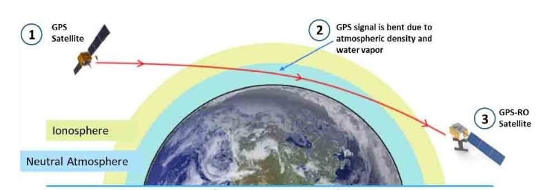
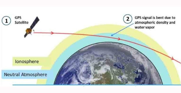
In early June, PlanetiQ announced the successful testing of its first “Pyxis” weather sensor and is setting up for production with BCT. Pyxis collects dense, precise measurements of global temperature, pressure and water vapor — similar to data collected by weather balloons but on a global scale — using a technique called GPS Radio Occultation (GPS-RO). Among the satellite data sources currently ingested into computer weather models, GPS-RO has shown the most cost-effective, highest impact per observation on forecast accuracy. But only a sparse amount of GPS-RO data exists today.
Pyxis is the only GPS-RO sensor in such a small package that is powerful enough to provide more than 10 times the amount of data available from GPS-RO sensors currently on orbit, and to routinely probe down into the lowest layers of the atmosphere where severe weather occurs.
“The small size and weight of the Pyxis sensor — combined with BCT’s high-performance mission experience — will allow us to quickly field a constellation to provide the highest quality, most cost-effective weather data ever available,” said PlanetiQ FounderChris McCormick, who leads PlanetiQ’s instrument team and developed the sensors for the only GPS-RO constellation that has provided operational weather forecast data. “With 12 satellites providing 8 million data points per day, GPS-RO will easily become the most important contributor to weather forecast accuracy at a fraction of the cost of traditional weather satellites.”