“Seen & Heard” is a monthly feature of GPS World magazine, traveling the world to capture interesting and unusual news stories involving the GNSS/PNT industry.

Our Spinning Globe
A highlight of the opening ceremony at the Tokyo 2021 Olympics was a revolving globe above the Olympic stadium. The 1,824 Intel Shooting Star 3 drones formed a complex set of geometrical shapes before transitioning into the games’ emblem, and then a 3D representation of Earth. The Intel Shooting Star 3 drones are designed for entertainment purposes. Each drone weighs 340 grams, is equipped with four extremely bright LEDs, and features real-time kinematic (RTK) GPS for the increased positional accuracy needed for high-resolution animations, sharp imagery and dynamic 3D animations.

Coffee Buzz
Illegal coffee plantations have appeared inside Bukit Barisan Selatan National Park in Indonesia, a key habitat for the endangered Sumatran tiger and other species. Conservationist Matt Leggett noticed in satellite images the declining size of the forest, and sent a team of researchers on an undercover operation on dirt bikes with cameras and GPS receivers, reports the Aug. 11 New York Times Magazine. Leggett’s team mapped hundreds of small coffee farms and investigated the complex chain of custody, which ends with major brand names. No solution has been found, though some farmers have promised to replant the forest over the next 15 years, while others continue to clear park land.
Now that’s heavy
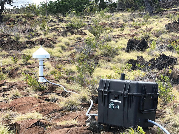
Seven scientific-grade GPS stations are joining a network of 65 that the USGS Hawaiian Volcano Observatory operates on the Hawaiian Islands. As Hawaiian volcanoes erupt and grow, they add weight to the Earth’s surface, causing the Pacific Plate to flex downward and possibly causing the shelf to splinter. Earthquakes this spring in Hawaii likely were related to weight on the underlying crust and mantle from eruptions. Collecting years of data from these stations should help scientists better understand motions of the Pacific Plate, according to researcher Jeff Freymueller, Michigan State University. The first three GPS stations were installed in May; others are being installed this summer.

Camera Upgrade
Nikon could be launching a consumer camera equipped with GNSS instead of only GPS, providing a major upgrade for the geolocation coordinates provided with photo metadata. Filings with the governments of Russia and Indonesia describe a camera dubbed N2014, which will be equipped with GNSS as well as Wi-Fi and Bluetooth. A number of Nikon CoolPix digital cameras have built-in GPS, while other cameras — Nikon D-SLRs and select Nikon 1 — can use optional accessory GPS devices.
