Spirent Communications announced that the Spirent GSS7000 GNSS simulator has been integrated into Microwave Vision Group (MVG) over-the-air (OTA) and passive antenna test systems.
MVG, an antenna measurement solutions company, enables the characterization and evaluation of antennas for testing wireless connectivity, reliability, and standards compliance. MVG near-field test systems perform fast and accurate measurements for OTA tests of antennas designed for satellite communications and other GNSS-enabled products, systems, and networks.
As connectivity in industries such as automotive, aviation and military becomes ever more sophisticated, the need to ensure that all the pieces of technology work together in the way they should increases. The integration of Spirent into MVG test systems enables R&D engineers to incorporate the antenna and the vehicle in a test environment that represents the real-world signal environment as closely as possible while maintaining full control and repeatability.
“Our integration into MVG over-the-air test systems, such as the multi-probe SG24 or StarLab, delivers a cutting-edge testing solution, helping to accelerate the development of next-generation products and systems,” says Adam Price, VP of PNT Simulation at Spirent.
SimOSNMA provides vital test tools for Galileo’s emerging end-to-end security protocol
Spirent Communications plc and Qascom have announced a simulation test solution for the Galileo Open Service Navigation Message Authentication (OSNMA) mechanism.
SimOSNMA is designed to work with Spirent’s GNSS simulation platforms to test OSNMA signal conformance, which will bring new levels of robustness for both civilian and commercial GNSS uses.
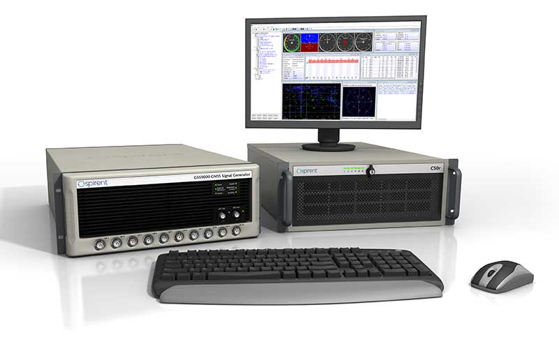
The GSS9000 test system. (Photo: Spirent)
SimOSNMA provides developers with new simulation tools to test for OSNMA, the security protocol that enables GNSS receivers to verify the authenticity of signals distributed from the Galileo satellite constellation. Designed to combat spoofing, OSNMA ensures the data received is authentic and has not been modified in any way. It is now completing the test phase before its formal launch.
SimOSNMA enables developers to simulate and test OSNMA signals and features, allowing GNSS receiver manufacturers and application developers to accelerate and assure development programs.
Qascom has been a significant contributor to the development of Galileo OSNMA. The company helped create the main test vectors for early testing and led the Position Authenticated Tachograph for OSNMA Launch (PATROL) project, which is the European Union Agency for the Space Program (EUSPA) procurement looking at the implementation of OSNMA into automotive and mass-market GNSS receivers.
“During the development of the first OSNMA receiver prototype, we needed a tool that would allow us to run tests in a controlled and repeatable environment, generate reference data, test corner cases and system events that seldomly occur in reality,” said Carlo Sarto, head of Security Engineering Domain Area. Qascom. “SimOSNMA will allow industries and agencies to speed up the development and qualification of their systems.”
Since the inception of the Galileo project, Spirent has provided crucial simulation and test capabilities to many of the key organizations and projects responsible for development of the European Space Agency (ESA) program.
SimOSNMA is available now for Spirent GSS7000 and GSS9000 platforms.
Image: metamorworks/iStock/Getty Images Plus/Getty ImagesChris Hogstrom, Spirent Federal Systems
Inertial navigation systems (INS), like most navigation systems, have evolved through countless iterations and improvements over many years. An INS, unlike other navigation technologies, does not rely on any external signals or inputs to aid navigation. It is, therefore, extremely difficult to spoof, jam or disrupt the system, and solar flares, ground/sky visibility and climate do not affect its ability to aid in navigation — unlike GNSS.
An INS knows where it is going because it knows where it has been. Modern INS use a minimum of three orthogonal accelerometers to measure accelerations in the x, y, z planes and a minimum of three orthogonal gyroscopes to measure the angular accelerations about the x, y, z planes. When the INS is initializing, its current location is fed into the system. After initialization, the INS utilizes the sensor outputs to determine its position relative to its starting point.
The INS made its debut during World War II, where it was used to guide German V2 missiles. At the time, the INS was still rather primitive, using two two-degrees-of-freedom gyroscopes and one integrating accelerometer. It wasn’t until the war’s end that Wernher von Braun and his team developed a stable platform with three single-degree-of-freedom gyroscopes and an integrating accelerometer.
World War II Innovation
Once the war was over, the United States Army acquired many of the lead scientists from the German V2 project and furthered research into INS. The Air Force also had an interest in INS and contracted Northrop Aircraft (now Northrop Grumman) to develop the guidance system aboard the SNARK cruise missile. However, the work under Charles Draper at MIT’s Instrumentation Laboratory spearheaded INS for use in aircraft. Draper was an amateur pilot and quickly saw the benefits that a self-contained system provided over the navigation systems of the day. The developments made by the Instrumentation Laboratory led to the success of the inertial-guided transcontinental flight in 1953.
By the late 1960s, military bombers and aircraft used INS, and by the early 1970s, it was commonplace in commercial aircraft, too. Today, INS technology can be found in aircraft, spacecraft, ships and submarines, as well as smartphones, watches and other wearable tech. It has quickly become an essential enabling technology for autonomous vehicles, and future applications are being studied.
The biggest weakness of INS is that they drift over time. This means that the longer an INS functions, the less accurate it becomes. For this reason, many INS are part of a sensor-fusion system. Incorporating data from many different sensors — such as GPS, a barometer, a compass and INS — a sensor-fusion system combines data through a Kalman filter to determine a more reliable and accurate positioning and navigation solution.
Best of Both Worlds
By combining INS with GPS, you get the benefit of both systems while minimizing their weaknesses. GPS and other GNSS have quickly become the gold standard for accurate positioning, as well as being the only global source of absolute position. Receivers tracking four or more satellites can provide their precise location anywhere on Earth.
However, GPS has significant and well-documented weaknesses. These stem, primarily, from the fact that GPS signals are extremely weak by the time they reach terrestrial users. This means that GPS signals, intentionally or otherwise, are easy to jam, and the broadcast nature of the signals means they are open to a variety of spoofing attacks. Fusion systems using an INS and GPS receiver can rely on GPS when the GPS signal is unobstructed, and switch to the INS solution when GPS is unreliable.
In a world where aircraft are now able to fly themselves and cars are quickly achieving autonomy, our dependence on these sensors is ever-increasing. Autonomous solutions with a navigation sensor suite of multiple sensor types are becoming common. Sensor suites can include other vehicle sensors that aid absolute positioning by sensing parameters such as steering angles, wheel rotations, etc. They are also beginning to incorporate non-GNSS-based RF signals to aid in navigation. Multiple sensors offer increased redundancy, helping achieve the required safety levels and the desired performance boundaries.
High-Mileage Testing
Testing and optimizing these sensor-fusion systems presents a serious challenge, especially in the transportation sector. Testing on a live platform can be hugely expensive and lacks any chance of repeatability. For these reasons, simulation is critical. In addition, representative models must take into account the impact of the environment and the dynamics of the vehicle frame (where sensors are installed) to achieve the requisite realism.
My company, Spirent Federal, has spent the past 20 years building sophisticated and robust test solutions so that sensor-fusion systems can be fully tested and characterized. Thorough testing increases performance and reliability in safety- and mission-critical applications.
Specifically, our GSS7000 and GSS9000 GNSS simulators deliver the precision and fidelity needed for high-performance applications, while our inertial emulation platforms incorporate the key industry models of both inertial measurement units (IMUs) and embedded GPS/inertial (EGIs) for dynamic integrated testing in the lab.
We work closely with major defense contractors, such as Northrop Grumman and Honeywell, to provide robust test solutions as well as alternative RF PNT simulation capabilities.
In addition, hardware-in-the-loop incorporation with ultra-low latency, modeling signal propagation in a 3D environment — and the ability to “shift left” with software-only testing — are what helps to make Spirent Federal the trusted partner in sensor fusion development.
Chris Hogstrom is an engineer with Spirent Federal Systems.
Enables greater collaboration and faster product development through I/Q data streaming
Spirent Federal Systems has released SimIQ, software that allows for earlier and more efficient GNSS testing during product development.
From software-in-the-loop through to final-form testing, SimIQ enables developers to collaborate across the full design lifecycle through the creation, sharing and replay of I/Q data files.
“SimIQ Capture allows developers to test their receiver algorithms in the earliest stages of design, minimizing costs and giving designers confidence as they proceed to the hardware design phase.”
SimIQ has been developed to meet the growing need to test GNSS capabilities earlier to accelerate product development, while simultaneously reducing costs by identifying issues prior to the purchase of hardware components.
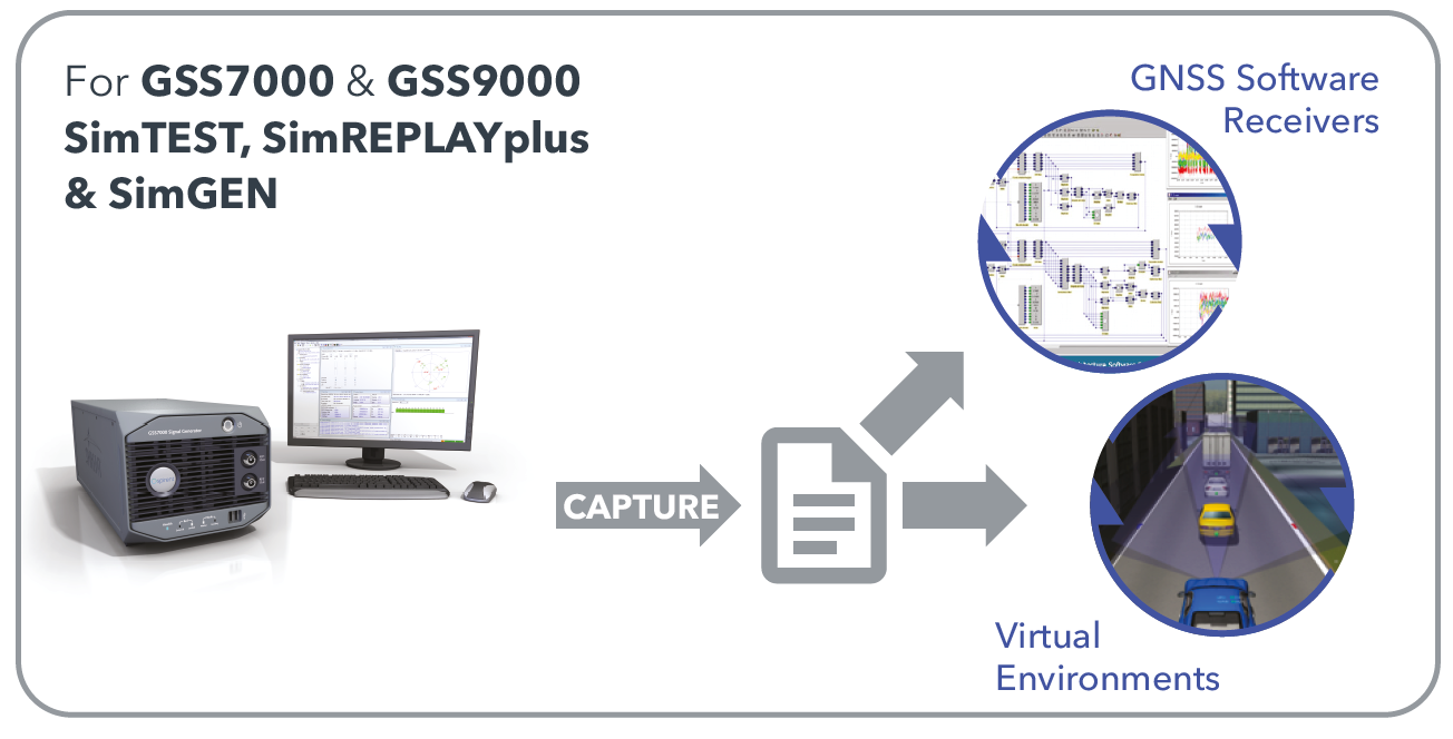
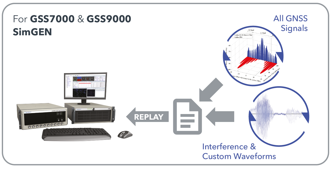
For developers using Spirent’s GSS9000 and GSS7000 simulators, SimIQ extends multi-frequency, multi-constellation simulation capabilities to cover software-only testing needs through the capture and replay of high-fidelity I/Q data files.
Housed in a single system, SimIQ reads and generates I/Q data with two major components, SimIQ Capture and SimIQ Replay.
SimIQ Capture. Allows Spirent GNSS simulators to generate I/Q files containing all the GNSS signal data required to test the algorithms, conformance, and performance of software receivers. It enables the recording of GNSS I/Q data into files hosted in the simulator, helping development and testing teams to validate positioning, navigation and timing (PNT) algorithms before expensive hardware designs.
SimIQ Capture: Record I/Q data from Spirent GNSS simulators into files. (Image: Spirent)
SimIQ Replay. Enables the simulator to read any I/Q file containing GNSS data. In addition, it facilitates the generation of RF from pre-recorded interference signals and custom waveforms. The flexibility and unrivalled signal generation architecture of Spirent’s hardware enables the generation of these signals from I/Q files, while maintaining fidelity and quality due to Spirent’s unrivalled signal generation architecture.
SimIQ Replay: Generate RF with Spirent GNSS simulators form I/Q files. (Image: Spirent)
Test engineers can accelerate development, and thus save time and resources, by using Spirent simulators during the entire design lifecycle. The new software will bring significant benefits to developers in the defense and aerospace sectors.
“SimIQ Capture allows developers to test their receiver algorithms in the earliest stages of design, minimizing costs and giving designers confidence as they proceed to the hardware design phase,” said Jen Smith, Spirent Federal’s director of Business Development.
SimIQ will be available to new and existing customers beginning in the fourth quarter of 2020.
GNSS testing solutions company Spirent Communications has added BeiDou Phase 3 signals to its GNSS RF constellation simulators.
BeiDou Phase 3 signals are available immediately on the GSS7000 and GSS9000 simulators, and existing users can obtain the software upgrade by contacting Spirent.
The addition of these new signals to the GSS7000 and GSS9000 simulators follows the launch of the first two Beidou-3 satellites in November 2017. Two others were launched Jan. 12.
Phase 3 of the Chinese BeiDou system will extend its coverage from Asia to the entire world. It will provide receiver developers and integrators with additional GNSS signals to make positioning, navigation and timing systems more accurate, and help to support new applications, such as autonomous vehicles.
The new signals will use the same carrier frequencies as the GPS and Galileo systems, so chipset manufacturers and device developers will need to test integrated designs to avoid problems caused by confusing data from different GNSS.
“By offering the BeiDou Phase 3 signals, our customers can test their designs well before the system is fully operational, which is expected in 2020,” said Stuart Smith, lead product manager at Spirent Communications. “With signals already starting to appear, it is important for developers to have test tools that can ensure devices will successfully make use of all GNSS signals.”