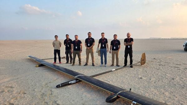
UAVOS has successfully completed of a test flight of Mira Aerospace’s high-altitude pseudo-satellite (HAPS) ApusNeo 18, with UAVOS providing full engineering and technical support. A key objective of the flight was to evaluate the jointly developed optoelectronic, gyro-stabilized aircraft payload onboard device (POD) by obtaining imagery from altitudes between 3,000 and 12,000 meters.
During the mission, the POD captured high-resolution imagery with precise geolocation data from an altitude of 12,000 meters, achieving a Ground Sample Distance (GSD) of up to two meters. The test took place in Abu Dhabi, UAE, and lasted continuously for 48 hours.
“The data-relay station trials were conducted in preparation for upcoming commercial flights in Europe, planned for the coming months,” Aliaksei said.
The optoelectronic gyro-stabilized aircraft POD is equipped with an innovative automatic temperature control system for heating and cooling electronic modules, ensuring reliable operation in the stratosphere at temperatures as low as -70°C under rarefied air conditions.
The system also provides radio communication at distances exceeding 100 km. The gimbal’s optical unit allows observation within a ±90°C range with high-precision angular positioning. The payload housing features an aerodynamically optimized design, and the total payload weight is 3.6 kg.
“The successful cooperation with Mira Aerospace reflects our commitment to continuously advancing the capabilities of both companies,” said Aliaksei Stratsilatau, founder and CEO of UAVOS. “We also continue to work toward our ultimate goal of leveraging the HAPS platform for multiple applications, including mobile connectivity, border monitoring, mapping, forest fire detection, and emergency response.”
To extend the HAPS operational range, the test flight also incorporated a data-relay network based on ground modem repeaters. Each repeater is capable of providing a coverage area of up to 200 km.
“The data-relay station trials were conducted in preparation for upcoming commercial flights in Europe, planned for the coming months,” Aliaksei said.
Thales Alenia Space has signed a €43 million contract for the Euro High-Altitude Platform Systems (HAPS) demonstration project. EuroHAPS was selected by the European Commission on July 20, 2022, for collaborative defense research and development projects from the European Defense Fund.
EuroHAPS aims to develop several stratospheric demonstrators for missions designed to improve intelligence, surveillance and reconnaissance and communications capabilities. Project partners include companies from Italy, Spain, Germany and France.
The project will conduct flight demonstrations for three types of complementary stratospheric platforms: A reduced-scale Stratobus from Thales Alenia Space, a solar-powered airship designed for long-endurance missions and offering large payload capacity, Hybrid High Altitude Airship from the Italian Aerospace Research Centre capable of generating extra lift with a wing airfoil, and autonomous stratospheric balloon system from ESG and TAO consisting of a series of three altitude-controllable balloons.
These three types of platforms are complementary and feature different operating times, capacity and operational restrictions. They will give Europe a broad spectrum of solutions to meet a variety of different requirements.
The platforms will test a range of missions, including lidar observation to detect and classify targets at sea or on land and the ability to detect them in environments with vegetation cover. Communications intelligence and electronic intelligence missions will also be tested, as well as a meshed broadband communications network for air and land players.
HAPS offer a new opportunity to complement ground-based, satellite-based or airborne assets with unique capabilities tailored to operational requirements. These flight demonstrations of HAPS will enable demonstrations of different platforms and address the main technical risks associated with these new technologies while refining operational requirements to ultimately enable development of future HAPS systems.
M3 Systems Belgium’s Haps-Augmented Search-And-Rescue Demonstrations System (HASARDS) project is looking to improve positioning of the global collaborative Copas-Sarsat search-and-rescue system by using its high-altitude platform system (HAPS).
The project is designing features for the system, such as carrying out geolocation with HAPS imagery and establishing communication between individuals in distress and emergency services.
While conducting HASARD, researchers were able to document system enhancements, execute a piloted flight-test campaign to create a realistic distressed aircraft carrying a second-generation beacon and future HAPS, and develop and operate a second-generation beacon signal simulator and HAPS system simulator.
Researchers found that using HAPS independent of Cospas-Sarsat adds value to search-and-rescue operations, providing location details via data fusion and georeferenced imagery while relaying communication between SAR teams and people in distress.
UAVOS has completed a successful test flight of the ApusDuo solar-powered high-altitude platform system (HAPS). The test flight, at a European Flight Center, was conducted continuously for 11 hours and reached altitudes of 15,000 meters.
The ApusDuo successfully achieved more than two dozen test points, including energy balance validation, power and propulsion performance, and propeller revolutions per minute evaluation. The team also tested aircraft motor control efficiency, which was refined following previous test flights.
After operations in Europe, UAVOS plans to transport ApusDuo to Argentina. The company is accelerating preparations to perform the next phase of test flights in the stratosphere.
ApusDuo is a stratospheric UAV running on solar power, and is meant to provide persistent local satellite-like services. Built with carbon-fiber composites, it can be landed, re-equipped with multitask payloads and re-deployed. It is also capable of flying autonomously from takeoff to landing and can be remotely operated from its ground-control station.
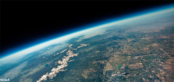
View from a weather balloon at 100,000 feet. (Photo: NOAA)
“We’re at 103,000 feet. As you look up the sky looks beautiful but hostile. …Can see for over 400 miles. The sky [above me] is absolutely black. …I can see the beautiful …deep, dark, indescribable blue [sky below], which no artist can ever duplicate. It’s fantastic.”
— Capt. Joseph W Kittinger, USAF, Operation Excelsior III, August 16, 1960
This month, our journey begins in the future. Imagine you are in Alamogordo, New Mexico, a town with a rich history in America’s space program. You are here for a proof-of-concept, real-world exercise. After two years spent training, you are on a team that will test the viability of a stratospheric airframe, or high-altitude platform station (HAPS).
The exercise is a joint venture between several large corporations and U.S. government agencies. The HAPS began as a telecommunications support platform, but now includes many different industries. It will test backup systems for GPS and other sensing technologies.
Remote sensing is an obvious use case, and sensors are onboard to collect hyperspectral and thermal images, synthetic aperture radar, lidar, magnetometry, weather and other types of data. Some equipment is mounted on top of the platform to point toward space to monitor satellites and orbital debris. Also aboard are are satellite relays and space-based communications systems. Additionally, a Hubble-like observatory will support NASA research.
On the ground at the command center, other teams are working on the project. A mapping and survey team is in the field to ground truth the precision, accuracy and resolution of the HAPS data.
Autonomous vehicle manufacturers are testing telemetry data from the HAPS for improved precision navigation. Teams of imagery analysts and geospatial analysts are assessing the quality and value of the products, including full-motion video live-streamed from the HAPS.
Aerospace engineers are studying the performance of the airframe and monitoring its structural integrity. Meteorologists are providing upper air wind and weather forecasts. Several teams of engineers are managing various robotics systems onboard, and more scientists and engineers from multiple companies and agencies are testing their equipment.
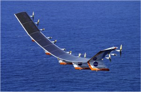
The solar-powered Helios in flight. (Photo: NASA/Aerovironment)
Your Mission as a Stratonaut
Most tests and modifications are being handled remotely, but some require replacing the systems. This can only be accomplished by physically going to the sub-orbital station. Imagine this is your job.
You are a remote sensing technician specially designated as a stratonaut. Your training familiarized you with the various systems onboard. You trained how to use your pressure suit — its dangers, risks and capabilities — and how to interface with the suit’s augmented reality system. You know how the HAPS operates, its schematics, and the interiors of the three connected dirigibles. You can navigate your way around the HAPS and access the various decks and compartments as well as the sensors, equipment, charging ports, fuel cells and motors. You can fly the drones, dock with the station, and enter its hangar bays. You can do maintenance on the autonomous robots and the remote-controlled robots onboard the station. You know the security and safety protocols. All this you know and more; and, if things go wrong, you know what to do.
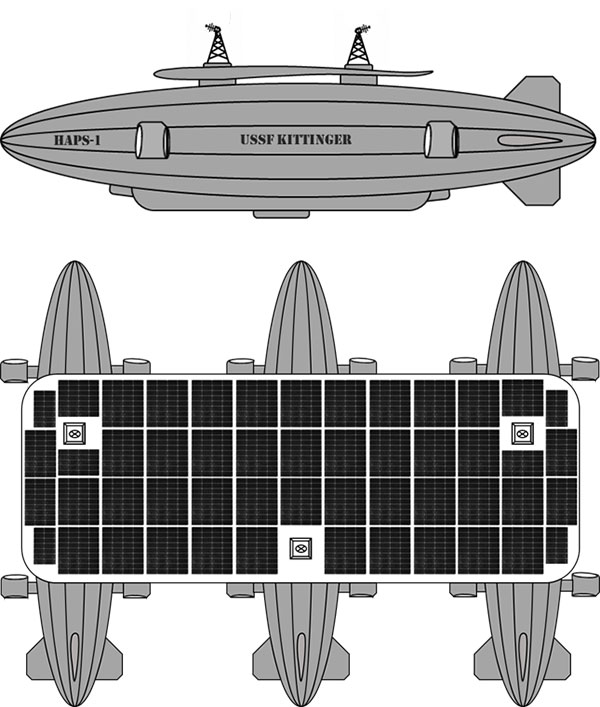
Vision of the Alpha, Bravo and Charlie HAPS stations. (Image: William Tewelow)
On this mission day, it’s early morning. Sunlight is beginning to pierce the sky above the Alamogordo base station. Two technicians are helping you into your pressure suit. Another technician at a desk has your helmet hooked up to the computer. The LED lights encircling the facemask blink slowly, indicating data is being uploaded. The augmented reality face shield glows a soft blue as the data flashes across it.
Overnight at the command center, operators controlled descent of the HAPS from 100,000 feet. It takes 10 hours to reach 65,000 feet, the altitude for your rendezvous with the station. You will fly up to the HAPS in a cargo delivery drone and dock at the forward hangar bay of Station Bravo (the second dirigible). You’ll be installing an enhanced high-resolution hyperspectral sensor array in the station’s lower observation deck.
While you are busy with the installation, the autonomous robot onboard will be in the hangar bay, swapping out the station’s spent fuel cells with fresh ones carried up by the cargo drone. Each weighs 250-pounds. After this task, the cargo drone will fly to Stations Alpha and Charlie and swap out their spent fuel cells.
Once all three are completed, the cargo drone will return to Station Bravo and take you to the top of Station Charlie to install a satellite laser relay (SLR) communications system. A remote-controlled robot operated by the engineering team at base command will meet you and carry the SLR up to the tower. While you are installing the SLR, the cargo drone will dock and recharge for your return trip. The entire mission will take seven-hours and 45 minutes.
“Many functions currently done with satellites could be performed for tactical and operational commanders using near-space assets, much more cheaply and with much greater operational utility. By operationally grouping near-space with space, the functional expertise synergies would allow much more efficient delivery of space effects to the joint commander.”
— Lt. Col. Edward B. Tomme, Ph.D., USAF, Air Power Research Institute
Two Types of Pseudolites
High-altitude, long-endurance (HALE) airframes — also referred to as pseudo-satellites, pseudolites and stratolites — are of two types.
Heavier than air. The heavier-than-air (HTA) type is a lightweight, fixed-wing aircraft with extremely long wingspans. It can stay aloft for a month or more.
HTAs are limited to carrying small payloads. They typically rise to 100,000 feet during the day powered by their solar cells, and at night descend to 60,000 feet, repeating this cycle until the batteries need replacing. The HTA platform is good for short-term missions over a broad area of interest because it normally flies in large circular patterns.
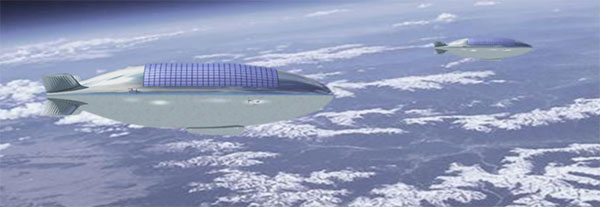
Lighter than air. The other type of pseudo-satellite is a lighter-than-air (LTA) airframe. The typical example is a dirigible, but these platforms can take on many shapes and sizes. LTAs can be enormous, with lifting capacities upward of 100,000 pounds. They operate as geostationary platforms loitering indefinitely over an area of interest and remain at the same altitude day and night. An LTA can last for 10 years or more.
The best solution is a combination of the two. A large LTA can serve as a base station to support several small HTA platforms.
“Together, NASA and the Space Force seek to advance, protect and sustain activities in, from and to space. This is truly a new era of strategic collaboration that will benefit commercial, civil and national security in space.”
— John W. Raymond, General, Chief of Space Operations, United States Space Force
A stratosphere-based telecommunications platform proposed by the Elefante Group. (Image: FCC)
HAPS Alliance
Furthering the development of the pseudo-satellite industry is a consortium of 49 companies and universities called the HAPS Alliance, which advocates for investment in this area.
The stratosphere has become increasingly important for commercial interests and national security. HAPS can provide the best of what manned aircraft operating at lower altitudes can offer, combined with the benefits of satellites, minus much of the downside of each.
Limits of aircraft. Aircraft operating at lower altitudes offer high resolutions and targeted collection. They can be easily retasked and rerouted, and equipment can be easily repaired or replaced. Aircraft are limited by constraints of time, fuel, weight, distance and weather.
Limits of satellites. Satellites, on the other hand, provide broad area coverage and long-term, operational endurance, but they are 240 miles or more above the Earth traveling at 17,500 miles per hour, or they are 18,000 miles above the Earth to maintain a geostationary orbit. It is a trade-off between resolution and dwell time.
Other drawbacks of satellites are their expense. Launching is costly and recovery is nearly impossible to make repairs. Doing so is impractical.
HAPS do not have those limitations. They can provide long-term, persistent operations over an area of interest at very high resolutions. They also can carry a complete package of sensors and equipment with the additional benefit that most everything can be repaired or replaced with minimal cost.
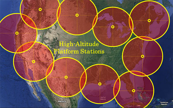
Locations of HAPS to cover the borders of the Continental United States. (Image: William Tewelow)
How HAPS Will Improve Geospatial Data
These systems are going to improve geospatial information. HAPS will improve spectral resolutions by a factor of 10x or better. The improved location accuracy data will impact navigation, surveying, construction, emergency services, logistics, transportation, aviation, agriculture and most other industries.
The HAPS will act in tandem with cellular networks on the ground to improve internet connectivity and telecommunications. They will improve national security while monitoring the effects of climate change, deforestation, urban sprawl, ozone, pollution and natural disasters such as floods, forest fires, tornadoes, hurricanes and more.
Provided testing proves HAPS a success, the pseudosatellite era is going to greatly impact most everyone’s life. If you are lucky, you might actually become a stratonaut. If you are interested, now is the time to prepare.
“This point of observation commands an area nearly 50 miles in diameter. The city, with its girdle of encampments, presents a superb scene. I have pleasure in sending you this first dispatch ever telegraphed from an aerial station.”
— Thaddeus S. C. Lowe, First Chief Aeronaut, Union Army Balloon Corps, Civil War, 1861
William Tewelow
William Tewelow is a Senior Aeronautical Information Specialist for the Federal Aviation Administration. He is a designated Geographic Information Systems Professionals (GISP). He served on special assignment to the U.S. Department of Transportation and led a national strategic geospatial initiative under the authority of the White House Open Data Partnership. He was among the first in the nation to earn a Geospatial Specialist Certification from the U.S. Department of Labor while working at NASA Stennis Space Center.
He is a 2016 graduate of the FAA’s management fellowship Program for Emerging Leaders. He has degrees in Geographic Information Technology and Intelligence Studies and is earning a master’s degree in Organizational Leadership with a focus on Performance Management. He is a mentor with the FAA’s National Mentor Program.
Tewelow retired from the U.S. Navy after serving 23 years as a Geospatial and Imagery Intelligence Specialist, a Naval Aviator, a Meteorologist, and a Tactical Oceanographer earning three achievement medals. He is married, enjoys traveling, connecting people, solving problems, and interested in new technology. His favorite quote is, “A man’s mind changed by a new idea can never go back to its original dimension.” ~ Oliver Wendell Holmes
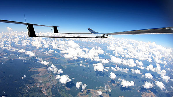
UAVOS Inc. has performed a series of successful flight trials with High Altitude Pseudo Satellite (HAPS) ApusDuo, testing its unique control system.
The test flights confirmed that UAVOS’s control system allows aircraft with a large-wing elongation to fly in unstable atmospheric conditions. The ApusDuo aircraft successfully copes with turbulence, actively changing the bend of the wings.
The total flight time of UAVOS solar-powered test aircraft is more than 1,000 hours. Test flights took place at an altitude of up to 62,000 feet (19,000 meters).
UAVOS’s control system does not require the installation of wing mechanization. This reduces the aircraft’s weight by 30% or more, improves reliability and simplifies wing production for lower manufacturing costs.
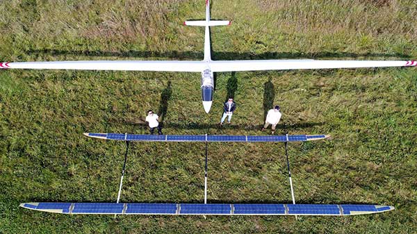
The ApusDuo drone weighs about 95 lbs (43 kg) and has a wingspan of 49.2 ft. It is launched by a winch. The aircraft is built on the tandem principle, where two of the wings are located one after another with a small elevation difference.
ApusDuo is controlled by changing the geometry of the aircraft. It is designed to linger at an altitude of about 60,000 feet (18,000 m) for months at a time for surveillance or to provide a temporary boost to communications.
Additional test flights are planned for this year, said Aliaksei Stratsilatau, UAVOS CEO and lead developer.
The ApusDuo project is the second generation of UAVOS’ HAPS solar airplane. (Photo: UAVOS)
UAVOS has joined the High Altitude Platform Station (HAPS) Alliance to promote the use of high-altitude solar-powered autonomous aircraft for facilitating global research missions, communication, connectivity, intelligence, surveillance and reconnaissance from the stratosphere.
UAVOS joined HAPS to collaborate with member companies towards accelerating the development and adoption of HAPS technology into the evolution of the high-altitude unmanned platforms market.
UAVOS’s HAPS knowledge is based on test flights for more than 1,000 hours of flight tests at altitudes of up to 66,000 feet (20,000 meters). The ApusDuo project is the second generation of UAVOS’ HAPS solar airplane.
HAPS platforms are autonomous, high-altitude, ultra-long endurance aircraft powered by solar energy. They are designed to boost internet connectivity worldwide, provide a long continuous monitoring of the Earth’s surface, create a network of autonomous repeaters and high-speed data signals. High-altitude unmanned platforms operate in the stratosphere, above ground infrastructure but below satellites, allowing for near ubiquitous coverage, which avoids ground clutter and significant latency issues.
The HAPS Alliance, originally an initiative from HAPSMobile and Loon, has members from the companies across the aerospace, technology and telecom industries.
Telecom, technology and aviation industry leaders join forces to create the HAPS Alliance to connect more people, places and things by using the stratosphere
A group of global industry leaders is forming the HAPS Alliance, an association of world-leading telecommunications, technology, aviation and aerospace companies united in promoting the use of high-altitude vehicles in the Earth’s stratosphere to eliminate the digital divide and bring connectivity to more people, places and things worldwide.
Members who have committed to join the HAPS Alliance include
SoftBank Corp.’s HAPSMobile Inc.
Alphabet’s Loon LLC
AeroVironment Inc.
Airbus Defence and Space
Bharti Airtel Limited
China Telecom Corporation Limited
Deutsche Telekom AG
Intelsat US LLC
Nokia Corporation
SoftBank Corp.
Telefónica S.A.
Telefonaktiebolaget LM Ericsson
The HAPS Alliance is being created so member companies can
collectively advocate for High Altitude Platform Station (HAPS) business development with the relevant authorities in various countries
build a cooperative HAPS ecosystem
develop common product specifications and promote the standardization of HAPS network interoperability
All of these activities will be key to the Alliance’s aim of addressing diverse social issues and creating new value by providing telecommunications network connectivity worldwide through the utilization of high altitude vehicles.
Polar stratospheric clouds. (Photo: Paul Newman, GSFC/NASA)
The Alliance, originally an initiative from HAPSMobile and Loon, will have members from participating leading companies across the aerospace, technology and telecom industries to carry out the Alliance’s activities.
The launch of the HAPS Alliance follows an April 2019 announcement between HAPSMobile and Loon where the companies formed a strategic alliance to advance the use of high-altitude vehicles.
High-altitude network connectivity platforms operate in the stratosphere — above ground infrastructure but below satellites — allowing for near ubiquitous coverage that avoids ground clutter and significant latency issues.
These advantages make such vehicles a promising solution for expanding mobile coverage to areas where connectivity is lacking — mountainous terrain, remote islands, marine regions and developing countries — as well as for IoT and 5G use-cases. The HAPS Alliance seeks to create an ecosystem to support next-generation global connectivity needed to revolutionize the world’s mobile networks.
High-altitude pseudo-satellites (HAPS) are platforms that float or fly at high altitude like conventional aircraft but operate more like satellites. (Image: ESA Earth Observation Graphics Bureau)
The European Space Agency (ESA) is considering extending its activities to a new region of the sky via a novel type of aerial vehicle, a missing link between drones and satellites.
High-altitude pseudo-satellites, or HAPS, are platforms that float or fly at high altitude like conventional aircraft but operate more like satellites — except that rather than working from space, they can remain in position inside the atmosphere for weeks or even months, offering continuous coverage of the territory below.
The best working altitude is about 20 kilometers, above the clouds and jet streams, and 10 kilometers above commercial airliners, where wind speeds are low enough for them to hold position for long periods.
From such a height they can survey the ground to the horizon 500 km away, variously enabling precise monitoring and surveillance, high-bandwidth communications or back up to existing satellite navigation services.
Several ESA directorates have teamed up to investigate their potential, explains future-systems specialist Antonio Ciccolella.
“For Earth observation, they could provide prolonged high-resolution coverage for priority regions, while for navigation and telecoms they could shrink blind spots in coverage and combine wide bandwidth with negligible signal delay,” Ciccolella said.
“ESA is looking into how these various domains can be best brought together.”
“We’ve been looking into the concept for the last 20 years but now finally it’s becoming reality,” explained Earth observation specialist Thorsten Fehr.
“That’s come about through the maturing of key technologies: miniaturised avionics, high-performance solar cells, lightweight batteries and harness, miniaturisation of Earth observation sensors and high-bandwidth communication links that can deliver competitively priced services.”
Navigation engineer Roberto Prieto Cerdeira added, “There’s obvious potential for emergency response. They could also be employed semi-permanently, perhaps extending satnav coverage into high, narrow valleys and cities.”
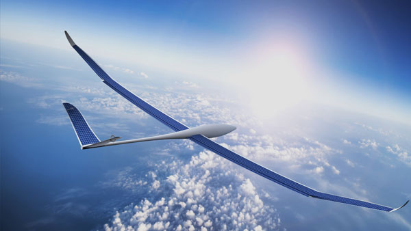
The QinetiQ-designed and Airbus-owned Zephyr-7 solar-powered unmanned aircraft holds the world flight endurance record at 14 days. (Photo: Airbus)
European companies have already unveiled product lines. For instance, Airbus has developed the winged, solar-powered Zephyr, which in 2010 achieved a world record 14 days of continuous flight without refuelling.
The Zephyr-S is designed to fly payloads of a few tens of kilograms for up to three months at a time, with secondary batteries employed to keep it powered and aloft overnight. A larger Zephyr-T version now in preparation will support larger payloads and power needs.
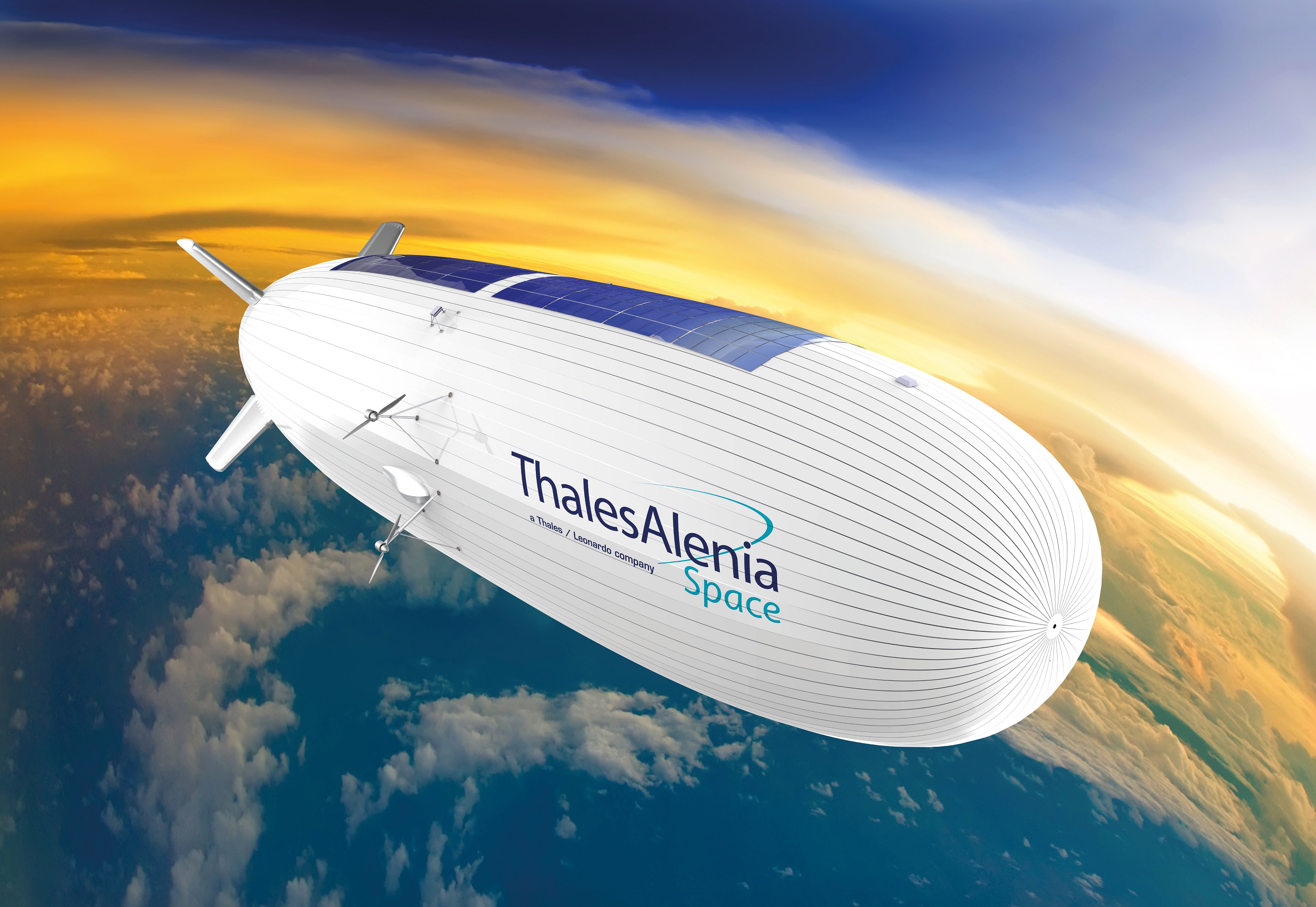
The first flight is projected for 2021 for Thales Alenia Space’s Stratobus airship. (Artist’s rendering: Thales Alenia Space/Briot)
Meanwhile, Thales Alenia Space is preparing the lighter-than-air Stratobus, with its first flight expected in 2021.
The buoyant Stratobus airship can carry up to 250 kilograms, its electric engines flying against the breeze to hold itself in position, relying on fuel cells at night.
Many other firms are also developing vehicles, payloads and services. Last month saw them gathered at ESA’s inaugural workshop, together with representatives of potential customers, including the European Defence Agency, Frontex — the EU agency tasked with Europe’s border management — and EU Copernicus environmental monitoring services.
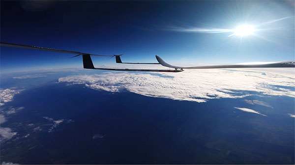
Airbus’s double-tailed Zephyr-T variant HAPS aircraft is designed to support larger payloads, keeping them aloft for months at a time. (Image: Airbus)
“This was the first meeting of its kind in Europe, with more than 200 HAPS experts” explains Juan Lizarraga Cubillos, from ESA’s telecoms area.
“We heard from them on the needs, opportunities and critical issues within the field, particularly as a complement for existing satellite services, to start preparing a future ESA programme.”
ESA regards the vehicles as a valuable way of establishing applications that complement its satellites while also accelerating space technologies through early, high-altitude flight testing.
The point was also made that market acceptance of HAPS would come down to their efficiency and cost-effectiveness — and the best way to show that would be through demonstration projects.
“We have to fly them,” remarked Alvaro Rodriquez of the EU’s Satellite Centre. “The technology is there, all the ingredients are there, now it’s time to mix them into a nice recipe.”
Thales Alenia Space’s Stratobus is topped with solar panels, powering its propellers to fly against the wind at 20 km for prolonged periods of service. (Image: Airbus)
High-altitude pseudo-satellites (HAPS) are platforms that float or fly at high altitude like conventional aircraft but operate more like satellites. (Image: ESA Earth Observation Graphics Bureau)
The European Space Agency (ESA) is considering extending its activities to a new region of the sky via a novel type of aerial vehicle, a missing link between drones and satellites.
High-altitude pseudo-satellites, or HAPS, are platforms that float or fly at high altitude like conventional aircraft but operate more like satellites — except that rather than working from space, they can remain in position inside the atmosphere for weeks or even months, offering continuous coverage of the territory below.
The best working altitude is about 20 kilometers, above the clouds and jet streams, and 10 kilometers above commercial airliners, where wind speeds are low enough for them to hold position for long periods.
From such a height they can survey the ground to the horizon 500 km away, variously enabling precise monitoring and surveillance, high-bandwidth communications or back up to existing satellite navigation services.
Several ESA directorates have teamed up to investigate their potential, explains future-systems specialist Antonio Ciccolella.
“For Earth observation, they could provide prolonged high-resolution coverage for priority regions, while for navigation and telecoms they could shrink blind spots in coverage and combine wide bandwidth with negligible signal delay,” Ciccolella said. “ESA is looking into how these various domains can be best brought together.”
“We’ve been looking into the concept for the last 20 years but now finally it’s becoming reality,” explained Earth observation specialist Thorsten Fehr. “That’s come about through the maturing of key technologies: miniaturised avionics, high-performance solar cells, lightweight batteries and harness, miniaturisation of Earth observation sensors and high-bandwidth communication links that can deliver competitively priced services.”
“There’s obvious potential for emergency response,” added Navigation engineer Roberto Prieto Cerdeira. “They could also be employed semi-permanently, perhaps extending satnav coverage into high, narrow valleys and cities.”
The QinetiQ-designed and Airbus-owned Zephyr-7 solar-powered unmanned aircraft holds the world flight endurance record at 14 days. (Photo: Airbus)
European companies have already unveiled product lines. For instance, Airbus has developed the winged, solar-powered Zephyr, which in 2010 achieved a world record 14 days of continuous flight without refuelling.
The Zephyr-S is designed to fly payloads of a few tens of kilograms for up to three months at a time, with secondary batteries employed to keep it powered and aloft overnight. A larger Zephyr-T version now in preparation will support larger payloads and power needs.
The first flight is projected for 2021 for Thales Alenia Space’s Stratobus airship. (Artist’s rendering: Thales Alenia Space/Briot)
Meanwhile, Thales Alenia Space is preparing the lighter-than-air Stratobus, with its first flight expected in 2021.
The buoyant Stratobus airship can carry up to 250 kilograms, its electric engines flying against the breeze to hold itself in position, relying on fuel cells at night.
Many other firms are also developing vehicles, payloads and services. Last month saw them gathered at ESA’s inaugural workshop, together with representatives of potential customers, including the European Defence Agency, Frontex — the European Union (EU) agency tasked with Europe’s border management — and EU Copernicus environmental monitoring services.
Airbus’s double-tailed Zephyr-T variant HAPS aircraft is designed to support larger payloads, keeping them aloft for months at a time. (Image: Airbus)
“This was the first meeting of its kind in Europe, with more than 200 HAPS experts,” said Juan Lizarraga Cubillos, from ESA’s telecoms area. “We heard from them on the needs, opportunities and critical issues within the field, particularly as a complement for existing satellite services, to start preparing a future ESA programme.”
ESA regards the vehicles as a valuable way of establishing applications that complement its satellites while also accelerating space technologies through early, high-altitude flight testing.
The point was also made that market acceptance of HAPS would come down to their efficiency and cost-effectiveness — and the best way to show that would be through demonstration projects.
“We have to fly them,” said Alvaro Rodriquez of EU’s Satellite Centre. “The technology is there, all the ingredients are there, now it’s time to mix them into a nice recipe.”
Thales Alenia Space’s Stratobus is topped with solar panels, powering its propellers to fly against the wind at 20 km for prolonged periods of service. (Image: Airbus)