“Seen & Heard” is a monthly feature of GPS World magazine, traveling the world to capture interesting and unusual news stories involving the GNSS/PNT industry.
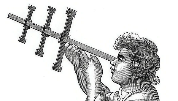
Free navigation history course
Photo: Harvard University
Harvard University offers PredictionX: Lost Without Longitude, a free online course that examines the evolution of navigation from ancient methods to modern technologies. The program explores the science and history of navigation, focusing on the challenges of determining longitude before GPS existed. It highlights key advancements, such as John Harrison’s marine chronometer and the Longitude Prize. Through multimedia content — including videos, infographics and Worldwide Telescope tours — the course is designed to demonstrate how centuries of advancement in navigation enabled humanity to achieve milestones such as landing on the moon.
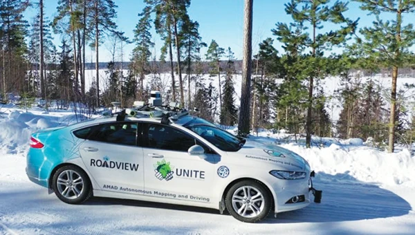
Self-driving cars collect geospatial data
Photo: Finnish Geospatial Research Institute
In Finland, self-driving cars are being used to collect geospatial data to address urban challenges. The ARVO autonomous vehicle from the Finnish Geospatial Research Institute is equipped with high-precision sensors that map its environment in real-time, collecting information on road conditions, urban vegetation as carbon sinks and factors influencing flood risks. In partnership with Aalto University and funded by the European Regional Development Fund, this initiative seeks to explore various uses of this data, such as city planning, environmental monitoring and infrastructure management.
Stopping scammers
Photo: Carlos Alvarez / iStock Editorial / Getty Images Plus / Getty Image
Google has taken legal action against a network of scammers responsible for creating more than 10,000 fake business listings on Google Maps. The scammers fabricated profiles targeting urgent service industries and bolstered them with fake reviews to appear credible. Victims were misled into contacting these fake businesses, which then sold their personal information as “leads” to legitimate service providers without consent. Google has removed the fake listings and is suing individuals involved in the scheme, CBS News reported.
Mapping Uganda’s disappearing tropical glaciers
Photo: guenterguni / E+ / Getty Image
Project Pressure, in collaboration with UNESCO and the Uganda Wildlife Authority, conducted an expedition to the Rwenzori Mountains to map the region’s disappearing tropical glaciers. The team created the first 3D model of Mt. Stanley’s glaciers and installed monitoring equipment, revealing that Mt. Speke and Mt. Baker have lost their glaciers entirely, while the Stanley Plateau Glacier has shrunk by 29.5 percent since 2020 and is heavily fragmented. The project aims to continue monitoring the glacial retreat, develop mitigation strategies and engage the local community in ongoing research.
China’s BeiDou GNSS is newer, has more features, is more accurate, and has more satellites in the skies of more nations than the venerable U.S. GPS, according to Sarah Sewall, Executive Vice President for Strategic Issues at IQT.
Image: BeiDou program
More than that, it is one example of “a new form of great power competition that most in the U.S. government don’t recognize,” she said. China is providing superior precision, navigation, and timing information to enhance its diplomatic, economic and military power and the United States cannot afford to cede this area of longstanding advantage.
In a recent paper published by Harvard’s Belfer Center for Science and International Affairs, “China’s BeiDou: New Dimensions of Great Power Competition,” Sewall and co-authors Tyler Vandenburg and Kaj Malden outline their finding that China’s version of GPS is part of a longstanding effort to join the technological ranks of leading nations and leverage its capabilities to achieve geopolitical advantage in many areas.
“First, the global reach of BeiDou ensures that the Peoples’ Liberation Army is no longer dependent on another nation’s satnav. China’s economy — and those of other nations relying on BeiDou — can continue to function even if GPS is degraded or denied,” Sewall stated. “This may increase Beijing’s incentives to attack other national satellite capabilities.”
“BeiDou is also an economic driver for the Chinese economy and innovation. The output of China’s commercial space and navigation services industry has increased by tens of billions in the last decade, and new applications such as precision agriculture and self-driving cars show no sign of slowing,” Sewall continued.
The focus of Sewall’s paper, though, is the way BeiDou supports China’s Belt and Road and Digital Silk Road initiatives to gain influence and leverage around the world. She points out that in cases where BeiDou provides the most accurate positioning, navigation, and timing (PNT) data, particularly in the global south, China may be able to hold much of another nation’s economy hostage.
The BeiDou constellation has more satellites than GPS or any other system. It also has more than ten times the monitoring stations in other countries than have been deployed for GPS. As a result, in many places, particularly in the developing world, BeiDou’s accuracy is much better.
Her assessment of BeiDou’s technical superiority received some unexpected support recently from a government advisory board on GPS. It reported that “GPS’s capabilities are now substantially inferior to those of China’s BeiDou,” and urged the administration to regain U.S. leadership in the field.
Being newer and more advanced makes it easier for China to encourage other nations to use BeiDou signals and purchase specialized equipment, especially when equipment purchases are heavily subsidized by the Chinese government.
This is important because systems such as GPS and BeiDou provide more than just directions to the nearest coffee shop. Their precise PNT signals are used for everything from synchronizing cellphone networks and industrial machine controls, to time stamping financial transactions, and coordinating electrical grids. GPS has been called “the silent utility” because signals are used in almost every technology.
“It is very difficult for government leaders in the developing world to turn down discounted infrastructure and opportunities for economic development,” Sewall said. “Even if they know that tying that infrastructure to Chinese signals may give the CCP [Chinese Communist Party] a future on/off switch to their economies.”
The West and the United States in particular, faces challenges confronting China’s efforts with BeiDou, according to Sewall.
“Many in government equate national power with military power, but that’s a narrow and insufficient formulation, particularly in the 21st century,” Sewall said. “American officials under appreciate China’s efforts to create commercial technology dependencies abroad. The United States has left a vacuum in the developing world that our industry is seemingly unable to fill in the face of competition from Chinese firms that are heavily supported by their government.”
Sewall describes a Chinese “tech stack” being exported that include BeiDou services as part of Belt and Road and Digital Silk Road. It is comprised of a hierarchy of equipment that includes network cables, servers, and cell phones.
“We don’t really have a democratic approach to help foreign nations make meaningful technology choices. We risk ceding global infrastructure to China if we fail to help Western firms offer their own integrated products and services to the developing world,” she said.
If we recognized this new form of great power competition, America could easily leap frog China in areas such as satellite navigation, said Patrick Diamond, a member of the President’s Advisory Board on GPS.
“We could provide higher accuracy GPS and make signals much more secure though internet delivered authentication,” Diamond said. “We could offer complementary terrestrial systems to GPS that would give other nations their own sovereign source of precise time and location while at the same time cooperating with our signals from space.”
“Competing effectively with China in the coming decades will require Americans to think more holistically,” Sewall said, “from realizing that GPS is not just about the military and space, to understanding that national power is more than the ability to prosecute war.”
The U.S. Cluster Mapping website provides research in clusters combined with 52+ economic indicators, forming an online, open-data, open-source platform that allows users to make more informed decisions about economic development, both in the United States and abroad.
The website is evolving to serve as the national portal to track cluster-led economic development efforts, identify best practices, and spread new data and insights. The interactive webinar will walk participants through use the tool and show how best to use it.
The U.S. Cluster Mapping Project is a national economic initiative that is led by Harvard Business School’s Institute for Strategy and Competitiveness (ISC) in partnership with the U.S. Department of Commerce and U.S. Economic Development Administration. Directed by Michael Porter, the ISC studies competition and its implications for company strategy; the competitiveness of nations, states, and regions; and solutions to social needs such as health care, innovation, and corporate responsibility.
Speakers include Sarah Jane Maxted, the U.S. Cluster Mapping Project manager at ISC focusing on clusters and regional economic growth, and Christian Ketels, ISC principal associate and research team leader.