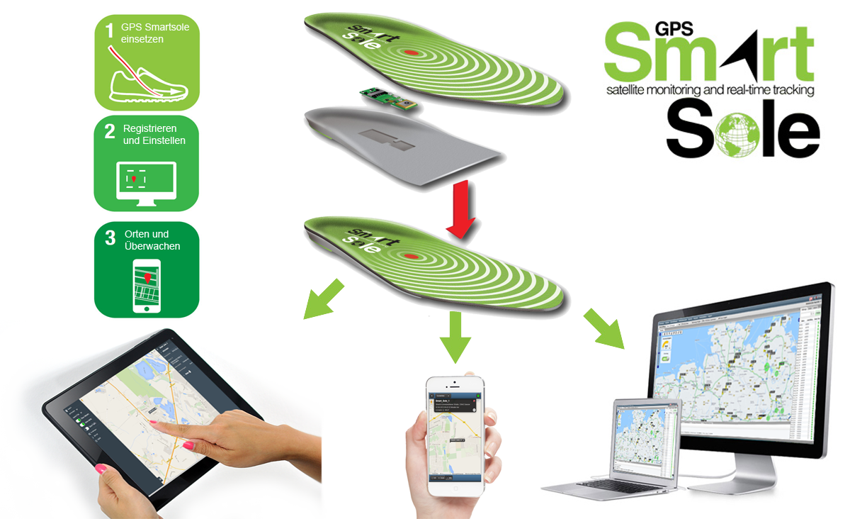
GTX Corp will begin testing its new Cat M1 LTE SmartSoles across North America, Europe and Australia, and will begin the regulatory certification process for FCC/IC and CE.
The following week will begin the device network certification with Verizon, which will be providing the cellular connectivity for the North American market. GTX will also be testing with Orange and Telefonica for connectivity in Europe and Australia.
“With over 200 back orders and increasing demand every day, we intend to begin production as soon as we complete testing and certification, expected sometime next month, and then immediately start fulfilling all pre-orders and backorders first,” said Andrew Duncan, GTX Corp. director.
The patented and award-winning GPS SmartSoles were designed to address Alzheimer’s and autism challenges, where those diagnosed are at risk of wandering and becoming lost. Wandering is a safety issue with far-reaching implications for the person with the disease, their caregiver, law enforcement and healthcare providers.
GPS SmartSoles are placed in the wearer’s shoes. They contain a Nordic Cat M1 LTE GPS module connected through cellular networks that send a GPS location to the GTX central monitoring website and app. GTX is also upgrading its tracking app both for iOS and Android.
The SmartSoles can also be used by people at risk of kidnapping, such as government employees, journalists and corporate executives. SmartSoles come in three trim-to-fit sizes for men, women, and children, are water resistant, include an inductive charging pad, and are assembled in Rhode Island.
With more than 3 million people infected around the world, the coronavirus pandemic is pushing health authorities to research and develop new ways to react to critical situations, according to drone company Quaternium.
Public and private organizations are racing to develop experimental treatments and vaccines to fight COVID-19. At the same time, many local companies are trying to think outside the box to find ways to minimize the effects of the crisis. “Our current situation has opened up opportunities for innovative solutions, and we are best seeing them within the drone industry,” said Alicia Fuentes, CEO at Quaternium.
Photo: Quaternium
Drones have been deployed in the effort to contain the spread of the pandemic. “We’ve seen drones distributing public information, like voice messages, to those not following social distancing measures as well as delivering medical samples and spraying disinfectants to urban areas,” Fuentes said.
Unmanned solutions are easy to operate and can be quickly mobilized. “In addition to reducing the risk of health of sanitary workers, drones also get to unreachable places; they have become a versatile tool for managing this health catastrophe,” Fuentes said.
In Europe, several startups like Quaternium, Drone Tools and Manna Aero, and in the U.S. and Canada, companies such as Zipline and Draganfly are all exploring how they can help in their regions and neighboring countries to decrease the aftermaths of the pandemic and save more lives.
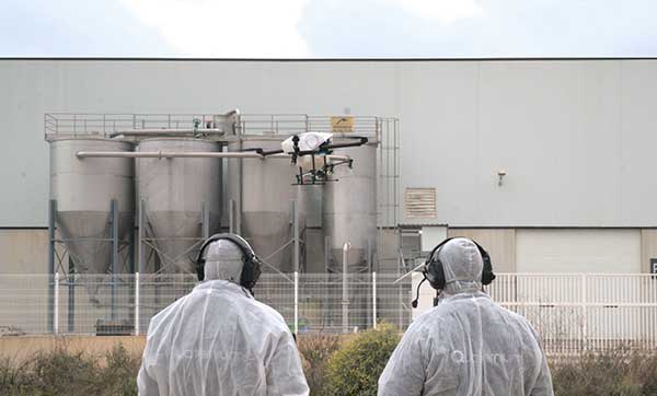
Quaternium demonstrates drone spraying
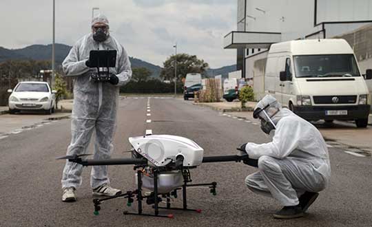
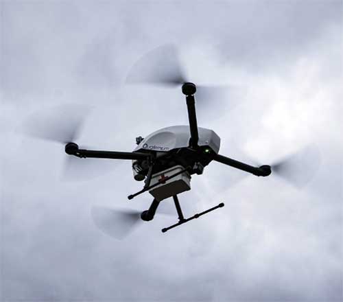
Quaternium has successfully been testing its hybrid drone, HYBRiX, to spray disinfectant products in Spain, showing how drone technology may serve in critical situations and how the company can support public authorities to help end the spread of the virus.
The company has also demonstrated aerial logistics solutions by delivering essential items to people in critical situations. Long-endurance drones can deliver supplies specifically for COVID-19 efforts, such as masks and gloves to first responders. HYBRiX can also deliver medicine to patients who can’t safely get to a pharmacy.
In the U.S., police departments are using drones from Impossible Aerospace to limit personal contact and share COVID-19 information, to reach out to homeless people (who are particularly at risk for coronavirus) and to monitor and enforce social distancing.
These are some of the areas where drones are being used to fight COVID-19.
Delivery drones
Due to COVID-19 being so contagious, it’s safer if human-to-human contact is minimized. UAVs are proving to be a valuable tool when delivering medical samples and essential items to health personnel. Several drone companies have made tests showing the crucial role that unmanned logistics can play against the spread of COVID-19.
Inform and prevent
“In the last weeks, we have seen speakers being mounted on drones to help inform people outdoors and prevent public gatherings. Drones can also be found flying with banners advising people on how to be more precautious when going outside,” Fuentes said. The mobility and flexible use of these UAVs make the mission of security agencies simpler, while avoiding close contact with the population, she said.
Aerial spraying and disinfection
First in China and now in Europe and the U.S., agriculture drones — originally designed to spray liquids on crops — are being adapted to spray disinfecting chemicals in public spaces and impacted areas. Experts have discovered that coronavirus is mainly transmitted by touching contaminated surfaces. This new virus has shown to be very contagious and resistant, staying on some surfaces up to 30 days, which makes disinfectant spray vital to helping reduce transmission mechanisms.
The battle with COVID-19 has just begun. Cases are continuing to rise in and outside of Europe. “Now more than ever, public authorities and private companies need to join forces in order to grow stronger and overcome this pandemic together,” Fuentes said.
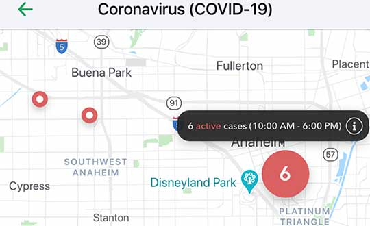
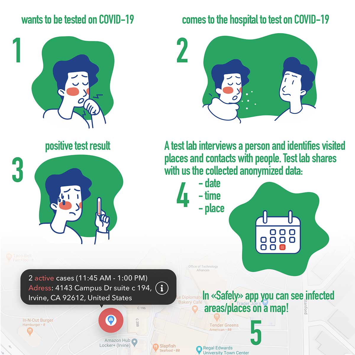
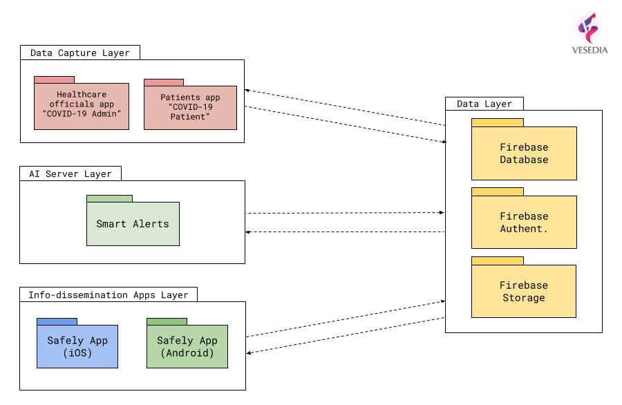
Vesedia Mobile Technologies is offering to deploy its location platform to help control the COVID-19 pandemic through tracking and dissemination of information about “at risk” infection areas and places, and times when they were known to have infection — a process referred to as contact tracing.
Vesedia is a technology startup with a suite of mobile apps for children and family safety based on a location-sharing platform and location-tracking artificial intelligence (AI).
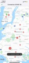
“The platform would warn people that passed through these places at matching times,” explained Ruslan Shalaev, co-founder and team leader, Vesedia. Shalaev developed a popular app for family safety: Safely – Family Location; and serves as a lead research on user-location monitoring AI in an academic partnership with Binghamton University and Lviv National University.
The Safely – Family Location app could be used to disseminate data on infection areas, and access to the API would be provided for other application developers and sites, Shalaev said.
The platform would be applicable after the initial pandemic is contained. “It would help with restarting the economy and resuming normal business operations by providing a mechanism to track, control and suppress new outbreaks,” Shalaev said.
Data Sources
Under the plan, people that test positive to COVID-19 would be asked to provide information about public places they visited in the preceding days, and at what times. Individuals that provide the information can confirm that it’s accurate from their phone location history.
The information would be anonymized by healthcare officials, and entered into a database that would be publicly accessible via a website and mobile app.
Image: Vesedia
Mobile App
The mobile app aspect is especially valuable from information dissemination standpoint, because other people in “at risk” areas can receive automated alerts to self-quarantine and get tested based on their device location history.
The app is ready and available for download in Google Play and Apple App Store.
Image: Vesedia
Image: Vesedia
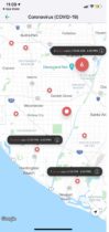
Workflow diagram
Workflow diagram. (Image: Vesedia)
System architecture
System architecture. (Image: Vesedia)
Approach validity
The approach has been successfully applied in Singapore, but without active alerts, with dissemination of information being done manually. The Singapore government was able to contain the virus without shutting down businesses, schools, public transit and restaurants.
Vesedia location apps
Vesedia is a tech startup founded in 2016 by SUNY Binghamton Computer Science graduates. It developed SmartAI location tracking and sharing platform. Its apps include Safely – Family Location, Virtual Nanny, MeetCity – Live Events, Blind Date, Sponter – Social Network in partnership with Lviv National University and Binghamton University. The apps are available for download in the Google Play and Apple App stores.
Vesedia research on “Location-Based Behavioral Patterns Modeling” was published at Institute of Electrical and Electronics Engineers – Intelligent Data Acquisition and Advanced Computing Systems (IEEE/IDAACS) conference in Metz, France in 2019.
A team of medical researchers and bioethicists at Oxford University published results in Science that offer further understanding of coronavirus transmission.
The evidence is enabling several international partners to assess the feasibility of developing mobile apps for instant contact tracing in record time.
If rapidly and widely developed, the mobile apps could help to significantly slow transmission rates and support countries emerging from lockdowns as restrictions are gradually eased.
Partners include the Norwegian Institute of Public Health (FHI) and NHSX, a joint unit comprised of teams from NHS England and the UK’s Department of Health & Social Care.
Critically, the researchers suggest a mobile app can help slow the spread of infection until vaccines and antiviral treatments become widely available.
“We need a mobile contact tracing app to urgently support health services to control coronavirus transmission, target interventions and keep people safe,” explained Christophe Fraser, Oxford University’s Big Data Institute, Nuffield Department of Medicine, an a lead author on the Science paper.
“Our analysis suggests that about half of transmissions occur in the early phase of the infection, before you show any symptoms of infection,” Fraser said. “Our mathematical models also highlight that traditional public-health contact tracing approaches provide incomplete data and cannot keep up with the pace of this pandemic.”
The project is co-led by David Bonsall, senior researcher at Oxford University’s Nuffield Department of Medicine and clinician at Oxford’s John Radcliffe Hospital. “The mobile app concept we’ve mathematically modeled is simple and doesn’t need to track your location,” Bonsall said.
Anonymous alerts
“It uses a low-energy version of Bluetooth to log a memory of all the app users with whom you have come into close proximity over the last few days,” Bonsall said. “If you then become infected, these people are alerted instantly and anonymously, and advised to go home and self-isolate.
“If app users decide to share additional data, they could support health services to identify trends and target interventions to reach those most in need,” Bonsall said.
The authors argue that a mobile app can reduce transmission at any stage of the epidemic: in countries or regions where the epidemic is just emerging, at the peak of the epidemic, or to support a safe transition out of restricted movement or lockdown.
It could also help to reduce the serious social, psychological and economic impacts caused by widespread lockdowns. Critically, the researchers suggest a mobile app can help slow the spread of infection until vaccines and antiviral treatments become widely available.
Good citizenship
“A contact tracing app can foster good citizenship by alerting people at risk,” Fraser explained. “It can also help ease us out of confinement if we know we’ve not been in contact with anyone infected we can leave home safely, whilst still protecting our loved ones and avoiding a broader resurgence of coronavirus in our community.”
Given the level of infection across much of Europe, the team believe ongoing development of a mobile app partnership across the union would massively reduce transmission and avoid a resurgence in the number of cases, providing an opportunity for all citizens using mobile contact tracing apps to contribute towards ending the epidemic. An app strategy could also be used by low- and middle-income countries, earlier in the epidemic, to rapidly control transmission and get ahead of the epidemic now.
The Oxford team highlight that the mobile contact tracing app should still be combined with isolation of cases, tracing and quarantine of contacts, physical distancing, scaled-up diagnostic testing, decontamination and hygiene measures.
As Bonsall explains “If the mobile app is widely adopted in any country, and combined with other critical interventions such as physical distancing and widespread testing, our models suggest the epidemic could be brought under control. This app is a tool for each and every person affected to contribute towards protecting their health services, supporting vulnerable people and simultaneously gradually releasing communities out of extended quarantine.”
Rigorous ethical standards
Today’s Science study highlights the importance of rigorous ethical standards underpinning the successful and appropriate use of mobile phone technology in addressing the coronavirus pandemic, including a number of ethical requirements needed to foster well-founded public trust and confidence.
“With transparent and inclusive ethical oversight to ensure genuine public trust, it is possible to both save lives and protect civil liberties,” said Michael Parker, director of the Wellcome Centre for Ethics & Humanities and one of the paper’s authors.
“The app should be opt-in, provide secure data storage and privacy protection, and be informed by public and user engagement at every stage of implementation. With these guarantees and, if widely installed by users across a country or regional bloc, a mobile app could even help to end the epidemic,” Parker said.
Official apps only
As mobile apps launch over the coming weeks and months, the Oxford research team urges people to support official apps, developed by trusted institutions, and their partners, such as the mobile contact tracing apps under advanced assessment in several European countries.
Fraser concludes, “Our hope is to support communities with life-saving information as the pandemic worsens and help to release countries from large-scale isolation. The maths is clear: the more people that use a contract tracing app the better chance we have of getting ahead of this epidemic and eventually stopping it in its tracks. If a country reduces the epidemic growth rate to below zero, the epidemic will rapidly decline and eventually stop. Together we can make this possible.”
Download results
Results of a mobile-app-focused survey from a large representative sample of the UK population (1,055 respondents) conducted March 20-22 are available here. Other country surveys are also available for Italy, Germany and France, currently in each language.
Drone Delivery Canada is reaching out to the healthcare industry for use case applications for drone deliveries related to COVID-19.
The Toronto-based company, which has been designated an essential workplace by the Ontario Provincial Government, seeks use cases from health care organizations (hospitals, seniors’ homes, medical labs and related organizations).
If organizations in healthcare and related industries have a use case, they should reach out immediately to DDC at [email protected] and also contact their local government official to support their use case.
“In the news we are seeing COVID-19 related drone applications around the world, and Canada can particularly benefit from having DDC, a drone logistics leader, in its own backyard,” said Michael Zahra, president and CEO of DDC. “The current situation is an ideal use-case for our proven drone logistics solution to: limit person-to-person contact; bring needed medical and pharmaceutical supplies to Aboriginal, remote, rural and suburban communities; transport blood samples to laboratories for testing and deliver other relevant supplies needed for Canada to effectively manage the current situation.”
Communities in need of resources can access location intelligence technology at no cost with six-month trial
Location intelligence company Esri is making its software available to public and private sector organizations fighting the coronavirus (COVID-19) pandemic.
The COVID-19 outbreak has escalated rapidly across the globe, and with municipalities struggling to respond, Esri has built out resources to help organizations understand the potential impact of the disease on public health, as well as potential community risk areas and their capacity to respond.
A COVID-19 GIS Hub site provides much of this essential data, including case locations and social vulnerability, that communities and health organizations can use to inform their response.
To help public health agencies and other organizations jump-start their response, Esri is providing the ArcGIS Hub Coronavirus Response template at no cost through a complimentary six-month ArcGIS Online subscription with ArcGIS Hub. The template includes examples, materials, and configurations to rapidly deploy a local ArcGIS Hub environment. ArcGIS Hub is a framework to build a website to visualize and analyze the crisis in the context of an organization’s or community’s population and assets.
“Esri has always prioritized assisting communities during large-scale emergencies and natural disasters,” said Jack Dangermond, Esri founder and president. “For the past 25 years, our Disaster Response Program provides data, software, configurable applications, and technical support for emergency operations. We consider it part of our mission to provide these services free of cost during this time of national crisis.”
For more information on the complimentary software and the disaster relief support, visit esri.com/disaster.
With Coronavirus all over the news, it’s actually encouraging to hear that China is making high-level efforts to contain the infection: two isolation hospitals built in just one week in Wuhan where the outbreak began, travel restrictions inside China, very few people being allowed to leave the country, enforced mask-wearing, and local communities in neighboring provinces blocking visits by outsiders.
Two drone-related stories caught my attention, both in China and connected to the virus outbreak — one where drones were being used to enforce “wear-a-mask (see video), and another where disinfectant was being dispensed by drones.
Photo: Xag
It’s not exactly clear who was behind recent drone flights that broadcast live warnings to people without protective masks on the streets — some villages in rural China were apparently overflown and people were advised to wear a mask while outdoors.
Around Beijing, similar activities were maybe down to well-intentioned social media people and traffic police.
XAG, which has fielded 42,000 agricultural spraying drones in China, is urging authorities to use its drones for widespread disinfectant spraying, and has set up a significant fund to support these activities. The company claims its drones can disinfect a local community in less than four hours, and may already have done so.
Medical transport drones. Staying with the medical theme, Aquiline Drones (AD) in Cincinnati is a drone company operating under a Federal Aviation Administration (FAA) Part 135 Air Carrier Certificate, and is working on a system to transport human organs for transplants.
VyrtX is an organ transport company in Ohio that has teamed with AD, with the object of creating a highway-in-the-sky across the state to overcome ground delivery delays. Apparently around 25% of precious transplant organs don’t make it in time to be used; they are lost to the patients on lengthy wait lists — and many people are dying as a consequence. There are supposedly enough donors, but organs deteriorate during ground transport and desperate transplant candidates are losing out badly.
So the next step for VyrtX and AD are custom-designed drones for life-saving rapid transport between donor and transplant hospitals. VyrtX is working with the U.S. Air Force Research Laboratory in Dayton, the Ohio UAS Centers and four Ohio organ procurement organizations to develop the air corridor and begin rapid organ transport by drone across the state.
The University of California, San Diego, Health (UC San Diego Health) is joining an increasing number of health organizations in developing a drone system for blood and documentation transport between its facilities. Collaborating with the UPS Flight Forward drone delivery program and with Matternet, medical payloads will travel between Moores Cancer Center and Jacobs Medical Center. The Center for Advanced Laboratory Medicine, about 1.5 miles north, will be added provided initial test flights work out well.
Trained professionals will load and operate the drones, which will follow predetermined, low-risk flight paths and will carry no cameras. (Photo: UC San Diego Health)
UPS Flight Forward is another company that was granted (FAA) Part 135 Air Carrier authorization and is already operating a UAS delivery program at WakeMed Hospital in Raleigh, N.C.. UPS Flight Forward is also planning with CVS to deliver prescriptions and other products to CVS pharmacy customers.
Another drone medical supplies delivery system in Tanzania ran an operational trial in the fall of 2018. Wingcopter (a German drone manufacturer), Deutsche Gesellschaft für Internationale Zusammenarbeit (GIZ) GmbH and DHL flew medicines from the mainland to an island. The DHL Parcelcopter completed a 60-km route autonomously in around 40 minutes, for a total of 2,200 km flown during the pilot project.
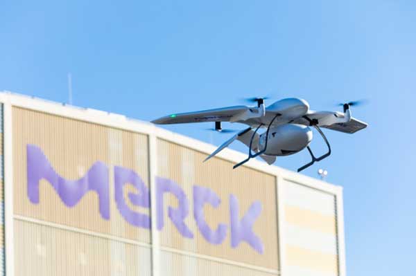
Building on these earlier trials, Wingcopter is now working with Merck and the Frankfurt University of Applied Science to demonstrate a drone delivery system between two Merck facilities in Germany. The object is to show the benefits of direct drone airborne transport over trucks for moving small packages between a Merck lab in Gernsheim to its headquarters in Darmstadt.
The first flight was recently accomplished over roughly 15.5 miles between the facilities, carrying a sample of pigments.
Photo: Wingcopter
The BVLOS (beyond visual line of sight) flight passed over a dense metropolitan area, power lines, railways, and roadways. Benefits include time savings of around an hour, provided much greater savings at some times, and avoided significant ground vehicle emissions.
To sum up, drones being used to help combat coronavirus, to reduce time and costs for the transport of medical samples and supplies over medium distances, and there’s a spin-off with potential commercial promise, too. It’s a good month for the drone industry…
Drone service slated to begin February 2020, with goals of enhancing efficacy, reliability and predictability of delivering medical products between hospitals and laboratories.
In February, the University of California (UC) San Diego Health will launch a pilot project to test the use of unmanned aerial vehicles to transport medical samples, supplies and documents between Jacobs Medical Center, Moores Cancer Center and the Center for Advanced Laboratory Medicine (CALM), speeding delivery of services and patient care currently managed through ground transport.
Trained professionals will load and operate the drones, which will follow predetermined, low-risk flight paths and will carry no cameras. (Photo: UC San Diego Health)
The program is a collaboration with UPS, which received in September 2019 the Federal Aviation Administration’s (FAA) Part 135 Standard certification and authorization to use unmanned aircraft systems for a drone delivery program, and Matternet, a Mountain View, California-based drone systems developer for health care institutions. This latest effort builds upon the UPS and Matternet drone project already taking place at WakeMed Health and Hospitals, a private, non-profit health care system based in Raleigh, N.C.
“Currently, medical samples that must be transported between health care sites are carried by courier cars, which are naturally subject to the variabilities of traffic and other ground issues,” said Matthew Jenusaitis, chief administrative officer for innovation and transformation at UC San Diego Health. “With drones, we want to demonstrate proof-of-concept for getting vital samples where they need to be for testing or assessment more quickly and simply. It’s another way to leverage emerging technologies in a way that can tangibly benefit our patients.”
The project calls for medical professionals at Jacobs Medical Center, located on the east health campus of UC San Diego in La Jolla, to pack payloads, such as blood samples or documents, into a secure container that attaches to one of Matternet’s M2 rechargeable battery-powered drones.
The drones will follow predetermined, low-risk flight paths, initially between Jacobs Medical Center and special landing sites at Moores Cancer Center, located less than a mile away and within visual line of sight under the FAA’s Part 107 rules, and then subsequently at CALM, which is near the Jacobs Medical Center. The flights will take only minutes to complete and will be monitored by remote operators. The drones will carry no cameras.
In May 2018, the FAA designated the city of San Diego as one of nine lead participants in the regulators’ Integration Pilot Program. UC San Diego was also approved by the FAA to test the use of drones in transporting lab specimens and pharmaceuticals throughout its health system.
“Right now, most biological samples must travel between sites by courier car, within designated hours,” said James Killeen, MD, clinical professor of emergency medicine and director of information technology services at UC San Diego School of Medicine. “That leaves the system vulnerable to the vagaries of road congestion, accidents, construction and more. Travel time can be slow and unpredictable. A drone can fly over such obstacles in a much more direct way, and take just a few minutes to cover the same distance.”
Esri is hosting a free one-hour webinar “Effective Vector-Borne Disease Surveillance and Control” on Thursday, May 26, at 11 a.m. PDT. The webinar will help city and county staff implement a complete workflow that is driven by understanding the location of information.
Geographic information systems (GIS) technology plays a vital role in monitoring and eradicating mosquitos, and ramping up to fast and efficient response when outbreaks occur. The webinar will introduce how the Esri ArcGIS platform can help create smart communities when collecting and analyzing data, improving operations and response times, and communicating critical information with the public.
When vector-borne disease outbreaks occur, fast, effective response protects people from infection and its consequences,” said Este Geraghty, Chief Medical Office and Health Solutions Director, Esri. “Integrated pest management programs respond through the vital functions of prevention, surveillance, and control activities. Temporal and spatial information are critical to those efforts to curb the spread of disease. Organizations that harness the power of a location platform can achieve faster, more efficient response.”
Speakers are Este Geraghty, chief medical officer and health solutions director, Esri; and Jared Shoultz, health and human services technical specialist, Esri.
For more information on how Esri solutions help with vector-borne disease surveillance and control, visit go.esri.com/vector-ready.
Reynolds is director of Inta Communication Ltd. and a long-term Brussels observer writing on many aspects of European government policy and implementation for a range of clients and publications. He is the contributing editor for GPS World’s new quarterly e-newsletter, EAGER: the European GNSS and Earth Observation Report.
The annual summit, held in the historic Munich Residenz, is an conference with global impact dealing with satellite navigation. The one-of-a-kind convention of high-ranking worldwide speakers from industry, science and governments provides the participants with a broad overview and different perspectives on the latest developments in the field of GNSS.
Reynold’s session, GNSS and Sciences for Life, will cover maritime search and rescue (SAR), precision agriculture and livestock management, personal fitness and emergency medical attention.
Other sessions include:
GNSS Program Updates — Global systems, chaired by Hank Skalski, Department of Transportation, DOT Liasion to Air Force Space Command, Peterson Air Force Base, USA
GNSS Program Updates — Regional and augmentation Systems, chaired by Dr. Todd Walter, Stanford University, CA, USA
GNSS in the Southern Hemisphere and Equatorial Regions, chaired by Prof. Vidal Ashkenazi, Chief Executive of U.K.-based Nottingham Scientific Ltd, Nottingham, UK
Precise Positioning Technology in Agriculture and Forestry, chaired by Dr. Herbert Landau, Managing Director, Trimble Terrasat GmbH, Hoehenkirchen, Germany
Legal Issues of GNSS Timing, chaired by Dr. Ingo Baumann and Dr. Oliver Heinrich, Partner, BHO Legal, Cologne, Germany
Plus, expect a brand-new conference format for this session:
The GNSS Knowledge Triangle: Tying the Knot Between Education, Research and Industry, chaired by Dr. Fabio Dovis, Associate Professor, Politecnico di Torino, Turin, Italy
The summit is part of the efforts of the Bavarian government and the cluster on aerospace and satellite navigation to stimulate applications and services in this high-tech field.
GTX Corp, an IoT platform in the personal location GPS wearable and wandering-assistive-technology business, has completed a successful SmartSole pilot program transitioning into a commercial launch in Germany. SmartSoles also launched this month in the United Kingdom.
GTX Corp has signed a reseller distribution agreement with Way4Net, a solution provider in geo-locating and tracking monitoring services. Way4Net placed its first commercial order, with scheduled delivery dates beginning this month and continuing monthly over the next six months.
GPS SmartSoles. GTX Corp’s flagship product, the GPS SmartSoles, are an unobtrusive monitoring and tracking solution for those who suffer from Alzheimer’s, dementia, autism, TBI and other memory disorders and have a tendency to wander.
The SmartSoles are placed in the wearer’s shoes and contain a GPS tracking chip connected through a cellular network that sends a signal to GTX Corp’s proprietary IoT platform monitoring website or smartphone app, showing the exact location of the individual wearing them. They come in several trim to fit sizes for both men and women, are water resistant, made with the highest-quality electronic components and assembled in Rhode Island, U.S.A.
The Dementia Problem. Germany has a population of 83 million people with approximately 1.6 million, or 2 percent of its population who are afflicted with dementia and Alzheimer’s. Just this week, German football legend Gerd Muller announced receiving treatment for Alzheimer’s disease. This disease is not limited only to the senior population — 24,000 people ages 45-65 are already diagnosed throughout Germany.
Many people mistake dementia as a natural consequence of getting older, when it is actually the result of damage to brain cells that affect memory. Dementia affects close to 50 million people worldwide today with no cure for this syndrome on the horizon.
“For us, the solution of GTX SmartSole is one of the best technologies to increase the quality of life of vulnerable people with the symptoms of dementia, Alzheimer’s, autism and other cognitive memory disorders,” said Eric Gnass, CEO of Way4Net. “We are very pleased to introduce this unique product on the German market.”
Transition to Commercial Launch. “We are extremely pleased to have another successful pilot transition into a commercial launch and we are proud to partner with a well-entrenched company like Way4Net,” said Andrew Duncan, GTX Corp director of business development. “We are currently investing a lot of resources in Germany, which is where we design and manufacture our GPS and cellular chip, and have recently signed an M2M agreement with Telefonica Germany which will support our connectivity throughout Europe. Between our launch in Germany and launch last week in the U.K., I plan to stay in Europe for another two weeks working with our partners and chip manufactures on our next-gen SmartSole, expected out in early 2016.”
Wearable fitness trackers such as FitBit could help military patients recover quicker, according to Col. Deydre Teyhen, an official with from the Defense Health Headquarter’s Office of the Surgeon General. The trackers could help patients with musculoskeletal conditions gauge how much physical activity they can handle without exacerbating their injuries, Teyhen told an audience at a conference hosted by tech association, AFCEA and reported by NextGov.
Device-agnostic software is needed to allow soldiers to use the devices they already own, she said. “The question becomes, is it a one-size-fits-all solution?”
For instance, some patients begin to feel better before their soft tissue heals fully, and start walking around more, which could inhibit their recovery process, she explained. An effective system might send that patient a notification on their fitness tracker to say, “‘You’ve done great, at 1,000 to 2,000 steps a day,’ and it gives you a warning … ‘You might actually be doing too much and you might cause a setback.’ If you give them that warning in real time, then they can change their behaviors.”