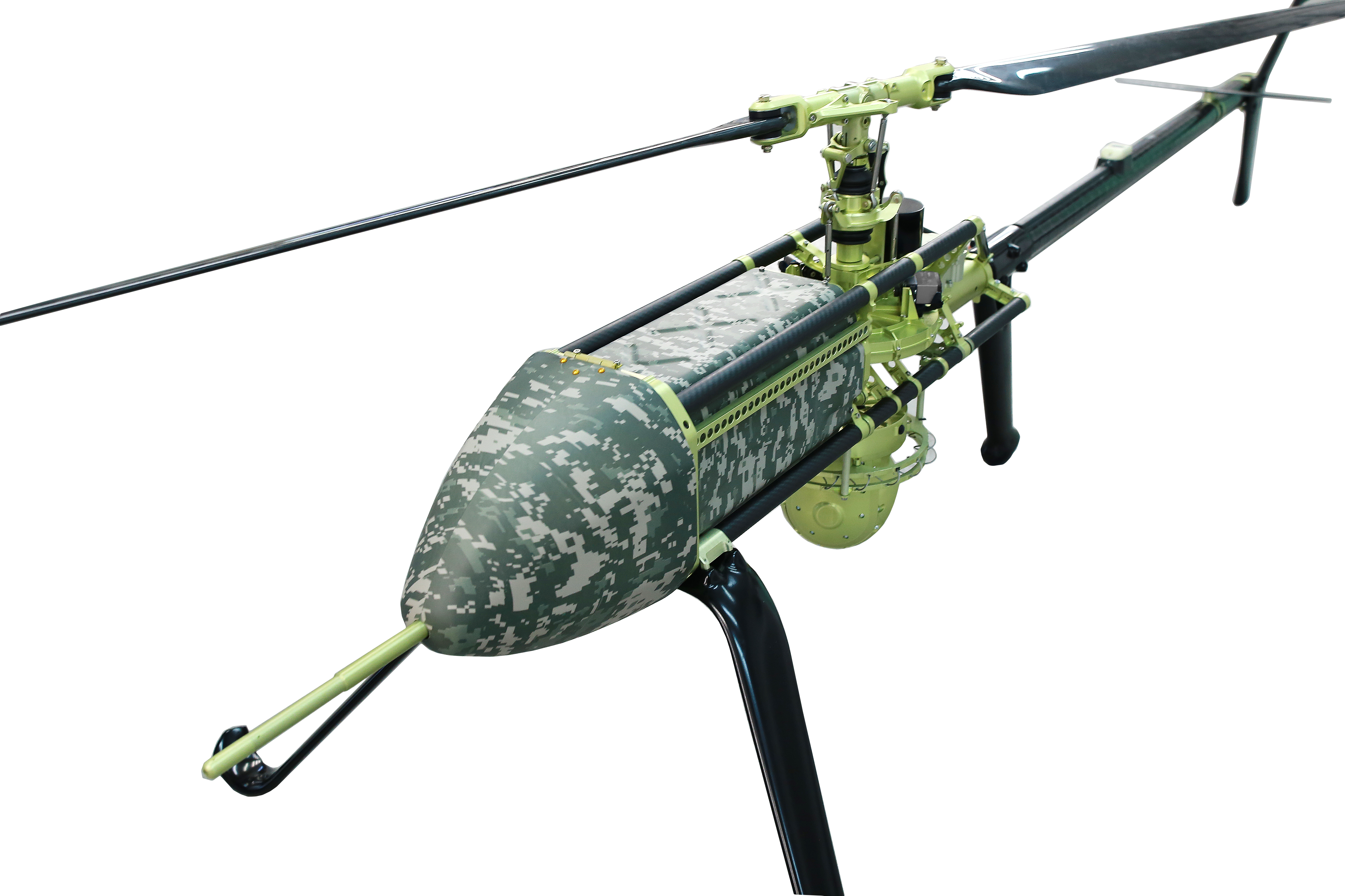
UAVOS has been selected by Bayanat, a provider of artificial intelligence-powered geospatial solutions, to deliver its unmanned aircraft system (UAS) for a variety of applications, including aerial photography and perimeter control. The UAS consists of two UVH 25EL unmanned autonomous helicopters powered by electric motors, a ground control station, and various sensor payloads — including a multispectral camera, lidar, and digital and thermal cameras.
The autonomous helicopter’s advanced capabilities of long endurance — up to 1.5-hours — along with its camera capabilities, enable the UVH 25EL to carry out accurate mapping within a radius of 67 km.
The UVH 25EL has a practical load weight of 5 kg. These capabilities enable high performance as well as maximum operational flexibility for applications such as coastal security, search and rescue, and advanced aerial photography missions.
UAVOS also provides full operational support, including training, and a fundamental review of the UAS’s possible uses.
Airbus Helicopters and the French Armament General Directorate (DGA) tested the unmanned aerial system (UAS) VSR700 for the first time in an operational configuration from a ship at sea.
The VSR700 performed 80 fully autonomous take-offs and landings from a civil vessel off the coast of Brittany in the west of France at the beginning of May.
In 2022, the autonomous take-off and landing capabilities of the VSR700 were tested from the same vessel using an optionally piloted vehicle based on a modified Guimbal Cabri G2 equipped with the autonomous take-off and landing (ATOL) system, developed for the VSR700. This time the test campaign took place with the SDAM demonstrator and fully validated the capabilities of the system as part of the Système de Drone Aérien pour la Marine study that was awarded to Airbus Helicopters and Naval Group in 2017.
Autonomous take-off and landing capabilities are a key asset of the VSR700 and are made possible with the use of the Airbus DeckFinder system. This enables autonomous launch and recovery of UAVs with an accuracy of 10cm-20cm during challenging operations in harsh environmental conditions, independently of GNSS/GPS and regardless of degraded visual conditions.
This test campaign follows two series of trials that were conducted with the DGA in late 2022 and early 2023, from the Levant Island test center located in the south of France. During these trials, the SDAM prototype demonstrated its ability to operate in a maritime environment.
The handling qualities of the aircraft were tested as well as the capabilities of the sensors (a maritime surveillance radar, an electro optical sensor, and an AIS receiver) alongside the mission system developed by Naval Group.
The next development steps will see the second VSR700 prototype perform its maiden flight ahead of flight testing onboard a French Navy FREMM during the second semester of this year.
The Sicura EG-1100 (left) and Anzen EG-1250 with Sky Power engines are being exhibited at AUVSI Xponential. (Photo: UAS Global Services)
German engine manufacturer Sky Power GmbH is presenting its UAV engines at this year’s AUVSI Xponential show in Atlanta, Georgia. Plus, new Sky Power customer UAS Global Services of Texas will present two new helicopters, which are powered by different engines from Sky Power.
UAS Global Services will introduce its Anzen EG-1250 helicopter at the show. The Anzen EG-1250 is a heavy-lift, long-range, multi-purpose Group 3 platform. The helicopter will significantly expand UAS Global Services’ service as well as operational support offerings. Basic specifications include a maximum takeoff weight of 250 pounds (113 kg), a maximum flight time of up to 6 hours, a payload capacity of 75 pounds (34 kg), a cruising speed of 65 kts, and all-weather day and night capability.
The “EG” in the Anzen EG-1250 designation stands for a dual engine configuration consisting of electric and internal combustion propulsion. The main engine is Sky Power’s SP-180 SRE Wankel engine, while the secondary engine is a NeuMotors 12030/5.5. This 30KW electric motor can power the aircraft or serve as a power amplifier in combination with the SP-180 SRE. In addition to the added power and safety provided by the two motors, the Anzen EG-1250 is autorotatable and offers an optional safety parachute system.
UAS-GS was contracted by Ireland-based UAV Evolution Ltd. to develop the dual-rotor platform. After more than 5 years of development, the versatile design allows for a variety of engine, payload and operational options. The platform flexibility allows the Anzen EG-1250 to support a wide range of customers in the marine, agricultural, oil and gas, utility, cargo transport, security and other application sectors.
UAS Global Service’s second helicopter is the Sicura EG-1100, which is the third generation of the internally developed single-rotor helicopter. This flight system has become the workhorse of the UAS Global Services fleet in recent years and is now available to external customers. Basic specifications include a maximum takeoff weight of 55 lbs (25 kg), a flight time of up to 3.5 hours using an internal combustion engine or a flight time of 1 hour in electric mode, a payload capacity of 15 lbs (7 kg), a cruise speed of 55 kts, and a takeoff wind speed of 25 kts.
The EG-1100 is available with both electric and internal combustion engines. The combustion engine is Sky Power’s powerful and efficient SP-110 TS ROS two-stroke engine, which has been specially tuned and modified to the flight system. The result is competitive flight performance characterized by stable performance under severe environmental conditions, exceptionally stable flight, and immediate flight response during imaging and LiDAR operations.
With the EG-1100’s considerable payload capacity, customers can implement various transportation tasks in one mission. Different sensor and camera systems can be integrated simultaneously in the Sicura EG-1100, enabling multiple data-acquisition applications in a single flight. This significantly increases the efficiency of the overall UAS mission and provides the customer with timely, cost-effective and high-quality results.
For more information, visit UAS Global Services at the AUVSI show in Atlanta, booth 2498 or visit Sky Power at booth 2641.
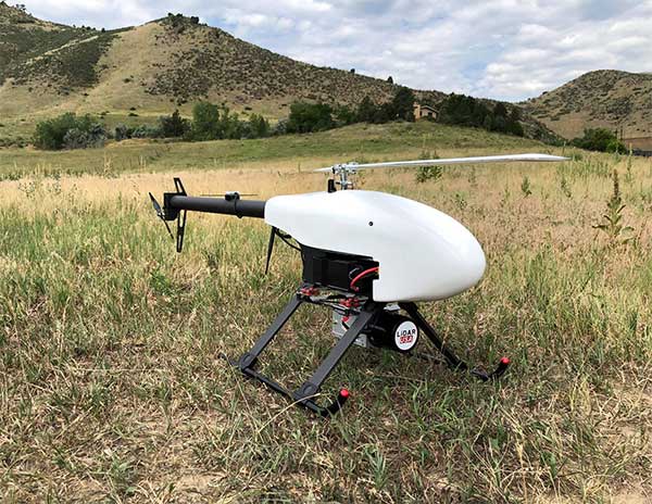
Lidar USA is partnering with Innoflight Technology, a manufacturer specializing in UAV systems for surveying, mapping and inspection.
As a result of the partnership, Lidar USA is offering the Galaxy 950 platform to carry any of its sensors while consistently providing flight times over 30 minutes.
Based in Somerville, Alabama, Lidar USA specializes in the design and integration of economical lidar sensors.
Innoflight and Lidar USA’s partnership is another step for both companies to offer turn-key solutions focused on quickly and safely acquiring high-quality data.
Innoflight designed the Galaxy 950 to simplify the flying aspect of remote sensing with UAVs. The helicopter includes a parachute, automatic takeoff and landing, and extended visual-line-of-sight capabilities to maximize productive time.
For corridor/electric utility line projects, the Galaxy 950 pairs well with the recently announced CL-90 by Teledyne Optech. As the first integration partner of the new compact lidar system, Lidar USA is offering maximum productivity at UAV flight ceilings while achieving improved canopy penetration and exceptional downward point density.
“Lidar USA and Innoflight Technology are both committed to customer success, and this partnership provides the whole package for lidar mapping solutions with UAV,” said Jeff Fagerman, CEO of Lidar USA. “Innoflight’s Galaxy 950 offers exceptional performance in safety, flight duration, and ease of use, which is what our customers need for their projects.”
The Galaxy 950 is now available from Lidar USA as an integrated package with any of their scanning systems.
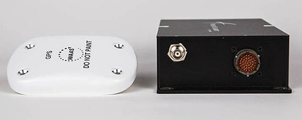
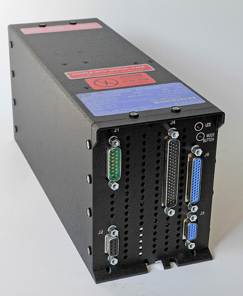
A FreeFlight Systems SBAS/GNSS receiver has been selected to provide ADS-B position source information as a part of an upcoming ADS-B modification and compliance program for the United States Air Force HH-60G helicopter fleet.
Strategic Enterprise Solutions Corp. (SESC) of Warner Robins, Georgia, was awarded the modification program, which includes installation of the 1203C SBAS/GNSS receiver and the AN/APX-119 Mode S Extended Squitter transponder with Mode 5 capability to provide a complete ADS-B Out solution for more than 100 helicopters.
An HH-60 Pave Hawk helicopter lands in Afghanistan; a UH-60 Blackhawk is in the background. (Photo: U.S. Air Force photo/Senior Airman Brian Ferguson)
The FreeFlight Systems 1203C SBAS/GNSS receiver is a certified, high-integrity position source in a compact, lightweight package that was designed to be modular and able to be integrated with various other avionics.
The 1203C pairs seamlessly with certified Mode S Extended Squitter transponders for a fully rule-compliant ADS-B Out system, FreeFlight said.
More than a war hawk. The primary mission of the HH-60G Pave Hawk helicopter is to conduct day or night personnel recovery operations into hostile environments to recover isolated personnel during war.
The HH-60G is also tasked to perform military operations other than war, including civil search and rescue, medical evacuation, disaster response, humanitarian assistance, security cooperation/aviation advisory, NASA space flight support, and rescue command and control.
The 1203C in service. With several hundred 1203Cs in service across airline transport, military, business aviation and rotorcraft platforms, these receivers are known for their high performance, ease of installation, operational reliability and longevity, FreeFlight said.
The 1203C SBAS/GNSS receiver and antenna (Photo: FreeFlight Systems)
The 1203C can also serve as the approved position source for select manufacturers of TAWS/FMS, RNP and other NextGen applications, and allows customers to take advantage of the operational and safety benefits provided by the NextGen airspace transformation without the need for extensive and costly avionics upgrades.
With the ADS-B mandate now only 17 months away, aircraft operators need to prioritize ADS-B installations.
Significant portions of today’s airline, business, and military aircraft fleet will remain in service long after 2020, and in many cases an STC’d retrofit solution comprising of a transponder upgrade and the addition of a dedicated SBAS/GNSS receiver like the 1203C is the simplest and most cost-effective way to achieve mandate compliance, FreeFlight said.
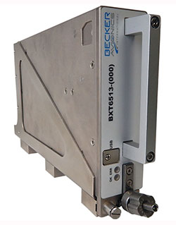
Becker Avionics has received certification for the its BXT65XX Mode S transponder, designed specifically for the rigorous flying environment characteristic of helicopter operations.
Paired with a FreeFlight Systems’ 1203C SBAS/GNSS sensor, the remote-mounted solutions provide helicopter operators a complete and cost-effective way to equip with ADS-B Out to meet the Jan. 1, 2020, mandate.
The system is a part of the company’s robust BXT65XX line of ADS-B Mode S transponders. Manufactured with a standard ARINC 429/743 output, this transponder easily integrates with the FreeFlight Systems Model 1203C SBAS/GNSS sensor for complete ADS-B Out compliance, the company said. It can also be installed either as dual installation for primary transponder interrogations or as single install for a dedicated ADS-B transmission.
The transponder can be installed on aircraft not equipped with a traffic collision avoidance system. Its enhanced privacy settings can disable both ADS-B and Mode S transmissions.
“We are pleased to announce this new milestone in our transponder product line,” said Forrest Colliver, Becker Avionics’ managing director. “This new system showcases how we tailor our compact, robust, and durable avionics to our clients’ requirements in order to provide the best solution for where and how they fly.”
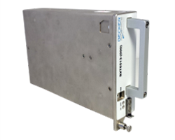
Becker Avionics Diversity Mode S Transponder with ADS-B certified.
Avionics technology provider Becker Avionics has received certification for the company’s BXT6500 family Mode S transponder, designed for the rigorous flying environment characteristic of helicopter operations.
Paired with a FreeFlight Systems’ 1203C SBAS/GNSS sensor, the remote-mounted solutions provide helicopter operators a complete and cost-effective way to equip with ADS-B Out for the upcoming Jan. 1, 2020, mandate.
The Becker BXT6500 family Mode S transponder is diversity-capable and available for installation on non-TCAS equipped aircraft. A non-diversity option is also available.
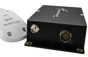
The FreeFlight SBAS/GNSS (WAAS/GPS) 1203C sensor.
In addition to providing clients with ADS-B compliance, the system features enhanced privacy settings that can disable both ADS-B and Mode S transmissions — a feature unique to the BXT6500 family.
“We are pleased to announce this new milestone in our transponder product line,” said Forrest Colliver, managing director. “This new system showcases how we tailor our compact, robust and durable avionics to our clients’ requirements in order to provide the best solution for where and how they fly.”
The system is a part of the company’s robust BXT6500 line of ADS-B Mode S transponders. Manufactured with a standard ARINC 429/743 output, this transponder easily integrates with the FreeFlight Systems Model 1203C SBAS/GNSS sensor for complete ADS-B Out compliance, and can be installed either as dual installation for primary transponder interrogations or as single install for a dedicated ADS-B transmission.
For more information, visit with Becker Avionics at booth C4935 and FreeFlight Systems at booth C1137 during HAI’s Heli-Expo happening this week in Las Vegas, Nevada.
The new Scout B-330 UAV in front of the Swiss Alps.
Swiss-based Aeroscout, a long-term partner of lidar manufacturer Riegl, has unveiled the Scout B-330 UAV helicopter.
The Scout B-330 is built with a payload capacity of up to 50 kg. (110 lbs), flight endurance of at least three hours, and the capability of flying at high altitudes (up to 3,000 meters above sea level) in a typical mission scenario. This includes a full autonomous take-off sequence, a mission flight at variable speed and a landing sequence.
The Scout B-330 is specifically designed for lidar-based powerline mapping missions. According to Aeroscout, it sets a benchmark in the long-endurance UAV class with its combination of flexibility, Swiss quality and competitive pricing.
“After one year of intense development, we are very excited to introduce our new Scout UAV system to the public,” said Christoph Eck, Aeroscout founder and CEO. “The reactions here at AUVSI are extremely positive and encouraging, we are very motivated for the serial production out of the system.”
The Scout B-330 pairs with Riegl airborne and unmanned lidar sensors such as the Riegl VP-1 Helicopter Pod, the Riegl VUX-1UAV lightweight UAV laser scanner and the Riegl VUX-1LR lightweight, long-range airborne laser scanner.
The B-330 was introduced at the AUVSI Xponential show held in Dallas in May. Those who missed that show can see it at the Commercial UAV Show in Las Vegas this October.
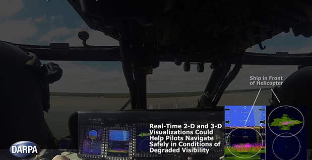
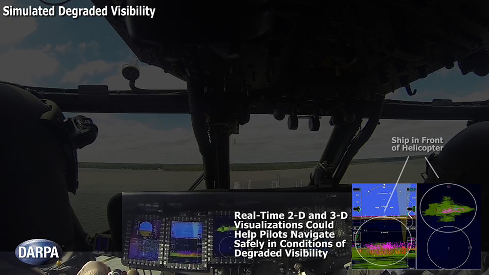
Degraded visibility — which encompasses diverse environmental conditions including severe weather, dust kicked up during takeoff and landing, and poor visual contrast among different parts of terrain — often puts both the safety and effectiveness of tactical helicopter operations at risk. Current sensor systems that can provide the necessary visualization through obscurants struggle with latency and are too large, heavy and power-intensive to comply with military rotary-wing operations.
The Defense Advanced Research Projects Agency‘s (DARPA’s) Multifunction RF (MFRF) program seeks to overcome these challenges and enhance the survivability and combat effectiveness of helicopters facing degraded visibility. The program aims to develop multifunction sensor technology that would enable sensor packages small, light and efficient enough for installation on existing and future helicopter designs. MFRF would enable pilots to:
Take off, fly and land safely in degraded and zero-visibility conditions
Avoid collisions with other aircraft, terrain and man-made obstacles (e.g. power lines)
Improve target detection, identification and engagement
MFRF completed successful flight demonstrations on a UH-60L Black Hawk combat helicopter (see video above) to demonstrate the Synthetic Vision Avionics Backbone (SVAB) technology portion of the program. The SVAB technology demonstration fused millimeter-wave radar with multiple terrain databases and onboard platform navigation to create high-resolution 2D and 3D visualizations of local environmental conditions.
Pilots referred to the visualizations in real time to distinguish terrain features (slope, roughness, landing suitability), detect objects in a landing zone, detect and avoid obstacles, and navigate in GPS-denied conditions. The software architecture of the SVAB also demonstrated plug-and-play sensor control and display.
“These successful tests take us closer to future cost-effective, ‘plug-and-play’ systems that would improve situational awareness and mission effectiveness for manned and unmanned platforms alike,” said Bruce Wallace, DARPA program manager.
Honeywell Aerospace’s LASEREF VI navigation system has been selected by Airbus Helicopters for its light helicopter platforms, the EC145 T2 and EC645 T2 family.
The LASEREF inertial reference unit (IRU) allows helicopter operators to always have an autonomous navigation source available in the absence of a GNSS and radio navigation. The capability is especially useful when navigating during a mission when the GNSS is unavailable due to terrain masking, limited satellite constellation availability, or unintentional or intentional jamming.
“LASEREF will provide Airbus Helicopters with exactly what they’re looking for — an always-available and highly reliable navigation system,” said Varant Panossian, customer business manager at Honeywell Aerospace. “When you’re in extreme situations, navigation is essential for everything from crew safety to completing critical missions.”
Designed for fixed-wing and rotary-wing applications, the LASEREF is a light, small IRU that delivers the highest reliability in the industry, according to Honeywell. Its integration with GPS prevents delays in information delivery and keeps operations running safely and efficiently even under harsh environments and demanding mission situations.
Northrop Grumman has been selected by AgustaWestland to supply the LCR-110 Inertial Reference System for the new AW609 TiltRotor aircraft.
Northrop Grumman Corporation has been selected by AgustaWestland, a Finmeccanica company, to provide flight-critical inertial instruments on the new AW609 TiltRotor aircraft undergoing civil certification through the Federal Aviation Administration.
The LCR-110 Inertial Reference System and the LCR‑300A Air Data Attitude Heading Reference System have been chosen as standard inertial navigation products for the advanced AW609 TiltRotor. The LCR‑110 features a high-performance, fiber-optic gyro-based inertial measurement unit and an advanced micro-electromechanical system (MEMS) triad accelerometer. The system offers hybrid navigation via GNSS data, in addition to aircraft autonomous integrity monitoring for GPS signal integration and integrity checks. These features are essential for precise Required Navigation Performance flight operations.
The LCR‑110 evolved from the successful, longstanding LCR‑100 product family that has been selected for numerous rotorcraft and fixed-wing platforms.
The systems were developed by Northrop Grumman Navigation and Maritime Systems Division’s subsidiary in Germany, Northrop Grumman LITEF.
“This suite of combined equipment provides critical flight control and navigation data to help the aircraft achieve required availability, precision and the highest levels of integrity,” said Eckehardt Keip, managing director for Northrop Grumman LITEF. “Our products enhance precision navigation operations, improve safety margins, save weight and volume, and provide attractive commercial advantages.”
The LCR‑300A is being introduced after several years of independent research and development. The system’s MEMS gyro provides advanced attitude heading reference system performance in combination with a magnetic sensing unit. It also features directional gyro mode, which minimizes magnetic compass errors.
The digital air data computer module, which is embedded in the LCR‑300A, was developed by Curtiss-Wright Corporation’s Defense Solutions division. It weighs less than 0.9 pound, yet contains the pneumatic sensors and processing electronics to generate the complete International Civil Aviation Organization air data parameter set. The module is designed using the latest high stability, low drift pressure transducer technologies, providing exceptional repeatability and reliability, Northrop Grumman said.
The twin engine, fly-by-wire AW609 TiltRotor combines the benefits of a helicopter and fixed-wing aircraft into one platform. The aircraft is a natural choice for civil and para-public roles, flying above adverse weather conditions at 25,000 feet in a comfortable and pressurised cabin at twice the speed and the range typical of helicopters.