Tag: Hemisphere GPS

  • The Remaking of Hemisphere

    The Remaking of Hemisphere

    When Beijing UniStrong Science & Technology Co. Ltd. in Beijing, China, acquired the Hemisphere GPS OEM business back in January 2013, and the significant Hemisphere GPS agriculture business went off on its own under the new AgJunction name, it’s possible that people may have gotten the impression that the OEM business might have been weakened by the break-up. (Read my column about the changes here.)

    There was word of a long-term supply agreement where the newly created Hemisphere GNSS was to still supply AgJunction with OEM receivers, but the OEM business now had to stand alone and fully support itself — perhaps a challenge for the teams in Scottsdale, Arizona, and Calgary, Alberta, that became part of the new company.

    After the first transition year in 2013, Jon Ladd, chairman of the new Hemisphere GNSS board of directors and former CEO of Novatel, along with the other Hemisphere board members, decided to hire Chuck Joseph in January 2014. Prior to joining Hemisphere GNSS, Chuck Joseph was president and CEO of an energy technology company, and he was also senior VP and general manager of a tactile feedback technology company focused on GPS centric mobile and industrial applications. But the key experience that may have brought Chuck to Hemisphere GNSS was probably when he was corporate VP of marketing and sales at Magellan Corporation and executive VP and general manager of Trimble.

    I talked at length with Chuck Joseph and his team recently about how things have gone since he joined Hemisphere and the changes that have brought them to some new product launches now being announced.

    Chuck reviewed some of his experiences from Trimble — a time when even Trimble was struggling in the early days and he helped with a reorganization that pulled them back from some big losses around the time of the first Gulf War — and how that has helped him at Hemisphere GNSS. Focusing on the consolidation of products and markets that work, and moving away from things that don’t work as well — this is always a key element for any recovery.

    As a part of Hemisphere GPS, the OEM business may have been at a major disadvantage when it was tied so tightly to the success of its own agriculture business — all of its receiver-development efforts were focused on agriculture applications and on whatever worked best for agricultural customers. So the rest of the company’s efforts to create a self-sustaining OEM business all came in second. But with some of the brightest innovators and developers in the GNSS OEM business, Hemisphere had a wealth of experience and a store of existing Intellectual Property (IP) ready to open up when the opportunity came around as a part of the new organization.

    Chuck likes to talk about Hemisphere GNSS being a start-up inside a reinvention” — a phrase that describes how life may have been re-energized and changed for the people in the new company. With UniStrong support, there was no need to seek other outside external investment for company expansion and sustainment, so all management effort could be initially focused on the re-engineering effort. Staff working groups were formed that were able to brainstorm and come up with new concepts, explore how they fit with their market and existing customers, and over time create viable approaches, turn them into strong business cases and then go find the support they deserved. “Disruptive” market ideas were at the forefront — ideas/products/services that would allow Hemisphere to make advances in the OEM market that would offset the strengths of the competition and allow them to succeed. Closer partnering with new and existing customers to provide improved value was a major leading concept.

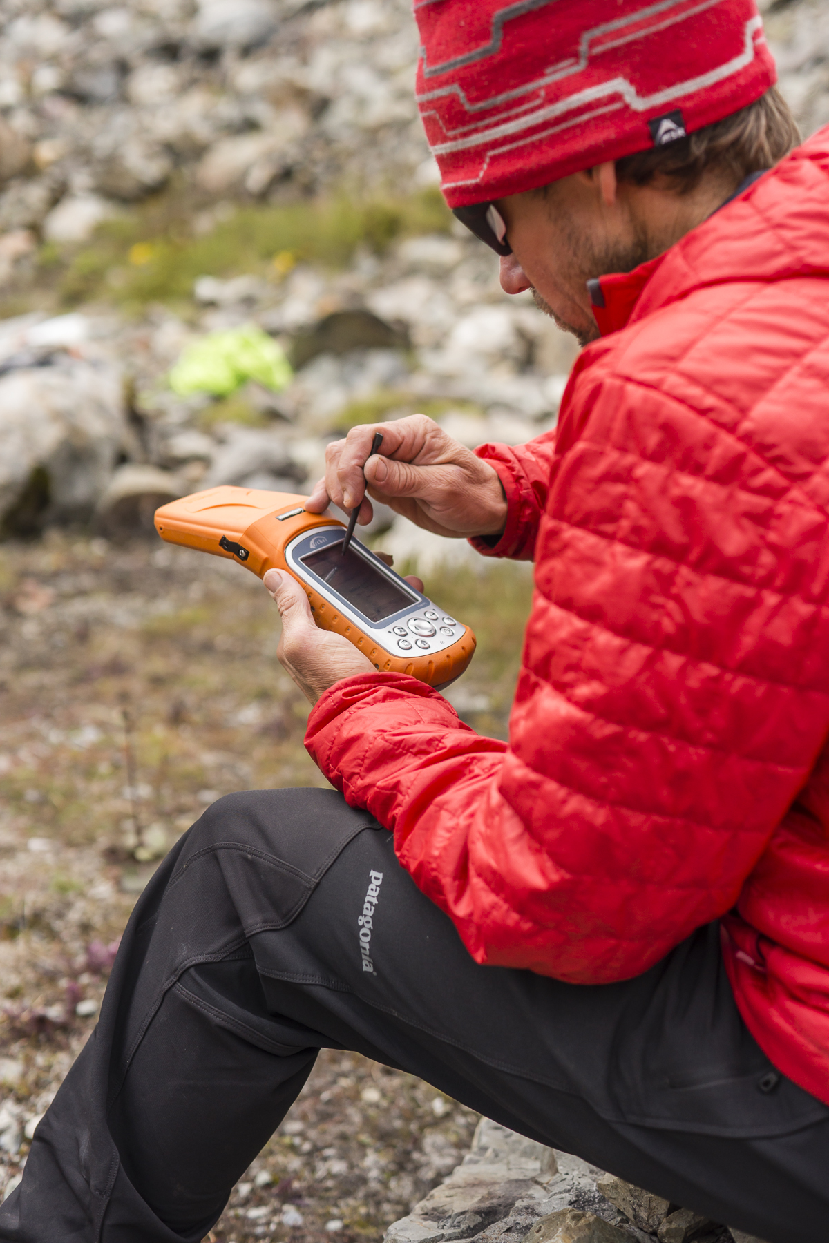
    The first product to hit the market from the new Hemisphere GNSS process came out of a 10-person team who set out to re-engineer and improve Hemisphere RTK — the release of Athena was announced at the beginning of May. As the announcement goes, this new RTK “excels in virtually every environment where high-accuracy GNSS receivers can be used.”

    AthenaComparisonSummary-Hemisphere-W
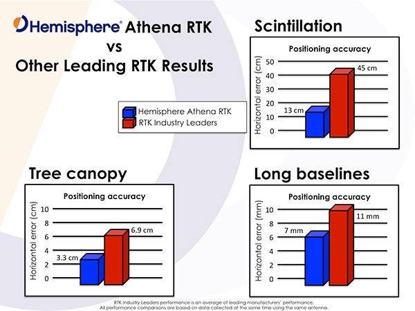
Customers have already validated Athena’s performance in long baseline, in open-sky environments, under heavy canopy, and in geographic locations with significant scintillation. Key features include:

    • Initialization in less than 15 seconds at better than 99.9% reliability
    • Robustness under the most aggressive of geographic and landscape environments
    • Industry-leading position stability for long baseline applications, with position quality often exceeding the performance of the best-of-breed RTK systems on the market
    • Sustained accuracy within GNSS scintillation-affected areas

    Testimonials in the Athena release support Hemisphere’s claims — from independent testing (Andy Carbognin, Vecto Geomatics), marine construction and hydrographic survey (Cable Arm), land survey and machine control (Carlson Software) and agriculture precision steering (Novariant).

    And Hemisphere GNSS has more new products coming — the company just announced its Atlas GNSS global correction service on June 15. Hemisphere is marketing Atlas using a “disruptive” approach, intended to not only provide end customers with the best value and best performance global correction service available today, but also to support the sales channel that the customers buy through. The sales angle chosen is to allow the sales channel to actually sell and bundle the Atlas service directly to the customer and make money from the sale of the service. This approach is not currently used by other correction service distributors, who tend to have manufacturers and customers deal with them directly for service, sales and support.

    Chart: Hemisphere GNSS

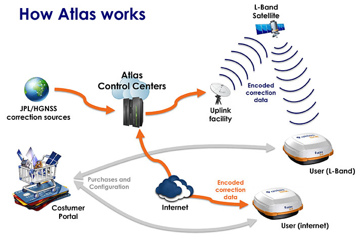
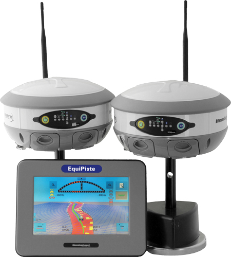
    Hemisphere GNSS put together a team of seasoned developers to build Atlas that between them have already generated a huge amount of IP around corrections technology. Together, they have now developed the Atlas GNSS correction service, available via L-Band satellite broadcast and over the Internet, which uses the very latest technologies to deliver a correction service that matches or exceeds existing competitive system performance:

    • Positioning accuracy: Atlas provides competitive positioning accuracies down to 2 cm RMS in certain applications, often exceeding competitive systems’ capabilities
    • Positioning sustainability: Position quality maintenance in the absence of correction signals, using Hemisphere’s Tracer technology.
    • Convergence time: Industry-leading convergence times of 10-40 minutes.
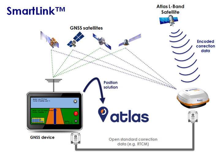
    • Receiver-agnostic capability: Atlas is the most receiver-agnostic positioning system available. SmartLink technology allows an AtlasLink antenna to be used as an Atlas signal extension for any GNSS system which uses open communication standards.
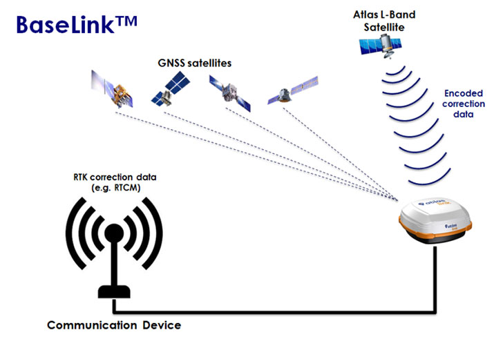
    • Network RTK augmentation: BaseLink technology allows Atlas-capable receivers to self-calibrate, self-survey, and automatically manage the transmission of RTK corrections to augment or extend established or new GNSS reference networks in areas of poor Internet connectivity.
    • Atlas subscriptions: Subscriptions are now available for a range of Hemisphere GNSS’s multi-frequency, RTK-capable products — AtlasLink, R330u, V320, and VS330u — and will soon be available via the Atlas web portal and from a number of channel partners and OEMs such as Carlson Software.

    Available Hemisphere GNSS Atlas service levels:

    Service Level Position Accuracy
    H100 100 cm 95% (50 cm RMS)
    H30 30 cm 95% (15 cm RMS)
    H10 8 cm 95% (4 cm RMS)

    The provision of “agnostic” corrections via the SmartLink service is a new twist that allows customers to buy the best correction service they choose, rather than being tied to a particular receiver manufacturer and/or their corrections services supplier. Using the Hemisphere GNSS AtlasLink smart antenna, corrections can be supplied over a standard interface to any make of GNSS receiver, provided it has an interface that is compatible with “open-standard” correction data, such as RTCM data format. It remains to be seen if this “receiver-agnostic” approach to corrections supply changes the way that PPP and other correction services are supplied across the industry.

    ATLAS-Launch-smartlink-W

    The service can also be used to set up base stations to transmit corrections to an existing network using the BaseLink service option, which Hemisphere is also making available.

    ATLAS-Launch-baselink-W

    Meanwhile, back at UniStrong in China, Xinping Guo, president and CEO of UniStrong — or ‘XP’ as he is known to the Hemisphere GNSS team — has been actively seeking further funding through potential additional stock offerings, not only to maintain support for Hemisphere, but also to buy additional companies in China. While Hemisphere GNSS has ramped up revenue since being purchased by UniStrong and is on its way to a record year in 2015, it is clearly doing more things and announcing more new products and initiatives than its normal revenue ramp would solely support. So, just as in the case of a start up, UniStrong is supplying supplemental resources to support this very fast track growth.

    Coordination of activities across the UniStrong and Hemisphere GNSS companies continues as the Hemisphere GNSS company/brand relaunch rolls out during the second half of this year. Product designs will flow back and forth across the group, too, with Hemisphere GNSS software used in UniStrong products, and BeiDou capability going into Hemisphere GNSS fourth-generation chips. The collaboration of the UniStrong and Hemisphere product development teams is producing products unique to each market place, to be sold and supported by the respective sales, support and marketing teams, helping both companies. While UniStrong may be able to claim to be leading in China in the single-frequency product (GIS, etc.) market, it’s also easy to see that bringing Hemisphere GNSS multi-frequency capability into China could also improve its domestic market share.

    So, it’s been a good start to the reshaping of Hemisphere GNSS as a company, its capabilities and its approach to its chosen markets. Let’s see how this roll-out and the anticipated growth continue through the rest of the year, and we’ll check in again in detail with them in the fall. Many thanks to Chuck Joseph and his team for this inside look into what’s going on in the remaking of Hemisphere GNSS.

    Tony Murfin
    GNSS Aerospace


  • Juniper Systems’ Archer Field PC Records Elevation of Remote Himalayan Peak

    Juniper Systems’ Archer Field PC Records Elevation of Remote Himalayan Peak

    Juniper_Archer_on_Mountain
    Photo credit: Mark Fisher at www.fishercreative.com, Instagram: @fishercreative; via Juniper.

    Juniper Systems’ Archer Field PC has beenused to record the elevation of a never-before-climbed peak in the remote Myanmar Himalaya. The peak, Mount Gamlang Razi, has historically been known as the second highest peak in Southeast Asia, but a joint American-Myanmar-led expedition set out on a mission last September to hopefully prove that it is in fact the tallest. Read the whole story on Juniper Systems’ blog.

    Standing at a reported 5,881 meters tall, Mount Hkakabo Razi has long been known as Southeast Asia’s highest peak. In recent years, however, the legitimacy of the elevation of Hkakabo Razi has come into question. Current digital analysis suggests that initial surveys of Mount Hkakabo Razi were overstated and its actual elevation is as much as 100 meters lower than originally believed. At the same time, digital analysis suggests that virgin-peak Gamlang Razi may in fact be the taller peak. This controversy prompted Idaho resident and experienced climber Andy Tyson to lead an American-Myanmar expedition team on a three-week approach through 150 miles of cobra-riddled, mosquito-infested jungle, and from there up to the peak of Gamlang Razi to measure its elevation in person.

    Tyson needed a device that could accurately record the elevation at the summit, while being able to withstand the extreme conditions of the hot, wet jungle and the frozen mountaintop. With this in mind, Tyson requested from Juniper Systems a top-of-the-line rugged handheld. In response, Juniper Systems provided the team with an Archer Field PC with Hemisphere GPS XF101 receiver, along with training to record the GPS data they needed.

    Setting up the Archer Field PC to collect GPS data. Photo credit: Mark Fisher at http://www.fishercreative.com. Instagram: @fishercreative
    Setting up the Archer Field PC to collect GPS data. Photo credit: Mark Fisher at http://www.fishercreative.com/Instagram: @fishercreative/via Juniper.

    After a 35-day journey, Tyson and the team successfully summited Gamlang Razi, with the Archer Field PC in hand. After collecting GPS data at the top, the data was sent via satellite phone to Juniper Systems for analysis. After post-processing the data against terrestrial base stations in Lhasa, Tibet, and confirming the results with Effigis in Montreal, Canada, Juniper Systems concluded that the elevation of Gamlang Razi was 5,870 meters, ±2 meters. This suggests that Gamlang Razi is taller than nearby Hkakabo Razi by approximately 112 meters and should be considered Southeast Asia’s new highest peak.

    However, there are many — particularly natives to Myanmar — who are not ready to accept changes to Hkakabo Razi’s original elevation measurement. This was made apparent in a letter Myanmar’s president, Thein Sein, wrote to Tyson and the team after their successful summit, congratulating them for summiting Southeast Asia’s second-tallest peak.

    Tyson remains firm in his assertion that Gamlang Razi is the country’s highest peak, but some have suggested that the debate may not be over until someone actually climbs Hkakabo Razi and measures it in person. Juniper Systems said they have a handheld for the job, should that time come.

    The expedition team. Photo credit: Mark Fisher at http://www.fishercreative.com. Instagram: @fishercreative
    The expedition team. Photo credit: Mark Fisher at http://www.fishercreative.com. Instagram: @fishercreative/via Juniper.
  • Nightmare on GIS Street: GNSS Accuracy, Datums and Geospatial Data

    Sponsored by: Hemisphere
    Broadcast Date: Thursday, June 20, 2013
    Moderator: Eric Gakstatter, Survey Scene Newsletter Editor
    Speakers: Kevin Kelly, Geodesist, ESRI, Inc.; Craig Greenwald, Technical Director, GeoMobile Innovations; Michael L. Dennis, RLS, PE, Geodesist, NOAA

    A look at the challenge of dealing with horizontal datums in your GIS. We are moving into a new era in dealing with datum transformations. Geodata 2.0 is coming, and it can create big headaches when attempting to combine disparate geospatial databases. Sensors such as GPS receivers, remote sensing imagery, and 3D scanning provide much more accurate data, setting up a collision with outdated and mismatched legacy horizontal datums.

  • Hemisphere GPS Moves Calgary Office

    The Hemisphere GPS Calgary office is relocating to a new address, effective May 8.

    As of that date, the location on 9th Street will be replaced by this address:

    150 – 6712 Fisher Street SE, Calgary, AB T2H 2A7

  • Hemisphere GPS Sells Precision Business to Chinese UniStrong

    On January 31, Hemisphere GNSS Inc., a subsidiary of Beijing UniStrong Science & Technology Co. Ltd., purchased the Precision Products business and related GNSS technology and intellectual property from Hemisphere GPS Inc. for $15 million US. In a related press release, Hemisphere GPS Inc. has announced the intention to change its company name to AgJunction.

    As part of the transaction, Hemisphere GNSS acquired all of the high-precision GNSS product lines, all related intellectual property rights and the Hemisphere GPS trademarks and brands. The Precision Products segment generated revenues of approximately $13.3 million in 2012 serving marine, land survey, construction, mapping, and OEM segments.

    Hemisphere GNSS will operate its business headquarters out of Scottsdale, Arizona, and will maintain its operations in Calgary, Alberta, Canada.

    Phil Gabriel has been appointed president of Hemisphere GNSS Inc. and will also serve as a board member. Gabriel has more than 15 years of experience with Hemisphere GPS, serving for the past six years as the vice president and general manager of the Precision Products business.  “We are truly excited about our future growth prospects as a fully focused GNSS products and technology provider,” Gabriel said. “I would like to assure all our global distribution partners, suppliers and customers that it remains business as usual as we take our first steps forward with the strong backing of UniStrong.”

    With this acquisition, UniStrong is expanding its capabilities in the high-precision GNSS business and also expects to promote commercial applications of China’s BeiDou Navigation System. UniStrong is listed on the Shenzhen Stock Exchange under ticker 002383.

    Business analysts have reported in China that this is the first acquisition of an internationally renowned enterprise initiated by a domestic enterprise in China’s satellite navigation industry and represents an important milestone in the development of the industry. “The acquisition will create an international route enabling UniStrong to expand its global business outlook, enhance our ability to attract international talent, and lay the foundation for international growth and profitability,” stated Xingping Guo, president and CEO of UniStrong.

    As part of the agreement, Hemisphere GNSS and AgJunction have formed a strategic alliance and a collaborative business relationship covering supply chain management, customer support, technology development and cross-licensing. “Having already established a relationship with UniStrong as one of our resellers made our new alliance a win-win for both parties,” said Rick Heiniger, president and CEO of AgJunction. “I am very pleased to be working together in this close technology-sharing relationship.”

    Hemisphere GNSS’s newly appointed board of directors brings additional GNSS industry experience to the company. The board is chaired by Jonathan W. Ladd, former president and CEO of NovAtel Inc. Also joining the board is Werner Gartner, former executive vice president and CFO of NovAtel Inc.

    “Hemisphere’s talented team will leverage its core GNSS capabilities and product marketing knowledge with UniStrong’s high quality, low cost GNSS product design and development resources,” said Ladd. “Hemisphere’s existing and future customers and partners will most certainly benefit from the resulting rapid, cost-effective product innovation across multiple product lines.”

    Beijing UniStrong is focused on GNSS industry, with R&D, production, engineering, sales and service facilities. Its technical solutions and products cover GPS/GLONASS/COMPASS receivers, multi-system navigation and positioning, high-accuracy surveying, GNSS data post-processing, and system integration.

    The re-branding of Hemisphere GPS as AgJunction is an integral part of the strategic re-focusing of the company’s resources on precision agriculture, and part of the restructuring initiated in September 2012. The company maintains ownership of its key patents and leading agricultural brands including AgJunction, Outback Guidance, and Satloc.

  • Hemisphere GPS Cuts Non-Agriculture Business

    Hemisphere GPS, Inc., has announced a new corporate strategy that focuses exclusively on the agriculture business. The company, which appointed Rick Heiniger chief executive in September, said it expects to save $7 million annually from the restructuring. The workforce will be reduced from 273 to about 170, and the headquarters will be moved from Calgary, Alberta, Canada, to Hiawatha, Kansas, where Hemisphere GPS’s agricultural operations are located.

    Hemisphere GPS said diversification into marine, construction, and other industries had increased costs, absorbed cash, and distracted management focus from its core agriculture business. The agriculture business contributed 81 percent of the company’s revenue in the first nine months of 2012. Hemisphere’s agriculture products include the Outback line, OEM boards and antennas, and precision agriculture systems.

    The company has hired an investment banking firm to pursue strategic alternatives for the Precision Products (non-agriculture) business. “Given the agricultural focus of the Company, the board believes that the Precision Products business can grow more quickly with another organization that is more strategically aligned,” the company stated.

    “The agricultural industry is entering a period of exceptional opportunity. We’re in the early stages of transformational adoption of high-definition production practices,” said Hemisphere GPS’ new CEO, Rick Heiniger. “We are a data driven society, and agriculture is no different. Agronomic specialized data-management and cloud information services, combined with a new generation of connected devices and machines, will not only enable emerging technologies, but will simplify existing workflows and deliver productivity gains for the industry. We will be wholly focused on the essential core technologies while at the same time assisting the industry in its adoption.”

  • Hemisphere GPS Introduces Outback MAX with ConnX


    Hemisphere GPS has introduced Outback MAX with Outback ConnX — what it calls its “next-generation Outback Guidance system that redefines simplicity in precision farming.” Working seamlessly with Outback eDriveX with eTurns, the Outback MAX integrated display terminal provides a full array of features including section and variable rate control, Eclipse L1/L2 GPS and GLONASS guidance, and video support for up to four monitoring cameras, the company said.

    Outback MAX also provides wireless connectivity via the Outback ConnX data management system to deliver real-time data access and management that is imperative for modern farmers. ConnX provides seamless data transfer between the Outback MAX terminal, office, and service providers ensuring efficient, accurate decision making and farming operations. ConnX can automatically import and export data, engage customer service with remote control capability, and simplify connection to RTK correctors. ConnX is compatible with popular data platforms including AgJunction, AgVerdict, NutriScription HD, OptiGro, and Precision.Ag.

    “Hemisphere GPS has established a new level of innovation with Outback MAX that will substantially improve the accessibility and effectiveness of automated guidance and application control,” said Kip Pendleton, senior vice president and general manager of Agriculture at Hemisphere GPS. “The highly functional yet simple design of Outback MAX combined with the seamless connectivity between the field, office, and service providers greatly enhance the value that farmers can realize from precision farming techniques.”

    Building on the functionality of company’s successful, the feature-rich Outback S3, the Outback MAX adds a host of new features: simplicity in design and operation, a powerful mapping engine, excellent screen clarity, seamless connectivity, and a rugged design that can operate in rough environments — features that are critical to achieving the benefits of precision farming. Outback MAX incorporates the ability to create shortcuts and favorites for the most commonly used tasks, facilitating a short learning curve with simple access to important features, getting farmers up and running quickly, Hemisphere GPS said.


  • Hemisphere GPS at the ESRI International Users Conference

    GPS World magazine interviews at the ESRI International User Conference 2012, talking with Garry Hurkens of Hemisphere GPS.

  • Hemisphere GPS Awarded New Patents for Machine Control

    Hemisphere GPS, a leading innovator and manufacturer of advanced GNSS products, continues to expand its intellectual property portfolio with newly awarded patents. These patents represent the latest advancements in adaptive machine control and GNSS solutions, the company said.

    The Adaptive Machine Control System and Method patent describes the sophisticated adaptive control methods used to guide vehicles and provide accurate and efficient coverage. The system is comprised of a machine controller, GNSS guidance system, and software and is most commonly used in precision farming. From pre-planned guidance patterns the system provides the ideal pattern adjustments for guidance and automated steering taking into account a variety of conditions and user inputs including path, boundary or terrain irregularities, and minimum turning radius. In addition, the system provides optimal, automated turns and spray nozzle control. As a result, farmers complete their fieldwork with greater accuracy and efficiency as well as improve their yields and reduce their input expenses. The patent supports current products and new developments within Hemisphere GPS’ precision farming product line including Outback Guidance branded products.

    Hemisphere GPS was awarded seven other patents in 2012 that include advanced GNSS solutions for antenna design, an application specific integrated circuit (ASIC), multiple antenna control system, tracking of fixed and slow-moving structures, augmentation of differential corrections, antenna alignment and monitoring system, and vehicle guidance control.

    "Hemisphere GPS’ commitment to innovation has generated over 75 pending and issued patents,” said Mike Whitehead, chief scientist at Hemisphere GPS. "Through these inventions and sophisticated new technology, we continuously enhance capability and performance of our positioning, guidance, and machine control solutions in the marketplace.”

  • Compact Modules for RTK GNSS

    Hemisphere GPS announces the Eclipse P300 and Eclipse P301 OEM modules — its next-generation high‑performance compact modules for RTK GNSS applications. Based on new Hemisphere GPS multi-function application firmware and Eclipse GNSS multi‑constellation technology, P300 and P301 provide the ability for tracking commercially available GNSS signals for precise positioning.

    P300 is a drop-in board replacement for Hemisphere GPS’ successful Crescent L1 board as well as the first‑generation miniEclipse P200 GPS-only OEM board. P301 is the company’s 20‑pin OEM module configured as a drop-in replacement for a different industry standard interface. Eclipse P300 and P301 improve GNSS positioning performance, particularly with RTK applications, through Hemisphere GPS’ patent-pending SureTrack technology. Benefits include extended and more robust RTK solutions as the rover RTK receiver will process all available signals even if they are not common with the base receiver. RTK solutions are therefore better maintained in challenging environments, with baselines of up to 50 km, and reacquisition times are improved resulting in more robust overall performance, the company said.

    P300 and P301 are designed for OEM system integrators who demand the highest level of multi-frequency positioning, accuracy, fast initialization time, and GNSS RTK solutions. Hemisphere GPS’ miniEclipse series includes a single frequency L1 GPS + L1 GLONASS model named P202. Both series are designed for developing integrated high-precision and control applications for geomatics, survey, machine control, and unmanned vehicle solutions.

    “P300, P301, and P202 all improve upon our already successful miniEclipse OEM modules adding GNSS support to our most compact modules for excellent accuracy and affordability,” said Phil Gabriel, vice president and general manager, Precision Products, for Hemisphere GPS. “System integrators have a wider range of Hemisphere GPS solutions from which to choose to develop world‑class high‑precision products.”

    Measuring 71 mm long and 41 mm wide, miniEclipse allows for easy integration, especially for integrators who are accustomed to Hemisphere GPS’ Crescent and miniEclipse OEM module performance and footprint.

    All miniEclipse modules are available through the Hemisphere GPS Precision Products global dealer network.

  • Snow Grooming Management System

    Snow Grooming Management System

    EquiPiste-with-S320

    Hemisphere GPS has announced the EquiPiste integrated snow grooming management system. EquiPiste provides visual guidance, snow depth status, and event logging for snow grooming operators, mountain managers and snow road operations. Ski resorts benefit from improved grooming quality and productivity, optimal snow making decisions and distribution, as well as more predictable and preventative snow cat maintenance, according to Hemisphere GPS.

    Snow grooming operations are tasked with creating quality snow conditions for ski trails or pistes, as they are referred to in the industry. Designed with an integrated touchscreen terminal and Crescent GPS, Hemisphere GPS’ EquiPiste graphically displays to the operator the areas groomed, boundaries, assets, points of interest, and hazards. Through the guidance cues, operators increase their efficiency and quality of work by avoiding overlaps and skips in grooming, Hemisphere GPS said. Areas that need attention such as thin snow pack and winch anchors can be flagged with meta-data so operators can easily navigate back at any time, even in low visibility. Pathways can be mapped and re-used for training novice operators or for repeatedly navigating snow roads. Operation managers benefit from reviewing the job files from each machine to determine variable costs, performance and maintenance tracking, the company said. As well, data can be mapped within Google Earth and used for generating daily grooming or road maintenance reports for customers.

    Many ski resorts also spend a substantial amount of their budget on snow making activities. When combined with Hemisphere GPS’ survey grade Eclipse GNSS technology, EquiPiste displays and records real-time snow depth measurements and maps, the company said. The snow depth data improves the efficiency and quality of managing the snow levels. The depth data helps indicate where and when to make snow, it alerts the operator to thin snow pack, where to redistribute snow as well as how to identically recreate (day to day and year to year) downhill race courses. Analysis of the snow depth data enables more optimized snow management.