Hexagon AB, which offers digital-reality solutions combining sensor, software and autonomous technologies, will integrate AVVIR’s artificial-intelligence-powered technology stack into its portfolio of solutions that address challenges of the construction lifecycle.
Since 2017, AVVIR has enabled intelligent, data-driven job sites that empower commercial, infrastructure and industrial construction professionals to reliably and safely deliver on schedule and within budget, Hexagon stated in a press release.
AVVIR’s reality-analysis platform is focused on building information modeling (BIM). It is designed to improve project workflows, schedules and outcomes by leveraging onsite reality-capture data, enriched BIM models and artificial intelligence. The solution gives construction teams control with automated schedule tracking, cost and earned value analysis, installation issue detection, and an updated BIM with as-built conditions.
Ola Rollén to be proposed as chairman of the board
Paolo Guglielmini, Hexagon
Hexagon AB has announced that Paolo Guglielmini will succeed Ola Rollén as president and CEO of Hexagon AB, effective Dec. 31.
Gun Nilsson has decided to step down as CEO for Hexagon’s principal shareholder MSAB on Oct. 1 and leave her position as chairman of Hexagon AB at the Annual General Meeting (AGM) 2023. MSAB, in consultation with Hexagon’s nomination committee, will propose Ola Rollén as new chairman of the board at the AGM 2023.
Guglielmini, currently Hexagon’s chief operating officer (COO) and president of Hexagon’s Manufacturing Intelligence (MI) division, has served in key roles since joining Hexagon in 2010, from strategy and business development to M&A and general management. He has been instrumental in expanding MI’s focus towards software-centric quality data solutions, and with his team driving the business towards all-time-high performance in 2021. Before joining Hexagon, Guglielmini held positions at CERN, the European Organization for Nuclear Research in Switzerland and Accenture. He holds a master of science in engineering and master of business administration from IMD.
”I’m happy that we have found an internal solution for my succession, which will bring long-term stability and continuity, but at the same time needed rejuvenation as we prepare this amazing company for the next big leap strategically,” Rollén said. “I have preoccupied myself with the well-being of Hexagon 24/7 for the last 22 years, and it’s a true privilege to be able to continue to follow the company’s successful development as chairman.”
“I’m honored by the opportunity to build upon the legacy that Ola and our team have created over the past two decades, and excited to lead Hexagon into the future,” Guglielmini said. “We are very well positioned to capitalize on the vast opportunities ahead, combining software, sensors and autonomous technologies to create sustainable value for our stakeholders.”
At the same time, the following organizational changes will be made:
Josh (Joshua) Weiss, currently COO of Hexagon Geosystems, will succeed Guglielmini as president for Hexagon Manufacturing Intelligence, effective July 1. Weiss has served in multiple leadership roles since joining Hexagon in 2015, from his most recent role to the president of Geosystems’ mining and heavy construction businesses. Weiss will report to Hexagon’s president and CEO and be a part of the Executive Management Team.
Michael Ritter, currently president of Hexagon Autonomy & Positioning, will assume a new senior role overseeing Hexagon’s Autonomy & Positioning, Mining and Agriculture divisions, effective immediately. In this role, Ritter will be responsible for leading the strategy of the businesses, to accelerate synergies and strengthening the solutions portfolio for Hexagon’s customers. Ritter will continue reporting to Hexagon’s president and CEO and be a part of the executive management team.
Maria Luthström, currently head of Sustainability and Investor Relations for Hexagon, will succeed Ritter as president of Hexagon Autonomy & Positioning, effective Oct. 1. Luthström joined Hexagon in 2015 and has been instrumental in expanding the company’s strategy and environmental, social and governance agenda, strengthening Hexagon’s culture and increasing shareholder value. Luthström will report to Michael Ritter.
Because of circumstances following Russia’s invasion of Ukraine, Hexagon AB has made the decision to freeze all business activities in Russia. Hexagon AB is a global leader in digital reality solutions combining sensor, software and autonomous technologies.
Hexagon already suspended all exports of hardware and software licenses to Russia and is now taking further steps to adapt to the current business situation.
Given the uncertainty of the outlook, these steps are constantly under review and will be adjusted if the situation changes.
About 2 percent of Hexagon’s annual turnover can be attributed to business in Russia, with approximately 200 people employed in the country.
Hexagon AB, a provider of digital reality solutions combining sensor, software and autonomous technologies, has acquired ETQ, a provider of SaaS-based quality management system (QMS), environment, health and safety (EHS) and compliance management software.
Customers have long relied on ETQ’s QMS solution, ETQ Reliance, which provides the data backbone for automating the collection and delivery of manufacturing quality control data, non-conformance reports, customer feedback and more, providing an enterprise view of quality management across a product’s lifecycle. Its portfolio of applications comes with out-of-the-box functionality and no-code configurability, enabling customers to tailor the solution to their needs and optimize business processes to achieve their quality, safety and environmental goals.
ETQ’s data management capabilities, driven by machine learning and artificial intelligence, make quality data fully actionable and available further upstream. In addition to reducing defects, scrap, rework, and recalls, it enables an autonomous feedback loop, digital information trail and virtuous cycle of continuous improvement.
Founded in 1992 and with a staff of 185, ETQ is headquartered in Massachusetts with additional offices in Arizona and Dublin, Ireland. It operates in industries including the life sciences, healthcare, heavy manufacturing, electronics, food and beverage, heavy process, and automotive. ETQ will operate as part of Hexagon’s Manufacturing Intelligence division. Completion of the transaction is subject to regulatory approvals and other customary conditions, which are expected to be fully completed by early in the second quarter 2022.
Hexagon AB has made the following organizational changes, effective immediately:
Paolo Guglielmini, currently president of the Hexagon’s Manufacturing Intelligence (MI) division, has been appointed chief operating officer (COO) for Hexagon AB.
In his new role, Guglielmini will support Hexagon President and CEO Ola Rollén to develop and implement Hexagon’s strategy, as well as overseeing the operations of the company’s divisions. Guglielmini will retain his current role as President for the MI division until a successor has been appointed.
Guglielmini has been leading MI since January 2020, and has served in key roles since joining Hexagon in 2010, from strategy and business development to M&A and general management. He has been instrumental in expanding MI’s focus towards software-centric quality data solutions, and with his team driving the business towards all-time-high performance in 2021.
Prior to joining Hexagon, Paolo held positions at CERN, the European Organization for Nuclear Research in Switzerland, and Accenture. He holds a Master of Science in Engineering and Master of Business Administration from IMD.
Norbert Hanke, currently Hexagon’s COO, has been appointed executive vice president (EVP) and will continue leading Hexagon Ventures, HR, IT, the India R&D and Sales organizations and other related tasks.
Both Guglielmini and Hanke will continue to report directly to Rollén and remain members of Hexagon’s executive management team.
Hexagon AB, a global leader in digital-reality solutions, has announced the following organizational changes to meet the fast-growing demand for real-time digital worlds.
Juergen Dold, employed with Hexagon since 1995 and most recently serving in a strategic leadership role across Hexagon’s Geosystems, Geospatial and Safety & Infrastructure divisions, will assume the role of executive vice president to lead key enterprise-wide initiatives.
Dold will oversee Hexagon’s focus on the content and platforms necessary to power and operate Smart Digital Reality applications and experiences that empower growth within Hexagon’s existing markets and offer rapid expansion into new market segments.
“Bringing together data sets of all types and formats where you can build, store and share digitalized objects and environments is our sweet spot.”
“Driving company strategy and growth in the metaverse ecosystem — the new digital reality that is emerging in both the professional and consumer markets — is key to Hexagon’s future,” said Hexagon President and CEO Ola Rollén. “Bringing together data sets of all types and formats where you can build, store and share digitalized objects and environments is our sweet spot.”
Dold’s focus will include advancing and expanding the market penetration of Hexagon’s HxDR ecosystem, which includes the HxDR digital reality platform and related business models. The platform allows the convergence and visualization of almost any geospatial or reality-capture data or file format for improved collaboration and decision making.
Artificial-intelligence-driven photogrammetry and point-cloud meshing of terrestrial and aerial data enables a geo “supermesh,” essentially creating the visual foundation for any smart digital reality. Such realities can be put to industry use, analyzing and interpreting infinite data inputs from the real or digital world to solve business problems.
The data can also be leveraged in the metaverse, described by many as the “quasi successor state” of the internet that focuses on social interaction.
Image: Thinkhubstudio/iStock/Getty Images Plus
“The metaverse isn’t a single place, but many digital-reality spaces and experiences that companies like Hexagon are working to make more accessible and immersive,” Rollén said. “Through virtual, mixed or augmented reality functionalities, we can provide a higher sense of presence and engagement.
“Additionally, by providing a connected space built from crowdsourced or professionally captured data, we can improve collaboration and productivity, especially for remote users and teams.
“The digital worlds and objects can be used in everything from filmmaking, gaming and tourism applications to architecture, real estate, land or utilities management, city services and more.”
Dold will continue to report directly to Rollén as a member of Hexagon’s executive management team.
Thomas Harring, president of Hexagon’s Geosystems division, and Steven Cost, president of Hexagon’s Safety, Infrastructure and Geospatial division, will join the Hexagon executive management team, reporting directly to Rollén.
Harring will also assume responsibilities for Hexagon’s Architecture, Engineering and Construction (AEC) business. This includes the software AEC business, which comprises the HxGN Smart Build portfolio previously managed under the PPM division and reported under IES, as well as Hexagon’s complementary sensor-software reality-capture and visualization solutions, such as the award-winning BLK line, already managed by the Geosystems division and reported under GES.
Hexagon’s financial reporting structure consisting of IES and GES will remain the same.
A roundup of recent products in the GNSS and inertial positioning industry from the August 2021 issue of GPS World magazine.
OEM
GNSS board
Photo: Javad GNSS
With GLONASS dynamic calibration
The TRE-3S GNSS board measures 100 x 80 mm, weighs 87 g and tracks 874 channels with all-in-view satellite tracking. It includes numerous features to protect against interference and improve signal output: spectrum data output, spoofing detection, advanced multipath reduction, in-band interference rejection, GLONASS 0.2-mm dynamic calibration, heading determination, attitude determination and fast acquisition channels. The TRE-3S receives GPS L1/L2/L2C/L5; Galileo E1/E5A/E5B/AltBoc/E6; GLONASS L1/L2/L3; BeiDou B1/B1C/B2/B3; QZSS L1/L2/L5/L6 (L61/L62); and SBAS L1/L5. It has a 20-Hz update and real-time kinematic (RTK) rate for real-time positioning and raw data (code and carrier). Optional features include tracking QZSS L6 (LEX) and IRNSS L5/S-band, and a data update rate and RTK rate of 100 Hz.
For high-precision applications with L-band corrections
Photo: Maxtena
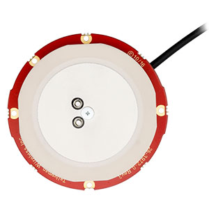
The M9HCT-A-SMA is a patented helix antenna for GNSS plus L-band corrections services, suitable for high-precision and autonomous multi-frequency applications. It provides simultaneous GNSS reception in a rugged, compact form factor. The M9HCT-A-SMA is suitable for high-precision applications such as the UAV market, where high performance and low weight are driving features in antenna selection. The active helix design features Maxtena’s patented compact and lightweight Helicore technology, which provides excellent pattern control, polarization purity and high efficiency in a compact form factor.
New eXtended Filtering (XF) is now employed in the TW3900 series of Accuntena precision antennas. The XF feature mitigates interference from all near-band signals and ensures the antenna provides the purest possible GNSS signals. The custom XF filtering has been tested to mitigate new (in Europe and Japan) and existing LTE signals, enabling the XF antennas to produce clean and pure GNSS radio frequency data. The XF models are TW3972XF, TW3972EXF, TW3972LGXF, TW3967XF and TW3967LGXF. All are triple-band antennas that support GPS/QZSS (L1/L2/L5), GLONASS (G1/G2/G3), Galileo (E1/E5ab), BeiDou (B1/B2/B2a), NavIC L5 and L-band correction services.
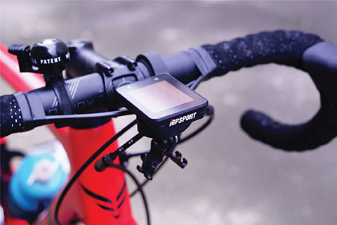
The iGS320 cycling computer builds on the u-blox M10 positioning platform, leveraging the M10’s ultra-low power consumption, compact size, and ability to track all four GNSS to offer endurance athletes a superior user experience. Adopting the M10 in its iGS320 cycling computer brought iGPSPORT an 80 percent increase in the power autonomy to deliver 72 hours of continuous tracking, up from 40 hours in their previous device. Concurrent reception of up to four GNSS constellations increases coverage and accuracy in otherwise challenging signal environments.
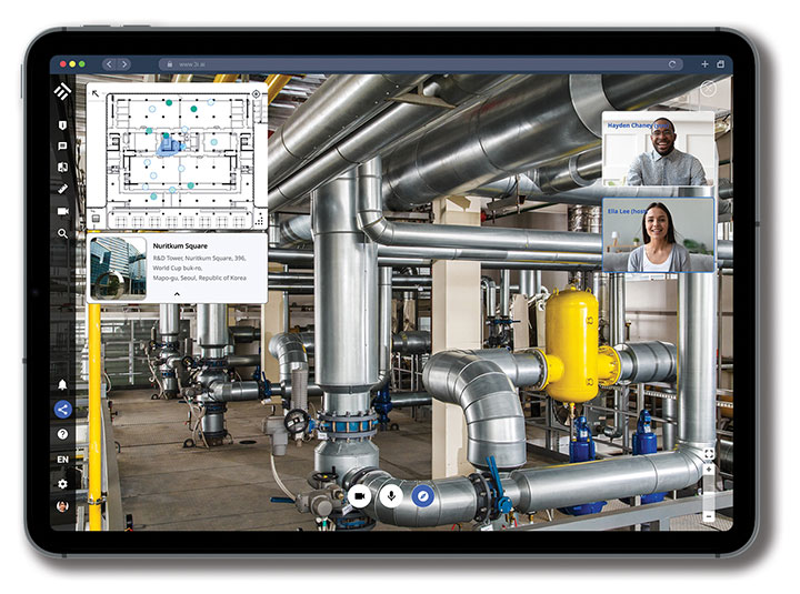
The Beamo 3D mapping platform enables surveyors to scan a project site and immediately collaborate with teams in the field without lengthy delays or cumbersome equipment. The digital twin created in the platform provides a single and secure source of truth for teams without requiring highly technical knowledge. With a 360-degree camera, surveyor teams can create detailed digital environments that remote teams can use to track progress, collaborate with coworkers, and take accurate measurements without having to physically visit the site.
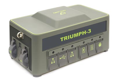
The Triumph-3 receiver tracks efficiently even in difficult conditions. It can track all current signals and is ready for future satellites. The Triumph-3 can operate as a base together with Triumph-LS and Triumph-LS Plus to efficiently accomplish any geodetic job. Its RTK system communicates via integrated UHF, 4G/LTE, Wi-Fi and Bluetooth channels, and eliminates the need to subscribe to a real-time network for corrections. A powerful and reliable receiver for high-precision navigation systems, the Triumph-3 is based on the Javad GNSS 874-channel chip. It is equipped with an internal 4G/LTE/3G card and secure and accessible microSD and microSIM cards. It also supports Javad’s lift-and-tilt technology.
Eos Bridge enables almost any instrument to become iOS Bluetooth compatible. The pocket-sized device connects to instruments via Bluetooth Classic or serial port, and then transmits data to any Apple iOS device, such as iPhone or iPad, Android device or Windows mobile device. Instruments equipped with non-iOS Bluetooth can connect to Apple iOS devices using the Eos Bridge, including laser rangefinders and utility-locating instruments. Instruments whose only connectivity option is a serial port also can connect, such as any instrument or sensor with an RS-232 serial port. The Eos Bridge is lightweight, at approximately 150 grams (about 5.3 ounces). It can be worn clipped to a belt, stored in a pocket, or mounted to an instrument or sensor. The battery lasts 48 to 72 hours.
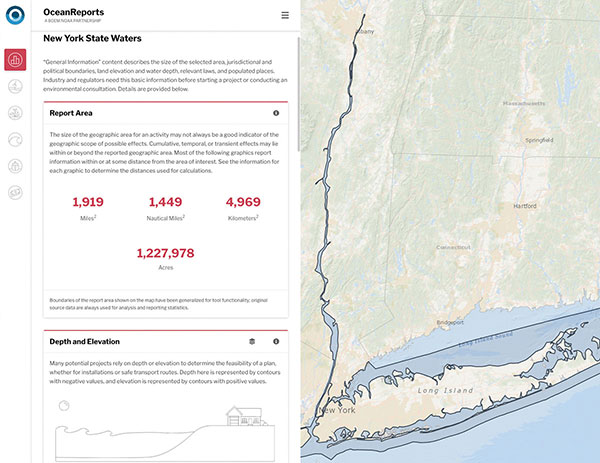
The OceanReports web tool provides users with specialized “ocean neighborhood analyses,” including maps and graphics, by analyzing more than 100 ocean datasets instantaneously. Reporting data includes information about habitats and species, industries in the area, potential hazards (such as undersea cables or shipwrecks), the economic value of ocean commerce, and other detailed oceanographic information. The web-based interactive tool for ocean mapping and planning, created by the National Oceanic and Atmospheric Administration (NOAA) and the Department of the Interior’s Bureau of Ocean Energy Management, provides professional users and the general public with opportunities to explore the ocean from their own computer.
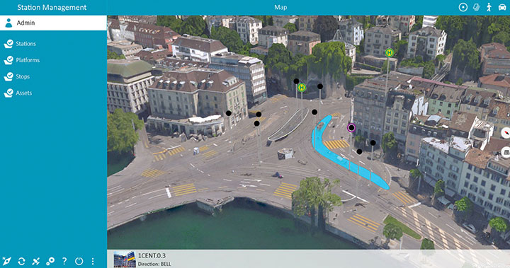
HxGN Mass Transit is a geospatial transportation infrastructure management system with 3D and AI capabilities for visualizing and analyzing transit and rail assets and operations. Built on Hexagon’s M.App Enterprise, HxGN Mass Transit provides an advanced digital twin of a city’s entire public transportation network — including tracks, stops, switches, construction sites, ticket machines, benches and garbage cans. It integrates asset and spatial data so operators can visualize and analyze an entire network with accurate and up-to-date information.
The GAJT-410MS provides anti-jamming to marine vessels. (Image: NovAtel)
The GAJT-410MS provides NovAtel’s GPS Anti-Jam Technology (GAJT) for the commercial and defense marine markets. The low SWaP variant protects civil and military operations from interference and jamming, with jammer direction-finding capabilities for enhanced situational awareness in the marine environment. The GAJT-410MS provides dynamic protection on both GPS L1 and L2 bands, as well as Galileo E1, QZSS L1 and L2, and SBAS L1 to combat intentional and unintentional interference.
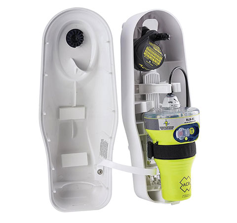
The ACR 2830 GlobalFix V4 EPIRB marine distress beacon has multiple built-in redundancies to increase chances of survival in an emergency situation. The internal GPS receiver pinpoints the user’s location, which is then transmitted on the 406-MHz distress signal. In the absence of GPS-derived coordinates, the signal can be used to triangulate the position. The beacon’s 121.5 MHz homing signal will bring local search-and-rescue forces directly to the position; an LED strobe light allows them to see the position in low light. A Category 1 Emergency Position Indicating Radio Beacon (EPIRB), the GlobalFix V4 is a float-free device that will automatically activate when submerged in water. Two self-tests monitor transmission, power and battery performance as well as GPS acquisition.
A new connected platform for rail passengers with Wi-Fi, information and entertainment content is being installed on OUIGO Spain trains through the OUIFUN portal. Passengers can connect via smartphones, tablets or PCs, access the internet on board to check email or browse the web, and enjoy entertainment content. Passengers also will be able to get travel status information in real time via an interactive map, access tourist guides or consult a menu for on-board catering. The service, provided by Moment, launched on May 10 on OUIGO’s first high-speed line in Spain connecting Madrid to Barcelona, and will gradually be extended to the whole high-speed OUIGO network.
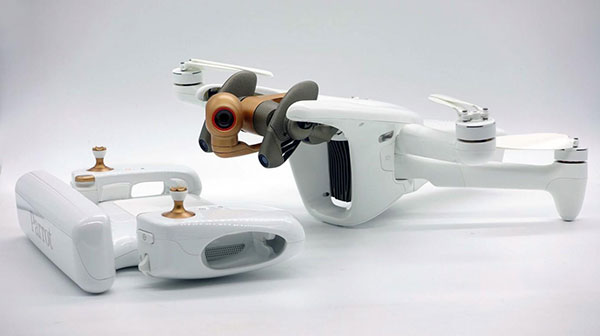
The ANAFI Ai UAV uses 4G as its main data link between the drone and the operator. The 4G link improves data transmission and enables precise control at any distance. For BVLOS flights, it stays connected even behind obstacles. The 4G link between the drone and the user’s phone is encrypted, with a secure element protecting both software integrity and data privacy. A software development kit enables creation of custom code for flights and gives access to all sensors, including obstacle-avoidance sensors, occupancy grid and internet access.
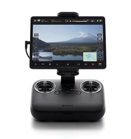
An introductory model in Sony’s new Airpeak line, the small S1 drone can be equipped with the company’s full-size mirrorless interchangeable-lens Alpha camera. Its proprietary motor, propeller, control system and sensing technology allow it to fly at high speed (a maximum speed of 55 mph) with stable wind resistance. Propulsion technology using a combination of devices developed by Sony provides wind resistance in strong wind speeds up to 44.7 mph. The Airpeak S1 includes obstacle detection, automatic flight control via sensing, and increased safety via cloud management of the aircraft.
At 80 grams, George is a low SWaP certifiable solution for enterprise operations and those wishing to type certify their UAS. Built around the open-source autopilot Cube from CubePilot, George combines Cube with Design Assurance Level C (DAL-C) hardware and safety and sensor monitoring, enabling customers to meet the type certification and safety case requirements for BVLOS operations. Its triple-redundant IMU includes three accelerometers, three gyroscopes, three magnetometers and three barometers. The hardware platform is designed and built to RTCA DO-254 DAL-C and meets rigorous DO-160G and MIL-810H power and environmental qualifications.
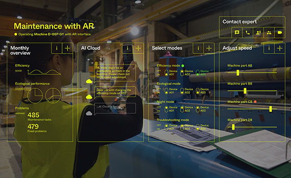
Hexagon AB has acquired Immersal Oy, an innovator of spatial mapping and visual positioning solutions for producing augmented reality (AR) applications.
AR applications enhance real-world experiences by augmenting a user’s visual perception with the display of digital content in the physical world.
AR’s ability to weave context-specific, 3D information into physical spaces provides endless opportunities to save time, improve performance and reduce costs across a wide range of industries and applications — from surveying, construction, public safety and manufacturing to maintenance, training and navigation applications.
An immersive experience can help boost task efficiency, improve safety protocols, optimize workflows and increase collaboration.
The Immersal SDK (software development kit) allows developers to merge and “anchor” digital content to real-world objects – with precise accuracy to their actual location in the physical space — by enabling a user’s mobile device to locate and orient itself in the surrounding physical world using machine-readable maps.
The maps, which are used for visual positioning, are constructed from image data supported by various mapping devices (including mobile phones) and hosted in the Immersal Cloud Service.
“Hexagon has long been a leader in delivering smart digital realities that combine inputs from reality capture sensors with advanced visualisation software and tools to enable remote, location-based intelligence. This acquisition puts the power of these insights into the hands of those on-site, enhancing their field of view with superimposed digital information, meaning they can literally do more with what they see,” said Hexagon President and CEO Ola Rollén. “For example, direct access to information about an asset — while working with that asset — including step-by-step instructions on how to repair it, can streamline maintenance tasks while reducing material waste and re-work.”
Immersal has years of experience developing AI and machine learning-based spatial anchor technology, which “anchors” virtual objects or models for viewing on different devices in the same position and orientation. This unlocks a wide variety of location-based solutions and services — from consumer-oriented augmented reality applications in gaming and media and entertainment to digital twin solutions on an enterprise scale.
Immersal’s technology can map large spaces — both indoors and outdoors — and works both offline on-device and online using the Cloud Service.
Founded in 2015 and headquartered in Helsinki, Finland, Immersal will operate as part of Hexagon’s Geosystems division. The acquisition has no significant impact on Hexagon’s earnings.
Hexagon AB has acquired Tacticaware, which provides lidar-based 3D surveillance software to monitor and protect critical infrastructure and buildings.
Tacticaware’s flagship solution, Accur8vision, is a volumetric detection security system offering 3D surveillance. Unlike conventional systems that typically only monitor perimeters, Accur8vision delivers situational awareness of an intruder’s exact location, size, speed and movement trajectory — all of which can be visualized within a 3D digital reality of the area under surveillance, Tacticaware said.
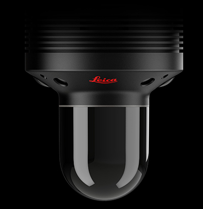
“Hexagon has long been a leader in sensor and 3D visualization technology,” said Hexagon President and CEO Ola Rollén. “Our award-winning 3D surveillance solution, Leica BLK247, fuses lidar, video and thermal imaging with edge computing and intelligent algorithms to instantly detect and report physical changes within an environment. Together with the BLK247 and HxGN OnCall, our comprehensive portfolio of next-generation public safety solutions, Hexagon can now offer those working to make our world a safer place a fully integrated end-to-end security surveillance solution for 24-hour, full visibility of critical infrastructure and spaces to call-taking, dispatch, incident planning and response and more.”
Hexagon AB, which offers sensor, software and autonomous solutions, has signed an agreement to acquire Volume Graphics, a specialist in industrial computed tomography (CT) software.
Volume Graphics brings more than 20 years of experience in non-destructive inspection and testing software development. The company’s high-end analysis and visualization CT software enables manufacturers to produce three-dimensional external and internal representations of scanned objects.
Using CT, they’re able to “see” inside the complicated structures of components, otherwise inaccessible with traditional inspection methods. This allows hidden or hard to reach internal features to be measured and inspected for dimensional deviations and flaws without destroying the parts and compromising the integrity of the data in the process.
“Volume Graphics offers an invaluable toolset for leveraging CT data across many use cases — from flaw detection and failure analysis to reverse engineering applications,” said Hexagon President and CEO Ola Rollén. “We look forward to merging our capabilities so that customers can ensure the highest product quality throughout product development and production. Additionally, industrial CT scanning is fast becoming a critical asset to manufacturers as more and more industries embrace additive manufacturing. The addition of CT software capabilities strengthens our portfolio in this growth area.”
Today, a broad range of global customers from the automotive, aerospace and electronics industries use Volume Graphics software for quality assurance.
Founded in 1997 and headquartered in Heidelberg, Germany, Volume Graphics employs around 160 people worldwide. Subsidiaries in Japan, Singapore, China and the U.S., supplemented by an extensive reseller network, deliver its software to customers in more than 50 countries.
Volume Graphics will operate as part of Hexagon’s Manufacturing Intelligence division. Completion of the transaction (closing) is subject to regulatory approvals. 2018 sales amounted to 25 MEUR.
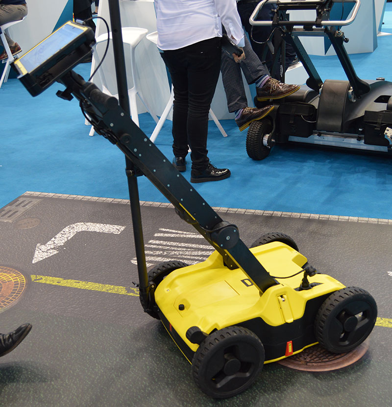
Hexagon showcased the Leica DSX utility detection solution at Intergeo 2019. (Photo: Allison Barwacz)
Hexagon AB presented its Smart Buildings & Infrastructure and Smart Cities & Nations portfolios at Intergeo 2019, which took place Sept. 17-19 in Stuttgart, Germany.
At the show, the company exhibited a number of its solutions designed to help manage the life of a building — from initial land surveying, through design, build, maintenance, renovation and demolition — and optimize the completion of infrastructure projects. These solutions include the Leica DSX utility detection solution, the BricsCAD building design software and HxGN SmartBuild.
Reality capture solutions showcased at Intergeo 2019 include Hexagon’s Leica BLK2GO mobile reality capture solution, the HxGN Content Program, and the Hexagon Smart M.Apps and Luciad portfolios.
“The ultimate form of data leverage is when tasks and processes become autonomous, which is the goal of our smart solutions portfolios,” said Ola Rollén, president and CEO at Hexagon. “We help customers leverage the data within their workflows to achieve the greatest efficiency, productivity and quality outcomes possible. When we collectively achieve these outcomes at scale, not only can we sustain growth for our businesses, but also this finite planet we all share…fewer resources, less waste, less pollution.”
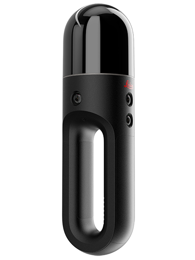
Hexagon AB has introduced two new additions to its Leica BLK series. The Leica BLK2GO is a small, portable, integrated handheld-imaging scanner, and the Leica BLK247 is a 3D laser-scanning sensor for security surveillance providing continuous, 24/7 situational awareness.
“Extending the BLK series continues Hexagon’s 20-year focus on revolutionising reality capture,” said Ola Rollén, Hexagon president and CEO. “These sensors are not only ground-breaking for their technical capabilities, but also for their practicality. The Leica BLK2GO can be taken anywhere, and the Leica BLK247 never sleeps.”
Leica BLK2GO. The Leica BLK2GO introduces mobility for scanning complex indoor environments. The handheld-imaging laser scanner combines visualisation, lidar, and edge-computing technologies to scan in 3D while in motion, allowing users to be more agile and efficient in capturing objects and spaces.
The BLK2GO has a wide range of applications from adaptive reuse projects in the architecture and design industries to location scouting, pre-visualisation, and VFX workflows for media and entertainment.
The Leica BLK247. (Photo: Hexagon)
Leica BLK247. The Leica BLK247 is designed for continuous 3D reality capture, extending capabilities for safety and security applications. The sensor provides real-time situational awareness through edge computing and LiDAR-enabled change-detection technology.
Using artificial intelligence, the BLK247 can tell the difference between still and moving objects — such as a person walking who leaves a suitcase behind — and identify security threats to provide real-time alerts for both expected and unexpected changes.
The BLK247 greatly enhances situational awareness within restricted or high-security spaces, as it eliminates the need for people to constantly monitor walls of security screens or smart building dashboards.
The Leica BLK2GO and Leica BLK247 are among the many innovative solutions showcased this week at HxGN LIVE 2019, Hexagon’s annual digital technology conference.